
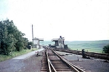
Parsley Hay railway station
Encyclopedia
Parsley Hay railway station served Parsley Hay, a hamlet about 15 km south east of Buxton
, Derbyshire
, on the LNWR line to Ashbourne
. The nearest large settlement is the village of Hartington
.
(which ran from Whaley Bridge
to Cromford
). It opened for passengers in 1856 but closed in 1877. The line was acquired by LNWR and extended to Buxton
in 1894 and the station was reopened. In 1899 the LNWR built a junction just south of the station for a line to Ashbourne
and built a new station.
 In common with the other stations on this line, the platforms and buildings were of timber construction. From this point on to Ashbourne the line was single with passing loops at the stations, though provision was made for doubling which never occurred.
In contrast to the first part of the line from Buxton, from the previous station at Hurdlow
the line had dropped gently and this continued to the next at Hartington
, though the curves involved limited the linespeed to 40 mph.
The station closed in October, 1963 while the line southwards closed in October, 1967 with that to Hindlow following in November.
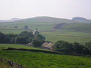
Today these two disused trackbeds form the route of two walking and cycling routes. The High Peak Trail follows the old Cromford and High Peak, and the name Parsley Hay has become synonymous with the cycle centre here.
The track bed from Ashbourne to Parsley Hay was acquired by Derbyshire County Council and the Peak National Park to become the Tissington Trail
which was one of the first of such ventures in the country. Later, Ashbourne Tunnel was acquired by Sustrans
. Parsley Hay, being located a little to the north of the junction of these walk/cycleways, is ideally located for a cycle hire centre (run by the Park Authority) and a refreshment kiosk serving drinks and snacks all day. There are also toilets here, and a large car park.
The trackbed at this point is also part of the Pennine Bridleway
, a 130-mile leisure route which includes 73 miles through Derbyshire.
Buxton
Buxton is a spa town in Derbyshire, England. It has the highest elevation of any market town in England. Located close to the county boundary with Cheshire to the west and Staffordshire to the south, Buxton is described as "the gateway to the Peak District National Park"...
, Derbyshire
Derbyshire
Derbyshire is a county in the East Midlands of England. A substantial portion of the Peak District National Park lies within Derbyshire. The northern part of Derbyshire overlaps with the Pennines, a famous chain of hills and mountains. The county contains within its boundary of approx...
, on the LNWR line to Ashbourne
Ashbourne, Derbyshire
Ashbourne is a small market town in the Derbyshire Dales, England. It has a population of 10,302.The town advertises itself as 'The Gateway to Dovedale'.- Local customs :...
. The nearest large settlement is the village of Hartington
Hartington
Hartington is a village in the Derbyshire Peak District, England, lying on the River Dove close to the Staffordshire border. According to the 2001 census, the parish of Hartington Town Quarter, which also includes Pilsbury, had a population of 345...
.
History
It was originally opened in 1833 for goods by the Cromford and High Peak RailwayCromford and High Peak Railway
The Cromford and High Peak Railway in Derbyshire, England, was completed in 1831, to carry minerals and goods between the Cromford Canal wharf at High Peak Junction and the Peak Forest Canal at Whaley Bridge -Origins:...
(which ran from Whaley Bridge
Whaley Bridge
Whaley Bridge is a small town and civil parish in the High Peak district of Derbyshire, England, situated on the River Goyt. Whaley Bridge is approximately south of Manchester, north of Buxton , east of Macclesfield and west of Sheffield, and had a population of 6,226 at the 2001 census. This...
to Cromford
Cromford
Cromford is a village, two miles to the south of Matlock in the Derbyshire Dales district in Derbyshire, England. It is principally known for its historical connection with Richard Arkwright, and the Cromford Mill which he built here in 1771...
). It opened for passengers in 1856 but closed in 1877. The line was acquired by LNWR and extended to Buxton
Buxton
Buxton is a spa town in Derbyshire, England. It has the highest elevation of any market town in England. Located close to the county boundary with Cheshire to the west and Staffordshire to the south, Buxton is described as "the gateway to the Peak District National Park"...
in 1894 and the station was reopened. In 1899 the LNWR built a junction just south of the station for a line to Ashbourne
Ashbourne Line
The Ashbourne Line was a railway from Buxton via Ashbourne to Uttoxeter. It was built by the London and North Western Railway using a section of the Cromford and High Peak Railway and it joined the North Staffordshire Railway at Ashbourne, proceeding to Uttoxeter with a junction onto the main...
and built a new station.
In contrast to the first part of the line from Buxton, from the previous station at Hurdlow
Hurdlow railway station
Hurdlow railway station was near to the hamlet of Hurdlow to the south east of Buxton, Derbyshire on the LNWR line to Ashbourne and the south.-History:...
the line had dropped gently and this continued to the next at Hartington
Hartington railway station
Hartington railway station opened in 1899 about two miles away from the village it served - Hartington in Derbyshire, south east of Buxton....
, though the curves involved limited the linespeed to 40 mph.
The station closed in October, 1963 while the line southwards closed in October, 1967 with that to Hindlow following in November.
Today these two disused trackbeds form the route of two walking and cycling routes. The High Peak Trail follows the old Cromford and High Peak, and the name Parsley Hay has become synonymous with the cycle centre here.
The track bed from Ashbourne to Parsley Hay was acquired by Derbyshire County Council and the Peak National Park to become the Tissington Trail
Tissington Trail
right|thumb|200px|The Trail at the site of the former Tissington station, now a picnic site.The Tissington Trail is a bridleway and walk/cycle path in Derbyshire, England...
which was one of the first of such ventures in the country. Later, Ashbourne Tunnel was acquired by Sustrans
Sustrans
Sustrans is a British charity to promote sustainable transport. The charity is currently working on a number of practical projects to encourage people to walk, cycle and use public transport, to give people the choice of "travelling in ways that benefit their health and the environment"...
. Parsley Hay, being located a little to the north of the junction of these walk/cycleways, is ideally located for a cycle hire centre (run by the Park Authority) and a refreshment kiosk serving drinks and snacks all day. There are also toilets here, and a large car park.
The trackbed at this point is also part of the Pennine Bridleway
Pennine Bridleway
The Pennine Bridleway is a new National Trail under designation in Northern England.It runs roughly parallel with the Pennine Way but provides access for horseback riders and cyclists as well as walkers. The trail is around long; through Derbyshire to the South Pennines, the Mary Towneley Loop...
, a 130-mile leisure route which includes 73 miles through Derbyshire.