
Parks of Bristol
Encyclopedia
.jpg)
Bristol
Bristol is a city, unitary authority area and ceremonial county in South West England, with an estimated population of 433,100 for the unitary authority in 2009, and a surrounding Larger Urban Zone with an estimated 1,070,000 residents in 2007...
has a number of parks and public open spaces.
Large parks
Politics of Bristol
The city of Bristol, England, is a unitary authority, represented by four MPs representing seats wholly within the city boundaries. As well as these, Filton and Bradley Stoke covers the northern urban fringe in South Gloucestershire and the north eastern urban fringe is in the Kingswood constituency...
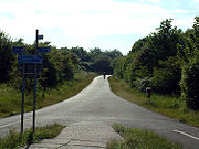
own or manage four major parks: The Downs, Blaise Castle
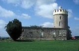
Blaise Castle
Blaise Castle is an 18th century mansion house and estate near Henbury in Bristol , England. Blaise Castle was immortalised by being described as "the finest place in England" in Jane Austen's novel Northanger Abbey....
, Ashton Court
Ashton Court
Ashton Court is a mansion house and estate to the west of Bristol in England. Although the estate lies mainly in North Somerset, it is owned by the City of Bristol. The estate has been a venue for a variety of leisure activities, including the now-defunct Ashton Court festival, Bristol...
and Stoke Park
Stoke Park, Bristol
Stoke Park is a public open space of in Bristol, England. It occupies a prominent position alongside the M32 motorway, together with the landmark Dower House and Purdown transmitter....
.
The Downs lie 2 miles (3 km) northwest of the city centre and totals 441 acres (1.8 km²). The Downs are divided into Clifton Down
Clifton Down
Clifton Down is an area of public open space in Bristol, England, north of the village of Clifton. With its neighbour Durdham Down to the northeast, it constitutes the large area known as The Downs, much used for leisure including walking and team sports...
to the south and Durdham Down
Durdham Down
Durdham Down is an area of public open space in Bristol, England. With its neighbour Clifton Down to the southwest, it constitutes a area known as The Downs, much used for leisure including walking, jogging and team sports. Its exposed position makes it particularly suitable for kite flying...
to the north, with a main road running between them. At the south end of Clifton Down is the Clifton Suspension Bridge
Clifton Suspension Bridge
Brunel died in 1859, without seeing the completion of the bridge. Brunel's colleagues in the Institution of Civil Engineers felt that completion of the Bridge would be a fitting memorial, and started to raise new funds...
, and both look over the Avon Gorge
Avon Gorge
The Avon Gorge is a 1.5-mile long gorge on the River Avon in Bristol, England. The gorge runs south to north through a limestone ridge west of Bristol city centre, and about 3 miles from the mouth of the river at Avonmouth. The gorge forms the boundary between the unitary authorities of...
. The Downs are protected by an 1861 Act of Parliament
Act of Parliament
An Act of Parliament is a statute enacted as primary legislation by a national or sub-national parliament. In the Republic of Ireland the term Act of the Oireachtas is used, and in the United States the term Act of Congress is used.In Commonwealth countries, the term is used both in a narrow...
, and are managed by the Downs Committee, a joint committee of the city council (which owns Durdham Down) and the Society of Merchant Venturers
Society of Merchant Venturers
The Society of Merchant Venturers is a private entrepreneurial and charitable organisation in the English city of Bristol, which dates back to the 13th century...
(which owns Clifton Down).
Blaise Castle estate, situated 4 miles (6 km) north west of the city centre, includes a recreation ground and large playing fields, as well as woodland, a mansion, and a small gorge, totalling 650 acres (2.6 km²). The mansion house is now a branch of Bristol City Museum and Art Gallery
Bristol City Museum and Art Gallery
The Bristol City Museum and Art Gallery is a large museum and art gallery in Bristol, England. It is run by the city council with no entrance fee. It holds designated museum status, granted by the national government to protect outstanding museums...
.
At 850 acres (3.4 km²) Ashton Court estate is Bristol's largest park. Though the estate lies largely within the boundaries of North Somerset
North Somerset
North Somerset is a unitary authority in England. Its area covers part of the ceremonial county of Somerset but it is administered independently of the non-metropolitan county. Its administrative headquarters is in the town hall in Weston-super-Mare....
it is maintained by Bristol City Council, and has been publicly owned since 1959. The park contains horse riding
Equestrianism
Equestrianism more often known as riding, horseback riding or horse riding refers to the skill of riding, driving, or vaulting with horses...
and mountain biking
Mountain biking
Mountain biking is a sport which consists of riding bicycles off-road, often over rough terrain, using specially adapted mountain bikes. Mountain bikes share similarities with other bikes, but incorporate features designed to enhance durability and performance in rough terrain.Mountain biking can...
trails, and is protected as a Site of Special Scientific Interest
Site of Special Scientific Interest
A Site of Special Scientific Interest is a conservation designation denoting a protected area in the United Kingdom. SSSIs are the basic building block of site-based nature conservation legislation and most other legal nature/geological conservation designations in Great Britain are based upon...
for its ecology. The mansion house is now a conference centre.
Stoke Park is Bristol's newest park, acquired by Bristol City Council in 2011 and occupying a prominent position alongside the M32 motorway
M32 motorway
The M32 is a motorway in South Gloucestershire and Bristol, England. It provides a link from Bristol city centre to the M4 and is part of the Bristol Parkway. At about , it is one of Britain's shortest motorways...
.
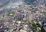
Parks and open spaces in the central area
The Centre Promenade is a paved, largely pedestrianised area built over the culverted River Frome. Known locally as the CentreThe Centre, Bristol
The Centre is a partially pedestrianised public open space in the central area of Bristol, England, created by covering over the River Frome. The northern end of The Centre is a paved area circuited by Colston Avenue; the southern end is separated from this by a major road junction and is a larger...
, many local bus services terminate here.
Castle Park
Castle Park, Bristol
Castle Park is a public open space in Bristol, England, managed by Bristol City Council. It is bounded by the Floating Harbour and Castle Street to the south, Lower Castle Street to the east, and Broad Weir, Newgate and Wine Street to the north...
is adjacent to the Broadmead
Broadmead
Broadmead is a street in the central area of Bristol, England, which has given its name to the principal shopping district of the city.- History :The name of the street was first recorded in 1383 as Brodemede...
and Cabot Circus
Cabot Circus
Cabot Circus is a shopping centre in Bristol, England. It is adjacent to Broadmead, a shopping district in Bristol city centre. The Cabot Circus development area contains shops, offices, a cinema, hotel and 250 apartments. It covers a total of floor space, of which is retail outlets and leisure...
shopping centres and the Floating Harbour
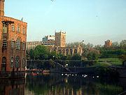
Bristol Harbour
Bristol Harbour is the harbour in the city of Bristol, England. The harbour covers an area of . It has existed since the 13th century but was developed into its current form in the early 19th century by installing lock gates on a tidal stretch of the River Avon in the centre of the city and...
. The park was created after wartime bombing
Bristol Blitz
Bristol was the fifth most heavily bombed British city of World War II. The presence of Bristol Harbour and the Bristol Aeroplane Company made it a target for bombing by the Nazi German Luftwaffe who were able to trace a course up the River Avon from Avonmouth using reflected moonlight on the...
damaged much of the pre-war shopping area which stood here. The ruined shells of two churches, St Peter
St Peter, Bristol
St Peter's was a church in what is now Castle Park, Bristol, England.The church has Saxon foundations, with a 12th century lower tower, the rest of the church being built in the 15th century. Excavations in 1975 suggest that this was the site of Bristol's first church; the 12th century city wall...
and St Mary le Port
St Mary le Port Church, Bristol
St Mary le Port is a ruined parish church in the centre of Bristol, England. It is said to have been founded in Saxon times, and rebuilt and enlarged between the 11th and 16th centuries....
, still stand in the park (with the aid of concrete reinforcements) and the foundations of Bristol Castle
Bristol Castle
Bristol Castle was a Norman castle built for the defence of Bristol. Remains can be seen today in Castle Park near the Broadmead Shopping Centre, including the sally port.-History:...
are also a feature. There are small formal gardens around St Peter's church, which is maintained as a war memorial. Bristol City Council has confirmed its intention to redevelop the area around St Mary-le-Port church. The project area includes a part of Castle Park to the west of St Peter's Church.
To the west of the city centre lie Berkeley Square
Berkeley Square, Bristol
Berkeley Square is close to Park Street in the Clifton area of Bristol.It was laid out around 1790 in Georgian style with a central grass area behind railings, by Thomas and William Paty....
and Brandon Hill
Brandon Hill, Bristol
Brandon Hill, also known as St Brandon's Hill, is a hill close to Bristol city centre, between the districts of Clifton and Hotwells, in south west England....
. At the summit of Brandon Hill, the Cabot Tower commemorates John Cabot
John Cabot
John Cabot was an Italian navigator and explorer whose 1497 discovery of parts of North America is commonly held to have been the first European encounter with the continent of North America since the Norse Vikings in the eleventh century...
, a pioneer who sailed in 1497 from Bristol to Newfoundland. Brandon Hill is steep and is divided into informal gardens, a small nature reserve
Nature reserve
A nature reserve is a protected area of importance for wildlife, flora, fauna or features of geological or other special interest, which is reserved and managed for conservation and to provide special opportunities for study or research...
and open grassland. The Avon Wildlife Trust
Avon Wildlife Trust
The Avon Wildlife Trust aims to protect and promote wildlife in the area of the former county of Avon — now Bath and North East Somerset, Bristol, North Somerset and South Gloucestershire, in England...
headquarters are beside the park.
Surrounded with high wrought-iron railings to the northwest of Broadmead shopping centre, St James' Park is a small former churchyard divided by a sunken walkway which links Broadmead to St James' Church and Bristol Bus Station
Bristol Bus Station
Bristol Bus and Coach Station serves the city of Bristol in the west of England. It is situated at Marlborough Street, near the Broadmead shopping area...
.
West of the city centre between Bristol Cathedral
Bristol Cathedral
The Cathedral Church of the Holy and Undivided Trinity is the Church of England cathedral in the city of Bristol, England, and is commonly known as Bristol Cathedral...
and the Council House
Council House, Bristol
The Council House has been the seat of local government in Bristol, England since 1956. It is situated on College Green, opposite the Cathedral and at the foot of Park Street in Bristol city centre . Throughout its history it has been home to Bristol city council.It was designed in the 1930s but...
is College Green
College Green, Bristol
College Green is a public open space in Bristol, England. The Green takes the form of a segment of a circle with its apex pointing east, and covers...
, a popular meeting place for street sports
Street sports
Street sports is a used to describe a number of sports held in urban environments. Other key characteristics attributable include their non-commercial and non-professional nature. Street sports are an expression of the spontaneous, improvisational and creative origins of sport adapted by human...
enthusiasts.
Queen Square
Queen Square, Bristol
Queen Square is a garden square in the centre of Bristol, England. It was originally a fashionable residential address, but now most of the buildings are in office use....
is a large Georgian
Georgian architecture
Georgian architecture is the name given in most English-speaking countries to the set of architectural styles current between 1720 and 1840. It is eponymous for the first four British monarchs of the House of Hanover—George I of Great Britain, George II of Great Britain, George III of the United...
square south of the city centre. In 1936 the Square was bisected diagonally by Bristol's inner circuit road. Traffic has now been diverted, and the restored Square has received a number of awards including a Green Flag Award
Green Flag Award
The Green Flag Award is the benchmark national standard for parks and green spaces in the United Kingdom. The scheme was set up in 1996 to recognise and reward green spaces in England and Wales that met the laid down high standards...
,
the Landscape Institution Landscape and Heritage Award.
King Square (restored in 1993), Brunswick Square and Portland Square are also Georgian and lie to the north of the city centre.
The Bear Pit, a sunken space within St James Barton roundabout, has long been seen as in need of improvement.
 |
 |
Other parks
- Arnos Vale CemeteryArnos Vale CemeteryArnos Vale Cemetery , located in Arno's Vale in Bristol, England, was established in 1837. Its first burial was in 1839. The cemetery followed a joint-stock model, funded by shareholders. It was laid out as an Arcadian landscape with buildings by Charles Underwood.Arnos Vale cemetery is located on...
- Begbrook Green Park
- Bristol & Bath Railway Path, a green corridor following the route of a dismantled railway.
- Canford Park
- Chester ParkChester Park, BristolChester Park is a residential area in Bristol, England, with an adjacent park commonly known as Barton Fields.It is on the outskirts of the outer urban area of Fishponds, adjacent to Mayfield Park, Speedwell, Kingswood, Hillfields and Lodge Causeway...
- Cotham Gardens
- Dame Emily Park
- Eastville Park
- Greville Smyth Park
- Hengrove Park
- Lamplighters MarshLamplighters MarshLamplighters Marsh is a public open space near Shirehampton in the city of Bristol, England. It is a narrow strip of land between the railway line which connects Bristol to Avonmouth, and the River Avon....
- Leigh WoodsLeigh WoodsLeigh Woods is a 2 square kilometre area of woodland on the south-west side of the Avon Gorge, opposite the English city of Bristol and north of the Ashton Court estate. It has been designated as a National Nature Reserve. Small mountain biking circuits are present in the woods and the area is a...
, within North SomersetNorth SomersetNorth Somerset is a unitary authority in England. Its area covers part of the ceremonial county of Somerset but it is administered independently of the non-metropolitan county. Its administrative headquarters is in the town hall in Weston-super-Mare....
). Owned by the National TrustNational Trust for Places of Historic Interest or Natural BeautyThe National Trust for Places of Historic Interest or Natural Beauty, usually known as the National Trust, is a conservation organisation in England, Wales and Northern Ireland...
. - Manor Woods Valley Local Nature Reserve, which has the Malago stream running through it
- Mayfield ParkMayfield Park, BristolMayfield Park is a residential area in East Bristol, with a large adjoining park known as the Ridgeway Rd Playing Fields.The area is located on the outskirts of the outer urban area of Fishponds and consists mainly of three roads: Mayfield Park, Mayfield Park North and Mayfield Park South...
- Mina Road Park
- Montpelier Park
- Oldbury Court Estate (known locally as Vassalls Park)
- Page Park
- Peretts Park
- Redcatch park
- Redland GreenRedland GreenRedland Green is a park in the Bristol suburb of Redland. The park consists of a grassed area and scrub and woodland managed as wildlife habitats by Bristol City Council in partnership with local community groups...
- Snuff MillsSnuff MillsSnuff Mills is a park in the Stapleton area of north Bristol, also known as Whitwood Mill.There are pleasant walks along the steep wooded banks of the River Frome, for example to Oldbury Court...
, owned by the National Trust. - St Agnes Park
- St Andrews Park
- St Annes Park
- St George ParkSt George ParkSt George Park is a park on the eastern edge of the inner city in Bristol, England, in St George. Built on land that was originally The Fire Engine Farm, the park had many fine architectural features. All that remains of these is three of the original gate pillars at the main Church Road entrance....
- Victoria Park