
Parelheiros
Encyclopedia
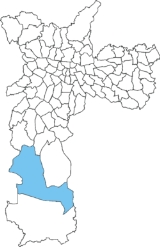
Parelheiros is rural district located in the extreme south (in the subprefecture of Parelheiros
) of the city of São Paulo
, and is also one of the districts with the largest territorial area. Very little of this area is inhabited, and is covered with reserves of the Atlantic Forest. In Parelheiros there are also two indigenous villages of a Guaraní subgroup with about one thousand residents. The region also received many German immigrants in the beginning of 1800. The inhabitants of the place have the lowest purchasing power of the city. The district is poorly served by public transport and roads; there is little connection to the central districts of the city.
The district covers 353 km², representing 24% of São Paulo
, with human occupation 2.5% and scattered 7.7%. With the totality of its territory in areas of protection of springs, the region comprises important parts of the Atlantic Forest and the most preserved areas of the city. It includes parts of the drainage basin
s of the reservoirs Guarapiranga
and Billings, that are responsible for the supply of 30% of the population of Greater São Paulo
. It is cut by a drainage railroad of the agricultural production to the port of Santos and to a disabled suburban extension.
The Colônia crater
, with 3.5 km diameter, is a geologic mark produced by a meteorite many million years ago. Part of it is occupied by 25 thousand people in irregular divisions of lots, another is occupied by a State penitentiary (about 1500 prisoners), and the rest (approximately 50%) is preserved as a traditional agriculture area. The area is maintained by Condephaat (Res. SC 60 de 20.08.2003). It was originally inhabited by Tupi Indians and in the 20th century a Guaraní subgroup established itself there and today there are two villages of the Guaranis - Aldeia Krukutu and Morro da Saudade.
In spite of the restrictions imposed by the environmental legislation, the area presents intense urbanization and disorder, with part of the population living of precarious form and serious impacts on the natural processes of production of water, due to the waterproofing
of the soil, to the deforestation, to the spilling of sewers
and the aggradation
of the bodies of water.
Following the current urbanization process, the population grows in an irregular way, with low income, increasing in an inadequate way the deficit of services and infrastructure. Now the number of the population is of approximately 200.000. The population flow can still increase more with the passage of Rodoanel foreseen to cut the area.
s of the reservoirs Guarapiranga
and Billings
. The dense Atlantic Forest extends south to the region of Marsilac, but is being threatened by increased development of residential real estate, the majority of which are vacation homes of residents of central São Paulo.
s before the arrival of the Germans
(1829). The place received its current name because of the diverse horse-riding races (parelhas, in Portuguese) between the Germans and the Brazil
ians. Before it was known as Santa Cruz (Saint Cross), because a cross existed there, put by a devotee called Amaro de Pontes.
Parelheiros stands out in relation to the Paulista Colony because a road opened in the 19th century, by Henrique Schunck (German), father of the founder of Cipó (nowadays district of Embu-Guaçu
). The street of Parelheiros, nowadays Avenida Sadamu Inoue, connected the villages Embu-Guaçu and São José, where you could leave for the districts Rio Bonito and Santo Amaro, preventing, like this, the passage by the Colonly, where there was the oldest road of Conceição.
In the middle of the 20th century, principally after World War II
, diverse Japanese people disembarked in Port of Santos
. Most of them stayed in the so called Cinturão Verde Metropolitano de São Paulo (Green Metropolitan Belt of São Paulo).
The neighborhoods of Jaceguava and Casa Grande – that are part of the Subprefecture
of Parelheiros – were being occupiedby Japanese families, where they would dedicate to agricultural labor.
Searching for a cheap accommodation, a very numerous population chose the springs of Santo Amaro to reside. With the possibility of finding lower renting costs or even owning a house, with some sacrifice, many lots surged, many of them irregular,because of the publication of the state law of the Protection to the Springs in 1976.
The lack of large spaces in urban areas led into getting into the lands of the caipira
s of Santo Amaro, of a soil exhausted by rudimentary houses. Letting their territories was the best way to get away from the problems, for the increase of taxes territories began making the big properties more expensive. The solution was to divide the country houses and farms into lots, giving place to the emergence of towns, gardens, and parks leaving that the interests of the real estate speculation determined the location of home of the hard-working population, increasing, in the deelimitation of the urban plan, the disorder in the use of the soil.
In 2004, a man between 15 and 24 years was 21 times more likely to die in Parelheiros than in Pinheiros
.
Subprefecture of Parelheiros
The Subprefecture of Parelheiros is one of 31 subprefectures of the city of São Paulo, Brazil. It comprises two districts: Parelheiros and Marsilac....
) of the city of São Paulo
São Paulo
São Paulo is the largest city in Brazil, the largest city in the southern hemisphere and South America, and the world's seventh largest city by population. The metropolis is anchor to the São Paulo metropolitan area, ranked as the second-most populous metropolitan area in the Americas and among...
, and is also one of the districts with the largest territorial area. Very little of this area is inhabited, and is covered with reserves of the Atlantic Forest. In Parelheiros there are also two indigenous villages of a Guaraní subgroup with about one thousand residents. The region also received many German immigrants in the beginning of 1800. The inhabitants of the place have the lowest purchasing power of the city. The district is poorly served by public transport and roads; there is little connection to the central districts of the city.
The district covers 353 km², representing 24% of São Paulo
São Paulo
São Paulo is the largest city in Brazil, the largest city in the southern hemisphere and South America, and the world's seventh largest city by population. The metropolis is anchor to the São Paulo metropolitan area, ranked as the second-most populous metropolitan area in the Americas and among...
, with human occupation 2.5% and scattered 7.7%. With the totality of its territory in areas of protection of springs, the region comprises important parts of the Atlantic Forest and the most preserved areas of the city. It includes parts of the drainage basin
Drainage basin
A drainage basin is an extent or an area of land where surface water from rain and melting snow or ice converges to a single point, usually the exit of the basin, where the waters join another waterbody, such as a river, lake, reservoir, estuary, wetland, sea, or ocean...
s of the reservoirs Guarapiranga
Guarapiranga
The Reservoir of Guarapiranga is a reservoir in the southern area of the city of São Paulo, in the State of São Paulo, Brazil.-Construction:...
and Billings, that are responsible for the supply of 30% of the population of Greater São Paulo
Greater São Paulo
The Greater São Paulo is a nonspecific term for one of the multiple definitions the large metropolitan area located in the São Paulo state in Brazil.-Definitions:-Metropolitan Area:...
. It is cut by a drainage railroad of the agricultural production to the port of Santos and to a disabled suburban extension.
The Colônia crater
Colônia crater
The Colônia crater is a presumed impact crater located in the municipality of São Paulo, Brazil. It is a round bowl-shaped depression, without any obvious central bulge, with a diameter of about 3.6 km, bounded by a circular ring of hills about 125 m high relative to the inner depression. Its...
, with 3.5 km diameter, is a geologic mark produced by a meteorite many million years ago. Part of it is occupied by 25 thousand people in irregular divisions of lots, another is occupied by a State penitentiary (about 1500 prisoners), and the rest (approximately 50%) is preserved as a traditional agriculture area. The area is maintained by Condephaat (Res. SC 60 de 20.08.2003). It was originally inhabited by Tupi Indians and in the 20th century a Guaraní subgroup established itself there and today there are two villages of the Guaranis - Aldeia Krukutu and Morro da Saudade.
In spite of the restrictions imposed by the environmental legislation, the area presents intense urbanization and disorder, with part of the population living of precarious form and serious impacts on the natural processes of production of water, due to the waterproofing
Waterproofing
Waterproof or water-resistant describes objects relatively unaffected by water or resisting the ingress of water under specified conditions. Such items may be used in wet environments or under water to specified depths...
of the soil, to the deforestation, to the spilling of sewers
Sanitary sewer
A sanitary sewer is a separate underground carriage system specifically for transporting sewage from houses and commercial buildings to treatment or disposal. Sanitary sewers serving industrial areas also carry industrial wastewater...
and the aggradation
Aggradation
Aggradation is the term used in geology for the increase in land elevation due to the deposition of sediment. Aggradation occurs in areas in which the supply of sediment is greater than the amount of material that the system is able to transport...
of the bodies of water.
Following the current urbanization process, the population grows in an irregular way, with low income, increasing in an inadequate way the deficit of services and infrastructure. Now the number of the population is of approximately 200.000. The population flow can still increase more with the passage of Rodoanel foreseen to cut the area.
Nature
Nowadays it has elevated pluviometric indexes and lower temperature in the winter, with frequent frosts. It is the most preserved area of the city of São Paulo with remainders of the Atlantic Forest (62,4%) and reforestation of about 4% (pinus, eucalyptuses). It includes parts of the drainage basinDrainage basin
A drainage basin is an extent or an area of land where surface water from rain and melting snow or ice converges to a single point, usually the exit of the basin, where the waters join another waterbody, such as a river, lake, reservoir, estuary, wetland, sea, or ocean...
s of the reservoirs Guarapiranga
Guarapiranga
The Reservoir of Guarapiranga is a reservoir in the southern area of the city of São Paulo, in the State of São Paulo, Brazil.-Construction:...
and Billings
Billings
-Places:In Canada:*Billings, OntarioIn Germany:*Billings, HesseIn Russia:*Billings, RussiaIn the United States:* Billings, Montana* Billings, Missouri* Billings, New York* Billings, Oklahoma* Billings County, North Dakota...
. The dense Atlantic Forest extends south to the region of Marsilac, but is being threatened by increased development of residential real estate, the majority of which are vacation homes of residents of central São Paulo.
History
In the region of Parelheiros, there were already some cabocloCaboclo
A caboclo or caboco is a person of a mixed Brazilian Indian and European ancestry. In Brazil, a caboclo is a specific type of mestiço as is the mulato, a person of a mixed Afro-Brazilian and European ancestry....
s before the arrival of the Germans
Germany
Germany , officially the Federal Republic of Germany , is a federal parliamentary republic in Europe. The country consists of 16 states while the capital and largest city is Berlin. Germany covers an area of 357,021 km2 and has a largely temperate seasonal climate...
(1829). The place received its current name because of the diverse horse-riding races (parelhas, in Portuguese) between the Germans and the Brazil
Brazil
Brazil , officially the Federative Republic of Brazil , is the largest country in South America. It is the world's fifth largest country, both by geographical area and by population with over 192 million people...
ians. Before it was known as Santa Cruz (Saint Cross), because a cross existed there, put by a devotee called Amaro de Pontes.
Parelheiros stands out in relation to the Paulista Colony because a road opened in the 19th century, by Henrique Schunck (German), father of the founder of Cipó (nowadays district of Embu-Guaçu
Embu-Guaçu
Embu-Guaçu is a municipality in the state of São Paulo in Brazil. The population in 2006 is 72,170 and the area is 155 km². The elevation is 408.22 m....
). The street of Parelheiros, nowadays Avenida Sadamu Inoue, connected the villages Embu-Guaçu and São José, where you could leave for the districts Rio Bonito and Santo Amaro, preventing, like this, the passage by the Colonly, where there was the oldest road of Conceição.
In the middle of the 20th century, principally after World War II
World War II
World War II, or the Second World War , was a global conflict lasting from 1939 to 1945, involving most of the world's nations—including all of the great powers—eventually forming two opposing military alliances: the Allies and the Axis...
, diverse Japanese people disembarked in Port of Santos
Port of Santos
The Port of Santos is located in the city of Santos, Brazil. As of 2006, it is the busiest container port in Latin America. It possesses a wide variety of cargo handling terminals - solid and liquid bulk, containers and general loads. It is Brazil's leading port in container traffic...
. Most of them stayed in the so called Cinturão Verde Metropolitano de São Paulo (Green Metropolitan Belt of São Paulo).
The neighborhoods of Jaceguava and Casa Grande – that are part of the Subprefecture
Subprefecture
Subprefecture is an administrative division of a country that is below prefecture or province.-Albania:There are twelve Albanian counties or prefectures, each of which is subdivided into several districts, sometimes translated as subprefectures.-Brazil:...
of Parelheiros – were being occupiedby Japanese families, where they would dedicate to agricultural labor.
Searching for a cheap accommodation, a very numerous population chose the springs of Santo Amaro to reside. With the possibility of finding lower renting costs or even owning a house, with some sacrifice, many lots surged, many of them irregular,because of the publication of the state law of the Protection to the Springs in 1976.
The lack of large spaces in urban areas led into getting into the lands of the caipira
Caipira
Caipira is a Brazilian Portuguese term used to designate inhabitants of rural, remote areas of some Brazilian states—it refers to the people of lesser schooling. It can be considered pejorative when used to describe others, but it can also be used as a self-identifier without negative connotations...
s of Santo Amaro, of a soil exhausted by rudimentary houses. Letting their territories was the best way to get away from the problems, for the increase of taxes territories began making the big properties more expensive. The solution was to divide the country houses and farms into lots, giving place to the emergence of towns, gardens, and parks leaving that the interests of the real estate speculation determined the location of home of the hard-working population, increasing, in the deelimitation of the urban plan, the disorder in the use of the soil.
Profile
The Foundation SEADE showed that the young population of this region is the largest in São Paulo.In 2004, a man between 15 and 24 years was 21 times more likely to die in Parelheiros than in Pinheiros
Pinheiros
Pinheiros is a district in the subprefecture of the same name in the city of São Paulo, Brazil. Prior to development, the land which this borough occupies was dominated by the dense forest which contained a Brazilian subtropical species of pine, Araucaria angustifolia, which is also the symbol of...
.