

Papuk Geopark
Encyclopedia
Geopark
A Geopark is defined by the United Nations Educational, Scientific and Cultural Organization in its UNESCO Geoparks International Network of Geoparks programme as follows:...
in Croatia
Croatia
Croatia , officially the Republic of Croatia , is a unitary democratic parliamentary republic in Europe at the crossroads of the Mitteleuropa, the Balkans, and the Mediterranean. Its capital and largest city is Zagreb. The country is divided into 20 counties and the city of Zagreb. Croatia covers ...
which is positioned in two counties, Požega
Požega, Croatia
Požega is a city in western Slavonia, eastern Croatia, with a total population of 26,403 . It is the administrative center of the Požega-Slavonia County.-Geography:...
-Slavonia and Virovitica
Virovitica
Virovitica is a Croatian town near the Croatian-Hungarian border. It is situated near the Drava river and belongs to the historic region of Slavonia. Virovitica has a population of 14,663, with 21,327 people in the municipality...
-Podravina, and seizes upland forests of the Papuk
Papuk
Papuk is the largest mountain in the Slavonia region in eastern Croatia, near the city of Požega. It extends between Bilogora to the northwest, Krndija to the east, and Ravna gora and Psunj to the southwest....
and Krndija
Krndija
Krndija is a hill and village in Slavonia, Croatia, extending eastwards from Papuk. It is located south of Orahovica and Našice and north of Požega....
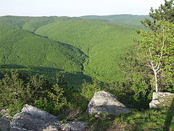
mountains, and edges of agricultural fields. The total area of Park is 33600 hectares. In September 2007, the Papuk Geopark became the first Croatian geopark (an area with an expressed geological heritage and a strategy for a sustainable economical development) and the 30th member of the European and UNESCO
UNESCO
The United Nations Educational, Scientific and Cultural Organization is a specialized agency of the United Nations...
Global Geopark Network.
The Papuk mountains belong to the Slavonia
Slavonia
Slavonia is a geographical and historical region in eastern Croatia...
highlands. The Slavonia highlands have a geographical position in Pannonian, low-laying area of Slavonia. Even though, the Slavonia highlands are not higher than 1,000 meters, their presence is very noticeable in the landscape
Landscape
Landscape comprises the visible features of an area of land, including the physical elements of landforms such as mountains, hills, water bodies such as rivers, lakes, ponds and the sea, living elements of land cover including indigenous vegetation, human elements including different forms of...
. This is because the surrounding alluvial fields are on the 100 m height above the sea level
Sea level
Mean sea level is a measure of the average height of the ocean's surface ; used as a standard in reckoning land elevation...
, while the hillsides are only 100 m above the fields. The highlands are mostly covered with forests, what differ them from the surrounding landscape.
Within the Slavonia highlands, Papuk is the most spacious and most interesting mountain
Mountain
Image:Himalaya_annotated.jpg|thumb|right|The Himalayan mountain range with Mount Everestrect 58 14 160 49 Chomo Lonzorect 200 28 335 52 Makalurect 378 24 566 45 Mount Everestrect 188 581 920 656 Tibetan Plateaurect 250 406 340 427 Rong River...
. The Papuk Mountain is spread out from west to east. From the main mountain-ridge well intended are two spurs and a tract watered by a drainage basin
Drainage basin
A drainage basin is an extent or an area of land where surface water from rain and melting snow or ice converges to a single point, usually the exit of the basin, where the waters join another waterbody, such as a river, lake, reservoir, estuary, wetland, sea, or ocean...
in the direction north south. As a remarkable points, emphasis lays on peaks Točak (887 m), Papuk (953 m), Ivačka glava (913 m), Češljakovački vis (820 m), and Kapovac (792 m), which are spread out continuously, and have a function of water
Water
Water is a chemical substance with the chemical formula H2O. A water molecule contains one oxygen and two hydrogen atoms connected by covalent bonds. Water is a liquid at ambient conditions, but it often co-exists on Earth with its solid state, ice, and gaseous state . Water also exists in a...
separator of the numerous tributary streams
STREAMS
In computer networking, STREAMS is the native framework in Unix System V for implementing character devices.STREAMS was designed as a modular architecture for implementing full-duplex I/O between kernel or user space processes and device drivers. Its most frequent uses have been in developing...
in between river Drava
Drava
Drava or Drave is a river in southern Central Europe, a tributary of the Danube. It sources in Toblach/Dobbiaco, Italy, and flows east through East Tirol and Carinthia in Austria, into Slovenia , and then southeast, passing through Croatia and forming most of the border between Croatia and...
at north, and river Sava at south.
See also
- International Network of GeoparksInternational Network of GeoparksThe Global Geoparks Network is a UNESCO programme established in 1998. Managed under the body’s Ecological and Earth Sciences Division, the GGN seeks the promotion and conservation of the planet’s geological heritage, as well as encourages the sustainable research and development by the concerned...
- List of Geoparks
- Sustainable tourismSustainable tourismSustainable tourism is tourism attempting to make a low impact on the environment and local culture, while helping to generate future employment for local people. The aim of sustainable tourism is to ensure that development brings a positive experience for local people, tourism companies and the...
External links
- Papuk Geopark
- Nature Park Papuk
- Papuk Geopark at the European Geoparks Network
- Global Network of National Geoparks