
Ouadane
Encyclopedia
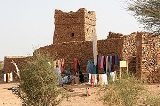
Ouadane or Wadan is a small town in the desert region of central Mauritania
, situated on the southern edge of the Adrar Plateau
, 93 km northeast of Chinguetti
. The town was a staging post in the trans-Saharan trade
and for caravans
transporting slabs of salt from the mines at Idjil. A Portuguese
trading post
was established in 1487, but was probably soon abandoned. The town declined from the sixteenth century and most of the town now lies in ruins.
The old town, a World Heritage Site
, though in ruins, is still substantially intact, while a small modern settlement lies outside its gate.
Ouadane is the closest town to the Richat Structure
, a massive circular landmark visible from space.
gold trade. In the middle of the 11th century, the Arabic geographer al-Bakri described a trans-Saharan route that ran between Tamdoult near Akka
in Morocco
to Aoudaghost
on the southern edge of the Sahara. This route was used for the transport of gold during the time of the Ghana Empire
. In his account al-Bakri mentioned a series of place names but these have not been identified and historians have suggested several possible routes. Raymond Mauny proposed a route that passed through Ouadane but Suzanne Daveau later argued in favour of a more direct route that crossed the Adrar escarpment to the east of the town. The volume of caravan traffic would have declined from the beginning of the 13th century when the oasis town of Oualata
located 360 km to the east replaced Aoudaghost as the southern terminus of the trade route.
The first written reference to the town is in Portuguese
by Ca' de Mosto in middle of the 15th century in a muddled account that confused the salt mines of Idjil with those of Taghaza
. At about the same date Gomes Eanes de Zurara described Ouadane as the most important town of the Adrar
region and the only one with a surrounding wall. Fifty years later Valentim Fernandes
wrote a detailed account of the trade in slabs of salt from the Idjil mines and role of Ouadane as an entrepôt. He described Ouadane as a 'town' with a population of 400 inhabitants. By contrast Duarte Pacheco Pereira
in his Esmeraldo de situ orbis (written in 1505-1508) described the town as having approximately "300 hearths" which would suggest between 1,500 and 1,800 people. The Idjil sebkha
lies roughly 240 km northwest of Ouadane, to the west of the town of Fderîck
. The date when salt was first extracted from the sebkha is unknown. It is usually assumed that exploitation of the Idjil mines began after the mid 11th century as al-Bakri did not mention them. Instead he described a salt mine at a place that he called 'Tatantal'. Historians have usually assumed this corresponds to Tegahza but his description could possibly also apply to the mines at Idjil.
According to Pereira, in 1487 the Portuguese built an entrepôt in Ouadane in an attempt to gain access to the trans-Saharan gold trade. The entrepôt was probably short lived and is not mentioned in the detailed description provided by Fernades.
In the 16th century the Moroccans made various attempts to take control of the trans-Saharan trade in salt and especially that in gold from the Sudan. They organised military expeditions to occupy Ouadane in 1543-44 and again in 1584. Then in 1585 they occupied Taghaza
and finally in 1591 their victory in the battle of Tondibi
led to the collapse of the Songhay Empire.
Tegherbeyat, the upper ruined section of the town is almost certainly the oldest. It would have originally contained a mosque but nothing has survived. The ruins of the lower section of the town include a mosque that was probably built in the 15th century when the town expanded. Some of the horseshoe arch
es are still standing and some walls still have the remains of clay plaster, suggesting that the mosque was abandoned sometime in the 19th century.
The mosque measured 24 m north-south at its eastern end and 17 m north-south at its western end where the minaret would have stood. From east to west it would have measured 15 m. The terrace was supported by five rows of horseshoe arches. At the eastern end are the remains of an external mirhab and a courtyard measuring 13 by 12 meters that would have been used in hot weather.
Mauritania
Mauritania is a country in the Maghreb and West Africa. It is bordered by the Atlantic Ocean in the west, by Western Sahara in the north, by Algeria in the northeast, by Mali in the east and southeast, and by Senegal in the southwest...
, situated on the southern edge of the Adrar Plateau
Adrar Plateau
The Adrar Plateau is a highland area of the Sahara Desert in northern Mauritania. It was heavily settled in the Neolithic era, and the more recent aridification has left much of the archaeology intact, most notable several stone circles and the later town of Azougui.The plateau is known for its...
, 93 km northeast of Chinguetti
Chinguetti
Chinguetti is a ksar or medieval trading centre in northern Mauritania, lying on the Adrar Plateau east of Atar.Founded in the 13th century, as the center of several trans-Saharan trade routes, this tiny city continues to attract a handful of visitors who admire its spare architecture, exotic...
. The town was a staging post in the trans-Saharan trade
Trans-Saharan trade
Trans-Saharan trade requires travel across the Sahara to reach sub-Saharan Africa. While existing from prehistoric times, the peak of trade extended from the 8th century until the late 16th century.- Increasing desertification and economic incentive :...
and for caravans
Caravan (travellers)
A caravan is a group of people traveling together, often on a trade expedition. Caravans were used mainly in desert areas and throughout the Silk Road, where traveling in groups aided in defence against bandits as well as helped to improve economies of scale in trade.In historical times, caravans...
transporting slabs of salt from the mines at Idjil. A Portuguese
Portugal
Portugal , officially the Portuguese Republic is a country situated in southwestern Europe on the Iberian Peninsula. Portugal is the westernmost country of Europe, and is bordered by the Atlantic Ocean to the West and South and by Spain to the North and East. The Atlantic archipelagos of the...
trading post
Trading post
A trading post was a place or establishment in historic Northern America where the trading of goods took place. The preferred travel route to a trading post or between trading posts, was known as a trade route....
was established in 1487, but was probably soon abandoned. The town declined from the sixteenth century and most of the town now lies in ruins.
The old town, a World Heritage Site
World Heritage Site
A UNESCO World Heritage Site is a place that is listed by the UNESCO as of special cultural or physical significance...
, though in ruins, is still substantially intact, while a small modern settlement lies outside its gate.
Ouadane is the closest town to the Richat Structure
Richat Structure
The Richat Structure, also known as the Eye of the Sahara and Guelb er Richat, is a prominent circular feature in the Sahara desert of west – central Mauritania near Ouadane. This structure is a deeply eroded, slightly elliptical, 40-km in diameter, dome...
, a massive circular landmark visible from space.
History
The early history of the Ouadane is uncertain but it is possible that the town prospered from the trans-SaharanTrans-Saharan trade
Trans-Saharan trade requires travel across the Sahara to reach sub-Saharan Africa. While existing from prehistoric times, the peak of trade extended from the 8th century until the late 16th century.- Increasing desertification and economic incentive :...
gold trade. In the middle of the 11th century, the Arabic geographer al-Bakri described a trans-Saharan route that ran between Tamdoult near Akka
Akka, Morocco
Akka, Morocco is a town in Tata Province, Guelmim-Es Semara, Morocco. According to the 2004 census it had a population of 7,102.-References:...
in Morocco
Morocco
Morocco , officially the Kingdom of Morocco , is a country located in North Africa. It has a population of more than 32 million and an area of 710,850 km², and also primarily administers the disputed region of the Western Sahara...
to Aoudaghost
Aoudaghost
Aoudaghost was an important oasis town at the southern end of a trans-Saharan caravan route that is mentioned in a number of early Arabic manuscripts...
on the southern edge of the Sahara. This route was used for the transport of gold during the time of the Ghana Empire
Ghana Empire
The Ghana Empire or Wagadou Empire was located in what is now southeastern Mauritania, and Western Mali. Complex societies had existed in the region since about 1500 BCE, and around Ghana's core region since about 300 CE...
. In his account al-Bakri mentioned a series of place names but these have not been identified and historians have suggested several possible routes. Raymond Mauny proposed a route that passed through Ouadane but Suzanne Daveau later argued in favour of a more direct route that crossed the Adrar escarpment to the east of the town. The volume of caravan traffic would have declined from the beginning of the 13th century when the oasis town of Oualata
Oualata
Oualata or Walata is a small oasis town in south east Mauritania that was important in the thirteenth and fourteenth centuries as the southern terminus of a trans-Saharan trade route...
located 360 km to the east replaced Aoudaghost as the southern terminus of the trade route.
The first written reference to the town is in Portuguese
Portuguese language
Portuguese is a Romance language that arose in the medieval Kingdom of Galicia, nowadays Galicia and Northern Portugal. The southern part of the Kingdom of Galicia became independent as the County of Portugal in 1095...
by Ca' de Mosto in middle of the 15th century in a muddled account that confused the salt mines of Idjil with those of Taghaza
Taghaza
Taghaza is an abandoned salt-mining centre located in a salt pan in the desert region of northern Mali. It was an important source of rock salt for West Africa up to the end of the 17th century when it was abandoned and replaced by Taoudenni. Salt from the mines formed an important part of the...
. At about the same date Gomes Eanes de Zurara described Ouadane as the most important town of the Adrar
Adrar Plateau
The Adrar Plateau is a highland area of the Sahara Desert in northern Mauritania. It was heavily settled in the Neolithic era, and the more recent aridification has left much of the archaeology intact, most notable several stone circles and the later town of Azougui.The plateau is known for its...
region and the only one with a surrounding wall. Fifty years later Valentim Fernandes
Valentim Fernandes
Valentim Fernandes was a printer who lived in Portugal. An ethnic German originally from Moravia, he moved to Portugal in 1495. He produced prints on the orders of Leonor of Viseu and worked on the book Vita Christi.-References:...
wrote a detailed account of the trade in slabs of salt from the Idjil mines and role of Ouadane as an entrepôt. He described Ouadane as a 'town' with a population of 400 inhabitants. By contrast Duarte Pacheco Pereira
Duarte Pacheco Pereira
Duarte Pacheco Pereira, called the Great, was a 15th century Portuguese sea captain, soldier, explorer and cartographer. He travelled particularly in the central Atlantic Ocean west of the Cape Verde islands, along the coast of West Africa and to India...
in his Esmeraldo de situ orbis (written in 1505-1508) described the town as having approximately "300 hearths" which would suggest between 1,500 and 1,800 people. The Idjil sebkha
Sebkha
Sebkha may refer to:*sabkha -salt flat*Sebkha, Mauritania...
lies roughly 240 km northwest of Ouadane, to the west of the town of Fderîck
Fderîck
Fderîck or F'dérick is a city in the north of Mauritania. Situated in a remote area of the Sahara desert, on the Kediet Ijill west side, Fderîck was constructed in the end of the 1950s around the former French Fort Gouraud to exploit the area's iron deposits. The mine name is F'derick too and is...
. The date when salt was first extracted from the sebkha is unknown. It is usually assumed that exploitation of the Idjil mines began after the mid 11th century as al-Bakri did not mention them. Instead he described a salt mine at a place that he called 'Tatantal'. Historians have usually assumed this corresponds to Tegahza but his description could possibly also apply to the mines at Idjil.
According to Pereira, in 1487 the Portuguese built an entrepôt in Ouadane in an attempt to gain access to the trans-Saharan gold trade. The entrepôt was probably short lived and is not mentioned in the detailed description provided by Fernades.
In the 16th century the Moroccans made various attempts to take control of the trans-Saharan trade in salt and especially that in gold from the Sudan. They organised military expeditions to occupy Ouadane in 1543-44 and again in 1584. Then in 1585 they occupied Taghaza
Taghaza
Taghaza is an abandoned salt-mining centre located in a salt pan in the desert region of northern Mali. It was an important source of rock salt for West Africa up to the end of the 17th century when it was abandoned and replaced by Taoudenni. Salt from the mines formed an important part of the...
and finally in 1591 their victory in the battle of Tondibi
Battle of Tondibi
The Battle of Tondibi was the decisive confrontation in Morocco's 16th-century invasion of the Songhai Empire. Though vastly outnumbered, the Moroccan forces under Judar Pasha defeated the Songhai Askia Ishaq II, guaranteeing the Empire's downfall....
led to the collapse of the Songhay Empire.
Tegherbeyat, the upper ruined section of the town is almost certainly the oldest. It would have originally contained a mosque but nothing has survived. The ruins of the lower section of the town include a mosque that was probably built in the 15th century when the town expanded. Some of the horseshoe arch
Horseshoe arch
The horseshoe arch, also called the Moorish arch and the Keyhole arch, is the emblematic arch of Islamic architecture. They were formerly constructed in Visigothic Spain. Horseshoe arches can take rounded, pointed or lobed form....
es are still standing and some walls still have the remains of clay plaster, suggesting that the mosque was abandoned sometime in the 19th century.
The mosque measured 24 m north-south at its eastern end and 17 m north-south at its western end where the minaret would have stood. From east to west it would have measured 15 m. The terrace was supported by five rows of horseshoe arches. At the eastern end are the remains of an external mirhab and a courtyard measuring 13 by 12 meters that would have been used in hot weather.