

Oroville Dam
Encyclopedia
Oroville Dam spans the Feather River
about 5 miles (8 km) northeast of the city of Oroville, California
. It forms Lake Oroville
, which stores water for irrigation
, flood control
, municipal water supply and hydroelectricity
generation in California's Sacramento Valley
. The dam lies in the foothills of the Sierra Nevada, and at 770 feet (234.7 m) tall, is the tallest dam in the United States. It powers the third largest hydroelectric plant in California, after the Castaic
and Shasta Dam
s.
Consensus for the dam started in the early part of the 20th century with the growing irrigation needs of the Central Valley. The Feather, Sacramento
and other rivers flow through the vast basin, providing water for thousands of acres of fertile farmland. However, California's unreliable precipitation caused serious droughts in some years and severe floods in others. During the Great Depression
in the 1930s, plans for two federal water management projects, the U.S. Army Corps of Engineers' California State Water Project
(SWP), and the U.S. Bureau of Reclamation's Central Valley Project
(CVP), arose.
During surveys in the 1950s, Oroville and Shasta Dams were identified as key facilities for water management in California
, because of their capability to control the flow of California's largest river system, the Sacramento. Oroville became the primary feature of the State Water Project, and construction started in 1961. In 1964, a major flood tore through the Oroville Dam site, further demonstrating the need of the project; one year later, a massive train crash occurred along the rail line used to transport materials to the dam site. Despite damages, the dam was finished in 1968, creating the second largest reservoir in California (after Shasta).
Despite its multiple benefits, the dam has heavily hurt the ecosystem of the Feather River, especially because it blocks migrations of chinook salmon
and steelhead trout, which once thrived in great abundance in the Sacramento watershed. Construction of the dam has also reduced the flow fluctuations between spring and autumn in the Feather that once were responsible for rearranging sediments and clearing old growth on the riverbanks; it has indirectly led to environmental impacts by promoting heavy development of agricultural and urban areas.
, flow through the valley, providing water to the flourishing irrigated lands around them. However, historically the rivers were known for intense flow fluctuations – in some years, floods would inundate the valley, destroying crops, killing people and livestock, spreading waterborne disease and causing property damage – while in others severe droughts would cause bad harvests and starvation.
A majority of California's precipitation falls in the north, and as a result the south is more parched and arid. However, the milder climate of the south has attracted people to live there, and in the beginning of the 20th century the Los Angeles Aqueduct
was built, bringing water to thirsty Southern California
. However, the capacity of the aqueduct was not sufficient to sustain the growing population of the area for long. As a result cities in the south looked to the abundant rivers of the north to draw their water supply from; however, the sheer distance of the water from the people made diversions on a less than statewide scale practically impossible.
In the 1930s, a bill was passed in Congress allowing construction of facilities of the Central Valley Project
, a water management project for the Central Valley designed by the U.S. Bureau of Reclamation. By 1940 there was growing pressure for a dam on the Feather River and the construction of an aqueduct to the south.The Burns-Porter Act or California Water Resources Development Bond Act was proposed in 1960 and barely went through by a slim margin – Northern Californians generally opposed the bill because they were afraid that their water supplies were being "stolen" by Southern Californians. Engineer Donald Thayer of the California Department of Water Resources
was commissioned to design a dam on the Feather River at Oroville. Despite frequent floods and opposition from area residents, construction work on Oroville Dam started in 1961.
 Establishment of the Oroville Dam site began in 1957 with the construction of a pair of tunnels to relocate part of the Western Pacific Railroad
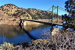
tracks, which ran through the Feather River valley and would be inundated by the future reservoir. As California State Route 162's route also placed it within the proposed Lake Oroville area, construction began on the New Bidwell Bar Bridge
crossing the canyon of the Middle Fork Feather River, which in a decade would be inundated by the rising waters of Lake Oroville. The bridge was not completed until 1965; for several years, it stood over 600 feet (182.9 m) above the river as construction on the dam began.
Official groundbreaking of the dam was in 1961, with dynamite charges set off to clear the canyon walls of obstructions. A low earthen cofferdam
was constructed to keep the river out of the construction site, and the water was diverted into two tunnels around the area. The 128 ft (39 m) high concrete core of the dam, also serving as protection against floods, was built first. After the foundations were complete, engineers identified sources of soil and rock fill that would be used for the construction of the main dam. A large part of the fill came from massive piles of debris left behind by intensive hydraulic mining
during the California Gold Rush
in the mid-19th century. To bring the material to the dam site, a special 11 miles (17.7 km) railway was constructed, and trains ran busily along the line, transporting 120 carloads of dirt every hour.
Thirty-five people died while building the Oroville Dam, many because of the dangers associated with the heavy equipment used in the construction site. In December 1964, heavy rainstorms that caused record flood levels in rivers all over California caused the Feather River to flood, nearly destroying the Oroville Dam site, but the diversion tunnels were able to pass just enough flow to keep the cofferdam from overtopping before the inflow decreased. However, the largest and costliest tragedy that occurred as the dam rose was a train collision on October 7, 1965. Two trains – one heading southwards from the Oroville Dam site, having unloaded its cargo of earthfill, the other rolling north along the line with a full load of dirt and rocks – collided at the south entrance of a tunnel along the Feather River rail line. The southbound locomotive crashed into the northbound and ran over the front of it, and the thousands of gallons of diesel fuel inside created an enormous explosion. Four people were killed in the crash.
Fortunately, no other accidents on a remotely similar scale ever occurred again during construction of the dam. Afterwards, the trains operated without incident; the dam was finally completed on October 6, 1967 after the pouring of 41,315 trainloads of material. As Lake Oroville began to fill, construction commenced on the dam's spillway and its hydroelectric plant, the Edward Hyatt Powerplant. The spillway was finished in 1968, and drilling of the underground facility was completed two years later in 1970.
The dam originally cost $187.8 million to build; however, as a result of the multi-purpose nature of the dam (designed to provide water supply, flood control, power generation, and fish and wildlife enhancement), the total costs were $563.8 million. It took another two years for the cleanup to be completed.
, the reservoir formed behind the dam, has a capacity of 3537577 acre.ft, and is fed by the North Fork Feather River
, Middle Fork Feather River
, West Branch Feather River
and South Fork Feather River
. Of these, the North Fork is the largest contributor, with an average annual discharge rate of over 2150 cuft/s.
The dam's power plant has six generators which are fed by water from intakes on Lake Oroville. Three of these are conventional hydroelectric turbines and the other three comprise the dam's pumping-generating
capability. During times of low power demand, large pumps take water from the Feather River below the Oroville Dam and push it back into Lake Oroville. During peak power demand, the flow is reversed to generate electricity. The nameplate capacity of Oroville's hydroelectric plant is 645 MW, slightly less than the Shasta Dam, which produces 676 MW.
The Oroville Dam is operated in conjunction with the downstream Oroville-Thermalito Complex
, which consists of a complex series of small dams, diversions, pumps, and generators built in and around the Feather River. Directly below the dam lies Thermalito Diversion Pool, from which water is diverted through a canal to irrigate agricultural fields in the Feather River valley and to supply the Thermalito Forebay and Thermalito Afterbay. Power is generated from the drop in elevation between the first two reservoirs and from the latter into the Feather River. The electricity generated from the complex brings the total amount of power produced by Oroville facilities to 760 megawatts.
Because of the Feather River's high fluctuations in flow, releases from Oroville Dam are coordinated so as to maintain a stable flow in the Feather River below the dam as much as possible. The drainage basin of the Feather above Oroville Dam comprises nearly two-thirds of the total watershed. Typically, the reservoir is kept at a high elevation throughout the summer and drawn down by at least a third of capacity in the winter in preparation for floods. Winter storms and spring snowmelt then replenish Lake Oroville, filling the reservoir; in this way floodwater is trapped behind the dam for later releases during the summer low water season. During severe storm events, however, such as the winter of 1996-97, the dam's spillway must be opened, potentially causing flooding downstream.
The Oroville Projects powerplant (Edward Hyatt Powerplant) works in tandem with another nearby power facility, Thermalito Pumping-Generating Plant; together they have a licensed hydro-power capacity of 760 MW and actually produce around 2.2 billion kWh of energy annually.
6.1 earthquake
occurred near Oroville, that the dam sits on top of an active faultline. This caused serious questions to be asked regarding the Auburn Dam
which was just beginning construction at the time and was never built as a result of the possible geologic risk.
Feather River
The Feather River is the principal tributary of the Sacramento River, in the Sacramento Valley of Northern California. The river's main stem is about long. Its length to its most distant headwater tributary is about . Its drainage basin is about...
about 5 miles (8 km) northeast of the city of Oroville, California
Oroville, California
Oroville is the county seat of Butte County, California. The population was 15,506 at the 2010 census, up from 13,004 at the 2000 census...
. It forms Lake Oroville
Lake Oroville
Lake Oroville, also known as Lake Edmonston, is a reservoir in the U.S. state of California, formed by the Oroville Dam across the Feather River. The lake is situated in the foothills of the Sierra Nevada about northeast of Oroville. At over , it is one of the largest reservoirs in California,...
, which stores water for irrigation
Irrigation
Irrigation may be defined as the science of artificial application of water to the land or soil. It is used to assist in the growing of agricultural crops, maintenance of landscapes, and revegetation of disturbed soils in dry areas and during periods of inadequate rainfall...
, flood control
Flood control
In communications, flood control is a feature of many communication protocols designed to prevent overwhelming of a destination receiver. Such controls can be implemented either in software or in hardware, and will often request that the message be resent after the receiver has finished...
, municipal water supply and hydroelectricity
Hydroelectricity
Hydroelectricity is the term referring to electricity generated by hydropower; the production of electrical power through the use of the gravitational force of falling or flowing water. It is the most widely used form of renewable energy...
generation in California's Sacramento Valley
Sacramento Valley
The Sacramento Valley is the portion of the California Central Valley that lies to the north of the San Joaquin-Sacramento Delta in the U.S. state of California. It encompasses all or parts of ten counties.-Geography:...
. The dam lies in the foothills of the Sierra Nevada, and at 770 feet (234.7 m) tall, is the tallest dam in the United States. It powers the third largest hydroelectric plant in California, after the Castaic
Castaic Dam
Castaic Dam is a dam near the city of Castaic, California. It is an earth-fill dam, though its surfaces are covered with boulders and cobble-sized rocks to prevent erosion. Although located on Castaic Creek and forming Castaic Lake, Castaic Creek provides little of its water. The lake is the...
and Shasta Dam
Shasta Dam
Shasta Dam is an arch dam across the Sacramento River in the northern part of the U.S. state of California, at the north end of the Sacramento Valley. The dam mainly serves long-term water storage and flood control in its reservoir, Shasta Lake, and also generates hydroelectric power...
s.
Consensus for the dam started in the early part of the 20th century with the growing irrigation needs of the Central Valley. The Feather, Sacramento
Sacramento River
The Sacramento River is an important watercourse of Northern and Central California in the United States. The largest river in California, it rises on the eastern slopes of the Klamath Mountains, and after a journey south of over , empties into Suisun Bay, an arm of the San Francisco Bay, and...
and other rivers flow through the vast basin, providing water for thousands of acres of fertile farmland. However, California's unreliable precipitation caused serious droughts in some years and severe floods in others. During the Great Depression
Great Depression
The Great Depression was a severe worldwide economic depression in the decade preceding World War II. The timing of the Great Depression varied across nations, but in most countries it started in about 1929 and lasted until the late 1930s or early 1940s...
in the 1930s, plans for two federal water management projects, the U.S. Army Corps of Engineers' California State Water Project
California State Water Project
The California State Water Project, commonly known as the SWP , is the world's largest publicly built and operated water and power development and conveyance system. The SWP was designed and is operated by the California Department of Water Resources...
(SWP), and the U.S. Bureau of Reclamation's Central Valley Project
Central Valley Project
The Central Valley Project is a Bureau of Reclamation federal water project in the U.S. state of California. It was devised in 1933 in order to provide irrigation and municipal water to much of California's Central Valley—by regulating and storing water in reservoirs in the water-rich northern...
(CVP), arose.
During surveys in the 1950s, Oroville and Shasta Dams were identified as key facilities for water management in California
Water in California
California’s interconnected water system serves over 30 million people and irrigates over of farmland. As the world’s largest, most productive, and most controversial water system, it manages over of water per year.- Sources of water :...
, because of their capability to control the flow of California's largest river system, the Sacramento. Oroville became the primary feature of the State Water Project, and construction started in 1961. In 1964, a major flood tore through the Oroville Dam site, further demonstrating the need of the project; one year later, a massive train crash occurred along the rail line used to transport materials to the dam site. Despite damages, the dam was finished in 1968, creating the second largest reservoir in California (after Shasta).
Despite its multiple benefits, the dam has heavily hurt the ecosystem of the Feather River, especially because it blocks migrations of chinook salmon
Chinook salmon
The Chinook salmon, Oncorhynchus tshawytscha, is the largest species in the pacific salmon family. Other commonly used names for the species include King salmon, Quinnat salmon, Spring salmon and Tyee salmon...
and steelhead trout, which once thrived in great abundance in the Sacramento watershed. Construction of the dam has also reduced the flow fluctuations between spring and autumn in the Feather that once were responsible for rearranging sediments and clearing old growth on the riverbanks; it has indirectly led to environmental impacts by promoting heavy development of agricultural and urban areas.
Background
The Central Valley of California has been the state's most important agricultural region throughout its history, especially in the fertile and water-rich southern Sacramento Valley. Three major rivers, the Sacramento, Feather and AmericanAmerican River
The American River is a California watercourse noted as the site of Sutter's Mill, northwest of Placerville, California, where gold was found in 1848, leading to the California Gold Rush...
, flow through the valley, providing water to the flourishing irrigated lands around them. However, historically the rivers were known for intense flow fluctuations – in some years, floods would inundate the valley, destroying crops, killing people and livestock, spreading waterborne disease and causing property damage – while in others severe droughts would cause bad harvests and starvation.
A majority of California's precipitation falls in the north, and as a result the south is more parched and arid. However, the milder climate of the south has attracted people to live there, and in the beginning of the 20th century the Los Angeles Aqueduct
Los Angeles Aqueduct
The Los Angeles Aqueduct system comprising the Los Angeles Aqueduct and the Second Los Angeles Aqueduct, is a water conveyance system operated by the Los Angeles Department of Water and Power...
was built, bringing water to thirsty Southern California
Southern California
Southern California is a megaregion, or megapolitan area, in the southern area of the U.S. state of California. Large urban areas include Greater Los Angeles and Greater San Diego. The urban area stretches along the coast from Ventura through the Southland and Inland Empire to San Diego...
. However, the capacity of the aqueduct was not sufficient to sustain the growing population of the area for long. As a result cities in the south looked to the abundant rivers of the north to draw their water supply from; however, the sheer distance of the water from the people made diversions on a less than statewide scale practically impossible.
Proposals and consensus
Northern California's water resources were first thoroughly studied in 1873 by Colonel B.S. Alexander of the U.S. Army Corps of Engineers. Alexander compiled a report detailing the drainage areas, discharges and hydrography of major Northern California rivers, specifically the Sacramento and the Feather, the state's first and fifth largest rivers by discharge, respectively. During the late 19th century and early-to-mid-20th century, public opinion for a dam increased with the occurrence of major floods and droughts. A large dam like Oroville could impound rainy-season water, thereby preventing floods, and release it during the dry season, thereby moderating the effects of droughts and providing a stable year-round flow.In the 1930s, a bill was passed in Congress allowing construction of facilities of the Central Valley Project
Central Valley Project
The Central Valley Project is a Bureau of Reclamation federal water project in the U.S. state of California. It was devised in 1933 in order to provide irrigation and municipal water to much of California's Central Valley—by regulating and storing water in reservoirs in the water-rich northern...
, a water management project for the Central Valley designed by the U.S. Bureau of Reclamation. By 1940 there was growing pressure for a dam on the Feather River and the construction of an aqueduct to the south.The Burns-Porter Act or California Water Resources Development Bond Act was proposed in 1960 and barely went through by a slim margin – Northern Californians generally opposed the bill because they were afraid that their water supplies were being "stolen" by Southern Californians. Engineer Donald Thayer of the California Department of Water Resources
California Department of Water Resources
The California Department of Water Resources , is a department within the California Natural Resources Agency. The Department of Water Resources is responsible for the State of California's management and regulation of water usage...
was commissioned to design a dam on the Feather River at Oroville. Despite frequent floods and opposition from area residents, construction work on Oroville Dam started in 1961.
Construction
Western Pacific Railroad
The Western Pacific Railroad was a Class I railroad in the United States. It was formed in 1903 as an attempt to break the near-monopoly the Southern Pacific Railroad had on rail service into northern California...
tracks, which ran through the Feather River valley and would be inundated by the future reservoir. As California State Route 162's route also placed it within the proposed Lake Oroville area, construction began on the New Bidwell Bar Bridge
Bidwell Bar Bridge
The Bidwell Bar Bridge, in Oroville, California, refers to two suspension bridges which cross different parts of Lake Oroville. The original Bidwell Bar Bridge was the first steel suspension bridge in California. The $35,000, 240-foot long original was completed in December 1855, and was built of...
crossing the canyon of the Middle Fork Feather River, which in a decade would be inundated by the rising waters of Lake Oroville. The bridge was not completed until 1965; for several years, it stood over 600 feet (182.9 m) above the river as construction on the dam began.
Official groundbreaking of the dam was in 1961, with dynamite charges set off to clear the canyon walls of obstructions. A low earthen cofferdam
Cofferdam
A cofferdam is a temporary enclosure built within, or in pairs across, a body of water and constructed to allow the enclosed area to be pumped out, creating a dry work environment for the major work to proceed...
was constructed to keep the river out of the construction site, and the water was diverted into two tunnels around the area. The 128 ft (39 m) high concrete core of the dam, also serving as protection against floods, was built first. After the foundations were complete, engineers identified sources of soil and rock fill that would be used for the construction of the main dam. A large part of the fill came from massive piles of debris left behind by intensive hydraulic mining
Hydraulic mining
Hydraulic mining, or hydraulicking, is a form of mining that uses high-pressure jets of water to dislodge rock material or move sediment. In the placer mining of gold or tin, the resulting water-sediment slurry is directed through sluice boxes to remove the gold.-Precursor - ground...
during the California Gold Rush
California Gold Rush
The California Gold Rush began on January 24, 1848, when gold was found by James W. Marshall at Sutter's Mill in Coloma, California. The first to hear confirmed information of the gold rush were the people in Oregon, the Sandwich Islands , and Latin America, who were the first to start flocking to...
in the mid-19th century. To bring the material to the dam site, a special 11 miles (17.7 km) railway was constructed, and trains ran busily along the line, transporting 120 carloads of dirt every hour.
Thirty-five people died while building the Oroville Dam, many because of the dangers associated with the heavy equipment used in the construction site. In December 1964, heavy rainstorms that caused record flood levels in rivers all over California caused the Feather River to flood, nearly destroying the Oroville Dam site, but the diversion tunnels were able to pass just enough flow to keep the cofferdam from overtopping before the inflow decreased. However, the largest and costliest tragedy that occurred as the dam rose was a train collision on October 7, 1965. Two trains – one heading southwards from the Oroville Dam site, having unloaded its cargo of earthfill, the other rolling north along the line with a full load of dirt and rocks – collided at the south entrance of a tunnel along the Feather River rail line. The southbound locomotive crashed into the northbound and ran over the front of it, and the thousands of gallons of diesel fuel inside created an enormous explosion. Four people were killed in the crash.
Fortunately, no other accidents on a remotely similar scale ever occurred again during construction of the dam. Afterwards, the trains operated without incident; the dam was finally completed on October 6, 1967 after the pouring of 41,315 trainloads of material. As Lake Oroville began to fill, construction commenced on the dam's spillway and its hydroelectric plant, the Edward Hyatt Powerplant. The spillway was finished in 1968, and drilling of the underground facility was completed two years later in 1970.
The dam originally cost $187.8 million to build; however, as a result of the multi-purpose nature of the dam (designed to provide water supply, flood control, power generation, and fish and wildlife enhancement), the total costs were $563.8 million. It took another two years for the cleanup to be completed.
Operation
Oroville Dam is a primarily rockfill dam with a smaller concrete core, 770 feet (234.7 m) high from its foundations and 6920 feet (2,109.2 m) long. The dam is a massive structure, containing 77619000 cubic yards (59,343,983.5 m³) of material and attaining a maximum base thickness of 3570 feet (1,088.1 m). Oroville's service spillway is a concrete chute 3500 feet (1,066.8 m) long and 150 feet (45.7 m) wide, controlled by eight sluice gates with a total capacity of 250000 cuft/s. There is also a rarely used emergency spillway immediately adjacent and northwest of the main spillway. Lake OrovilleLake Oroville
Lake Oroville, also known as Lake Edmonston, is a reservoir in the U.S. state of California, formed by the Oroville Dam across the Feather River. The lake is situated in the foothills of the Sierra Nevada about northeast of Oroville. At over , it is one of the largest reservoirs in California,...
, the reservoir formed behind the dam, has a capacity of 3537577 acre.ft, and is fed by the North Fork Feather River
North Fork Feather River
The North Fork Feather River is a watercourse of the northern Sierra Nevada in the U.S. state of California. It flows generally southwards from its headwaters near Lassen Peak to Lake Oroville, a reservoir formed by Oroville Dam in the foothills of the Sierra, where it runs into the Feather River....
, Middle Fork Feather River
Middle Fork Feather River
The Middle Fork Feather River is a major river in Plumas and Butte Counties in the U.S. state of California. Nearly long, it drains about of the rugged northern Sierra Nevada range....
, West Branch Feather River
West Branch Feather River
The West Branch Feather River is a Lake Oroville tributary that flows generally north-to-south in the North Fork Feather Watershed near the watershed's drainage divide with the...
and South Fork Feather River
South Fork Feather River
The South Fork Feather River is a Lake Oroville tributary in the south portion of the Middle Fork Feather Watershed which drains the Little Grass Valley, California and has several reservoirs....
. Of these, the North Fork is the largest contributor, with an average annual discharge rate of over 2150 cuft/s.
The dam's power plant has six generators which are fed by water from intakes on Lake Oroville. Three of these are conventional hydroelectric turbines and the other three comprise the dam's pumping-generating
Pumped-storage hydroelectricity
Pumped-storage hydroelectricity is a type of hydroelectric power generation used by some power plants for load balancing. The method stores energy in the form of water, pumped from a lower elevation reservoir to a higher elevation. Low-cost off-peak electric power is used to run the pumps...
capability. During times of low power demand, large pumps take water from the Feather River below the Oroville Dam and push it back into Lake Oroville. During peak power demand, the flow is reversed to generate electricity. The nameplate capacity of Oroville's hydroelectric plant is 645 MW, slightly less than the Shasta Dam, which produces 676 MW.
The Oroville Dam is operated in conjunction with the downstream Oroville-Thermalito Complex
Oroville-Thermalito Complex
The Oroville-Thermalito Complex is a group of facilities and structures located in and around the city of Oroville, California. The complex serves as the headwaters for, and therefore is the most vital facility of, the California Department of Water Resources' State Water Project, the world's...
, which consists of a complex series of small dams, diversions, pumps, and generators built in and around the Feather River. Directly below the dam lies Thermalito Diversion Pool, from which water is diverted through a canal to irrigate agricultural fields in the Feather River valley and to supply the Thermalito Forebay and Thermalito Afterbay. Power is generated from the drop in elevation between the first two reservoirs and from the latter into the Feather River. The electricity generated from the complex brings the total amount of power produced by Oroville facilities to 760 megawatts.
Because of the Feather River's high fluctuations in flow, releases from Oroville Dam are coordinated so as to maintain a stable flow in the Feather River below the dam as much as possible. The drainage basin of the Feather above Oroville Dam comprises nearly two-thirds of the total watershed. Typically, the reservoir is kept at a high elevation throughout the summer and drawn down by at least a third of capacity in the winter in preparation for floods. Winter storms and spring snowmelt then replenish Lake Oroville, filling the reservoir; in this way floodwater is trapped behind the dam for later releases during the summer low water season. During severe storm events, however, such as the winter of 1996-97, the dam's spillway must be opened, potentially causing flooding downstream.
Flood control
Over the past two decades or so the dam has saved an estimated $1.2 billion in flood damage to the surrounding area. During a particularly devastating flood in 1997 Oroville managed to reduce the total peak flow from the storm from 300000 cuft/s to 150000 cuft/s on the dam and flooding on the land below the dam was reduced from 530000 cuft/s to 315000 cuft/s. This resulted in an estimated total savings from that one storm of $1 billion.The Oroville Projects powerplant (Edward Hyatt Powerplant) works in tandem with another nearby power facility, Thermalito Pumping-Generating Plant; together they have a licensed hydro-power capacity of 760 MW and actually produce around 2.2 billion kWh of energy annually.
Earthquake
It was not known until 1975, when a magnitudeRichter magnitude scale
The expression Richter magnitude scale refers to a number of ways to assign a single number to quantify the energy contained in an earthquake....
6.1 earthquake
Earthquake
An earthquake is the result of a sudden release of energy in the Earth's crust that creates seismic waves. The seismicity, seismism or seismic activity of an area refers to the frequency, type and size of earthquakes experienced over a period of time...
occurred near Oroville, that the dam sits on top of an active faultline. This caused serious questions to be asked regarding the Auburn Dam
Auburn Dam
Auburn Dam was a proposed dam on the North Fork of the American River east of the town of Auburn, California in the United States, on the border of Placer and El Dorado Counties. Slated to be completed in the 1970s by the U.S...
which was just beginning construction at the time and was never built as a result of the possible geologic risk.
See also
- California Department of Water Resources (DWR)California Department of Water ResourcesThe California Department of Water Resources , is a department within the California Natural Resources Agency. The Department of Water Resources is responsible for the State of California's management and regulation of water usage...
- Induced seismicityInduced seismicityInduced seismicity refers to typically minor earthquakes and tremors that are caused by human activity that alters the stresses and strains on the Earth's crust. Most induced seismicity is of an extremely low magnitude...
- Lake OrovilleLake OrovilleLake Oroville, also known as Lake Edmonston, is a reservoir in the U.S. state of California, formed by the Oroville Dam across the Feather River. The lake is situated in the foothills of the Sierra Nevada about northeast of Oroville. At over , it is one of the largest reservoirs in California,...
- List of reservoirs and dams in California
- Oroville-Thermalito ComplexOroville-Thermalito ComplexThe Oroville-Thermalito Complex is a group of facilities and structures located in and around the city of Oroville, California. The complex serves as the headwaters for, and therefore is the most vital facility of, the California Department of Water Resources' State Water Project, the world's...
- State Water Project
- List of dams of the United States by height