

Orienteering map
Encyclopedia

Map
A map is a visual representation of an area—a symbolic depiction highlighting relationships between elements of that space such as objects, regions, and themes....
specially prepared for use in orienteering
Orienteering
Orienteering is a family of sports that requires navigational skills using a map and compass to navigate from point to point in diverse and usually unfamiliar terrain, and normally moving at speed. Participants are given a topographical map, usually a specially prepared orienteering map, which they...
competitions. It is a topographic map
Topographic map
A topographic map is a type of map characterized by large-scale detail and quantitative representation of relief, usually using contour lines in modern mapping, but historically using a variety of methods. Traditional definitions require a topographic map to show both natural and man-made features...
with extra details to help the competitor navigate
Navigation
Navigation is the process of monitoring and controlling the movement of a craft or vehicle from one place to another. It is also the term of art used for the specialized knowledge used by navigators to perform navigation tasks...
through the competition area.
These maps are much more detailed than general-purpose topographic maps, and incorporate a standard symbology that is designed to be useful to anyone, regardless of native language. In addition to indicating the topography
Topography
Topography is the study of Earth's surface shape and features or those ofplanets, moons, and asteroids...
of the terrain with contour lines, orienteering maps also show forest density, water features, clearings, trails and roads, earthen banks and rock walls, ditches, wells and pits, fences and power lines, buildings, boulders, and other features of the terrain. Orienteering maps are 1:15 000 or 1:10 000 scale
Scale (map)
The scale of a map is defined as the ratio of a distance on the map to the corresponding distance on the ground.If the region of the map is small enough for the curvature of the Earth to be neglected, then the scale may be taken as a constant ratio over the whole map....
.
Purpose
An orienteering map, and a compassCompass
A compass is a navigational instrument that shows directions in a frame of reference that is stationary relative to the surface of the earth. The frame of reference defines the four cardinal directions – north, south, east, and west. Intermediate directions are also defined...
, are the primary aids for the competitor to complete an orienteering course
Course (orienteering)
An orienteering course is composed of a start point, a series of control points, and a finish point. Controls are marked with a white and orange flag in the terrain, and corresponding purple symbols on an orienteering map...
of control points
Control point (orienteering)
A control point is a marked waypoint used in orienteering and related sports such as rogaining and adventure racing. It is located in the competition area; marked both on an orienteering map and in the terrain; and described on a control description sheet...
as quickly as possible. A map that is reliable and accurate
Accuracy and precision
In the fields of science, engineering, industry and statistics, the accuracy of a measurement system is the degree of closeness of measurements of a quantity to that quantity's actual value. The precision of a measurement system, also called reproducibility or repeatability, is the degree to which...
is essential so that a course can be provided which will test the navigational skills of the competitor. The map also needs to be relevant to the needs of the competitor showing the terrain in neither too much nor too little detail.
Because the competition must test the navigational skills of the competitor, areas are sought which have a terrain that is rich in usable features. In addition, the area should be attractive and interesting. Notable examples in the US include Pawtuckaway State Park
Pawtuckaway State Park
Pawtuckaway State Park is a preserve in New Hampshire, United States. It is one of the largest state parks in southeastern New Hampshire and is named for Pawtuckaway Lake and the Pawtuckaway Mountains...
, New Hampshire
New Hampshire
New Hampshire is a state in the New England region of the northeastern United States of America. The state was named after the southern English county of Hampshire. It is bordered by Massachusetts to the south, Vermont to the west, Maine and the Atlantic Ocean to the east, and the Canadian...
and Valles Caldera, New Mexico
New Mexico
New Mexico is a state located in the southwest and western regions of the United States. New Mexico is also usually considered one of the Mountain States. With a population density of 16 per square mile, New Mexico is the sixth-most sparsely inhabited U.S...
, both having many boulders and boulder fields, and a wide variety of other terrain types.
Orienteering maps are produced by local orienteering clubs and are a valuable resource for the club. Orienteering maps are expensive to produce and the principal costs are: the fieldwork, drawing (cartography), and printing. Each of these can use up valuable resources of a club, be it in manpower or financial costs. Established clubs with good resources e.g. maps and manpower are usually able to host more events.
History
Maps produced specifically for orienteering show a more detailed and up-to-date description of terrain features. For example, large rocks above the soil surface do not normally appear on topographic maps but can be important features on many orienteering maps. New features such as fence lines can be important navigational aids and may also affect route choice. Orienteering maps include these new features.
Cartographer Jan Martin Larsen
Jan Martin Larsen
Jan Martin Larsen is a Norwegian cartographer, orienteer and politician.He graduated from the Norwegian College of Agriculture in 1963, and in his early career he worked in Fjellanger-Widerøe and the Norwegian Ministry of the Environment. From 1986 to 1989 he was the director of mapping in the...
was a pioneer in the development of the specialized orienteering map.
Map content
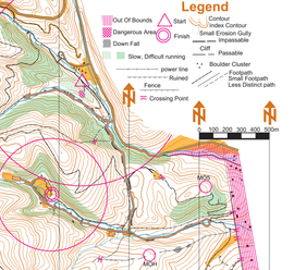
The map scale is 1:15 000, with a permitted enlargement to 1:10 000 (with symbols at 150%). Other map scales may be provided for various purposes, for example Sprint maps use a scale of 1:5 000 or 1:4 000. The map is printed in five colours, which cover the main groups: Land forms, rock and boulders, water and marshMarsh
In geography, a marsh, or morass, is a type of wetland that is subject to frequent or continuous flood. Typically the water is shallow and features grasses, rushes, reeds, typhas, sedges, other herbaceous plants, and moss....
, vegetation, and man-made features. There are additional specifications for technical symbols, and an extra colour for overprinting symbols. The symbols used should be explained in a legend.
Brown: Land forms
Land forms are shown using contour lineContour line
A contour line of a function of two variables is a curve along which the function has a constant value. In cartography, a contour line joins points of equal elevation above a given level, such as mean sea level...
s with a contour interval of 5 metres. Additional symbols are provided to show e.g. earth bank, knoll
Hill
A hill is a landform that extends above the surrounding terrain. Hills often have a distinct summit, although in areas with scarp/dip topography a hill may refer to a particular section of flat terrain without a massive summit A hill is a landform that extends above the surrounding terrain. Hills...
, depression
Depression (geology)
A depression in geology is a landform sunken or depressed below the surrounding area. Depressions may be formed by various mechanisms.Structural or tectonic related:...
, small depression, pit, broken ground etc.
Black: Rock features
This group covers cliffCliff
In geography and geology, a cliff is a significant vertical, or near vertical, rock exposure. Cliffs are formed as erosion landforms due to the processes of erosion and weathering that produce them. Cliffs are common on coasts, in mountainous areas, escarpments and along rivers. Cliffs are usually...
s, boulder
Boulder
In geology, a boulder is a rock with grain size of usually no less than 256 mm diameter. While a boulder may be small enough to move or roll manually, others are extremely massive....
s, boulder fields, and boulder clusters etc.
Blue: Water features
This group covers lakes, ponds, rivers, water channels, marshes, and wells etc.
Green/Yellow: Vegetation
This group covers vegetation. White is typically open runnable forest. Green means a forest of low visibility with reduced running speed, being graded from slow running, through difficult running, to impassable. Yellow colour shows open areas. Green vertical stripes are used to indicate undergrowthUndergrowth
Undergrowth usually refers to the vegetation in a forest, which can obstruct passage through the forest. The height of undergrowth is usually considered to be 0.3 – 3 m . Undergrowth can also refer all vegetation in a forest, which isn't in the canopy....
(slow or difficult running) but otherwise with good visibility.
Black: Man-made features
Man-made features include roads, tracks, paths, power lines, stone walls, fences, buildings, etc.Technical symbols
Two technical symbols are required on all maps: Magnetic north lines printed in blue, and register crosses (these show that the printed colours are coincident).Other map information
Other information is required to be on the printed map although the presentation is not specified, e.g. scale, contour interval and scale bar. Good practice requires information such as date of survey, survey scale, copyright information, and proper credit for the people who produced the map (surveyor, cartographer)..png)
Purple: Overprinting symbols
Symbols are specified so that a course can be overprinted on the map. It includes symbols for the start, control pointsControl point (orienteering)
A control point is a marked waypoint used in orienteering and related sports such as rogaining and adventure racing. It is located in the competition area; marked both on an orienteering map and in the terrain; and described on a control description sheet...
, control numbers, lines between control points, and finish. Extra symbols are available so that information relating to that event may be shown e.g. crossing points, forbidden route, first aid post, and refreshment point etc. These are not permanent features and cannot be included when the map is printed.
Related activities
The International Specification for Orienteering Maps sets out the specifications for orienteering maps for use in foot orienteering, together with specifications for the other sports governed by the International Orienteering FederationInternational Orienteering Federation
The International Orienteering Federation is the international governing body of the sport of orienteering. The IOF head office is located in Helsinki, Finland....
(IOF) i.e. mountain bike orienteering, ski orienteering, and trail orienteering. The specifications are mostly the same but with a few sport specific symbols e.g. ski-o needs to distinguish snow-covered roads from cleared roads.
Mapping process
The mapping processCartography
Cartography is the study and practice of making maps. Combining science, aesthetics, and technique, cartography builds on the premise that reality can be modeled in ways that communicate spatial information effectively.The fundamental problems of traditional cartography are to:*Set the map's...
has four main stages: Creation of the base map, field-work, drawing, and printing.
Base map
The base map can be a topographic mapTopographic map
A topographic map is a type of map characterized by large-scale detail and quantitative representation of relief, usually using contour lines in modern mapping, but historically using a variety of methods. Traditional definitions require a topographic map to show both natural and man-made features...
made for other purposes e.g. mapping from the National Mapping Agency, or a photogrammetric
Photogrammetry
Photogrammetry is the practice of determining the geometric properties of objects from photographic images. Photogrammetry is as old as modern photography and can be dated to the mid-nineteenth century....
plot produced from an aerial survey
Aerial survey
Aerial survey is a geomatics method of collecting information by using aerial photography, LiDAR or from remote sensing imagery using other bands of the electromagnetic spectrum, such as infrared, gamma, or ultraviolet. It can also refer to the chart or map made by analysing a region from the air...
.
As LIDAR
LIDAR
LIDAR is an optical remote sensing technology that can measure the distance to, or other properties of a target by illuminating the target with light, often using pulses from a laser...
-surveying advances, base maps consisting of 1 meter contours and other data derived from the LIDAR data get more common. As these base maps contain large amounts of information the cartographic generalization
Cartographic generalization
Cartographic generalization is the method whereby information is selected and represented on a map in a way that adapts to the scale of the display medium of the map, not necessarily preserving all intricate geographical or other cartographic details...
becomes important in creating a readable map.
Magnetic north
Cartographers use a projectionMap projection
A map projection is any method of representing the surface of a sphere or other three-dimensional body on a plane. Map projections are necessary for creating maps. All map projections distort the surface in some fashion...
to project the curved surface of the earth onto a flat surface. This generates a grid that is used as a base for national topographic mapping. The projection introduces a distortion so that grid north differs from true north; magnetic north is a natural feature that differs from both. As an example: at 52° 35' N 1° 10' E (approx 7 km west of Norwich, England) true north is 2° 33' west of grid north, and magnetic north is about 7° west of grid north. Magnetic north varies continually and in this example (1986) was reducing by about ½° in four years. Orienteering maps are printed using magnetic north and this requires an adjustment to be made to the base map.
Field-work
Field-work is carried out using a small part of the base map fixed to a survey board, covered with a piece of draughting film, and drawn with pencils. The final map needs to be drawn with sufficient accuracy so that a feature shown on the map can be identified clearly on the ground by the competitor, thus, field-workers need to locate features with a high level of accuracy, to ensure consistency between map and terrain. Where the map and terrain are inconsistent, the feature becomes unusable: no control pointControl point (orienteering)
A control point is a marked waypoint used in orienteering and related sports such as rogaining and adventure racing. It is located in the competition area; marked both on an orienteering map and in the terrain; and described on a control description sheet...
can be placed there. Periodic corrections to the map may be necessary, typically vegetation changes in forested areas.
Corrected topographic maps
The earliest orienteering maps used existing topographic maps e.g. United Kingdom Ordnance Survey 1:25 000 plans. These were cut down to a suitable size, corrected by hand, and then copied.Hand-drawn maps
These were initially drawn by hand on tracing paper
Tracing paper
Tracing paper is a type of translucent paper. It is made by immersing uncut and unloaded paper of good quality in sulphuric acid for a few seconds. The acid converts some of the cellulose into amyloid form having a gelatinous and impermeable character. When the treated paper is thoroughly washed...
using one sheet for each of the five colours; the various dot or line screens being added using dry transfer
Dry transfer
Dry transfer is a term used to describe decals which can be applied without the use of water or other solvent. Sometimes they are called rub-ons or rubdowns due to the method of application. The decal itself is on a backing material such as paper or plastic sheeting much like a transparency. The...
screens
Screentone
Screentone is a technique for applying textures and shades to drawings, used as an alternative to hatching. In the conventional process, patterns are transferred to paper from preprinted sheets, but the technique is also simulated in computer graphics...
, for example Letratone manufactured by Letraset
Letraset
Letraset is a company based in the Kingsnorth Industrial Estate in Ashford, Kent, UK.It is known mainly for manufacturing sheets of artwork elements which can be transferred to artwork being prepared. The name Letraset was often used to refer generically to sheets of dry transferrable lettering of...
in the UK. The map was drawn at twice final map scale, and photographically reduced to produce the five film positives for printing. This was a simple process that required very few specialist tools. Draughting film has replaced tracing paper. This is a plastic
Plastic
A plastic material is any of a wide range of synthetic or semi-synthetic organic solids used in the manufacture of industrial products. Plastics are typically polymers of high molecular mass, and may contain other substances to improve performance and/or reduce production costs...
waterproof material etched on one side so that the ink will hold.
Scribed maps
This is the standard process used by National Mapping Agencies. It uses a plastic film, which is coated on one side with a photo-opaque film. The layer is removed with a scribing tool or scalpel to produce a negative image. One sheet of film is needed for each solid colour, and one for each screen, usually requiring about ten sheets of film altogether. The map is drawn at final map scale, and the negatives are printed with high quality dot screens to produce the five film positives for printing. The process makes it easy to produce high quality maps, but it does require a number of specialist tools.
Computer aided maps (digital cartography)
Computer software is available to aid in the drawing of digital maps. OCAD is the leading provider. Other computer software is available that will link with OCAD, or with the digitalDigital
A digital system is a data technology that uses discrete values. By contrast, non-digital systems use a continuous range of values to represent information...
map files, so that courses can be incorporated into the map ready for printing.
Printing
Colour maps were sent to commercial printers for printing in five colours, with the overprinting being added after the map had been printed. This process was chosen as it gave a higher quality for the fine line-work than the industry standard four-colour process (CMYKCMYK color model
The CMYK color model is a subtractive color model, used in color printing, and is also used to describe the printing process itself. CMYK refers to the four inks used in some color printing: cyan, magenta, yellow, and key...
). As computer and software technology has advanced, and the cost reduced, many clubs are now in a position to print their own maps. This enables clubs to print the six colours together (map and overprinting symbols) using that same four-colour process, but with a reduction in quality over traditional printing. Printing costs can be minimised by using standard stock sizes of paper
Paper size
Many paper size standards conventions have existed at different times and in different countries. Today there is one widespread international ISO standard and a localised standard used in North America . The paper sizes affect writing paper, stationery, cards, and some printed documents...
e.g. A4 or Letter
Letter (paper size)
Letter or US Letter is the most common paper size for office use in several countries, including the United States, Canada, Mexico, Bolivia, Colombia, Venezuela, the Philippines, and Chile. It measures 8.5 by 11 inches ....
. It is important to use the correct type of paper: both the weight and the coating affect the usability of the final map.