

Oregon Maneuver
Encyclopedia
The Oregon Maneuver was a large scale military training exercise held in Central Oregon
in 1943. The exercise was designed to test United States Army
units prior to deployment in support of Allied
combat operations in World War II
. The maneuver included approximately 100,000 men. The major units involved in the exercise were all part of the Army’s IV Corps
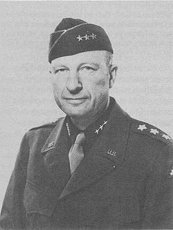
, commanded by Major General
Alexander Patch
. The exercise headquarters was located at Camp Abbot
, south of Bend
, Oregon
. The maneuver included five specific training problems that engaged troops from a defensive Red Force and an offensive Blue Force. Following the maneuver the three participating divisions, the 91st Infantry Division, the 96th Infantry Division, and the 104th Infantry Division were sent into combat in the European
or the Pacific theatre.
. It involved over 100,000 army troops, many of them from Camp Adair
, Camp White
, and combat engineers training center at Camp Abbot. Camp Abbot was used as the exercise headquarters because of its military infrastructure and location near Bend in central Oregon.
The maneuver extended across parts of seven eastern Oregon counties, a total of over 10000 square miles (25,899.9 km²). Almost all of Deschutes County
was included in the maneuver area along with large parts of Crook
, Harney
, Klamath
, and Lake
counties. Small portions of Jefferson
and Grant
counties were also included in the maneuver area. The area included parts of four national forests, the Deschutes National Forest
in the west, the Fremont National Forest
in the southwest, the Ochoco National Forest
in the north and the Malheur National Forest
in the northeast plus vast tracks of land administered by the Bureau of Land Management
throughout the maneuver area. The maneuver area was an irregular triangle shape, with Sisters
in the northwest corner, Burns
in the northeast corner, and Valley Falls
in the south.
The main units participating in the Oregon Maneuver were from the IV Corps, commanded by Major General Alexander M. Patch. The three divisions that made up the IV Corps were the 91st Infantry Division, the 96th Infantry Division, and the 104th Infantry Division. During the exercise the 96th Infantry Division became the core element of the Red Force. The Red Force was commanded by Major General James L. Bradley. The 91st Infantry Division and the 104th Infantry Division were combined to create the Blue Force. The Blue Force was commanded by Major General Gilbert R. Cook
. The Red Force was given the defensive role in the exercise; while the much larger Blue Force conducted offensive operations.
The maneuver plan called for the integration of infantry
, armor
, artillery
, air forces, engineers
, and support units in five specific training problems conducted in nine phases. The specific combat problems included an attack on a consolidated position; an attack and defense of a river line; and an assalt and occupation of defensive positions. Army combat aircraft
were assigned to support the maneuvering ground forces from airfield near Redmond
, Madras
, and Burns. To help simulate the hardships of real combat, each exercise phase was scheduled to run continuously for two to three days.
set up a communication network in the maneuver area.
On 27 July 1943, General Patch and his senior staff arrived at Camp Abbot. The main bodies of infantry arrived in the maneuver area in early August. Most of the infantry units were initially bivouacked along U.S. Route 20
between Sisters and Bend. As the divisions moved to the maneuver area from Camp White and Camp Adair, Oregon state officials warned civilians there would be heavy military traffic crossing the Cascade Mountains over the McKenzie
and Santiam
passes and on U.S. Route 97
. The public was also reminded to obey directions from military police when traveling anywhere in the maneuver area.
 The initial phase of the maneuver was conducted in the triangle between Sisters, Bend, and Redmond. This phase lasted four weeks and focused on combat preparations including live-fire exercises. Army engineers
, many from the engineer training center at Camp Abbot, conducted bridging exercises along the Deschutes River. They also built roads and did other construction work throughout the maneuver area. Medical personnel participated in the maneuver as well, provided on-site medical care to injured and sick troops. As the maneuver got underway, Army logistics troops began working around the clock to move combat supplies, food, water, gasoline, and equipment from a special railhead near Bend to the front lines.
In mid-September, the Red Force deployed to positions 40 miles (64.4 km) east of Bend, establishing a north-south defensive line near Brothers, Oregon
. The Blue Force attacked the line, forcing the Red division to withdraw further east. The Red Force’s new defensive position was approximately 65 miles (104.6 km) east of Bend, near Hampton Mountain. Their defensive line stretched 20 miles (32.2 km) north to south. Again, Blue units attacked the Red line. After several days of stubborn resistance, the Red Force withdrew to the east toward Burns, fighting a delaying action as it pulled back. The Red Force abandoned the town of Burns, withdrawing to positions 30 miles (48.3 km) southwest of the city. The final battle of the Oregon Maneuver was conducted east of Wagontire, Oregon
, near Silver Creek
in Harney County, near where a real battle was fought during the Bannock War
in 1878. The final battle lasted three days, with the Red Force occupying strong positions on high ground blocking U.S. Route 395
. The larger Blue Force used tanks to spearhead their final assault, knocking out one Red outpost after another until the defenders could no longer maintain their line.
The final phase of the maneuver was observed by Lieutenant General
Lesley McNair, chief of United States Army ground forces. During an interview at a dirt airfield near Alkali Lake
, south of the Wagontire battle area, General McNair pronounced the maneuver a success. He also noted that the rugged High Desert
terrain was an exceptionally good training environment for the troops participating in the maneuver. On 13 October 1943, General Patch officially ended the maneuver, declaring that the Red and Blue forces had both accomplished their training missions. The participating units began departing the maneuver area for their home stations in early November 1943. On 9 November 1943, Army officials announced they would repair roads damaged by tanks and other heavy vehicles during the maneuver.
The United States War Department report on the Oregon Maneuver said the high desert environment proved to be ideal for the prescribed training. It noted that "the generally clear, cold weather facilitated long foot marches and permitted almost continuous operations of aircraft." Commanders also found that temperatures could vary by as much as 50 °F (28 °C) in a twenty-four hour period. This tested the troops in a wide variety of conditions. The report stated that the last two exercise problems were conducted when the temperatures were well below freezing
, dropping to 6 °F (-14.4 °C) on some occasions. This was particularly challenging during a river-crossing operation that left participating personnel thoroughly wet; nevertheless, at the end of the maneuver the health of the entire command was found to be excellent.
for staging before participating in combat operations in Italy
. The 96th Infantry Division went to the Hawaii
to prepare for the invasion of the Philippines
. The division participated in the Leyte landing
followed by other combat operations in the Philippines. The division also fought at Okinawa
. The 104th Infantry Division landed in France
on 7 September 1944 and participated in combat operations in northern France, the Rhineland
, and central Germany
.
The only structure built during the Oregon Maneuver to survive for an extended period of time was the General Patch Bridge. The bridge was located on Deschutes National Forest
land within the boundaries of Camp Abbot. The bridge was named for General Alexander M. Patch, commander of the IV Corps, who led the Oregon Maneuver. The Forest Service demolished the bridge in 2008 because the wooden structure had become unsafe.
In 2009, the Oregon Legislature
passed a bill designating the Oregon portion of U.S. Route 97 and parts of Oregon Route 126 as World War II Veterans Historic Highway in recognition of the Oregon Maneuver. The bill notes that the Oregon Maneuver was the largest military training exercise ever held in the Pacific Northwest, involving over 100,000 American soldiers and airmen.
Central Oregon
Central Oregon is a geographic region in the U.S. state of Oregon and is traditionally considered to be made up of Deschutes, Jefferson, and Crook counties. Other definitions include larger areas, often encompassing areas to the north towards the Columbia River, eastward towards Burns, or south...
in 1943. The exercise was designed to test United States Army
United States Army
The United States Army is the main branch of the United States Armed Forces responsible for land-based military operations. It is the largest and oldest established branch of the U.S. military, and is one of seven U.S. uniformed services...
units prior to deployment in support of Allied
Allies of World War II
The Allies of World War II were the countries that opposed the Axis powers during the Second World War . Former Axis states contributing to the Allied victory are not considered Allied states...
combat operations in World War II
World War II
World War II, or the Second World War , was a global conflict lasting from 1939 to 1945, involving most of the world's nations—including all of the great powers—eventually forming two opposing military alliances: the Allies and the Axis...
. The maneuver included approximately 100,000 men. The major units involved in the exercise were all part of the Army’s IV Corps
IV Corps (United States)
The IV Corps replaced the VI Corps in the Fifth United States Army's order of battle in Italy after Allied forces liberated Rome in the summer of 1944 when VI Corps was withdrawn to take part in Operation Dragoon, the Allied invasion of southern France. Initially the Corps had two divisions, U.S...
, commanded by Major General
Major general (United States)
In the United States Army, United States Marine Corps, and United States Air Force, major general is a two-star general-officer rank, with the pay grade of O-8. Major general ranks above brigadier general and below lieutenant general...
Alexander Patch
Alexander Patch
General Alexander McCarrell "Sandy" Patch was an officer in the United States Army, best known for his service in World War II. He commanded Army and Marine forces during the invasion of Guadalcanal, and the U.S...
. The exercise headquarters was located at Camp Abbot
Camp Abbot
Camp Abbot was a United States Army training center located south of Bend, Oregon, United States. The center was used to train combat engineers during World War II. A large part of site has now been developed as Sunriver Resort. The rest has been incorporated into the Deschutes National Forest. ...
, south of Bend
Bend, Oregon
Bend is a city in and the county seat of Deschutes County, Oregon, United States, and the principal city of the Bend, Oregon Metropolitan Statistical Area. Bend is Central Oregon's largest city, and, despite its modest size, is the de facto metropolis of the region, owing to the low population...
, Oregon
Oregon
Oregon is a state in the Pacific Northwest region of the United States. It is located on the Pacific coast, with Washington to the north, California to the south, Nevada on the southeast and Idaho to the east. The Columbia and Snake rivers delineate much of Oregon's northern and eastern...
. The maneuver included five specific training problems that engaged troops from a defensive Red Force and an offensive Blue Force. Following the maneuver the three participating divisions, the 91st Infantry Division, the 96th Infantry Division, and the 104th Infantry Division were sent into combat in the European
European Theatre of World War II
The European Theatre of World War II was a huge area of heavy fighting across Europe from Germany's invasion of Poland on September 1, 1939 until the end of the war with the German unconditional surrender on May 8, 1945...
or the Pacific theatre.
Background
The Oregon Maneuver was the largest military field exercise ever conducted in the Pacific NorthwestPacific Northwest
The Pacific Northwest is a region in northwestern North America, bounded by the Pacific Ocean to the west and, loosely, by the Rocky Mountains on the east. Definitions of the region vary and there is no commonly agreed upon boundary, even among Pacific Northwesterners. A common concept of the...
. It involved over 100,000 army troops, many of them from Camp Adair
Camp Adair
Camp Adair was a United States Army division training facility established north of Corvallis, Oregon, operating from 1942 to 1946. Part of the site is now contained within the E. E...
, Camp White
Camp White
Camp White was an Army training base in Jackson County, Oregon, United States, during World War II. It was also the site of a prisoner-of-war camp. The camp was named in honor of George A. White, who served as adjutant general for Oregon starting in 1915. The camp was dedicated September 15, 1942...
, and combat engineers training center at Camp Abbot. Camp Abbot was used as the exercise headquarters because of its military infrastructure and location near Bend in central Oregon.
The maneuver extended across parts of seven eastern Oregon counties, a total of over 10000 square miles (25,899.9 km²). Almost all of Deschutes County
Deschutes County, Oregon
-National protected areas:* Deschutes National Forest * Newberry National Volcanic Monument-Demographics:As of the census of 2000, there were 115,367 people, 45,595 households, and 31,962 families residing in the county. The population density was 38 people per square mile . There were 54,583...
was included in the maneuver area along with large parts of Crook
Crook County, Oregon
-Demographics:As of the census of 2000, there were 19,182 people, 7,354 households, and 5,427 families residing in the county. The population density was 6 people per square mile . There were 8,264 housing units at an average density of 3 per square mile...
, Harney
Harney County, Oregon
-National protected areas:*Malheur National Forest *Malheur National Wildlife Refuge*Ochoco National Forest -Demographics:As of the census of 2000, there were 7,609 people, 3,036 households, and 2,094 families residing in the county. The population density was 1 people per square mile...
, Klamath
Klamath County, Oregon
-National protected areas:* Bear Valley National Wildlife Refuge* Crater Lake National Park * Deschutes National Forest * Fremont National Forest * Klamath Marsh National Wildlife Refuge* Lower Klamath National Wildlife Refuge...
, and Lake
Lake County, Oregon
Lake County is a county in the high desert south central region of the U.S. state of Oregon, so named for the many lakes found within its boundaries, including Lake Abert, Hart Lake Reservoir, and Goose Lake. While Lake is among Oregon's largest counties, it is sparsely populated with 7,895...
counties. Small portions of Jefferson
Jefferson County, Oregon
Jefferson County is a county located in the U.S. state of Oregon. In 2010, its population was 21,720. It is named after Mount Jefferson. The seat of the county is Madras.-History:...
and Grant
Grant County, Oregon
Grant County is a county located in the U.S. state of Oregon. It is included in the 8 county definition of Eastern Oregon. In 2010, its population was 7,445. It is named for President Ulysses S. Grant, who served as an army officer in the Oregon Territory, and at the time of the county's creation...
counties were also included in the maneuver area. The area included parts of four national forests, the Deschutes National Forest
Deschutes National Forest
The Deschutes National Forest is a United States National Forest located in parts of Deschutes, Klamath, Lake, and Jefferson counties in central Oregon. It comprises 1.8 million acres along the east side of the Cascade mountains. In 1908, the Deschutes National Forest was established from parts...
in the west, the Fremont National Forest
Fremont National Forest
The Fremont National Forest is a United States National Forest named after John C. Frémont, who explored the area for the United States Army Corps of Engineers in 1843. It is located in western Lake and eastern Klamath counties in Oregon, and has a land area of . There are local ranger district...
in the southwest, the Ochoco National Forest
Ochoco National Forest
The Ochoco National Forest is located in Central Oregon in the United States, north and east of the City of Prineville, location of the National Forest Headquarters. It encompasses of rimrock, canyons, geologic oddities, dense pine forests, and high desert terrain, as well as the headwaters of...
in the north and the Malheur National Forest
Malheur National Forest
The Malheur National Forest is a National Forest in the U.S. state of Oregon. It contains 1.7 million acres in the Blue Mountains of eastern Oregon. The forest include high desert grasslands, sage, juniper, pine, fir, and other tree species. Elevations vary from about 4000 feet to the 9038...
in the northeast plus vast tracks of land administered by the Bureau of Land Management
Bureau of Land Management
The Bureau of Land Management is an agency within the United States Department of the Interior which administers America's public lands, totaling approximately , or one-eighth of the landmass of the country. The BLM also manages of subsurface mineral estate underlying federal, state and private...
throughout the maneuver area. The maneuver area was an irregular triangle shape, with Sisters
Sisters, Oregon
Sisters is a city in Deschutes County, Oregon, United States. It is part of the Bend, Oregon Metropolitan Statistical Area. The population was 959 at the 2000 census, but more than doubled to 2038 as of the 2010 census.- History :...
in the northwest corner, Burns
Burns, Oregon
Burns is a city in and the county seat of Harney County, Oregon, United States. As of the 2010 census the population was 2,806.-History:Burns was established in the early 1880s and incorporated upon Harney county's creation in 1889...
in the northeast corner, and Valley Falls
Valley Falls, Oregon
Valley Falls is an unincorporated community in Lake County, Oregon, United States. Valley Falls lies on U.S. Route 395 just south of its junction with Oregon Route 31 near Lake Abert....
in the south.
The main units participating in the Oregon Maneuver were from the IV Corps, commanded by Major General Alexander M. Patch. The three divisions that made up the IV Corps were the 91st Infantry Division, the 96th Infantry Division, and the 104th Infantry Division. During the exercise the 96th Infantry Division became the core element of the Red Force. The Red Force was commanded by Major General James L. Bradley. The 91st Infantry Division and the 104th Infantry Division were combined to create the Blue Force. The Blue Force was commanded by Major General Gilbert R. Cook
Gilbert R. Cook
Gilbert R. Cook was a United States Army general. He had a thirty-six year military career in the United States Army. He served in World War I in France and Germany, commanded the 21st Infantry during the Pearl Harbor attack, and commanded infantry troops in France during World War II.-Early...
. The Red Force was given the defensive role in the exercise; while the much larger Blue Force conducted offensive operations.
The maneuver plan called for the integration of infantry
Infantry
Infantrymen are soldiers who are specifically trained for the role of fighting on foot to engage the enemy face to face and have historically borne the brunt of the casualties of combat in wars. As the oldest branch of combat arms, they are the backbone of armies...
, armor
Armoured fighting vehicle
An armoured fighting vehicle is a combat vehicle, protected by strong armour and armed with weapons. AFVs can be wheeled or tracked....
, artillery
Artillery
Originally applied to any group of infantry primarily armed with projectile weapons, artillery has over time become limited in meaning to refer only to those engines of war that operate by projection of munitions far beyond the range of effect of personal weapons...
, air forces, engineers
Combat engineering
A combat engineer, also called pioneer or sapper in many armies, is a soldier who performs a variety of construction and demolition tasks under combat conditions...
, and support units in five specific training problems conducted in nine phases. The specific combat problems included an attack on a consolidated position; an attack and defense of a river line; and an assalt and occupation of defensive positions. Army combat aircraft
United States Army Air Forces
The United States Army Air Forces was the military aviation arm of the United States of America during and immediately after World War II, and the direct predecessor of the United States Air Force....
were assigned to support the maneuvering ground forces from airfield near Redmond
Redmond, Oregon
Redmond is a city in Deschutes County, Oregon, United States. Incorporated on July 6, 1910, the city is located on the eastern side of Oregon's Cascade Range, in the High Desert, and is considered the geographical heart of Central Oregon...
, Madras
Madras, Oregon
Madras is a city in Jefferson County, Oregon, United States. Originally called The Basin after the circular valley the city is located in, it is unclear as to whether Madras was named in 1903 for the cotton fabric called "Madras" that originated in the Madras area in India, or from the city of...
, and Burns. To help simulate the hardships of real combat, each exercise phase was scheduled to run continuously for two to three days.
Training exercise
Planning for the exercise began in the spring of 1943. By July 1943, preparations for the maneuver were underway in central Oregon. Before training could begin, Army engineers had to complete a number of infrastructure projects including the construction of several airfields. Supply depots were established at key locations and a Signal Corps battalionBattalion
A battalion is a military unit of around 300–1,200 soldiers usually consisting of between two and seven companies and typically commanded by either a Lieutenant Colonel or a Colonel...
set up a communication network in the maneuver area.
On 27 July 1943, General Patch and his senior staff arrived at Camp Abbot. The main bodies of infantry arrived in the maneuver area in early August. Most of the infantry units were initially bivouacked along U.S. Route 20
U.S. Route 20
U.S. Route 20 is an east–west United States highway. As the "0" in its route number implies, US 20 is a coast-to-coast route. Spanning , it is the longest road in the United States, and the route sparsely parallels Interstate 90...
between Sisters and Bend. As the divisions moved to the maneuver area from Camp White and Camp Adair, Oregon state officials warned civilians there would be heavy military traffic crossing the Cascade Mountains over the McKenzie
McKenzie Pass
McKenzie Pass is a mountain pass in the Cascade Range in central Oregon, United States.It is located at the border of Linn and Deschutes counties, approximately 20 mi northwest of Bend, between the Three Sisters to the south and Mt. Washington to the north...
and Santiam
Santiam Pass
Santiam Pass is a mountain pass in the Cascade Range in central Oregon in the United States. It is located on the border between Linn and Jefferson counties, about northwest of Sisters, between the prominent volcanic horns of Three Fingered Jack to the north and Mount Washington to the south...
passes and on U.S. Route 97
U.S. Route 97
U.S. Route 97 is a major north–south United States highway in the western United States. It begins at a junction with Interstate 5 at Weed, California, and travels north, ending in Okanogan County, Washington, at the Canadian Border, across from Osoyoos, British Columbia, becoming British...
. The public was also reminded to obey directions from military police when traveling anywhere in the maneuver area.
United States Army Corps of Engineers
The United States Army Corps of Engineers is a federal agency and a major Army command made up of some 38,000 civilian and military personnel, making it the world's largest public engineering, design and construction management agency...
, many from the engineer training center at Camp Abbot, conducted bridging exercises along the Deschutes River. They also built roads and did other construction work throughout the maneuver area. Medical personnel participated in the maneuver as well, provided on-site medical care to injured and sick troops. As the maneuver got underway, Army logistics troops began working around the clock to move combat supplies, food, water, gasoline, and equipment from a special railhead near Bend to the front lines.
In mid-September, the Red Force deployed to positions 40 miles (64.4 km) east of Bend, establishing a north-south defensive line near Brothers, Oregon
Brothers, Oregon
Brothers is an unincorporated community in Deschutes County, Oregon, United States on U.S. Route 20. It is part of the Bend, Oregon Metropolitan Statistical Area. It lies at an elevation of above sea level.-History:...
. The Blue Force attacked the line, forcing the Red division to withdraw further east. The Red Force’s new defensive position was approximately 65 miles (104.6 km) east of Bend, near Hampton Mountain. Their defensive line stretched 20 miles (32.2 km) north to south. Again, Blue units attacked the Red line. After several days of stubborn resistance, the Red Force withdrew to the east toward Burns, fighting a delaying action as it pulled back. The Red Force abandoned the town of Burns, withdrawing to positions 30 miles (48.3 km) southwest of the city. The final battle of the Oregon Maneuver was conducted east of Wagontire, Oregon
Wagontire, Oregon
Wagontire is an unincorporated community in Harney County, Oregon, United States, on U.S. Route 395. The population has varied recently between zero and two people....
, near Silver Creek
Silver Creek (Harney County, Oregon)
Silver Creek is an stream of Oregon which drains a portion of the endorheic Harney Basin to Harney Lake. Arising in the Blue Mountains, it flows generally southeast, although much of the stream is intermittent...
in Harney County, near where a real battle was fought during the Bannock War
Bannock War
The Bannock War was a series of conflicts in 1878 between various Bannock, Northern Shoshone and Paiute tribes against the United States.- Background :...
in 1878. The final battle lasted three days, with the Red Force occupying strong positions on high ground blocking U.S. Route 395
U.S. Route 395
U.S. Route 395 is a U.S. Route in the western United States. The southern terminus of the route is in the Mojave Desert at Interstate 15 near Hesperia. The northern terminus is at the Canadian border near Laurier, where the road becomes Highway 395 upon entering British Columbia. At one time, the...
. The larger Blue Force used tanks to spearhead their final assault, knocking out one Red outpost after another until the defenders could no longer maintain their line.
The final phase of the maneuver was observed by Lieutenant General
Lieutenant General (United States)
In the United States Army, the United States Air Force and the United States Marine Corps, lieutenant general is a three-star general officer rank, with the pay grade of O-9. Lieutenant general ranks above major general and below general...
Lesley McNair, chief of United States Army ground forces. During an interview at a dirt airfield near Alkali Lake
Alkali Lake (Oregon)
Alkali Lake is a playa in Lake County, Oregon, United States. It is in the Alkali Subbasin of the Summer Lake Basin watershed in southeastern Oregon, located 26 miles east of Christmas Valley, Oregon, northeast of Lake Abert, to the immediate west of Abert Rim and Highway 395.Alkali Lake is...
, south of the Wagontire battle area, General McNair pronounced the maneuver a success. He also noted that the rugged High Desert
High Desert (Oregon)
The Oregon High Desert is a region of the U.S. state of Oregon, located east of the Cascade Range and south of the Blue Mountains, in the central and eastern parts of the state. Divided into a southern region and a northern region, the desert covers most of five Oregon counties and averages above...
terrain was an exceptionally good training environment for the troops participating in the maneuver. On 13 October 1943, General Patch officially ended the maneuver, declaring that the Red and Blue forces had both accomplished their training missions. The participating units began departing the maneuver area for their home stations in early November 1943. On 9 November 1943, Army officials announced they would repair roads damaged by tanks and other heavy vehicles during the maneuver.
The United States War Department report on the Oregon Maneuver said the high desert environment proved to be ideal for the prescribed training. It noted that "the generally clear, cold weather facilitated long foot marches and permitted almost continuous operations of aircraft." Commanders also found that temperatures could vary by as much as 50 °F (28 °C) in a twenty-four hour period. This tested the troops in a wide variety of conditions. The report stated that the last two exercise problems were conducted when the temperatures were well below freezing
Freezing
Freezing or solidification is a phase change in which a liquid turns into a solid when its temperature is lowered below its freezing point. The reverse process is melting....
, dropping to 6 °F (-14.4 °C) on some occasions. This was particularly challenging during a river-crossing operation that left participating personnel thoroughly wet; nevertheless, at the end of the maneuver the health of the entire command was found to be excellent.
Post-exercise
After completing the Oregon training maneuver, the three participating divisions were sent into combat. The 91st Infantry Division was sent to North AfricaNorth Africa
North Africa or Northern Africa is the northernmost region of the African continent, linked by the Sahara to Sub-Saharan Africa. Geopolitically, the United Nations definition of Northern Africa includes eight countries or territories; Algeria, Egypt, Libya, Morocco, South Sudan, Sudan, Tunisia, and...
for staging before participating in combat operations in Italy
Italian Campaign (World War II)
The Italian Campaign of World War II was the name of Allied operations in and around Italy, from 1943 to the end of the war in Europe. Joint Allied Forces Headquarters AFHQ was operationally responsible for all Allied land forces in the Mediterranean theatre, and it planned and commanded the...
. The 96th Infantry Division went to the Hawaii
Hawaii
Hawaii is the newest of the 50 U.S. states , and is the only U.S. state made up entirely of islands. It is the northernmost island group in Polynesia, occupying most of an archipelago in the central Pacific Ocean, southwest of the continental United States, southeast of Japan, and northeast of...
to prepare for the invasion of the Philippines
Philippines
The Philippines , officially known as the Republic of the Philippines , is a country in Southeast Asia in the western Pacific Ocean. To its north across the Luzon Strait lies Taiwan. West across the South China Sea sits Vietnam...
. The division participated in the Leyte landing
Battle of Leyte
The Battle of Leyte in the Pacific campaign of World War II was the invasion and conquest of the island of Leyte in the Philippines by American and Filipino guerrilla forces under the command of General Douglas MacArthur, who fought against the Imperial Japanese Army in the Philippines led by...
followed by other combat operations in the Philippines. The division also fought at Okinawa
Battle of Okinawa
The Battle of Okinawa, codenamed Operation Iceberg, was fought on the Ryukyu Islands of Okinawa and was the largest amphibious assault in the Pacific War of World War II. The 82-day-long battle lasted from early April until mid-June 1945...
. The 104th Infantry Division landed in France
France
The French Republic , The French Republic , The French Republic , (commonly known as France , is a unitary semi-presidential republic in Western Europe with several overseas territories and islands located on other continents and in the Indian, Pacific, and Atlantic oceans. Metropolitan France...
on 7 September 1944 and participated in combat operations in northern France, the Rhineland
Rhineland
Historically, the Rhinelands refers to a loosely-defined region embracing the land on either bank of the River Rhine in central Europe....
, and central Germany
Germany
Germany , officially the Federal Republic of Germany , is a federal parliamentary republic in Europe. The country consists of 16 states while the capital and largest city is Berlin. Germany covers an area of 357,021 km2 and has a largely temperate seasonal climate...
.
The only structure built during the Oregon Maneuver to survive for an extended period of time was the General Patch Bridge. The bridge was located on Deschutes National Forest
Deschutes National Forest
The Deschutes National Forest is a United States National Forest located in parts of Deschutes, Klamath, Lake, and Jefferson counties in central Oregon. It comprises 1.8 million acres along the east side of the Cascade mountains. In 1908, the Deschutes National Forest was established from parts...
land within the boundaries of Camp Abbot. The bridge was named for General Alexander M. Patch, commander of the IV Corps, who led the Oregon Maneuver. The Forest Service demolished the bridge in 2008 because the wooden structure had become unsafe.
In 2009, the Oregon Legislature
Oregon Legislative Assembly
The Oregon Legislative Assembly is the state legislature for the U.S. state of Oregon. The Legislative Assembly is bicameral, consisting of an upper and lower house: the Senate, whose 30 members are elected to serve four-year terms; and the House of Representatives, with 60 members elected to...
passed a bill designating the Oregon portion of U.S. Route 97 and parts of Oregon Route 126 as World War II Veterans Historic Highway in recognition of the Oregon Maneuver. The bill notes that the Oregon Maneuver was the largest military training exercise ever held in the Pacific Northwest, involving over 100,000 American soldiers and airmen.