
Opasatika, Ontario
Encyclopedia
Opasatika is a township
in the Canadian
province of Ontario
, located in the Cochrane District
.
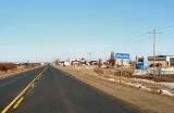
The main communities in the township are Opasatika and Lowther, both located along Highway 11
between Mattice
and Harty
. The ghost town of Reesor Siding
, site of the 1963 Reesor Siding incident
, is at the western edge of the township. The former Canadian Forces Station Lowther
was located in the municipality.
Private dwellings, excluding seasonal cottages: 116 (total: 128)
Mother tongue:
Township (Canada)
The term township generally means the district or area associated with a town. However in some systems no town needs to be involved. The specific use of the term to describe political subdivisions has varied by country, usually to describe a local rural or semi-rural government within the county...
in the Canadian
Canada
Canada is a North American country consisting of ten provinces and three territories. Located in the northern part of the continent, it extends from the Atlantic Ocean in the east to the Pacific Ocean in the west, and northward into the Arctic Ocean...
province of Ontario
Ontario
Ontario is a province of Canada, located in east-central Canada. It is Canada's most populous province and second largest in total area. It is home to the nation's most populous city, Toronto, and the nation's capital, Ottawa....
, located in the Cochrane District
Cochrane District, Ontario
Cochrane District, Ontario is a district and census division in Northeastern Ontario in the Canadian province of Ontario. It was created in 1921 from parts of Timiskaming and Thunder Bay districts....
.
The main communities in the township are Opasatika and Lowther, both located along Highway 11
Highway 11 (Ontario)
King's Highway 11 is a provincially maintained highway in the Canadian province of Ontario. At , it is the second longest highway in the province after Highway 17. Highway 11 begins at Highway 400 in Barrie, and arches through northern Ontario, around Lake Superior, to the Ontario–Minnesota border...
between Mattice
Mattice-Val Côté, Ontario
Mattice-Val Côté is an incorporated township in Cochrane District in Northeastern Ontario, Canada. It is located approximately east of Hearst and west of Kapuskasing on Ontario Highway 11....
and Harty
Val Rita-Harty, Ontario
Val Rita-Harty is a township in the Canadian province of Ontario, located in the Cochrane District.The township consists of two communities, Val Rita and Harty, located along Highway 11 between Opasatika and Kapuskasing...
. The ghost town of Reesor Siding
Reesor, Ontario
Reesor is a ghost town located in Cochrane District, Ontario on the Trans-Canada Highway. It was named after Thomas Reesor , a Mennonite minister from Markham, Ontario, who sponsored and helped to settle new German-speaking Mennonite immigrants from the Soviet Union here around 1925.A school was...
, site of the 1963 Reesor Siding incident
Reesor Siding Strike of 1963
The Reesor Siding Strike of 1963 was one of the defining labour conflicts in Canadian history, resulting in the shooting of 11 union members, three of whom were killed...
, is at the western edge of the township. The former Canadian Forces Station Lowther
CFS Lowther
Canadian Forces Station Lowther is a closed General Surveillance Radar station. It is located east-southeast of Mattice-Val Côté, Ontario...
was located in the municipality.
Demographics
Population:- Population in 2006: 280 (2001 to 2006 population change: -13.8 %)
- Population in 2001: 325
- Population in 1996: 349
- Population in 1991: 388
Private dwellings, excluding seasonal cottages: 116 (total: 128)
Mother tongue:
- English as first language: 12.5 %
- French as first language: 83.9 %
- English and French as first language: 0 %
- Other as first language: 3.6 %