
Onehunga
Encyclopedia
Onehunga is a suburb of Auckland City
, New Zealand
and the location of the Port of Onehunga, the city's small port on the Manukau Harbour
. It is eight kilometres south of the city centre, close to the volcanic
cone of One Tree Hill
, Maungakiekie.
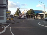
The residential and light-industrial suburb, with its approximately 18,000 residents and almost 1,000 commercial and industrial businesses, stretches south from Royal Oak to the north shore of the Manukau Harbour
. To the east are the areas of Oranga
and Te Papapa
; to the west, Hillsborough
. On the southern shore of the Manukau Harbour and linked to Onehunga by two bridges is the suburb of Mangere Bridge, New Zealand
.
. While most of drinking water of the Auckland area is drawn from reservoirs in the Hunua and Waitakere Ranges, around 5% is drawn from the Onehunga aquifer. The up to 20,000 m³ that are daily drawn from the source receive treatment in a local plant before being fed into the freshwater supply network. In contrast, while the waters of Western Springs
also seep through the city's lava fields, they are no longer used as a source of drinking water.
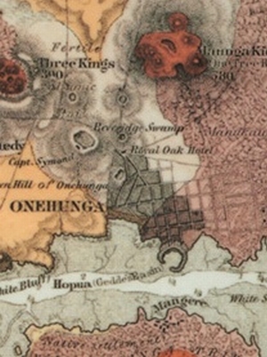
The port area of Onehunga is now much smaller than Auckland's east coast port on the Waitemata Harbour
, although in the 19th century it was the larger. The wharves are located on reclaimed land bordering a low volcanic crater called 'Hopua', once occupied by a tidal lagoon opening to the southwest, but which was also reclaimed.
Onehunga's southwestern side, near the Mangere Harbour, lost its direct waterfront access in the 1970s, when the Southwest Motorway
was built there. Only a tidal lagoon remains on the city side, though as of 2008, there are proposals that the motorway (which is to be widened further) could be sunk into a trench to provide direct access to the harbour again.
and probably means "burial place", referring to the Māori burial caves in the area, probably among the lava flows issuing from One Tree Hill (Maungakiekie). Another possible meaning is "beach" or "sand" for one and "people" for hunga. Onehunga was close to one of the richest areas of the Auckland Isthmus, and saw many battles in pre-European times. In the 1830s decades before the Europeans arrived in larger numbers in the area, the area was the main Ngati Whatua
settlement, who had begun to slowly move back to places north of the Manukau Harbour after the Musket Wars
.
 With the arrival of the Europeans, settlement of the Manukau Harbour
area was begun from and long focused on Onehunga. Raiding of enemy settlements also occurred from here as a base during the Māori Wars. This was due to the town initially having been founded as a fencible
settlement by Governor Grey
, i.e. where former soldiers (mostly Irish) were granted land to settle down, with the implied understanding that if the town was threatened, they would defend it. However, by the time war actually occurred, it was mostly fought with regular soldiers.
During the 19th century most shipping between New Zealand and Great Britain came to Onehunga, via South Africa and Australia. While some shipping entered the Waitemata Harbour
and docked at Auckland, much of it entered the Manukau Heads
and docked at Onehunga, thus saving several days sailing around North Cape.
Onehunga was also the main route to and from the south, as most shipping routes were shorter via the western coast of the North Island than around the east coast to the Waitemata Harbour. Until 1908 a steamer from Onehunga was the fastest means of travel from Auckland to Wellington
, the capital of the colony (initially the sea journey went all the way, then later it connected to the New Plymouth Express
instead). In 1909 a typical coastal freight connection was a steamer from Onehunga to locations like Raglan, Kawhia and Waitara
,
In 1874 the town had 2,044 inhabitants, compared with Wellington's 10,547, reflecting the importance of the smaller port towns during an age when New Zealand was booming, but internal transport links were still rudimentary. In 1876, Onehunga was declared a borough with a mayor and 16 councillors.
From 1885 on, the town became known for its wool industry, which saved it from more serious decline when the shipping trade reduced after 1908. However, it also started to suffer from the toxic discharges the freezing works at Westfield and Southdown pumped into the local part of the harbour.
In 1893 Elizabeth Yates
became mayor
of Onehunga. While she was defeated at the polls only one year later, she was the first woman in the British Empire to hold such a post.
Onehunga had for a short time Auckland's first zoo
. However, the zoological garden that John James Boyd created near today's Royal Oak
did not meet with local approval - mainly due to concerns about the smells and crowds. Ten years after its 1912 opening, the animals were bought and transferred to the new Auckland Zoo
at Western Springs
.
Although the area was a predominantly working-class suburb for much of the 20th century, it has undergone some gentrification
since the 1990s. In recent times, many of the bungalows of the 1920s (along with the earlier villas) have undergone restoration and Dressmart has reinvigorated commerce in the area. Secondary schools located conveniently are Onehunga High School
, One Tree Hill College and Marcellin College
.
The hit TV show Back Of The Y was filmed in 'Auckland's beautiful Onehunga'.
This loss of amenity and space was one of the major complaints of local groups during negotiations over further motorway widening connected to the Mangere Bridge duplication. Proponents of a restored beach eventually won a $18 million commitment from Transit New Zealand (now New Zealand Transport Agency
), which was topped up by a further $10 million from Auckland City Council
. The sum is to fund a large-scale new shoreline west of the motorway, connected to downtown Onehunga with new pedestrian/cyclebridges, and creating 11ha of new beach and headland landscape. Three designs out of seven initial competitors have been shortlisted for further work as of late 2009, and it is hoped to complete the restoration of the foreshore by mid 2014.
In mid 2011, the plans for the restoration works were clarified further, and provided for public comment, setting out a 6.4 hectare reclamation area with sanded beaches, new green opene space and several new headlands. The area is to receive a new boat ramp, and walk and cycleways including a new walking and cycling bridge over the motorway to Onehunga. Construction is now planned to start 2012.
who compete in the Lotto Sport Italia NRFL Premier
.
built by provincial government. Passenger services ran on the line for 100 years until April 1973. A limited number of freight services continued to use the line until 2006 when the line was mothballed. In late 2006 the Government announced approval for $10 million to be spent on reopening the line. Passenger services resumed on 19 September 2010. The Campaign for Better Transport
is currently campaigning to have the line extended south across the proposed new SH20 Manukau Harbour second crossing bridge to Auckland International Airport. Auckland's Mayor Len Brown
has also campaigned for such an airport rail link
, though it will likely only (be able to) happen after a CBD rail link is completed.
Queen St, named after Queen Victoria and renamed Onehunga Mall in the early 1970s, led onto the 1920s Mangere Bridge and thence to the suburb of the same name
. This was one of the main land routes south out of Auckland and the usual route to the airport until the motorway & regional road system in the 1970s diverted the through traffic away from the Onehunga and Mangere Bridge.
Until 1956, a tram line ran all the way from the Auckland CBD
to Onehunga.
Also in Jellicoe Park is a collection of buildings illustrating the early history of the area:
Across Grey Street from the park is
Nearby in Selwyn Street is
Auckland City
Auckland City was the city and local authority covering the Auckland isthmus and most of the islands of the Hauraki Gulf, in the North Island of New Zealand. On 1 November 2010 it was amalgamated into the wider Auckland Region under the authority of the new Auckland Council...
, New Zealand
New Zealand
New Zealand is an island country in the south-western Pacific Ocean comprising two main landmasses and numerous smaller islands. The country is situated some east of Australia across the Tasman Sea, and roughly south of the Pacific island nations of New Caledonia, Fiji, and Tonga...
and the location of the Port of Onehunga, the city's small port on the Manukau Harbour
Manukau Harbour
Manukau Harbour is the second largest natural harbour in New Zealand by area. It is located to the southwest of the Auckland isthmus, and is an arm of the Tasman Sea.-Geography:...
. It is eight kilometres south of the city centre, close to the volcanic
Volcano
2. Bedrock3. Conduit 4. Base5. Sill6. Dike7. Layers of ash emitted by the volcano8. Flank| 9. Layers of lava emitted by the volcano10. Throat11. Parasitic cone12. Lava flow13. Vent14. Crater15...
cone of One Tree Hill
One Tree Hill, New Zealand
One Tree Hill is a 182 metre volcanic peak located in Auckland, New Zealand. It is an important memorial place for both Māori and other New Zealanders...
, Maungakiekie.
The residential and light-industrial suburb, with its approximately 18,000 residents and almost 1,000 commercial and industrial businesses, stretches south from Royal Oak to the north shore of the Manukau Harbour
Manukau Harbour
Manukau Harbour is the second largest natural harbour in New Zealand by area. It is located to the southwest of the Auckland isthmus, and is an arm of the Tasman Sea.-Geography:...
. To the east are the areas of Oranga
Oranga
Oranga is a small residential suburb in Auckland, New Zealand. It is located nine kilometres to the southeast of the city centre, between the commercial suburbs of Te Papapa and Penrose to the south and east, and the residential suburbs of One Tree Hill and Onehunga to the north and south, with...
and Te Papapa
Te Papapa
- to the north-east - to the east - to the south - to the south-west - to the west - to the north-west Penrose Mount Wellington Southdown Favona Mangere Bridge Onehunga...
; to the west, Hillsborough
Hillsborough, Auckland
Hillsborough is an Auckland, New Zealand suburb.Hillsborough is under the local governance of the Auckland City Council. According to the 2001 census, Hillsborough has a population of 9912....
. On the southern shore of the Manukau Harbour and linked to Onehunga by two bridges is the suburb of Mangere Bridge, New Zealand
Mangere Bridge, New Zealand
Mangere Bridge can refer to two places in New Zealand:*Mangere Bridge, New Zealand, a suburb of Auckland City*Mangere Bridge , the bridges that gave the suburb its name...
.
Geography
Onehunga is slightly unusual in that it has a substantial underground freshwater source, the Onehunga aquifer, which it owes to rainwater soaking through the lava flows around One Tree HillOne Tree Hill, New Zealand
One Tree Hill is a 182 metre volcanic peak located in Auckland, New Zealand. It is an important memorial place for both Māori and other New Zealanders...
. While most of drinking water of the Auckland area is drawn from reservoirs in the Hunua and Waitakere Ranges, around 5% is drawn from the Onehunga aquifer. The up to 20,000 m³ that are daily drawn from the source receive treatment in a local plant before being fed into the freshwater supply network. In contrast, while the waters of Western Springs
Western Springs
Western Springs is a residential suburb and park in the west of the city of Auckland in the north of New Zealand. It is located four kilometres to the west of the city centre, situated to the north of State Highway 16....
also seep through the city's lava fields, they are no longer used as a source of drinking water.
The port area of Onehunga is now much smaller than Auckland's east coast port on the Waitemata Harbour
Waitemata Harbour
The quite famous Waitemata Harbour is the main access by sea to Auckland, New Zealand. For this reason it is often referred to as Auckland Harbour, despite the fact that it is only one of two harbours surrounding the city, and is crossed by the Auckland Harbour Bridge. The Waitemata forms the north...
, although in the 19th century it was the larger. The wharves are located on reclaimed land bordering a low volcanic crater called 'Hopua', once occupied by a tidal lagoon opening to the southwest, but which was also reclaimed.
Onehunga's southwestern side, near the Mangere Harbour, lost its direct waterfront access in the 1970s, when the Southwest Motorway
Southwest Motorway
State Highway 20, also known as either the Southwestern Motorway, or the Mangere Motorway, is a New Zealand State Highway linking State Highway 1 at Manukau City Centre with Mount Roskill, via Mangere and Onehunga...
was built there. Only a tidal lagoon remains on the city side, though as of 2008, there are proposals that the motorway (which is to be widened further) could be sunk into a trench to provide direct access to the harbour again.
Māori origins
The name Onehunga is MāoriMaori language
Māori or te reo Māori , commonly te reo , is the language of the indigenous population of New Zealand, the Māori. It has the status of an official language in New Zealand...
and probably means "burial place", referring to the Māori burial caves in the area, probably among the lava flows issuing from One Tree Hill (Maungakiekie). Another possible meaning is "beach" or "sand" for one and "people" for hunga. Onehunga was close to one of the richest areas of the Auckland Isthmus, and saw many battles in pre-European times. In the 1830s decades before the Europeans arrived in larger numbers in the area, the area was the main Ngati Whatua
Ngati Whatua
Ngāti Whātua is a Māori iwi of New Zealand. It consists of four hapu : Te Uri-o-Hau, Te Roroa, Te Taoū, and Ngāti Whātua-o-Ōrākei....
settlement, who had begun to slowly move back to places north of the Manukau Harbour after the Musket Wars
Musket Wars
The Musket Wars were a series of five hundred or more battles mainly fought between various hapū , sometimes alliances of pan-hapū groups and less often larger iwi of Māori between 1807 and 1842, in New Zealand.Northern tribes such as the rivals Ngāpuhi and Ngāti Whātua were the first to obtain...
.
Early European town
Manukau Harbour
Manukau Harbour is the second largest natural harbour in New Zealand by area. It is located to the southwest of the Auckland isthmus, and is an arm of the Tasman Sea.-Geography:...
area was begun from and long focused on Onehunga. Raiding of enemy settlements also occurred from here as a base during the Māori Wars. This was due to the town initially having been founded as a fencible
Fencibles
The Fencibles were army regiments raised in the United Kingdom and in the colonies for defence against the threat of invasion during the American War of Independence and French Revolutionary Wars in the late 18th century...
settlement by Governor Grey
George Grey
George Grey may refer to:*Sir George Grey, 2nd Baronet , British politician*George Grey, 2nd Earl of Kent *Sir George Grey , Governor of Cape Colony, South Australia and New Zealand...
, i.e. where former soldiers (mostly Irish) were granted land to settle down, with the implied understanding that if the town was threatened, they would defend it. However, by the time war actually occurred, it was mostly fought with regular soldiers.
During the 19th century most shipping between New Zealand and Great Britain came to Onehunga, via South Africa and Australia. While some shipping entered the Waitemata Harbour
Waitemata Harbour
The quite famous Waitemata Harbour is the main access by sea to Auckland, New Zealand. For this reason it is often referred to as Auckland Harbour, despite the fact that it is only one of two harbours surrounding the city, and is crossed by the Auckland Harbour Bridge. The Waitemata forms the north...
and docked at Auckland, much of it entered the Manukau Heads
Manukau Heads
The Manukau Heads is the name given to the two promontories that form the entrance to the Manukau Harbour - one of the two harbours of Auckland in New Zealand. The southern head is simply termed "The South Head", whereas the northern head is named "Burnett Head"...
and docked at Onehunga, thus saving several days sailing around North Cape.
Onehunga was also the main route to and from the south, as most shipping routes were shorter via the western coast of the North Island than around the east coast to the Waitemata Harbour. Until 1908 a steamer from Onehunga was the fastest means of travel from Auckland to Wellington
Wellington
Wellington is the capital city and third most populous urban area of New Zealand, although it is likely to have surpassed Christchurch due to the exodus following the Canterbury Earthquake. It is at the southwestern tip of the North Island, between Cook Strait and the Rimutaka Range...
, the capital of the colony (initially the sea journey went all the way, then later it connected to the New Plymouth Express
New Plymouth Express
The New Plymouth Express was a passenger express train operated by the New Zealand Railways Department between Wellington and New Plymouth. It ran from 1886 until 1955 and was sometimes known as the New Plymouth Mail due to the Railway Travelling Post Office carriages included in its consist...
instead). In 1909 a typical coastal freight connection was a steamer from Onehunga to locations like Raglan, Kawhia and Waitara
Waitara, New Zealand
Waitara is the name of a town and a river in the northern part of the Taranaki Region of the North Island of New Zealand. Waitara is located just off State Highway 3, 15 km northeast of New Plymouth....
,
In 1874 the town had 2,044 inhabitants, compared with Wellington's 10,547, reflecting the importance of the smaller port towns during an age when New Zealand was booming, but internal transport links were still rudimentary. In 1876, Onehunga was declared a borough with a mayor and 16 councillors.
From 1885 on, the town became known for its wool industry, which saved it from more serious decline when the shipping trade reduced after 1908. However, it also started to suffer from the toxic discharges the freezing works at Westfield and Southdown pumped into the local part of the harbour.
In 1893 Elizabeth Yates
Elizabeth Yates (mayor)
Elizabeth Yates was the mayor of Onehunga borough in New Zealand for most of 1894. She was the first female mayor anywhere in the British Empire. Onehunga is now part of the city of Auckland.- Life :...
became mayor
Mayor
In many countries, a Mayor is the highest ranking officer in the municipal government of a town or a large urban city....
of Onehunga. While she was defeated at the polls only one year later, she was the first woman in the British Empire to hold such a post.
Merging with Auckland
While in 1891 Onehunga was one of the "25 most populous urban areas/towns of New Zealand", with about 5,000 inhabitants, by the First World War it had ceased to be a port of importance. It gained a new role as a shopping and service centre as it was engulfed by the suburban development of Auckland, and was amalgamated with Auckland City in 1989.Onehunga had for a short time Auckland's first zoo
Zoo
A zoological garden, zoological park, menagerie, or zoo is a facility in which animals are confined within enclosures, displayed to the public, and in which they may also be bred....
. However, the zoological garden that John James Boyd created near today's Royal Oak
Royal Oak, New Zealand
- to the north-east - to the east - to the south-east - to the south - to the south-west - to the west - to the north-west Epsom One Tree Hill Oranga Onehunga...
did not meet with local approval - mainly due to concerns about the smells and crowds. Ten years after its 1912 opening, the animals were bought and transferred to the new Auckland Zoo
Auckland Zoo
Auckland Zoo is a zoological garden in Auckland, New Zealand, situated next to Western Springs park not far from Auckland's central business district. It is run by the Auckland City Council with the Auckland Zoological Society as a supporting organisation....
at Western Springs
Western Springs
Western Springs is a residential suburb and park in the west of the city of Auckland in the north of New Zealand. It is located four kilometres to the west of the city centre, situated to the north of State Highway 16....
.
Although the area was a predominantly working-class suburb for much of the 20th century, it has undergone some gentrification
Gentrification
Gentrification and urban gentrification refer to the changes that result when wealthier people acquire or rent property in low income and working class communities. Urban gentrification is associated with movement. Consequent to gentrification, the average income increases and average family size...
since the 1990s. In recent times, many of the bungalows of the 1920s (along with the earlier villas) have undergone restoration and Dressmart has reinvigorated commerce in the area. Secondary schools located conveniently are Onehunga High School
Onehunga High School
Onehunga High School is a state co-educational secondary school in the Auckland suburb of Onehunga, New Zealand.The school incorporates a business school, founded by Just Water International's creator Tony Falkenstein, which is sponsored by brewery company Lion Nathan and a construction school...
, One Tree Hill College and Marcellin College
Marcellin College, Auckland
Marcellin College is an integrated, co-educational college in Royal Oak, Auckland, New Zealand for students in Year 7 to Year 13. Marcellin College was founded by the Marist Brothers in 1958 as a secondary school for boys only. The school is located on spacious grounds which were formerly part of...
.
The hit TV show Back Of The Y was filmed in 'Auckland's beautiful Onehunga'.
Foreshore
Onehunga's shore is heavily modified by human use. The old volcanic basin that used to link to the Manukau Harbour was filled in, with shorelines reclaimed and straightened for human use (Port of Onehunga, industrial uses and sports fields). Later on, the New Zealand State Highway 20 extension further disrupted Onehunga's connection to the shore in the 1970s.This loss of amenity and space was one of the major complaints of local groups during negotiations over further motorway widening connected to the Mangere Bridge duplication. Proponents of a restored beach eventually won a $18 million commitment from Transit New Zealand (now New Zealand Transport Agency
New Zealand Transport Agency
The New Zealand Transport Agency is a New Zealand Crown entity tasked with promoting safe and functional transport by land, including the responsibility for driver and vehicle licensing and investigating rail accidents. It was created on 1 August 2008 by the Land Transport Management Amendment...
), which was topped up by a further $10 million from Auckland City Council
Auckland City Council
Auckland City Council was the local government authority representing Auckland City, New Zealand, and was amalgamated into the Auckland Council on 1 November 2010. It was an elected body representing the 404,658 residents of the city...
. The sum is to fund a large-scale new shoreline west of the motorway, connected to downtown Onehunga with new pedestrian/cyclebridges, and creating 11ha of new beach and headland landscape. Three designs out of seven initial competitors have been shortlisted for further work as of late 2009, and it is hoped to complete the restoration of the foreshore by mid 2014.
In mid 2011, the plans for the restoration works were clarified further, and provided for public comment, setting out a 6.4 hectare reclamation area with sanded beaches, new green opene space and several new headlands. The area is to receive a new boat ramp, and walk and cycleways including a new walking and cycling bridge over the motorway to Onehunga. Construction is now planned to start 2012.
Sport
Onehunga is home to Onehunga SportsOnehunga Sports
Onehunga Sports is a semi-professional football club in Onehunga, New Zealand. They compete in the Lotto Sport Italia NRFL Premier.-Club history:...
who compete in the Lotto Sport Italia NRFL Premier
Northern League (New Zealand)
The Northern Region Football League, or Lotto Sport Italia NRFL Premier for sponsorship reasons, is a professional/semi-professional New Zealand association football league competition that is run by the...
.
Transport
The Onehunga branch railway line opened in 1873 and was one of the first railways in New ZealandNew Zealand
New Zealand is an island country in the south-western Pacific Ocean comprising two main landmasses and numerous smaller islands. The country is situated some east of Australia across the Tasman Sea, and roughly south of the Pacific island nations of New Caledonia, Fiji, and Tonga...
built by provincial government. Passenger services ran on the line for 100 years until April 1973. A limited number of freight services continued to use the line until 2006 when the line was mothballed. In late 2006 the Government announced approval for $10 million to be spent on reopening the line. Passenger services resumed on 19 September 2010. The Campaign for Better Transport
Campaign for Better Transport
The Campaign for Better Transport is an Auckland, New Zealand, based advocacy group that promotes alternatives to the private car, including public transport, cycling and walking. It is led by convenor Cameron Pitches....
is currently campaigning to have the line extended south across the proposed new SH20 Manukau Harbour second crossing bridge to Auckland International Airport. Auckland's Mayor Len Brown
Len Brown
Len Brown is the Mayor of Auckland in New Zealand and the head of the Auckland Council. He won the 2010 Auckland mayoral election on 9 October 2010 and was sworn in as Mayor of Auckland on 1 November 2010, being the first to hold that title for the amalgamated Auckland 'Super City'...
has also campaigned for such an airport rail link
Airport rail link
An airport rail link is a service providing passenger rail transport from an airport to a nearby city; by mainline- or commuter trains, rapid transit, people mover or light rail...
, though it will likely only (be able to) happen after a CBD rail link is completed.
Queen St, named after Queen Victoria and renamed Onehunga Mall in the early 1970s, led onto the 1920s Mangere Bridge and thence to the suburb of the same name
Mangere Bridge, New Zealand
Mangere Bridge can refer to two places in New Zealand:*Mangere Bridge, New Zealand, a suburb of Auckland City*Mangere Bridge , the bridges that gave the suburb its name...
. This was one of the main land routes south out of Auckland and the usual route to the airport until the motorway & regional road system in the 1970s diverted the through traffic away from the Onehunga and Mangere Bridge.
Until 1956, a tram line ran all the way from the Auckland CBD
Auckland CBD
The Auckland CBD is the geographical and economic heart of the Auckland metropolitan area. Bounded by several major motorways and by the harbour coastline in the north, it is surrounded further out by mostly suburban areas...
to Onehunga.
Notable buildings
- Former Post Office, 1902 John CampbellJohn Campbell (architect)John Campbell was an architect, responsible for many government buildings in New Zealand.Born in Scotland, he travelled to New Zealand in 1882 after training in Glasgow under John Gordon. From 1883 to his retirement in 1922 he worked for the government, holding the title of Government Architect...
Government Architect. Princes Street & Onehunga Mall. One of the earliest examples of the work of this prolific architect.
- Anglican Church of St Peter, Onehunga Mall & Church Sts. The Selwyn church built in 1848 has been relocated, the existing building dates from the 1980s and incorporates a gothic revival tower from the 1930s. The churchyard contains the graves of many of Onehunga's early settlers.
- The Carnegie Free Library in Princes Street opened in 1912. It was one of eighteen in New Zealand built with funds from the American philanthropist Andrew CarnegieAndrew CarnegieAndrew Carnegie was a Scottish-American industrialist, businessman, and entrepreneur who led the enormous expansion of the American steel industry in the late 19th century...
. Its services were eventually absorbed into the public library system and the building has recently been renovated as a restaurant.
- Roman Catholic Church of the Assumption Church & Galway Streets 1889, Thomas Mahoney architect. Once standing in open countryside this is a handsome example of a masonry Gothic church. The cemetery contains the graves of may of Onehunga's early settlers.
- War Memorial Arch, Jellicoe Park, Quadrant Road & Grey Street. Opened in 1923 by the Governor General, Lord Jellicoe, Jellicoe Park is the site of Onehunga's Public Swimming Pools. Near the War Memorial Arch is located the splendid John Park Memorial Fountain which is illuminated on special occasions.
Also in Jellicoe Park is a collection of buildings illustrating the early history of the area:
- The Blockhouse 1859, a brick building relocated from Princes St.
- Journeys End a replica of a wooden 1850 house, relocated here in 1968,
- Laishley House 1859, relocated from Princes St in 1985,
- Selwyn St Settlers Cottage 1850.
Across Grey Street from the park is
- St Peter's Scout Den. This is the 1848 Selwyn Church, relocated here in 1980.
Nearby in Selwyn Street is
- The former Onehunga Primary School 1901, now a community centre this building has been recently restored.
- The former Onehunga railway station building, relocated to 38 Alfred Street, headquarters of the Railway Enthusiasts Society Inc.
External links
- http://onehunga.net.nz Discover Onehunga - all about Onehunga (site maintained by Onehunga Business Association)