
.gif)
Nógrád (former county)
Encyclopedia
Nógrád was the name of a historic administrative county (comitatus
) of the Kingdom of Hungary
. Its territory is presently in southern Slovakia
and in northern present-day Hungary
. The name Novohrad is still used in Slovakia as an informal designation of the corresponding territory. The name stems from the former Nógrád (Novohrad) castle in present-day Hungary.
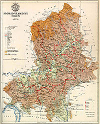 In 1910, Nógrád county shared borders with the counties Hont
, Zólyom (Zvolen), Gömör-Kishont
(Gemer-Malohont), Heves
and Pest-Pilis-Solt-Kiskun
. It was situated approximately along the line Poltár
, Losonc (today Lučenec), Szécsény
and Vác
. The river Ipeľ/Ipoly
flowed through the county. Its area was 4,133 km² around 1910.
, except for the 18th century, when the capital was Lučenec
.
from 1541 to 1595, and from 1605 to 1686, as part of Budin Province
and Egri Province.
In the aftermath of World War I
, the part of Nógrád county north of the river Ipeľ/Ipoly
became part of newly formed Czechoslovakia (as Novohrad county), as recognized by the concerned states in the 1920 Treaty of Trianon
. The southern part stayed in Hungary
. Following the provisions of the controversial First Vienna Award
, the northern half of Novohrad came under Hungarian control in November 1938. After World War II, the Trianon borders were restored. In 1993, Czechoslovakia
dissolved and Novohrad became part of independent Slovakia
. Since 1996, it is part of the Slovak administrative unit Banska Bystrica region
.
The Hungarian part of Nógrád merged with the Hungarian part of Hont
county to form Nógrád-Hont county. Between 1939 and 1945 it was united with the occupied half of the Slovak part of Nógrád county. Since 1950, the Hungarian part of Nógrád, with a small part of former Hont
county added, forms the present Hungarian county Nógrád
.

The towns of Lučenec
and Halič
are presently in Slovakia
.
Comitatus (Kingdom of Hungary)
A county is the name of a type of administrative units in the Kingdom of Hungary and in Hungary from the 10th century until the present day....
) of the Kingdom of Hungary
Kingdom of Hungary
The Kingdom of Hungary comprised present-day Hungary, Slovakia and Croatia , Transylvania , Carpatho Ruthenia , Vojvodina , Burgenland , and other smaller territories surrounding present-day Hungary's borders...
. Its territory is presently in southern Slovakia
Slovakia
The Slovak Republic is a landlocked state in Central Europe. It has a population of over five million and an area of about . Slovakia is bordered by the Czech Republic and Austria to the west, Poland to the north, Ukraine to the east and Hungary to the south...
and in northern present-day Hungary
Hungary
Hungary , officially the Republic of Hungary , is a landlocked country in Central Europe. It is situated in the Carpathian Basin and is bordered by Slovakia to the north, Ukraine and Romania to the east, Serbia and Croatia to the south, Slovenia to the southwest and Austria to the west. The...
. The name Novohrad is still used in Slovakia as an informal designation of the corresponding territory. The name stems from the former Nógrád (Novohrad) castle in present-day Hungary.
Geography
Hont
Hont is the name of a historic administrative county of the Kingdom of Hungary and then shortly of Czechoslovakia...
, Zólyom (Zvolen), Gömör-Kishont
Gömör-Kishont
Gömör-Kishont is the name of a historic administrative county of the Kingdom of Hungary. Its capital was Rimaszombat...
(Gemer-Malohont), Heves
Heves (county)
Heves county lies in northern Hungary. It lies between the right bank of the river Tisza and the Mátra and Bükk mountains. It shares borders with the Hungarian counties Pest, Nógrád, Borsod-Abaúj-Zemplén and Jász-Nagykun-Szolnok...
and Pest-Pilis-Solt-Kiskun
Pest-Pilis-Solt-Kiskun
Pest-Pilis-Solt-Kiskun is the name of a historic administrative county of the Kingdom of Hungary. Its territory is presently in central Hungary, comprising the territory of the present Hungarian county Pest and the northern part of present Bács-Kiskun county...
. It was situated approximately along the line Poltár
Poltár
Poltár is a town and municipality in the Poltár District in the Banská Bystrica Region of Slovakia.-Geography:The town is located in the Southern Slovak basin near the river Ipeľ, south of the Revúcka Hills, which is part of the Slovak Ore Mountains, around from Lučenec.It is home to a small...
, Losonc (today Lučenec), Szécsény
Szécsény
-History :The valley of the Ipoly and especially the area of that around Szécsény was inhabited even in the prehistoric age. Findings attest that the region was peopled from the Neolithic period. Teutons, Avars, and Slavs appeared here in the first millennium BC....
and Vác
Vác
Vác is a town in Pest county in Hungary with approximately 35,000 inhabitants. The archaic spellings of the name are Vacz and Vacs.-Location:...
. The river Ipeľ/Ipoly
Ipel
Ipeľ or Ipoly is a 232 km long river in Slovakia and Hungary, tributary to the river Danube. Its source is in central Slovakia in the Slovenské rudohorie Mountains...
flowed through the county. Its area was 4,133 km² around 1910.
Capitals
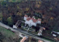
The capital of the county was BalassagyarmatBalassagyarmat
Balassagyarmat is a town in northern Hungary. It was the seat of the Nógrád comitatus.- History :The town's coat-of-arms bears the Latin inscription "Civitas Fortissima" , because in January 1919 Czechoslovak troops crossed the demarcation line delineated in December 1918 in preparation for the...
, except for the 18th century, when the capital was Lučenec
Lucenec
Lučenec is a town in the Banská Bystrica Region of south-central Slovakia. Historically, it was part, and in the 18th century the capital, of the Nógrád county of the Kingdom of Hungary. In 1918, as a result of the Treaty of Trianon, it became a part of Czechoslovakia...
.
History
Nógrád was one of the first counties of the Kingdom of Hungary, founded in the 11th century. It was ruled by the Ottoman EmpireOttoman Empire
The Ottoman EmpireIt was usually referred to as the "Ottoman Empire", the "Turkish Empire", the "Ottoman Caliphate" or more commonly "Turkey" by its contemporaries...
from 1541 to 1595, and from 1605 to 1686, as part of Budin Province
Budin Province, Ottoman Empire
Budin Eyalet was an administrative unit of the Ottoman Empire in Central Europe and the Balkans...
and Egri Province.
In the aftermath of World War I
World War I
World War I , which was predominantly called the World War or the Great War from its occurrence until 1939, and the First World War or World War I thereafter, was a major war centred in Europe that began on 28 July 1914 and lasted until 11 November 1918...
, the part of Nógrád county north of the river Ipeľ/Ipoly
Ipel
Ipeľ or Ipoly is a 232 km long river in Slovakia and Hungary, tributary to the river Danube. Its source is in central Slovakia in the Slovenské rudohorie Mountains...
became part of newly formed Czechoslovakia (as Novohrad county), as recognized by the concerned states in the 1920 Treaty of Trianon
Treaty of Trianon
The Treaty of Trianon was the peace agreement signed in 1920, at the end of World War I, between the Allies of World War I and Hungary . The treaty greatly redefined and reduced Hungary's borders. From its borders before World War I, it lost 72% of its territory, which was reduced from to...
. The southern part stayed in Hungary
Hungary
Hungary , officially the Republic of Hungary , is a landlocked country in Central Europe. It is situated in the Carpathian Basin and is bordered by Slovakia to the north, Ukraine and Romania to the east, Serbia and Croatia to the south, Slovenia to the southwest and Austria to the west. The...
. Following the provisions of the controversial First Vienna Award
First Vienna Award
The First Vienna Award was the result of the First Vienna Arbitration, which took place at Vienna's Belvedere Palace on November 2, 1938. The Arbitration and Award were direct consequences of the Munich Agreement...
, the northern half of Novohrad came under Hungarian control in November 1938. After World War II, the Trianon borders were restored. In 1993, Czechoslovakia
Czechoslovakia
Czechoslovakia or Czecho-Slovakia was a sovereign state in Central Europe which existed from October 1918, when it declared its independence from the Austro-Hungarian Empire, until 1992...
dissolved and Novohrad became part of independent Slovakia
Slovakia
The Slovak Republic is a landlocked state in Central Europe. It has a population of over five million and an area of about . Slovakia is bordered by the Czech Republic and Austria to the west, Poland to the north, Ukraine to the east and Hungary to the south...
. Since 1996, it is part of the Slovak administrative unit Banska Bystrica region
Banská Bystrica Region
The Banská Bystrica Region is one of the Slovak regions in the country of Slovakia in Europe.-Geography:It is located in the central part of Slovakia and has an area of 9,455 km². The region is prevailingly mountains, with several ranges within the area. The highest of them are the Low Tatras...
.
The Hungarian part of Nógrád merged with the Hungarian part of Hont
Hont
Hont is the name of a historic administrative county of the Kingdom of Hungary and then shortly of Czechoslovakia...
county to form Nógrád-Hont county. Between 1939 and 1945 it was united with the occupied half of the Slovak part of Nógrád county. Since 1950, the Hungarian part of Nógrád, with a small part of former Hont
Hont
Hont is the name of a historic administrative county of the Kingdom of Hungary and then shortly of Czechoslovakia...
county added, forms the present Hungarian county Nógrád
Nógrád
Nógrád is a village in Nógrád County, Hungary.- External links :*...
.
Subdivisions
In the early 20th century, the subdivisions of Nógrád/Novohrad county were:| Districts (járás) | |
|---|---|
| District | Capital |
| Balassagyarmat | Balassagyarmat Balassagyarmat Balassagyarmat is a town in northern Hungary. It was the seat of the Nógrád comitatus.- History :The town's coat-of-arms bears the Latin inscription "Civitas Fortissima" , because in January 1919 Czechoslovak troops crossed the demarcation line delineated in December 1918 in preparation for the... |
| Gács | Gács, SK Slovak language Slovak , is an Indo-European language that belongs to the West Slavic languages .Slovak is the official language of Slovakia, where it is spoken by 5 million people... Halič Halic Halic may refer to:* Halič - a village in Slovakia* Haliç - a village in Turkey* The Golden Horn... |
| Losonc | Losonc, SK Lučenec Lucenec Lučenec is a town in the Banská Bystrica Region of south-central Slovakia. Historically, it was part, and in the 18th century the capital, of the Nógrád county of the Kingdom of Hungary. In 1918, as a result of the Treaty of Trianon, it became a part of Czechoslovakia... |
| Nógrád | Rétság Rétság -Location:Rétság is located north of Budapest on the E77 European main road, halfway between Vác and Balassagyarmat. The town is seated at the border of Cserhát and Börzsöny hills. Its location determines the function of the town.-History:... |
| Salgótarján | Salgótarján Salgótarján Salgótarján is a city with county rights in Nógrád county, north-eastern Hungary.-Location:At the foot of Karancs mountain, in the Cserhát hills, 250 meters above sea level, north-east from Budapest, west from Miskolc... |
| Szécsény | Szécsény Szécsény -History :The valley of the Ipoly and especially the area of that around Szécsény was inhabited even in the prehistoric age. Findings attest that the region was peopled from the Neolithic period. Teutons, Avars, and Slavs appeared here in the first millennium BC.... |
| Szirák | Szirák |
| Urban districts (rendezett tanácsú város) | |
| Losonc, SK Lučenec Lucenec Lučenec is a town in the Banská Bystrica Region of south-central Slovakia. Historically, it was part, and in the 18th century the capital, of the Nógrád county of the Kingdom of Hungary. In 1918, as a result of the Treaty of Trianon, it became a part of Czechoslovakia... |
|
The towns of Lučenec
Lucenec
Lučenec is a town in the Banská Bystrica Region of south-central Slovakia. Historically, it was part, and in the 18th century the capital, of the Nógrád county of the Kingdom of Hungary. In 1918, as a result of the Treaty of Trianon, it became a part of Czechoslovakia...
and Halič
Halic
Halic may refer to:* Halič - a village in Slovakia* Haliç - a village in Turkey* The Golden Horn...
are presently in Slovakia
Slovakia
The Slovak Republic is a landlocked state in Central Europe. It has a population of over five million and an area of about . Slovakia is bordered by the Czech Republic and Austria to the west, Poland to the north, Ukraine to the east and Hungary to the south...
.