

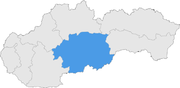
Banská Bystrica Region
Encyclopedia
Regions of Slovakia
Since 1949 , Slovakia has been divided into a number of kraje . Their number, borders and functions have been changed several times. There are currently eight regions of Slovakia and they correspond to the EU's NUTS 3 level of local administrative units. Each kraj consists of okresy...
in the country of Slovakia
Slovakia
The Slovak Republic is a landlocked state in Central Europe. It has a population of over five million and an area of about . Slovakia is bordered by the Czech Republic and Austria to the west, Poland to the north, Ukraine to the east and Hungary to the south...
in Europe
Europe
Europe is, by convention, one of the world's seven continents. Comprising the westernmost peninsula of Eurasia, Europe is generally 'divided' from Asia to its east by the watershed divides of the Ural and Caucasus Mountains, the Ural River, the Caspian and Black Seas, and the waterways connecting...
.
Geography
It is located in the central part of Slovakia and has an area of 9,455 km². The region is prevailingly mountains, with several ranges within the area. The highest of them are the Low Tatras in the north, where the highest point, ĎumbierDumbier
Ďumbier is the highest mountain in the Low Tatra range, in central Slovakia. Despite the remains of medieval mines , the massif is now protected as a part of the Low Tatras National Park....
, is located. Some of the mountain ranges in the west include Kremnica Mountains
Kremnica Mountains
The Kremnica Mountains are a volcanic mountain range in central Slovakia. They are part of the Western Carpathians and the Slovenské stredohorie Mts.The mountain range is situated east of the town of Kremnica, which gave it its name...
, Vtáčnik
Vtácnik
Vtáčnik is a mountain range in central Slovakia, which is part of the Slovenské stredohorie Mountains and part of the Inner Western Carpathians....
and Štiavnica Mountains
Štiavnica Mountains
The Štiavnica Mountains are a volcanic mountain range southern central Slovakia. They are part of Inner Western Carpathians and the Slovenské stredohorie Mountains...
. The Javorie and Krupina Plain ranges are located in the centre. The Slovak Ore Mountains
Slovak Ore Mountains
Slovak Ore Mountains is an extensive mountainous region of Slovakia's Spiš and Gemer region, and in small part in northern Hungary, within the Carpathians. It is the largest mountain range in Slovakia...
are running from the central areas to the east, along with its subdivisions (e.g. Poľana
Polana
Polana may refer to the following places in Poland:*Polana, Lower Silesian Voivodeship *Polana, Bieszczady County in Subcarpathian Voivodeship *Polana, Opole Voivodeship...
, Veporské vrchy, Muránska planina
Muránska planina
Muránska planina is a plateau-like region in central Slovakia, between Brezno, Červená Skala , Muráň and Tisovec...
and Spiš-Gemer Karst
Spiš-Gemer Karst
The Spiš-Gemer Karst is a part in the Slovenské rudohorie Mountains.It consists of these two entities, both of which have been declared national parks:...
). Lower lying areas are located in the south, represented by the Southern Slovak Basin, running along the borders with Hungary
Hungary
Hungary , officially the Republic of Hungary , is a landlocked country in Central Europe. It is situated in the Carpathian Basin and is bordered by Slovakia to the north, Ukraine and Romania to the east, Serbia and Croatia to the south, Slovenia to the southwest and Austria to the west. The...
. Major rivers are the Hron
Hron
Hron is a 298 km long left tributary of the Danube and the second longest river in Slovakia. It flows from its source located in the Low Tatra mountains through central and southern Slovakia, pouring into the Danube near Štúrovo and Esztergom...
in the northern half, Ipeľ
Ipel
Ipeľ or Ipoly is a 232 km long river in Slovakia and Hungary, tributary to the river Danube. Its source is in central Slovakia in the Slovenské rudohorie Mountains...
in the south and centre, Rimava
Rimava
Rimava is a river in southern central Slovakia, which flows only in the Rimavská Sobota District. It is the right tributary of the Slaná river....
and for short length Slaná
Sajó
The Sajó is a river in Slovakia and Hungary.Its length is 229 km, of which 110 km is in Slovakia. Its source is in the Stolica Mountains range of the Slovak Ore Mountains. It flows through the Slovak town Rožňava and the Hungarian city Miskolc. In Hungary it flows through the county of...
in the east. As for administrative division, the region borders Žilina Region
Žilina Region
The Žilina Region is one of the eight Slovak administrative regions and consists of 11 districts .-Geography:It is located in northern Slovakia and has an area of 6,804 km² and a population of 694,763 . The whole area is mountainous, belonging to the Western Carpathians...
in the north, Prešov Region
Prešov Region
The Prešov Region is one of the eight Slovak administrative regions. It consists of 13 districts.-Geography:It is located in north-eastern Slovakia and has an area of 8,975 km². The region has diverse types of landscapes occurring in Slovakia, but mostly highlands and hilly lands dominate the...
in the north-east, Košice Region
Košice Region
The Košice Region is one of the eight Slovak administrative regions. It consists of 11 districts .-Geography:It is located in the southern part of eastern Slovakia and covers an area of 6,752 km²...
in the east, Hungarian Borsod-Abaúj-Zemplén
Borsod-Abaúj-Zemplén
Borsod-Abaúj-Zemplén is the name of an administrative county in north-eastern Hungary , on the border with Slovakia. It shares borders with the Hungarian counties Nógrád, Heves, Hajdú-Bihar and Szabolcs-Szatmár-Bereg. The capital of Borsod-Abaúj-Zemplén county is Miskolc...
county in the south-east, Nógrád
Nógrád (county)
-Description:Nógrád county lies in northern Hungary. It shares borders with Slovakia and the Hungarian counties Pest, Heves and Borsod-Abaúj-Zemplén. The capital of Nógrád county is Salgótarján. Its area is 2544 km²....
county in the south and Pest
Pest (county)
Ethnic groups :*Magyars - 93.5%*Germans - 1.7%*Roma - 1.2%*Slovaks - 0.8%*Others - 0.5%*Unknown - 2.3%Religions :*Roman Catholic - 53%*Calvinist - 16%*Lutheran - 3.8%*Greek Catholic - 1.2%*Others - 1.3%...
county in the south-west, Nitra Region
Nitra Region
The Nitra Region is one of the administrative regions of Slovakia.-Geography:This region with a long history is situated in the southwest of Slovakia, mostly in the eastern part of the Danubian Lowland. It is divided into two sub-units: the Danubian Flat in the south-west, with eastern part of the...
in the west and Trenčín Region
Trencín Region
The Trenčín Region is one of the eight Slovak administrative regions. It consists of 9 districts .-Geography:It is located in the north-western Slovakia, has an area of 4,502 km² and a population of 600,386 . The Danubian Lowland reaches the region to Nové Mesto nad Váhom and Partizánske areas...
in the north-west.
Demographics
The population density in the region is 69.5 inhabitants per km², what is the least of all Slovak regions and much less than country's average (110 per km²). The largest towns are Banská BystricaBanská Bystrica
Banská Bystrica is a key city in central Slovakia located on the Hron River in a long and wide valley encircled by the mountain chains of the Low Tatras, the Veľká Fatra, and the Kremnica Mountains. With 81,281 inhabitants, Banská Bystrica is the sixth most populous municipality in Slovakia...
, Zvolen
Zvolen
Zvolen |Slatina]] rivers, close to Banská Bystrica. With its ancient castle, the town has a historical center, which represents the seat of an okres .-History:...
, Lučenec
Lucenec
Lučenec is a town in the Banská Bystrica Region of south-central Slovakia. Historically, it was part, and in the 18th century the capital, of the Nógrád county of the Kingdom of Hungary. In 1918, as a result of the Treaty of Trianon, it became a part of Czechoslovakia...
and Rimavská Sobota
Rimavská Sobota
Rimavská Sobota is a town in southern Slovakia, in the Banská Bystrica Region, on the Rimava river. It has 24,374 inhabitants . The town is a historical capital of the Gömör-Kishont county .-Geography:...
. According to the 2001 census, there were 662,121 inhabitants in the region, with a majority of Slovaks
Slovaks
The Slovaks, Slovak people, or Slovakians are a West Slavic people that primarily inhabit Slovakia and speak the Slovak language, which is closely related to the Czech language.Most Slovaks today live within the borders of the independent Slovakia...
(83.7%), but there is a Hungarian minority (11.8%) along Hungarian border, and there are small minorities of Roma (2.3%) and Czechs(<1%).
List of districts (okresy)
- Banská Bystrica DistrictBanská Bystrica DistrictBanská Bystrica District is a district in the Banská Bystrica Region of central Slovakia. Until 1918, the area belonged to the county of Zvolen within the Kingdom of Hungary.-Municipalities:*Badín*Baláže*Banská Bystrica*Brusno*Čerín...
- Banská Štiavnica DistrictBanská Štiavnica DistrictBanská Štiavnica District is a district in the Banská Bystrica Region of central Slovakia. Until 1918, most of the present-day district belonged to the Hungarian county of Hont, apart from Močiar and Podhorie in the north and Kozelník in the east .-Municipalities:*Baďan*Banská Belá*Banská...
- Brezno DistrictBrezno DistrictBrezno District is a district inthe Banská Bystrica Region of central Slovakia. Until 1918, most of the present-day district belonged to the Zvolen county, apart from Polomka in the east which was part of the county of Gemer a Malohont....
- Detva DistrictDetva DistrictDetva District is a district of the Banská Bystrica Region in central Slovakia. Until 1918, most of the area belonged to the Zvolen county, apart from Látky, Podkriváň and Horný Tisovník in the south and east which formed part of the county of Nógrád....
- Krupina DistrictKrupina DistrictKrupina District is a district inthe Banská Bystrica Region of central Slovakia. Until 1918, the district was in the Hungarian Hont County.- Municipalities :*Bzovík*Cerovo*Čabradský Vrbovok*Čekovce*Devičie*Dolné Mladonice...
- Lučenec DistrictLucenec DistrictLučenec District is a district in the Banská Bystrica Region of south-central Slovakia. Until 1918, most of the district belong to the Novohrad county, with a small area around the villages of Šíd, Čamovce and Šurice in the east belonging to the Gemer a Malohont county.The district is situated in...
- Poltár DistrictPoltár DistrictPoltár District is a district inthe Banská Bystrica Region of central Slovakia. Until 1918, the district was split between the Hungarian counties of Nógrád and Gemer a Malohont.-Municipalities:*Breznička*Cinobaňa*České Brezovo...
- Revúca DistrictRevúca DistrictRevúca District is a district inthe Banská Bystrica Region of central Slovakia. Until 1918, the district was part of the Hungarian county of Gemer and Malohont.-Municipalities:*Držkovce*Gemer*Gemerská Ves*Gemerské Teplice...
- Rimavská Sobota DistrictRimavská Sobota DistrictRimavská Sobota District is a district in the Banská Bystrica Region of central Slovakia.Until 1918, the district was mostly part of the Hungarian county of Gemer a Malohont, apart from Konrádovce in the south-west which was part of the county of...
- Veľký Krtíš DistrictVelký Krtíš DistrictVeľký Krtíš District is a district inthe Banská Bystrica Region of central Slovakia. Until 1918, the district was split between the Hungarian counties of Hont and Nógrád.-Municipalities:*Balog nad Ipľom*Bátorová*Brusník...
- Zvolen DistrictZvolen DistrictZvolen District is a district inthe Banská Bystrica Region of central Slovakia. Until 1918, most of the present-day district belonged to the Zvolen county, apart from Lešť in the south-west which was part of the county of Gemer a Malohont.- Municipalities :*Babiná*Bacúrov*Breziny*Budča*Bzovská...
- Žarnovica DistrictŽarnovica DistrictŽarnovica District is a district inthe Banská Bystrica Region of central Slovakia. Until 1918, the district was mostly part of the Hungarian county of Tekov, only a part of Hodruša-Hámre, namely Banská Hodruša in the east was part of Banská Štiavnica, an urban county on the territory of Hont...
- Žiar nad Hronom DistrictŽiar nad Hronom DistrictŽiar nad Hronom District is a district in the Banská Bystrica Region of central Slovakia. Until 1918, the district was part of the county of Tekov.- Municipalities :The names in bold represent towns.*Bartošova Lehôtka*Bzenica*Dolná Trnávka...
List of municipalities and towns
There are 513 municipalities, of which 24 are towns (in bold), where the 56% of the region's population live.External links
- Banskobystrický samosprávny kraj Official website