

Nunavik
Encyclopedia
Quebec
Quebec or is a province in east-central Canada. It is the only Canadian province with a predominantly French-speaking population and the only one whose sole official language is French at the provincial level....
, Canada
Canada
Canada is a North American country consisting of ten provinces and three territories. Located in the northern part of the continent, it extends from the Atlantic Ocean in the east to the Pacific Ocean in the west, and northward into the Arctic Ocean...
. Covering a land area of 443,684.71 km² (171,307.62 sq mi) north of the 55th parallel
55th parallel north
The 55th parallel north is a circle of latitude that is 55 degrees north of the Earth's equatorial plane. It crosses Europe, Asia, the Pacific Ocean, North America, and the Atlantic Ocean....
, it is the homeland of the Inuit
Inuit
The Inuit are a group of culturally similar indigenous peoples inhabiting the Arctic regions of Canada , Denmark , Russia and the United States . Inuit means “the people” in the Inuktitut language...
of Quebec. Almost all of the 11,627 inhabitants (2006 census
Statistics Canada
Statistics Canada is the Canadian federal government agency commissioned with producing statistics to help better understand Canada, its population, resources, economy, society, and culture. Its headquarters is in Ottawa....
) of the region, of whom 90% are Inuit
Inuit
The Inuit are a group of culturally similar indigenous peoples inhabiting the Arctic regions of Canada , Denmark , Russia and the United States . Inuit means “the people” in the Inuktitut language...
, live in fourteen northern villages on the coast of Nunavik and in the Cree
Cree
The Cree are one of the largest groups of First Nations / Native Americans in North America, with 200,000 members living in Canada. In Canada, the major proportion of Cree live north and west of Lake Superior, in Ontario, Manitoba, Saskatchewan, Alberta and the Northwest Territories, although...
reserved land (TC) of Whapmagoostui
Whapmagoostui, Quebec
Whapmagoostui |beluga]]") is the northernmost Cree village in Quebec, located at the mouth of the Great Whale River on the coast of Hudson Bay in Nunavik, Quebec, Canada. About 500 people, mostly Inuit, live in the neighbouring northern village of Kuujjuarapik. The community is only accessible by...
, near the northern village of Kuujjuarapik
Kuujjuarapik, Quebec
Kuujjuarapik is the southernmost Inuit village at the mouth of the Great Whale River on the coast of Hudson Bay in Nunavik, Quebec, Canada. About 800 people, mostly Cree, live in the adjacent village of Whapmagoostui. The community is only accessible by air and, in late summer, by boat...
.
Nunavik means "place to live" in the local dialect of Inuktitut
Inuktitut
Inuktitut or Eastern Canadian Inuktitut, Eastern Canadian Inuit language is the name of some of the Inuit languages spoken in Canada...
and the Inuit inhabitants of the region call themselves Nunavimmiut. Until 1912, the region was part of the District of Ungava
District of Ungava
The District of Ungava was a regional administrative district of Canada's Northwest Territories from 1895 to 1912. It covered the northern portion of what is today Quebec, the interior of Labrador and the offshore islands to the west and north, which are now part of the Nunavut.The continental...
of the Northwest Territories
Northwest Territories
The Northwest Territories is a federal territory of Canada.Located in northern Canada, the territory borders Canada's two other territories, Yukon to the west and Nunavut to the east, and three provinces: British Columbia to the southwest, and Alberta and Saskatchewan to the south...
.
Negotiations for regional autonomy are underway, and it is possible that Nunavik will become a self-governing region within the province of Quebec, with outstanding land claims resolved, in 2011. The seat of government is to be Kuujjuaq
Kuujjuaq, Quebec
Kuujjuaq is the largest Inuit village in Nunavik, Quebec, Canada with a population of 2,132 as of the 2006 census. This is up roughly 10% from 1,932 as of the 2001 Census. It is the administrative capital of Nunavik and lies on the western shore of the Koksoak River.Kuujjuaq previously was known...
.
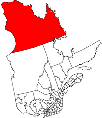
Geography
.jpg)
California
California is a state located on the West Coast of the United States. It is by far the most populous U.S. state, and the third-largest by land area...
, located in the northernmost part of Quebec. It lies in both the Arctic and subarctic climate zones. All together, about 11,000 people live in Nunavik's communities, and this number may be growing.
Nunavik is separated from Nunavut
Nunavut
Nunavut is the largest and newest federal territory of Canada; it was separated officially from the Northwest Territories on April 1, 1999, via the Nunavut Act and the Nunavut Land Claims Agreement Act, though the actual boundaries had been established in 1993...
Territory by Hudson Bay
Hudson Bay
Hudson Bay , sometimes called Hudson's Bay, is a large body of saltwater in northeastern Canada. It drains a very large area, about , that includes parts of Ontario, Quebec, Saskatchewan, Alberta, most of Manitoba, southeastern Nunavut, as well as parts of North Dakota, South Dakota, Minnesota,...
to the west and Hudson Strait
Hudson Strait
Hudson Strait links the Atlantic Ocean to Hudson Bay in Canada. It lies between Baffin Island and the northern coast of Quebec, its eastern entrance marked by Cape Chidley and Resolution Island. It is long...
and Ungava Bay
Ungava Bay
Ungava Bay is a large bay in northeastern Canada separating Nunavik from Baffin Island. The bay is shaped like a rounded square with a side length of about and has an area of approximately...
to the north. Nunavik shares a border with the Côte-Nord
Côte-Nord
Côte-Nord is the second largest administrative region by land area in Quebec, Canada, after Nord-du-Québec...
region of Quebec and the Labrador
Labrador
Labrador is the distinct, northerly region of the Canadian province of Newfoundland and Labrador. It comprises the mainland portion of the province, separated from the island of Newfoundland by the Strait of Belle Isle...
region of the province of Newfoundland and Labrador
Newfoundland and Labrador
Newfoundland and Labrador is the easternmost province of Canada. Situated in the country's Atlantic region, it incorporates the island of Newfoundland and mainland Labrador with a combined area of . As of April 2011, the province's estimated population is 508,400...
. The Ungava Peninsula
Ungava Peninsula
The Ungava Peninsula of Nunavik, Quebec, Canada, is bounded by Hudson Bay to the west, Hudson Strait to the north, and Ungava Bay to the east. The Ungava Peninsula is part of the Labrador Peninsula and covers about 252,000 km²...
forms the northern two-thirds of the region.
Nunavik has fourteen villages, populated by an Inuit
Inuit
The Inuit are a group of culturally similar indigenous peoples inhabiting the Arctic regions of Canada , Denmark , Russia and the United States . Inuit means “the people” in the Inuktitut language...
majority. The principal village and administrative centre in Nunavik is Kuujjuaq
Kuujjuaq, Quebec
Kuujjuaq is the largest Inuit village in Nunavik, Quebec, Canada with a population of 2,132 as of the 2006 census. This is up roughly 10% from 1,932 as of the 2001 Census. It is the administrative capital of Nunavik and lies on the western shore of the Koksoak River.Kuujjuaq previously was known...
, on the southern shore of Ungava Bay; the other villages are Inukjuak
Inukjuak, Quebec
Inukjuak , alternatively spelled Inoucdjouac, former name and current postal name Port Harrison, is an Inuit settlement located on Hudson Bay at the mouth of the Innuksuak River in the Nunavik region of northern Quebec, Canada. Its population is 1,294...
(where the film Nanook of the North
Nanook of the North
Nanook of the North is a 1922 silent documentary film by Robert J. Flaherty. In the tradition of what would later be called salvage ethnography, Flaherty captured the struggles of the Inuk Nanook and his family in the Canadian arctic...
was shot), Salluit
Salluit, Quebec
Salluit is the second northernmost Inuit community in Quebec, Canada, located on Sugluk Inlet close to the Hudson Strait. Its population was 1241 in 2006 , and growing rapidly...
, Puvirnituq
Puvirnituq, Quebec
Puvirnituq is an Inuit settlement in Nunavik on the Povungnituk River near its mouth on the Hudson Bay in northern Quebec, Canada. Its population is 1457 .The name means "Place where there is a smell of rotten meat"...
, Ivujivik
Ivujivik, Quebec
Ivujivik is the northernmost settlement in the Canadian Province of Quebec. It is also the northernmost settlement in any Canadian province...
, Kangiqsujuaq
Kangiqsujuaq, Quebec
Kangiqsujuaq is an Inuit community in Nunavik, Nord-du-Québec, Quebec, Canada. It had a population of 552 in 2006. The community has also been known as Wakeham Bay. The name "Kangiqsujuaq" means "the large bay" in Inuktitut....
, Kangiqsualujjuaq
Kangiqsualujjuaq, Quebec
Kangiqsualujjuaq is an Inuit village with a population of approximately 620, located on the east coast of Ungava Bay at the mouth of the George River, in Nunavik, Quebec, Canada....
, Kangirsuk
Kangirsuk, Quebec
Kangirsuk is an Inuit village in northern Nunavik, Quebec, Canada. It is north of Kuujjuaq, between Aupaluk and Quaqtaq. The community is only accessible by air and, in late summer, by boat...
, Tasiujaq
Tasiujaq, Quebec
Tasiujaq is a community in Quebec, Canada. It was built on the shores of Leaf Lake at the head of Deep Harbour and lies a few kilometres north of the tree line, where the shrub tundra finally gives way to the arctic tundra. Tasiujaq actually refers to the whole of Leaf Basin: Leaf Lake, Leaf...
, Aupaluk
Aupaluk, Quebec
Aupaluk is the smallest Inuit settlement in Nunavik. In 2001, there were 159 residents; the 2006 population of 174 marks a 9.4% increase over these five years. There are 49 private dwellings in the settlement, all occupied by usual residents. The settlement spans 30.12 km² in terms of area and...
, Akulivik
Akulivik, Quebec
Akulivik is an Inuit village in Nunavik, in northern Quebec, Canada. It is located on a peninsula that juts southwesterly into Hudson Bay across from Smith Island...
, Quaqtaq
Quaqtaq, Quebec
Quaqtaq is an Inuit village in Nunavik, northern Quebec, Canada. The village is one of the northernmost inhabited places in Quebec, located on the eastern shore of Diana Bay , on a peninsula which protrudes into the Hudson Strait where it meets Ungava Bay.The name Quaqtaq signifies tapeworm...
, and Umiujaq
Umiujaq, Quebec
Umiujaq is an Inuit village near the eastern shore of Hudson Bay in Nunavik in northern Quebec, Canada. The village was established in 1986 by Inuit from Kuujjuarapik, 160 km to the south, who decided to relocate away from the area affected by the James Bay Hydro-electric Project.Umiujaq,...
. The village population (census 2006) ranges from 2,132 (Kuujjuaq) to 174 (Aupaluk).
There are no road links between Nunavik and southern Quebec, although the Trans-Taiga Road
Route Transtaïga
The Trans-Taiga Road is an extremely remote wilderness road in northern Quebec, Canada. It is long to Centrale Brisay and another along the Caniapiscau Reservoir, all of it unpaved....
of the Jamésie region ends near the 55th parallel on the Caniapiscau Reservoir
Caniapiscau Reservoir
The Caniapiscau Reservoir is a reservoir on the upper Caniapiscau River in the Côte-Nord administrative region of the Canadian province of Quebec...
, several hundred kilometers south of Kuujjuaq. There is a year-round air link to all villages and seasonal shipping in the summer and autumn. Parts of the interior of southern Nunavik can be reached using several trails which head north from Schefferville.
There are three meteor craters in Nunavik: New Quebec crater
New Quebec crater
The Pingualuit Crater , formerly called Chubb Crater and later New Quebec Crater , is a young impact crater, by geological standards, located in the Ungava Peninsula of Quebec, Canada...
, Couture crater
Couture crater
Lac Couture is a lake in Northern Quebec, Canada. It is located in Baie d'Hudson in the Kativik territory.Most of the lake covers an 8 km in diameter impact crater. The crater is estimated to be 430 ± 25 million years old .-External links:*...
, and La Moinerie crater
La Moinerie crater
La Moinerie is an impact crater in Quebec, Canada. It is 8 km in diameter and the age is estimated to be 400 ± 50 million years . The crater is exposed to the surface and filled with water, forming Lac La Moinerie. Glaciers have eroded many of La Moinerie crater's original physical features,...
.
History
Federal government geopolitical manoeuvrings forced several Inuit families to leave Nunavik in the 1950s. They were transported to barren hamlets at Grise FiordGrise Fiord, Nunavut
Grise Fiord, is a small Inuit hamlet in the Qikiqtaaluk Region in the territory of Nunavut, Canada. Despite its low population , it is the largest community on Ellesmere Island...
and Resolute
Resolute, Nunavut
Resolute or Resolute Bay is a small Inuit hamlet on Cornwallis Island in Nunavut, Canada. It is situated at the northern end of Resolute Bay and the Northwest Passage and is part of the Qikiqtaaluk Region....
in what is now Nunavut
Nunavut
Nunavut is the largest and newest federal territory of Canada; it was separated officially from the Northwest Territories on April 1, 1999, via the Nunavut Act and the Nunavut Land Claims Agreement Act, though the actual boundaries had been established in 1993...
in an effort to assert sovereignty in the High Arctic
Arctic
The Arctic is a region located at the northern-most part of the Earth. The Arctic consists of the Arctic Ocean and parts of Canada, Russia, Greenland, the United States, Norway, Sweden, Finland, and Iceland. The Arctic region consists of a vast, ice-covered ocean, surrounded by treeless permafrost...
during the Cold War
Cold War
The Cold War was the continuing state from roughly 1946 to 1991 of political conflict, military tension, proxy wars, and economic competition between the Communist World—primarily the Soviet Union and its satellite states and allies—and the powers of the Western world, primarily the United States...
. Eight Inuit families from Inukjuak, Quebec
Inukjuak, Quebec
Inukjuak , alternatively spelled Inoucdjouac, former name and current postal name Port Harrison, is an Inuit settlement located on Hudson Bay at the mouth of the Innuksuak River in the Nunavik region of northern Quebec, Canada. Its population is 1,294...
(on the Ungava Peninsula
Ungava Peninsula
The Ungava Peninsula of Nunavik, Quebec, Canada, is bounded by Hudson Bay to the west, Hudson Strait to the north, and Ungava Bay to the east. The Ungava Peninsula is part of the Labrador Peninsula and covers about 252,000 km²...
) were relocated after being promised homes and game to hunt, but the relocated people discovered no buildings and very little familiar wildlife. They were told that they would be returned home to Nunavik after a year if they wished, but this offer was later withdrawn as it would damage Canada's claims to sovereignty in the area and the Inuit were forced to stay. Eventually, the Inuit learned the local beluga whale migration routes and were able to survive in the area, hunting over a range of 18,000 km² (6,950 mi²) each year.
In 1993, the Canadian government held hearings to investigate the relocation program. The Royal Commission on Aboriginal Peoples
Royal Commission on Aboriginal Peoples
The Royal Commission on Aboriginal Peoples was a Canadian Royal Commission established in 1991 to address many issues of aboriginal status that had come to light with recent events such as the Oka Crisis and the Meech Lake Accord. The commission culminated in a final report of 4000 pages,...
issued a report the following year entitled The High Arctic Relocation: A Report on the 1953-55 Relocation. The government paid $10 million CAD to the survivors and their families, and finally apologized in 2010.
The whole story is told in Melanie McGrath's The Long Exile: A Tale of Inuit Betrayal and Survival in the High Arctic.
Government
Nunavik, along with the James Bay region (or JamésieJamésie Territory, Quebec
Jamésie is a territory equivalent to a regional county municipality of Quebec. Its geographical code is 991 .Together with the TEs of Kativik and Eeyou Istchee, it forms the administrative region and census division of Nord-du-Québec...
), is part of the administrative region of Nord-du-Québec
Nord-du-Québec
Nord-du-Québec is the largest of the seventeen administrative regions of Quebec, Canada. With , of which are lakes and rivers, it covers much of the Labrador Peninsula and about 55% of the total land surface area of Quebec....
.
The James Bay and Northern Quebec Agreement
James Bay and Northern Quebec Agreement
The James Bay And Northern Quebec Agreement was an Aboriginal land claim settlement, approved in 1975 by the Cree and Inuit of northern Quebec, and later slightly modified in 1978 by the Northeastern Quebec Agreement, through which Quebec's Naskapi First Nations joined the treaty...
of 1978 led to greater political autonomy for most of the Nunavik region with the founding of the Kativik Regional Government
Kativik Regional Government
Kativik redirects here. For the statistical area, see Kativik .The Kativik Regional Government encompasses most of the Nunavik region of Quebec. Nunavik is the northern half of the Nord-du-Québec administrative region and includes all the territory north of the 55th parallel...
. All inhabitants of the 14 northern villages, both Inuit and non-Inuit, vote in regional elections. The Kativik Regional Government is financed by the Government of Quebec (50%), the Government of Canada (25%), and local revenues (25%).
The Makivik Corporation
Makivik Corporation
The Makivik Corporation is the legal representative of Quebec's Inuit people, established in 1978 under the terms of the James Bay and Northern Quebec Agreement, the agreement that established the institutions of Nunavik...
, headquartered in Kuujjuaq, represents the Inuit of Northern Quebec in their relations with the governments of Quebec and Canada. They are seeking greater political autonomy for the region and have recently negotiated an agreement defining their traditional rights to use the resources of the offshore islands of Nunavik, all of which are part of the Territory of Nunavut
Nunavut
Nunavut is the largest and newest federal territory of Canada; it was separated officially from the Northwest Territories on April 1, 1999, via the Nunavut Act and the Nunavut Land Claims Agreement Act, though the actual boundaries had been established in 1993...
.
The Cree village of Whapmagoostui, which forms an enclave on the eastern shore of Hudson Bay near the northern village of Kuujjuarapik, is part of the Cree Regional Authority, which itself has been incorporated into the Grand Council of the Crees (Eeyou Istchee)
Grand Council of the Crees
The Grand Council of the Crees , or the GCC, is the political body that represents the approximately 16,357 Crees or “Iyyu” / “Iynu” of the Eeyou Istchee territory in the James Bay and Nunavik regions of Northern Quebec, Canada...
. The Naskapi
Naskapi
The Naskapi are the indigenous Innu inhabitants of an area they refer to as Nitassinan, which comprises most of what other Canadians refer to as eastern Quebec and Labrador, Canada....
Nation of Kawawachikamach, of the Côte-Nord region to the south of Nunavik, owns an exclusive hunting and trapping area in southern Nunavik and is represented in the Kativik Regional Government.
Regional Government of Nunavik
The governments of Quebec and Canada and Nunavik have recently negotiated an agreement to establish a Regional Government of Nunavik. While Quebec and Canada would still maintain full jurisdiction over the area, the Nunavik government will have an elected parliamentary-style council and cabinet, and a public service funded by the province and responsible for delivering certain social services such as education and health. The regional government will also have rights to the region's natural resources, including royalties from the various mines in the region.The government will be based on territory, not ethnicity, so that all people residing in Nunavik can be full participants. Existing government structures, such as the Kativik Regional Government, Kativik School Board, and Nunavik Regional Board of Health and Social Services, will be folded into the new regional government.
The Quebec government has also expressed a desire to add an additional seat to the National Assembly
National Assembly of Quebec
The National Assembly of Quebec is the legislative body of the Province of Quebec. The Lieutenant Governor and the National Assembly compose the Parliament of Quebec, which operates in a fashion similar to those of other British-style parliamentary systems.The National Assembly was formerly the...
to represent Nunavik, despite the region's small population. Currently, Nunavik is part of the riding
Electoral district (Canada)
An electoral district in Canada, also known as a constituency or a riding, is a geographical constituency upon which Canada's representative democracy is based...
of Ungava, its residents making up just under half of the riding's population. As a riding, Nunavik would be the second least populous in Quebec, slightly more populous than Îles-de-la-Madeleine
Îles-de-la-Madeleine
Îles-de-la-Madeleine is a provincial electoral district in Quebec, Canada that elects members to the National Assembly of Quebec. Formed from a part of the former Gaspé riding, Îles-de-la-Madeleine first appeared in the Quebec general election of 1897...
, which is able to exist as a separate riding under an exception to the laws on population distribution by riding.
Economy
Nunavik is rich in mineral deposits.Raglan Mines
Raglan Mines, Quebec
Raglan Mine is a large nickel mining complex in the Nunavik region of northern Quebec, Canada. It is located approximately south of Deception Bay. It is owned and operated by Toronto, Ontario based Xstrata Nickel , a division of Swiss-based Xstrata plc...
, situated near Salluit
Salluit, Quebec
Salluit is the second northernmost Inuit community in Quebec, Canada, located on Sugluk Inlet close to the Hudson Strait. Its population was 1241 in 2006 , and growing rapidly...
, is one of the largest. It is linked by all-weather roads to an airstrip at Kattiniq/Donaldson Airport
Kattiniq/Donaldson Airport
Kattiniq/Donaldson Airport, , is located east of Raglan Mines, Quebec, Canada....
and to the concentrate, storage and ship-loading facilities at Deception Bay. Production began at the mine in 1997. The current mine life is estimated at more than 30 years.
Because the site is situated in the subarctic permafrost region, it requires unique construction and mining techniques to protect the fragile permafrost and to address other environmental issues. The average annual temperature is -10°C with an average ambient temperature underground of -15°C.
There are plans to increase production at a new mine in Raglan South. A major investment is planned in the next quarter as many companies are planning to bid.
Communities
- Akulivik, QuebecAkulivik, QuebecAkulivik is an Inuit village in Nunavik, in northern Quebec, Canada. It is located on a peninsula that juts southwesterly into Hudson Bay across from Smith Island...
- Aupaluk, QuebecAupaluk, QuebecAupaluk is the smallest Inuit settlement in Nunavik. In 2001, there were 159 residents; the 2006 population of 174 marks a 9.4% increase over these five years. There are 49 private dwellings in the settlement, all occupied by usual residents. The settlement spans 30.12 km² in terms of area and...
- Inukjuak, QuebecInukjuak, QuebecInukjuak , alternatively spelled Inoucdjouac, former name and current postal name Port Harrison, is an Inuit settlement located on Hudson Bay at the mouth of the Innuksuak River in the Nunavik region of northern Quebec, Canada. Its population is 1,294...
- Ivujivik, QuebecIvujivik, QuebecIvujivik is the northernmost settlement in the Canadian Province of Quebec. It is also the northernmost settlement in any Canadian province...
(Quebec's northernmost settlement) - Kangiqsualujjuaq, QuebecKangiqsualujjuaq, QuebecKangiqsualujjuaq is an Inuit village with a population of approximately 620, located on the east coast of Ungava Bay at the mouth of the George River, in Nunavik, Quebec, Canada....
- Kangiqsujuaq, QuebecKangiqsujuaq, QuebecKangiqsujuaq is an Inuit community in Nunavik, Nord-du-Québec, Quebec, Canada. It had a population of 552 in 2006. The community has also been known as Wakeham Bay. The name "Kangiqsujuaq" means "the large bay" in Inuktitut....
- Kangirsuk, QuebecKangirsuk, QuebecKangirsuk is an Inuit village in northern Nunavik, Quebec, Canada. It is north of Kuujjuaq, between Aupaluk and Quaqtaq. The community is only accessible by air and, in late summer, by boat...
- Kuujjuaq, QuebecKuujjuaq, QuebecKuujjuaq is the largest Inuit village in Nunavik, Quebec, Canada with a population of 2,132 as of the 2006 census. This is up roughly 10% from 1,932 as of the 2001 Census. It is the administrative capital of Nunavik and lies on the western shore of the Koksoak River.Kuujjuaq previously was known...
(administrative centre) - Kuujjuarapik, QuebecKuujjuarapik, QuebecKuujjuarapik is the southernmost Inuit village at the mouth of the Great Whale River on the coast of Hudson Bay in Nunavik, Quebec, Canada. About 800 people, mostly Cree, live in the adjacent village of Whapmagoostui. The community is only accessible by air and, in late summer, by boat...
- Puvirnituq, QuebecPuvirnituq, QuebecPuvirnituq is an Inuit settlement in Nunavik on the Povungnituk River near its mouth on the Hudson Bay in northern Quebec, Canada. Its population is 1457 .The name means "Place where there is a smell of rotten meat"...
- Quaqtaq, QuebecQuaqtaq, QuebecQuaqtaq is an Inuit village in Nunavik, northern Quebec, Canada. The village is one of the northernmost inhabited places in Quebec, located on the eastern shore of Diana Bay , on a peninsula which protrudes into the Hudson Strait where it meets Ungava Bay.The name Quaqtaq signifies tapeworm...
- Salluit, QuebecSalluit, QuebecSalluit is the second northernmost Inuit community in Quebec, Canada, located on Sugluk Inlet close to the Hudson Strait. Its population was 1241 in 2006 , and growing rapidly...
- Tasiujaq, QuebecTasiujaq, QuebecTasiujaq is a community in Quebec, Canada. It was built on the shores of Leaf Lake at the head of Deep Harbour and lies a few kilometres north of the tree line, where the shrub tundra finally gives way to the arctic tundra. Tasiujaq actually refers to the whole of Leaf Basin: Leaf Lake, Leaf...
- Umiujaq, QuebecUmiujaq, QuebecUmiujaq is an Inuit village near the eastern shore of Hudson Bay in Nunavik in northern Quebec, Canada. The village was established in 1986 by Inuit from Kuujjuarapik, 160 km to the south, who decided to relocate away from the area affected by the James Bay Hydro-electric Project.Umiujaq,...
- Whapmagoostui, QuebecWhapmagoostui, QuebecWhapmagoostui |beluga]]") is the northernmost Cree village in Quebec, located at the mouth of the Great Whale River on the coast of Hudson Bay in Nunavik, Quebec, Canada. About 500 people, mostly Inuit, live in the neighbouring northern village of Kuujjuarapik. The community is only accessible by...
(The sole Cree community in Nunavik)
See also
- Proposals for new Canadian provinces and territoriesProposals for new Canadian provinces and territoriesSince Canadian Confederation in 1867, there have been several proposals for new Canadian provinces and territories. The Constitution of Canada requires an amendment for the creation of a new province but the creation of a new territory requires only an act of Parliament; therefore, it is easier...
- Jamésie Territory, QuebecJamésie Territory, QuebecJamésie is a territory equivalent to a regional county municipality of Quebec. Its geographical code is 991 .Together with the TEs of Kativik and Eeyou Istchee, it forms the administrative region and census division of Nord-du-Québec...
- Nord-du-QuébecNord-du-QuébecNord-du-Québec is the largest of the seventeen administrative regions of Quebec, Canada. With , of which are lakes and rivers, it covers much of the Labrador Peninsula and about 55% of the total land surface area of Quebec....
- NunavutNunavutNunavut is the largest and newest federal territory of Canada; it was separated officially from the Northwest Territories on April 1, 1999, via the Nunavut Act and the Nunavut Land Claims Agreement Act, though the actual boundaries had been established in 1993...
- NunatsiavutNunatsiavutNunatsiavut is an autonomous area claimed by the Inuit in Newfoundland and Labrador, Canada. The settlement area includes territory in Labrador extending to the Quebec border. In 2002, the Labrador Inuit Association submitted a proposal for limited autonomy to the government of Newfoundland and...
- Nunavik Inuit Land Claims Agreement