
Numinbah Valley
Encyclopedia
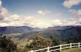
The Numinbah Valley is an area of the Gold Coast hinterland
in South East Queensland
, Australia
. This Scenic Rim
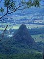
valley contains many rocky outcrops, waterfalls, rainforest walks, and good hinterland scenery.
Compared to other areas of the Gold Coast the Numinbah Valley has remained largely undeveloped in recent decades. To the east is the Springbrook
plateau. On the eastern side of the valley is the Natural Bridge in Springbrook National Park
and to the west lies the Lamington Plateau and the Lamington National Park
. To the south is the Tweed Valley.
Vegetation in the valley includes dry and wet sclerophyll forest. The valley is the upper catchment for the Nerang River
which flows into the Hinze Dam
in the lowest and most northern part of the valley.
The communities of Advancetown and the small township of Numinbah are located in Numinbah Valley. The valley was first explored by timber cutters seeking cedar
in 1845. Bullocks hauled the felled timer to Nerang
. Later in the 1860s, when a route to the Tweed Valley was discovered as surveyors mapped the Queensland/New South Wales border, settlers moved into the area. A township developed in the 1880s. A sawmill operated from 1909 until 1944 when agriculture and dairying became the primary industries.
and Numinbah Valley State Primary School. A Numinbah Valley Landcare group operates in the valley.
Camp Bornhoffin or the Numinbah Valley Environmental Education Centre caters for large groups of students. These large recreational facilities are situated in the southern and most hightest part where the headwaters of the Nerang River coalesce.
Gold Coast hinterland
The Gold Coast hinterland is an area of South East Queensland, Australia that comprises the Tweed Range, Nimmel Range, Tamborine Mountain, Numinbah Valley, eastern parts of the McPherson Range and western parts of suburban Gold Coast.-History:...
in South East Queensland
South East Queensland
South East Queensland is a region of the state of Queensland in Australia, which contains approximately two-thirds of the state population...
, Australia
Australia
Australia , officially the Commonwealth of Australia, is a country in the Southern Hemisphere comprising the mainland of the Australian continent, the island of Tasmania, and numerous smaller islands in the Indian and Pacific Oceans. It is the world's sixth-largest country by total area...
. This Scenic Rim
Scenic Rim
The Scenic Rim is a group of forested mountain ranges of the Great Dividing Range straddling the border between south-eastern Queensland and north-eastern New South Wales, Australia.-Description:...
valley contains many rocky outcrops, waterfalls, rainforest walks, and good hinterland scenery.
Compared to other areas of the Gold Coast the Numinbah Valley has remained largely undeveloped in recent decades. To the east is the Springbrook
Springbrook, Queensland
Springbrook is a suburb, mountain and plateau in the Gold Coast hinterland of South East Queensland. The highest point, known as Springbrook Mountain is high...
plateau. On the eastern side of the valley is the Natural Bridge in Springbrook National Park
Springbrook National Park
Springbrook National Park is a national park at Springbrook on the McPherson Range in the Gold Coast hinterland of Queensland, , 96 km south of Brisbane. It is part of the Shield Volcano Group of the World Heritage site Gondwana Rainforests of Australia...
and to the west lies the Lamington Plateau and the Lamington National Park
Lamington National Park
Lamington is a national park in Queensland, Australia, lying on the Lamington Plateau of the McPherson Range on the Queensland/New South Wales border...
. To the south is the Tweed Valley.
Vegetation in the valley includes dry and wet sclerophyll forest. The valley is the upper catchment for the Nerang River
Nerang River
The Nerang River is a river that begins in the McPherson Range in the Gold Coast hinterland and runs through Gold Coast City in South East Queensland, Australia...
which flows into the Hinze Dam
Hinze Dam
The Hinze Dam, also known as Advancetown Lake, supplies most of the water provided to Gold Coast City in Queensland, Australia. Some water is drawn from Little Nerang Dam and until recently northern suburbs received water from Wivenhoe Dam. It was completed in 1976 and expanded in 1989. Advancetown...
in the lowest and most northern part of the valley.
The communities of Advancetown and the small township of Numinbah are located in Numinbah Valley. The valley was first explored by timber cutters seeking cedar
Toona ciliata
Australian Red Cedar , Toona ciliata is a forest tree in the family Meliaceae which grows throughout southern Asia from Afghanistan to Papua New Guinea and Australia. In Australia its natural habitat is now extensively cleared subtropical rainforests of New South Wales and Queensland...
in 1845. Bullocks hauled the felled timer to Nerang
Nerang, Queensland
Nerang is a suburb on the Gold Coast in Queensland, Australia, that lies upon the Nerang River. At the 2006 Census, Nerang had a population of 16,066....
. Later in the 1860s, when a route to the Tweed Valley was discovered as surveyors mapped the Queensland/New South Wales border, settlers moved into the area. A township developed in the 1880s. A sawmill operated from 1909 until 1944 when agriculture and dairying became the primary industries.
Facilities
Institutions built in Numinbah Valley include the Numinbah Correctional CentreNuminbah Correctional Centre
Numinbah Correctional Centre is an open prison on a reserve 100 km south of Brisbane in the Numinbah Valley.The centre houses 104 male prisoners in separate rooms and in an annex 25 female prisoners, a mix of short and long-term.-References:...
and Numinbah Valley State Primary School. A Numinbah Valley Landcare group operates in the valley.
Camp Bornhoffin or the Numinbah Valley Environmental Education Centre caters for large groups of students. These large recreational facilities are situated in the southern and most hightest part where the headwaters of the Nerang River coalesce.
See also
- Fassifern ValleyFassifern ValleyFassifern Valley is a valley of the Scenic Rim in South East Queensland. Towns found in the valley include Harrisville, Kalbar, Roadvale, Warril View and Aratula...
- List of valleys of Australia
- Lockyer ValleyLockyer Valley, QueenslandThe Lockyer Valley is an area of rich farmlands that lies to the west of Brisbane, Queensland, Australia and east of Toowoomba. The Lockyer Valley is rated among the top ten most fertile farming areas in the world...
- Samford ValleySamford, QueenslandSamford is a valley community located in South East Queensland, Australia. It is roughly 21 km north west of Brisbane. The hilly area was first settled in the mid 1850s. The community is well catered for, with a number of sporting facilities, parks and museums.-Location:Samford is one of the...