
Fassifern Valley
Encyclopedia
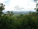
Fassifern Valley is a valley of the Scenic Rim
in South East Queensland
. Towns found in the valley include Harrisville, Kalbar
, Roadvale
, Warril View and Aratula
. Fassifern Valley is known as a carrot producing area, as well as for growing potatoes, onions, pumpkin
s and melons.
The Cunningham Highway
passes through the town of Aratula and along ridges in the upper valley towards Cunninghams Gap, Mount Mitchell
and parts of Main Range National Park
. The valley has become known as one of the driest catchments in the Queensland during recent droughts in Australia
. The Moogerah Peaks are a series of mountain peaks in the south east of the catchment.
To the east lies the valleys of the Logan River
. Further to the west is the dry catchment of Laidley Creek and Lockyer Creek
in the Lockyer Valley
while Amberley
is located just to the north of the valley.
was the first European to explore the valley in 1827, during which he climbed Mount French. The valley was first settled by pastoralists during the 1840s. The first settlers in the area where John Cameron and his brother-in-law Robert Coulson. The pair had arrived on the Darling Downs only to find all the best land already taken up. They eventually established themselves in the Fassifern Valley where number of other pastoral runs were established in the following decades, nearly all with familial connections to John Cameron. Many of the sheep and cattle stations names from the 19th century became the names of villages and towns in the valley, such as Moogerah, Bromelton
and Dugandan which was later to become known as Boonah.
In September 1887, the Dugandan railway line was opened connecting Dugandan to the main line in the north. Timber-cutting served at least five sawmills in the area.
was built on Reynolds Creek which runs into Warril Creek a tributary of the Bremer River which drains the slopes to the west of Fassifern Valley. Irrigation
allowed local farmers to diversify crops after dairy farming declined in the 1960s.
Scenic Rim
The Scenic Rim is a group of forested mountain ranges of the Great Dividing Range straddling the border between south-eastern Queensland and north-eastern New South Wales, Australia.-Description:...
in South East Queensland
South East Queensland
South East Queensland is a region of the state of Queensland in Australia, which contains approximately two-thirds of the state population...
. Towns found in the valley include Harrisville, Kalbar
Kalbar, Queensland
Kalbar is a small town in the Scenic Rim, South East Queensland, Australia. It is located near the Cunningham Highway and directly north of Mount French in the Fassifern Valley. The town is part of the Scenic Rim Region local government area. At the 2006 census, Kalbar had a population of...
, Roadvale
Roadvale, Queensland
Roadvale is a small village located in the Fassifern Valley, South east Queensland, Australia, north of the principal town Boonah and south west of the capital Brisbane. At the 2006 census, Roadvale and the surrounding area had a population of 559....
, Warril View and Aratula
Aratula, Queensland
Aratula is a small town in South East Queensland, approximately 60 kilometres southwest of Ipswich, just east of Cunninghams Gap. Warril Creek passes very close to the town...
. Fassifern Valley is known as a carrot producing area, as well as for growing potatoes, onions, pumpkin
Pumpkin
A pumpkin is a gourd-like squash of the genus Cucurbita and the family Cucurbitaceae . It commonly refers to cultivars of any one of the species Cucurbita pepo, Cucurbita mixta, Cucurbita maxima, and Cucurbita moschata, and is native to North America...
s and melons.
The Cunningham Highway
Cunningham Highway
The Cunningham Highway is a National Highway in Queensland, Australia. It is named after the explorer and botanist Allan Cunningham who followed a route close to where the modern day highway runs.-Route:...
passes through the town of Aratula and along ridges in the upper valley towards Cunninghams Gap, Mount Mitchell
Mount Mitchell (Queensland)
Mount Mitchell lies about 100 km west of Brisbane, Australia and immediately south of Cunninghams Gap. The peak to the south of the gap was named by Allan Cunningham in 1828 and today is part of the Main Range National Park. Cunningham named the mountain after the Surveyor-General, Thomas...
and parts of Main Range National Park
Main Range National Park
Main Range is a mountain range and a national park in Queensland , 85 km southwest of Brisbane. It is part of the World Heritage Site Gondwana Rainforests of Australia . It protects the western part of a semicircle of mountains in South East Queensland known as the Scenic Rim...
. The valley has become known as one of the driest catchments in the Queensland during recent droughts in Australia
Drought in Australia
Drought in Australia is defined as rainfall over a three month period being in the lowest decile of what has been recorded for that region in the past. This definition takes into account that drought is a relative term and rainfall deficiencies need to be compared to typical rainfall patterns...
. The Moogerah Peaks are a series of mountain peaks in the south east of the catchment.
To the east lies the valleys of the Logan River
Logan River
The Logan River is a river in South East Queensland. The catchment is dominated by urban and agricultural land use. Near the river mouth are mangrove forests and a number of aquaculture farms.-History:...
. Further to the west is the dry catchment of Laidley Creek and Lockyer Creek
Lockyer Creek, Queensland
Lockyer Creek is a major drainage system in the Lockyer Valley of South East Queensland that flows into the Brisbane River a few kilometres north-north/east of Lowood, and downstream from the Wivenhoe Dam...
in the Lockyer Valley
Lockyer Valley, Queensland
The Lockyer Valley is an area of rich farmlands that lies to the west of Brisbane, Queensland, Australia and east of Toowoomba. The Lockyer Valley is rated among the top ten most fertile farming areas in the world...
while Amberley
Amberley, Queensland
Amberley is a small community located in South East Queensland, south of Ipswich.The origin of the suburb name is from Amberley in the United Kingdom...
is located just to the north of the valley.
History
Captain Patrick LoganPatrick Logan
Captain Patrick Logan was the commandant of the Moreton Bay penal colony from 1826 until his death in 1830. He is thought to have been killed by Aboriginal Australians who objected to him entering their lands...
was the first European to explore the valley in 1827, during which he climbed Mount French. The valley was first settled by pastoralists during the 1840s. The first settlers in the area where John Cameron and his brother-in-law Robert Coulson. The pair had arrived on the Darling Downs only to find all the best land already taken up. They eventually established themselves in the Fassifern Valley where number of other pastoral runs were established in the following decades, nearly all with familial connections to John Cameron. Many of the sheep and cattle stations names from the 19th century became the names of villages and towns in the valley, such as Moogerah, Bromelton
Bromelton, Queensland
Bromelton is a small village in southern Queensland, Australia. At the 2006 census, Bromelton and the surrounding area had a population of 536.- Transport :The town has a crossing loop on the national standard gauge railway network...
and Dugandan which was later to become known as Boonah.
In September 1887, the Dugandan railway line was opened connecting Dugandan to the main line in the north. Timber-cutting served at least five sawmills in the area.
Moogerah Dam
Lake MoogerahLake Moogerah
Lake Moogerah, formed by Moogerah Dam, is a water supply and irrigation dam on Reynolds Creek, a tributary of the Bremer River in Southeast Queensland's Fassifern Valley. The lake is used for recreation, fishing and camping...
was built on Reynolds Creek which runs into Warril Creek a tributary of the Bremer River which drains the slopes to the west of Fassifern Valley. Irrigation
Irrigation
Irrigation may be defined as the science of artificial application of water to the land or soil. It is used to assist in the growing of agricultural crops, maintenance of landscapes, and revegetation of disturbed soils in dry areas and during periods of inadequate rainfall...
allowed local farmers to diversify crops after dairy farming declined in the 1960s.
See also
- List of valleys of Australia
- Numinbah ValleyNuminbah ValleyThe Numinbah Valley is an area of the Gold Coast hinterland in South East Queensland, Australia. This Scenic Rim valley contains many rocky outcrops, waterfalls, rainforest walks, and good hinterland scenery....
- Samford Valley