
Gold Coast hinterland
Encyclopedia
The Gold Coast hinterland is an area of South East Queensland
, Australia
that comprises the Tweed Range
, Nimmel Range, Tamborine Mountain, Numinbah Valley
, eastern parts of the McPherson Range
and western parts of suburban Gold Coast
.
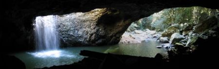
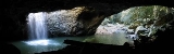
and people living in the region. Visitor surveys to the hinterland's parks and forests indicate the area is one of Queensland's most significant tourist destinations. Wine-tasting, bird-feeding, eco-tourism and bushwalking are some of the pastimes that attract visitors to the hinterland. Other attractions in the area include O'Reilly's Guesthouse
, the Natural Bridge and Binna Burra
. In March 2008, the Gold Coast Hinterland Great Walk connecting the Lamington and Springbrook plateaus was opened. The moderately difficult walking trail provides 54 km of uninterrupted track and takes three days to walk from start to finish.
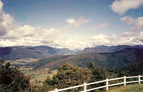 This elevated area is part of the Great Dividing Range
and contains the headwaters for a number of rivers and creeks including the Coomera River
, Nerang River
, Pimpama River
, Tallebudgera Creek
and Currumbin Creek
. Some of the highest mountains in the hinterland are Mount Nimmel
(489 m), Mount Tamborine (525 m), Mount Cougal at (739 m), Tallebudgera Mountain (664m) and Springbrook Mountain (900 m). In New South Wales to the south are the Tweed Valley and Border Ranges
, while the Scenic Rim
overlaps and extends westwards from the hinterland.
suburbs of Mudgeeraba
, Tallebudgera
and Nerang
. There are a number of small villages like Advancetown, Beechmont
and Canungra
that are considered part of the hinterland.
At the foot of Mount Nimmel
lies Austinville
and beyond, the towering plateau of Springbrook Mountain, on top of which lies a small township by the same name. Some have commented some of these sleepy suburbs are reminiscent of a 19th century village, as these areas are some of the oldest in the relatively young Gold Coast.
 The region has significant natural heritage that is preserved in national parks and has been a major tourist drawcard. Much of the national parks are UNESCO World Heritage listed as well as listed nationally
as part of the Gondwana Rainforests of Australia. Springbrook National Park
covers 2720 hectares of rainforest
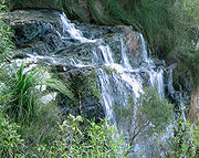
, plenty of which is accessible by walking trails. Remnants of early forestry
history await you as well as several waterfalls, including the famous Purlingbrook Falls
, as well as many gorges and much rainforest.
Lamington National Park
covers 20,590 hectares of rainforest
, consisting mainly of two sections, the Green Mountains and Binna Burra
. The longest available walk is 24 kilometres, about 8 hours walking time. Tamborine National Park
covers 1160 hectares of the Tamborine Mountain, a remnant of the once giant Tweed Volcano
.
Closer to the coast, although not technically part of the hinterland, is the Currumbin Valley Reserve
.
South East Queensland
South East Queensland is a region of the state of Queensland in Australia, which contains approximately two-thirds of the state population...
, Australia
Australia
Australia , officially the Commonwealth of Australia, is a country in the Southern Hemisphere comprising the mainland of the Australian continent, the island of Tasmania, and numerous smaller islands in the Indian and Pacific Oceans. It is the world's sixth-largest country by total area...
that comprises the Tweed Range
Tweed Range
The Tweed Range is the western extension of the Tweed Volcano caldera rim in northern New South Wales, Australia. The range marks the southern extinct of the Scenic Rim. The Bar Mountain massif is the highest point on the range, rising to 1130 m above sea level...
, Nimmel Range, Tamborine Mountain, Numinbah Valley
Numinbah Valley
The Numinbah Valley is an area of the Gold Coast hinterland in South East Queensland, Australia. This Scenic Rim valley contains many rocky outcrops, waterfalls, rainforest walks, and good hinterland scenery....
, eastern parts of the McPherson Range
McPherson Range
The McPherson Range is an extensive mountain range, a spur of the Great Dividing Range, heading in an easterly direction from near Wallangarra to the Pacific Ocean coastline. It forms part of the Scenic Rim on the border between the states of New South Wales and Queensland. Further west of the...
and western parts of suburban Gold Coast
Gold Coast, Queensland
Gold Coast is a coastal city of Australia located in South East Queensland, 94km south of the state capital Brisbane. With a population approximately 540,000 in 2010, it is the second most populous city in the state, the sixth most populous city in the country, and also the most populous...
.
History
The comprehensive exploration of the area was conducted only as late as 1842. Surveyors attempted to map the Queensland/New South Wales border during the 1860s were hampered by the rough terrain and plateaus. Shortly after timber-getters passed Numinbah Gap from the Tweed Valley, establishing a route from the Tweed region to Brisbane that was later used by coach and bullock teams. In 1908, Witches Falls was protected by Queensland's first national park declaration.Tourism
In the Gold Coast hinterland there are various scenic attractions and guesthouses that have led to the development of a vibrant tourism industry, providing a major attraction for visitors to the Gold CoastGold Coast, Queensland
Gold Coast is a coastal city of Australia located in South East Queensland, 94km south of the state capital Brisbane. With a population approximately 540,000 in 2010, it is the second most populous city in the state, the sixth most populous city in the country, and also the most populous...
and people living in the region. Visitor surveys to the hinterland's parks and forests indicate the area is one of Queensland's most significant tourist destinations. Wine-tasting, bird-feeding, eco-tourism and bushwalking are some of the pastimes that attract visitors to the hinterland. Other attractions in the area include O'Reilly's Guesthouse
O'Reilly's Guesthouse
O'Reilly's Rainforest Retreat is a tourist destination in Queensland, Australia, situated in the heart of the Lamington National Park, two hours by road south of Brisbane and 90 minutes by road west of the Gold Coast. It is located in the Scenic Rim Region Local Government Area and and is...
, the Natural Bridge and Binna Burra
Binna Burra
Binna Burra is a parcel of private land surrounded by Lamington National Park in Queensland, Australia. The settlement lies in the north-eastern corner of the Lamington Plateau, 75 km south of Brisbane. It is a part of the World Heritage site, Gondwana Rainforests of Australia...
. In March 2008, the Gold Coast Hinterland Great Walk connecting the Lamington and Springbrook plateaus was opened. The moderately difficult walking trail provides 54 km of uninterrupted track and takes three days to walk from start to finish.
Geography
Great Dividing Range
The Great Dividing Range, or the Eastern Highlands, is Australia's most substantial mountain range and the third longest in the world. The range stretches more than 3,500 km from Dauan Island off the northeastern tip of Queensland, running the entire length of the eastern coastline through...
and contains the headwaters for a number of rivers and creeks including the Coomera River
Coomera River
The Coomera River is a river situated in South East Queensland. The upper reaches of the river flow from the Lamington plateau and the Lamington National Park. Here are the spectacular Coomera Falls in the Coomera Gorge...
, Nerang River
Nerang River
The Nerang River is a river that begins in the McPherson Range in the Gold Coast hinterland and runs through Gold Coast City in South East Queensland, Australia...
, Pimpama River
Pimpama River
The Pimpama River is a river situated in South East Queensland, with its catchment located in the northern part of Gold Coast City. It is bounded by the Logan/Albert River catchment to the north, the Coomera River catchment to the south and the Broadwater in the east...
, Tallebudgera Creek
Tallebudgera Creek
Tallebudgera Creek is a large creek on the Gold Coast which runs from the Springbrook Plateau in the west through Tallebudgera Valley to the southern slopes of Burleigh Mountain at Burleigh Heads and the Pacific Ocean in the east...
and Currumbin Creek
Currumbin Creek
Currumbin Creek is a large creek on the Gold Coast of Queensland, running from Mount Cougal in the west to its mouth at Currumbin Alley in the east. It is apporoximately in length. It provides a popular and tranquil setting for many rowing clubs, kayakers, jet skiers, boat-goers and fishermen.The...
. Some of the highest mountains in the hinterland are Mount Nimmel
Mount Nimmel
Mount Nimmel is a small mountain located in Austinville, Queensland in Australia. Nimmel is an Australian indigenous word meaning 'Conspicuous Mountain', which is ironic, considering it is very small when compared to the nearby Springbrook Mountain, Tamborine Mountain and Mount Cougal's twin...
(489 m), Mount Tamborine (525 m), Mount Cougal at (739 m), Tallebudgera Mountain (664m) and Springbrook Mountain (900 m). In New South Wales to the south are the Tweed Valley and Border Ranges
Border Ranges National Park
Border Ranges National Park, 150 km south of Brisbane, Australia, is in northern New South Wales with a small portion located in Queensland....
, while the Scenic Rim
Scenic Rim
The Scenic Rim is a group of forested mountain ranges of the Great Dividing Range straddling the border between south-eastern Queensland and north-eastern New South Wales, Australia.-Description:...
overlaps and extends westwards from the hinterland.
Suburbs and townships
Land use in the hinterland is divided between protected areas and rural residential living. On the eastern foothills of the hinterland lie the Gold CoastGold Coast, Queensland
Gold Coast is a coastal city of Australia located in South East Queensland, 94km south of the state capital Brisbane. With a population approximately 540,000 in 2010, it is the second most populous city in the state, the sixth most populous city in the country, and also the most populous...
suburbs of Mudgeeraba
Mudgeeraba, Queensland
Mudgeeraba is a suburb of the Gold Coast. Mudgeeraba is remnant of the type of township that characterises the rural hinterland of the Gold Coast. Subdivision of land was conventional and buildings were traditionally rural or rural commercial. Mudgeeraba, like other areas, was an early centre,...
, Tallebudgera
Tallebudgera, Queensland
Tallebudgera , originally known as Maybree, is a suburb of the Australian city of Gold Coast. The suburb is located in the Gold Coast hinterland and is a small community of overwhelmingly single family dwellings...
and Nerang
Nerang, Queensland
Nerang is a suburb on the Gold Coast in Queensland, Australia, that lies upon the Nerang River. At the 2006 Census, Nerang had a population of 16,066....
. There are a number of small villages like Advancetown, Beechmont
Beechmont, Queensland
Beechmont is a residential village located in the Gold Coast hinterland of eastern Australia.The suburb is positioned on a forested ridge leading from the Lamington Plateau to Tambourine Mountain...
and Canungra
Canungra, Queensland
Canungra is a small picturesque rural township in South East Queensland, Australia. Its economy depends on tourism, being a popular destination for short drives from the Gold Coast and Brisbane. Canungra, also called the "Valley of the Owls", is situated in the Gold Coast Hinterland, west of the...
that are considered part of the hinterland.
At the foot of Mount Nimmel
Mount Nimmel
Mount Nimmel is a small mountain located in Austinville, Queensland in Australia. Nimmel is an Australian indigenous word meaning 'Conspicuous Mountain', which is ironic, considering it is very small when compared to the nearby Springbrook Mountain, Tamborine Mountain and Mount Cougal's twin...
lies Austinville
Austinville, Queensland
Austinville is a small, historic suburb of Queensland covering approximately 20 kilometres squared and situated in the Gold Coast Hinterland between Mudgeeraba and Springbrook consisting of a population of 419...
and beyond, the towering plateau of Springbrook Mountain, on top of which lies a small township by the same name. Some have commented some of these sleepy suburbs are reminiscent of a 19th century village, as these areas are some of the oldest in the relatively young Gold Coast.
Protected areas
Australian National Heritage List
The Australian National Heritage List is a list of places deemed to be of outstanding heritage significance to Australia. The list includes natural, historic and indigenous places...
as part of the Gondwana Rainforests of Australia. Springbrook National Park
Springbrook National Park
Springbrook National Park is a national park at Springbrook on the McPherson Range in the Gold Coast hinterland of Queensland, , 96 km south of Brisbane. It is part of the Shield Volcano Group of the World Heritage site Gondwana Rainforests of Australia...
covers 2720 hectares of rainforest
Rainforest
Rainforests are forests characterized by high rainfall, with definitions based on a minimum normal annual rainfall of 1750-2000 mm...
, plenty of which is accessible by walking trails. Remnants of early forestry
Forestry
Forestry is the interdisciplinary profession embracing the science, art, and craft of creating, managing, using, and conserving forests and associated resources in a sustainable manner to meet desired goals, needs, and values for human benefit. Forestry is practiced in plantations and natural stands...
history await you as well as several waterfalls, including the famous Purlingbrook Falls
Purlingbrook Falls
Purlingbrook Falls are found within the central section of Springbrook National Park, at Springbrook which is part of the Gold Coast hinterland, south-west of Surfers Paradise, in Queensland, Australia....
, as well as many gorges and much rainforest.
Lamington National Park
Lamington National Park
Lamington is a national park in Queensland, Australia, lying on the Lamington Plateau of the McPherson Range on the Queensland/New South Wales border...
covers 20,590 hectares of rainforest
Rainforest
Rainforests are forests characterized by high rainfall, with definitions based on a minimum normal annual rainfall of 1750-2000 mm...
, consisting mainly of two sections, the Green Mountains and Binna Burra
Binna Burra
Binna Burra is a parcel of private land surrounded by Lamington National Park in Queensland, Australia. The settlement lies in the north-eastern corner of the Lamington Plateau, 75 km south of Brisbane. It is a part of the World Heritage site, Gondwana Rainforests of Australia...
. The longest available walk is 24 kilometres, about 8 hours walking time. Tamborine National Park
Tamborine National Park
Tamborine is a national park in the Gold Coast hinterland of South East Queensland, Australia, 45 km south of Brisbane.It covers 11.60 km² on the plateau of Tamborine Mountain and around its foothills. The plateau is 8 km long, 5 km wide and rises to an altitude of 525 meters...
covers 1160 hectares of the Tamborine Mountain, a remnant of the once giant Tweed Volcano
Tweed Volcano
Tweed Volcano was an early Miocene shield volcano in northeastern New South Wales, Australia. In the course of about three million years, Tweed Volcano was formed over the East Australia hotspot when this part of the continent passed over it around 23 million years ago...
.
Closer to the coast, although not technically part of the hinterland, is the Currumbin Valley Reserve
Currumbin Valley Reserve
Currumbin Valley Reserve is a 4 ha nature reserve in the Gold Coast hinterland of south-east Queensland, Australia, west of Coolangatta, 105 km south of Brisbane...
.
See also
- Regions of QueenslandRegions of QueenslandThe Regions of Queensland refers to the geographic areas of the Australian state of Queensland. Due to its large size and decentralised population, the state is often divided into regions for statistical and administrative purposes. Each region varies somewhat in terms of its economy, population,...
- Road routes in Gold Coast
- Tourism in AustraliaTourism in AustraliaTourism is an important industry for the Australian economy. In the financial year 2009/10, the tourism industry represented 2.6% of Australia's GDP at a value of approximately A$34 billion to the national economy. Domestic tourism is a significant part of the tourism industry, and was...