
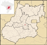
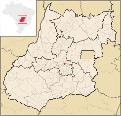
Nova Veneza, Goiás
Encyclopedia
| Nova Veneza, Goiás | |
|---|---|
| State | Goiás Goiás Goiás is a state of Brazil, located in the central part of the country. The name Goiás comes from the name of an indigenous community... |
| Coordinates: | 16°16′23"S 49°19′26"W |
| Area: | 123.3 km² |
| Population: | 6,884 (IBGE 2007) |
| Elevation: | 806 m above sea level |
| Postcode (CEP): | 75470-000 |
| Became a city: | 1993 |
| Distance to Goiânia Goiânia -Climate:The city has a tropical wet and dry climate with an average temperature of . There's a wet season, from October to April, and a dry one, from May to September. Annual rainfall is around 1,520 mm.... : |
33 km |
| IBGE statistical microregion: | Anápolis Microregion Anápolis Microregion The Anápolis Microregion is a region of central Goiás state, Brazil, including municipalities surrounding the city of Anápolis. For a map see *Population: 517,221 inhabitants *Cities: 19*Total Area: 8,386.80 km²... |
| Website: | n/a |
Town
A town is a human settlement larger than a village but smaller than a city. The size a settlement must be in order to be called a "town" varies considerably in different parts of the world, so that, for example, many American "small towns" seem to British people to be no more than villages, while...
and municipality
Municipality
A municipality is essentially an urban administrative division having corporate status and usually powers of self-government. It can also be used to mean the governing body of a municipality. A municipality is a general-purpose administrative subdivision, as opposed to a special-purpose district...
in central Goiás
Goiás
Goiás is a state of Brazil, located in the central part of the country. The name Goiás comes from the name of an indigenous community...
state, Brazil
Brazil
Brazil , officially the Federative Republic of Brazil , is the largest country in South America. It is the world's fifth largest country, both by geographical area and by population with over 192 million people...
.
Location
Nova Veneza is located between GoiâniaGoiânia
-Climate:The city has a tropical wet and dry climate with an average temperature of . There's a wet season, from October to April, and a dry one, from May to September. Annual rainfall is around 1,520 mm....
and Anápolis
Anápolis
Anápolis is the third largest city in the State of Goiás in Brazil. It lies in the center of a rich agricultural region and has become a leader in food processing and pharmaceutical plants.-Location and population:...
.
- Distance to GoiâniaGoiânia-Climate:The city has a tropical wet and dry climate with an average temperature of . There's a wet season, from October to April, and a dry one, from May to September. Annual rainfall is around 1,520 mm....
: 33 km. - Distance to AnápolisAnápolisAnápolis is the third largest city in the State of Goiás in Brazil. It lies in the center of a rich agricultural region and has become a leader in food processing and pharmaceutical plants.-Location and population:...
: 49 km. - Highway connections: GO-462 / Santo Antônio de GoiásSanto Antônio de GoiásSanto Antônio de Goiás is a small town and municipality in central Goiás state, Brazil, located just north of the state capital, Goiânia.*Distance from Goiânia: 42 km...
.
Neighboring municipalities: Damolândia
Damolândia
Damolândia is a small town and municipality in central Goiás state, Brazil.-Highway connections:The distance to Goiânia is 79 km. while the distance to Anápolis is 62 km. Highway connections from Goiânia: GO-462 / Santo Antônio de Goiás / GO-222 / Nova Veneza / GO-416...
, Ouro Verde de Goiás
Ouro Verde de Goiás
Ouro Verde de Goiás is a small town and municipality in central Goiás state, Brazil.-Location:Ouro Verde is 63 km. northeast of Goiânia and 31 km west of Anápolis....
, Brazabrantes
Brazabrantes
Brazabrantes is a small town and municipality in central Goiás state, Brazil.-Location:Brazabrantes is located 59 kilometers north of the important city of . Highway connections from the state capital of Goiânia are made by taking state highway GO-70 north to Goanira and then east to...
, and Goiânia
Goiânia
-Climate:The city has a tropical wet and dry climate with an average temperature of . There's a wet season, from October to April, and a dry one, from May to September. Annual rainfall is around 1,520 mm....
Demographic Information
In 2007 the population density was 55.80 inhab/km². In 2007 there were 5,875 inhabitants in the urban area and 1,009 in the rural area. The population has increased by about 2,100 since 1980.Economic Information
The main economic activities were agriculture, livestock raising, services, and government employment. The main crops were rice, sugarcane, corn, tomatoes, and citrus fruits. There was a fairly substantial poultry industry with more than 600,000 birds in 2006.- Number of industrial establishments: 21
- Number of retail establishments: 57
- Banking establishments: Banco Itaú S.A.
- Automobiles: 597
Agricultural data 2006
- Number of Farms: 244
- Total area: 7,362 ha.
- Area of permanent crops: 167 ha. (citrus fruits)
- Area of perennial crops: 796 ha. (corn, sugarcane, beans, and rice)
- Area of natural pasture: 7,635 ha.
- Area of woodland and forests: 1,039 ha.
- Persons dependent on farming: 480
- Farms with tractors: 21
- Number of tractors: 28
- Cattle herd: 16,900 head IBGE
Health and Education
In 2007 there was 1 hospital with 18 beds and 4 walk-in health clinics. In 2000 the infant mortality rate was 25.56, well below the national average of 33.0.In 2006 the school system had 6 schools, 47 classrooms, 81 teachers, and 1,942 students. There was 1 middle/secondary school with 375 students. In 2000 the literacy rate was 86.5%, slightly above the national average of 86.4%.
Income Distribution
Out of 1,811 households in 2000, 919 declared less than 1 minimum salary of income.
Nova Veneza scored 0.731 on the Municipal Human Development Index
Human Development Index
The Human Development Index is a composite statistic used to rank countries by level of "human development" and separate "very high human development", "high human development", "medium human development", and "low human development" countries...
, placing it 141 (out of 242 municipalities)in the state. All data are from 2000. For the complete list see frigoletto.com.br