

Northern Cheyenne Exodus
Encyclopedia
Indian reservation
An American Indian reservation is an area of land managed by a Native American tribe under the United States Department of the Interior's Bureau of Indian Affairs...
in the Indian Territory
Indian Territory
The Indian Territory, also known as the Indian Territories and the Indian Country, was land set aside within the United States for the settlement of American Indians...
, and the United States Army
United States Army
The United States Army is the main branch of the United States Armed Forces responsible for land-based military operations. It is the largest and oldest established branch of the U.S. military, and is one of seven U.S. uniformed services...
operations to stop them. The period lasted from 1877 to 1879.
Following the Battle of the Little Bighorn
Battle of the Little Bighorn
The Battle of the Little Bighorn, also known as Custer's Last Stand and, by the Indians involved, as the Battle of the Greasy Grass, was an armed engagement between combined forces of Lakota, Northern Cheyenne and Arapaho people against the 7th Cavalry Regiment of the United States Army...
attempts by the U.S. Army to subdue the Northern Cheyenne intensified. In 1877, after the Dull Knife Fight
Dull Knife Fight
The Dull Knife Fight, or the Battle of Bates Creek, was a Great Plains battle in the Wyoming Territory between the United States Army and the Northern Cheyenne as part of the Great Sioux War of 1876-77. The battle essentially ended the Cheyennes' ability to wage war.After the battles of the Rosebud...
, when Crazy Horse
Crazy Horse
Crazy Horse was a Native American war leader of the Oglala Lakota. He took up arms against the U.S...
surrendered at Fort Robinson
Fort Robinson
Fort Robinson is a former U.S. Army fort and a present-day state park. Located in the Pine Ridge region of northwest Nebraska, it is west of Crawford on U.S. Route 20.- History :...
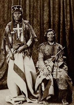
a few Cheyenne chiefs and their people surrendered as well. The Cheyenne chiefs that surrendered at the fort were Dull Knife, Little Wolf
Little Wolf
Little Wolf was a Northern Cheyenne Chief...
, Standing Elk, and Wild Hog with nearly one thousand Cheyenne. On the other hand Two Moon surrendered at Fort Keogh
Fort Keogh
Fort Keogh is located on the western edge of Miles City, Montana. Occasionally spelled Fort Keough. Originally a military post, today it is a United States Department of Agriculture livestock and range research station. It is listed on the National Register of Historic Places...
with three hundred Cheyenne in 1877. The Cheyenne wanted and expected to live on the reservation with the Sioux
Sioux
The Sioux are Native American and First Nations people in North America. The term can refer to any ethnic group within the Great Sioux Nation or any of the nation's many language dialects...
in accordance to an April 29, 1868 treaty of Fort Laramie of which both Dull Knife and Little Wolf had signed. However shortly after arriving at Fort Robinson it was recommended that the Northern Cheyenne be moved to the reservation at Fort Reno
Fort Reno
Fort Reno may refer to any of the three United States Army posts named for General Jesse L. Reno:*Fort Reno Park, in Washington, D.C., established 1862...
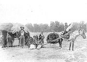
with the Southern Cheyenne. Following confirmation from Washington the Cheyenne started their move with 972 people; upon reaching the Cheyenne-Arapaho reservation on August 5, 1877 there were only 937. Some elderly had perished along the way and some young men crept away and headed back north. When reaching the reservation the Northern Cheyenne noticed how poverty-stricken the reservation was and began to fall sick in late summer of 1877. However when conditions did not improve upon a federal investigation into reservation conditions the Cheyenne were given authorization to hunt. When the Cheyenne attempted to find game to hunt none was found, just a wasteland of dead buffalo remains; this was the winter of 1877-1878. Unfortunately in 1878 there was a measles outbreak that struck the Northern Cheyenne, and in August 1878 the Cheyenne chiefs began the organization to move north.
On September 9, 1878 Little Wolf, Dull Knife, Wild Hog, and Left Hand told their people to organize to leave, leaving were 297 (the number could be as high as 353) men, women , and children. In the early morning of September 10 the band fled up the North Canadian River. By 3 AM the alarm was sounded that the Cheyenne were gone. Passing the present sites of Watonga, Oklahoma
Watonga, Oklahoma
Watonga is a city in Blaine County, Oklahoma, United States. The population was 4,658 at the 2000 census. It is the county seat of Blaine County.-Early History:...
and Canton, Oklahoma
Canton, Oklahoma
Canton is a town in Blaine County, Oklahoma, United States. The population was 625 at the 2010 census.-Geography:Canton is located at .According to the United States Census Bureau, the town has a total area of , all of it land....
they crossed north over the watershed into the Cimarron basin, crossing the Cimarron River the evening of September 10. There, near the present site of Freedom, Oklahoma
Freedom, Oklahoma
Freedom is a town in Woods County, Oklahoma, United States. The population was 289 at the 2010 census.-Geography:Freedom is located at .According to the United States Census Bureau, the town has a total area of , all of it land.-Climate:...
they rested then trailed 11 miles up Turkey Creek to Turkey Springs. After a few hours rest there Dull Knife and a few others led the women and children on to St. Jacob's Well and The Big Basin
Big Basin Prairie Preserve
The Big Basin Prairie Preserve is a nature preserve owned and managed by the Kansas Department of Wildlife and Parks. The preserve is in the Red Hills near Ashland in Clark County, Kansas. The main features are St. Jacob's Well, a water-filled sinkhole which lies in the Little Basin, and the Big...
in what is now Clark County, Kansas
Clark County, Kansas
Clark County is a county located in Southwest Kansas, in the Central United States. As of the 2010 census, the county population was 2,215...
where they camped.
The fight at Turkey Creek
The Cheyenne, anticipating pursuit, prepared an ambush at Turkey Springs. While one band prepared rifle pits at the springs, other bands fanned out over the country looking for supplies. In one case, attacking and killing two cowboys, they obtained two mules, in another, attacking some cowboys during breakfast, obtained both breakfast and a Sharps carbine.Battle of Punished Woman Creek
After crossing the Arkansas River the Cheyenne were followed closely by 250 troopers under the command of Colonel William Lewis. The Cheyenne had prepared an ambush in a canyon on Punished Woman Creek, but it was aborted by an over-eager brave who fired on the troops at a distance of 350 yards. Nevertheless, Colonel Lewis and a few other men were killed and the Cheyenne were able to continue their journey when the troops disengaged as darkness fell. However, the Cheyenne lost many horses and much baggage when part of the pony herd was discovered by the troopers.Depredations in Kansas
A party of drovers encountered Cheyenne camped on Prairie Dog Creek, in northwestern Kansas on September 29 and lost 80 cattle. Between September 30 and October 3, 1878, in northwestern Kansas in present day Decatur County, KansasDecatur County, Kansas
Decatur County is a county located in Northwest Kansas, in the Central United States. As of the 2010 census, the county population was 2,961. Its county seat and most populous city is Oberlin. The county is named in honor of Commodore Stephen Decatur, Jr.-History:The county was established...
and Rawlins County, Kansas
Rawlins County, Kansas
Rawlins County is a county located in the U.S. state of Kansas. As of the 2010 census, the county population was 2,519. The largest city and county seat is Atwood...
near Oberlin, Kansas
Oberlin, Kansas
Oberlin is a city in and the county seat of Decatur County, Kansas, United States. As of the 2010 census, the city population was 1,788.-History:...
, then a tiny hamlet, small parties of Cheyenne foraging for horses, cattle, and supplies fell on isolated settlers who had recently homesteaded along Sappa and Beaver Creeks, some of whom, recent immigrants from eastern Europe, had never seen an Indian; men and boys were killed; women and older girls raped. Often the settlers were approached in a friendly manner; then shot point blank. About 40 men and boys were killed and perhaps 25 women and girls raped. Some observers link the actions of the Cheyenne with the Battle of Cheyenne Hole, an action in the spring of 1875 in the same area when a small village of Cheyenne was surprised and destroyed by army troops.
On to Nebraska
From Turkey Creek on it was a running battle across the Kansas and Nebraska, and soldiers from all surrounding forts (Fort WallaceFort Wallace
Fort Wallace was a US Cavalry fort built in Wallace County, Kansas to help defend settlers against Cheyenne and Sioux raids. All that remains today is the cemetery, but for a period of over a decade Fort Wallace was one of the most important military outposts on the frontier.-External links:* * *...
, Fort Hays
Fort Hays
Fort Hays was an important frontier outpost of the United States Army located in Hays, Kansas between 1865 and 1889. Fort Hays was the home of several well-known Indian wars regiments including the Seventh U.S. Cavalry, the Fifth U.S. Infantry, and the Tenth U.S. Cavalry, whose black troopers were...
, Fort Dodge, Fort Riley
Fort Riley
Fort Riley is a United States Army installation located in Northeast Kansas, on the Kansas River, between Junction City and Manhattan. The Fort Riley Military Reservation covers 100,656 acres in Geary and Riley counties and includes two census-designated places: Fort Riley North and Fort...
, and Fort Kearney) were in pursuit of the Cheyenne. About ten thousand soldiers and three thousand settlers chased the Cheyenne both day and night. During the last two weeks of September the army had caught up to the Cheyenne five times but the Cheyenne was able to evade the army by keeping to arduous grounds where it was challenging for the army to follow.
Division
In the fall of 1878 after six weeks of running the Cheyenne chiefs held council and it was discovered that 34 of the original 297 were missing, most had been killed but a few had decided to take other paths to the north. This is where the Cheyenne split into two groups. The ones that wished to stop running were going along with Dull Knife to Red Cloud AgencyRed Cloud Agency
The Red Cloud Agency was an Indian agency for the Oglala Lakota as well as the Northern Cheyenne and Arapaho, from 1871 to 1878. It was located at three different sites in Wyoming Territory , before being moved to South Dakota. It was then renamed the Pine Ridge Reservation.- Red Cloud Agency No...
, Wild Hog and Left Hand also decided to follow Dull Knife. Little Wolf continued north intending to go to the Power River country.
Dull Knife's band
On October 23, 1878 Dull Knife's band of Cheyenne, only two days from Fort Robinson happen to be surrounded by the army. After hearing that Red CloudRed Cloud
Red Cloud , was a war leader and the head Chief of the Oglala Lakota . His reign was from 1868 to 1909...
and Spotted Tail
Spotted Tail
Siŋté Glešká was a Brulé Lakota tribal chief. Although a great warrior in his youth, and having taken part in the Grattan massacre, he declined to participate in Red Cloud's War, having become convinced of the pointlessness of opposing the white incursions into his homeland; he became a...
had been relocated to Pine Ridge, decided due to weather and his peoples condition to go to Fort Robinson anyhow. The Cheyenne decided that night to take apart their best guns, women hid the barrels under their clothing and the smaller pieces were attached to cloths and moccasins as ornaments. On October 25, 1878 Dull Knife, Left Hand, Wild Hog and rest of the Cheyenne finally reached Fort Robinson. The barracks that were built to hold seventy-five soldiers now held one hundred and fifty Cheyenne. In December Red Cloud was brought to Fort Robinson for a council with Dull Knife and the other chiefs. Dull Knife agreed to fight no more if the great father in Washington would let his people live on Pine Ridge
Pine Ridge
Pine Ridge may refer to:*Pine Ridge , of northwestern Nebraska and southwestern South Dakota*Pine Ridge Indian Reservation of southwestern South Dakota*Pine Ridge Campaign of the United States Army*Pine Ridge, Alabama...
that now held Red Cloud and his tribe. However on January 3, 1879 the Cheyenne were ordered to return south to the Southern Cheyenne reservation. When the Cheyenne refuse to return to the reservation in the south, bars were put on windows and no rations were given, including wood for heat. On January 9, 1879 Dull Knife still refused to go back south, however Wild Hog and Left Hand had agreed to talk but said their people would not go. Upon hearing this Wild Hog was held as a prisoner and shackled. At 9:45 that night the Cheyenne tried to make a daring escape using the dismantled guns they had hidden upon arriving at the fort. The Cheyenne were immediately followed and many were killed, the Fort Robinson massacre. By morning sixty-five Cheyenne, twenty-three of them wounded went back to Fort Robinson as prisoners. Only thirty-eight Cheyenne had escaped and were alive, thirty-two of these were together moving north pursued by the army. Six Cheyenne were hiding only a few miles from the fort among rocks, and were found during the next few days. At Hat Creek Bluff, Dull Knife was trapped, only nine of the thirty-two were still alive. In January 1879 Dull Knife reached Pine Ridge where Red Cloud was being held as a prisoner. After months of delay from Washington the prisoners from Fort Robertson were released and allowed to go to Fort Keogh, where Little Wolf had ended up. However several of the escapees later had to stand trial for the murders that had been committed in Kansas, and in 1994 the remains of those killed were repatriated.
Little Wolf's band
After the council near the North Platte where the Northern Cheyenne split up, Little Wolf's band continued north to the Sand Hills of NebraskaSand Hills (Nebraska)
The Sand Hills, often written Sandhills, is a region of mixed-grass prairie on grass-stabilized sand dunes in north-central Nebraska, covering just over one quarter of the state...
where they wintered along Wild Chokecherry Creek where there was plentiful deer, antelope and cattle. They saw a few white men during the winter but were undisturbed. In early spring they moved north to the Powder River. There they were located by scouts attached to troops from Fort Keogh
Fort Keogh
Fort Keogh is located on the western edge of Miles City, Montana. Occasionally spelled Fort Keough. Originally a military post, today it is a United States Department of Agriculture livestock and range research station. It is listed on the National Register of Historic Places...
commanded by Lieutenant W.P. Clark, an army officer known as White Hat to the Cheyenne and who had been friendly with Little Wolf in the past. After negotiation with first the scouts, then later Lieutenant Clark, the band agreed to surrender and go with the troopers to Fort Keogh. There they were offered service in the army as scouts. After some discussion even Little Wolf agreed to become a scout.
Northern Cheyenne Reservation
After some delay, a reservation for the Northern Cheyenne was established in southeastern Montana near the Black Hills, the Northern Cheyenne Indian ReservationNorthern Cheyenne Indian Reservation
The Northern Cheyenne Indian Reservation, formerly named the Tongue River Indian Reservation, is an Indian reservation that is home to the Northern Cheyenne tribe of the Native Americans. It is located around the small towns of Lame Deer and Ashland, Montana, in parts of Rosebud and Big Horn...
and they were never forced to return to the south.