

North Somerset Levels
Encyclopedia
Coastal plain
A coastal plain is an area of flat, low-lying land adjacent to a seacoast and separated from the interior by other features. One of the world's longest coastal plains is located in eastern South America. The southwestern coastal plain of North America is notable for its species diversity...
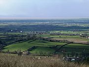
, an expanse of low-lying flat ground, which occupies an area between Weston-super-Mare
Weston-super-Mare
Weston-super-Mare is a seaside resort, town and civil parish in the unitary authority of North Somerset, which is within the ceremonial county of Somerset, England. It is located on the Bristol Channel coast, south west of Bristol, spanning the coast between the bounding high ground of Worlebury...
and Bristol
Bristol
Bristol is a city, unitary authority area and ceremonial county in South West England, with an estimated population of 433,100 for the unitary authority in 2009, and a surrounding Larger Urban Zone with an estimated 1,070,000 residents in 2007...
in North Somerset
North Somerset
North Somerset is a unitary authority in England. Its area covers part of the ceremonial county of Somerset but it is administered independently of the non-metropolitan county. Its administrative headquarters is in the town hall in Weston-super-Mare....
, England
England
England is a country that is part of the United Kingdom. It shares land borders with Scotland to the north and Wales to the west; the Irish Sea is to the north west, the Celtic Sea to the south west, with the North Sea to the east and the English Channel to the south separating it from continental...
. The River Banwell
River Banwell
The River Banwell is a small river in Somerset, England.It begins life as a series of springs near the Church of St Andrew in Banwell where they once filled a large pool below the church...
, River Kenn, River Yeo and Land Yeo
Land Yeo
The Land Yeo is a small river which flows through North Somerset, England.It rises on Dundry Hill and supplies Barrow Gurney Reservoirs before flowing through various villages to Clevedon where it drains into the Bristol Channel...
are the three principal rivers draining the area.
To the south the levels are bounded by the Mendip Hills
Mendip Hills
The Mendip Hills is a range of limestone hills to the south of Bristol and Bath in Somerset, England. Running east to west between Weston-super-Mare and Frome, the hills overlook the Somerset Levels to the south and the Avon Valley to the north...
, to the east by the Yeo Valley and the Lulsgate Plateau
Lulsgate Plateau
Lulsgate Plateau is the name given to the Carboniferous limestone hills which form a northern outlier of the Mendip Hills, southwest of Bristol, England, approximately above sea level, which has been occupied since prehistoric times....
, and to the north by the Tickenham Ridge. To the west lies the Severn Estuary
Severn Estuary
The Severn Estuary is the estuary of the River Severn, the longest river in Great Britain. Its high tidal range means it has been at the centre of discussions in the UK regarding renewable energy.-Geography:...
.
The levels are distinct from two similar areas: the much larger Somerset Levels
Somerset Levels
The Somerset Levels, or the Somerset Levels and Moors as they are less commonly but more correctly known, is a sparsely populated coastal plain and wetland area of central Somerset, South West England, between the Quantock and Mendip Hills...
to the south in Somerset
Somerset
The ceremonial and non-metropolitan county of Somerset in South West England borders Bristol and Gloucestershire to the north, Wiltshire to the east, Dorset to the south-east, and Devon to the south-west. It is partly bounded to the north and west by the Bristol Channel and the estuary of the...
, and the smaller Gordano Valley
Gordano Valley
Gordano is an area of North Somerset, in England. It has been designated as a National Nature Reserve.The name Gordano comes from Old English and is descriptive of the triangular shape of the whole valley from Clevedon to Portishead, being the ablative singular of the Latinised form of Gorden...
to the north.
The water level management and maintenance of rhyne
Rhyne
A rhyne , rhine/rhyne , or reen is a drainage ditch, or canal, used to turn areas of wetland at around sea level into useful pasture....
s in the area are the responsibility of the North Somerset Internal Drainage Board
Internal Drainage Board
An internal drainage board is a type of operating authority which is established in areas of special drainage need in England and Wales with permissive powers to undertake work to secure clean water drainage and water level management within drainage districts...
.
The term "Avon Levels" has also been used - either as a synonym for the North Somerset Levels, or to refer a larger area also including all of the other low-lying flat areas in the former county of Avon (e.g. the Gordano Valley and the areas around Severn Beach
Severn Beach
Severn Beach is a village on the mouth of the river Severn in South Gloucestershire, England. A riverside footpath, which is part of the Severn Way, leads beneath the Second Severn Crossing bridge...
and Avonmouth
Avonmouth
Avonmouth is a port and suburb of Bristol, England, located on the Severn Estuary, at the mouth of the River Avon.The council ward of Avonmouth also includes Shirehampton and the western end of Lawrence Weston.- Geography :...
)
Towns and villages on the North Somerset Levels
The following are the principal towns and villages in the area- Claverham
- CongresburyCongresburyCongresbury is a village and civil parish in Somerset, England. It is situated in the Unitary authority of North Somerset, and in 2001 had a population of 3,400. It lies on the A370, roughly equidistant between Junction 21 of the M5 and Bristol Airport, approximately south of Bristol city centre,...
- Hewish
- KennKenn, SomersetKenn is a small village and civil parish in county of Somerset, England. It falls within the area of the North Somerset unitary authority. It lies on the B3133 road near Clevedon in the North Somerset Levels...
- Kingston SeymourKingston SeymourKingston Seymour is a small village and civil parish in Somerset, England. It is situated within the unitary authority of North Somerset, between Clevedon and Weston-super-Mare on the North Somerset Levels. The parish has a population of 338...
- LockingLocking, North SomersetLocking is a village and civil parish in Somerset, England. It is a predominantly quiet residential area of North Somerset, south east of the town of Weston-super-Mare and houses a large farming contingent....
- NailseaNailseaNailsea is a town in the unitary authority of North Somerset within the ceremonial county of Somerset, England, approximately to the southwest of Bristol and about to the northeast of the seaside resort of Weston-super-Mare. The nearest village is Backwell, which lies south of Nailsea on the...
- PuxtonPuxtonPuxton is a village and civil parish, north west of Axbridge in the Unitary Authority of North Somerset within the ceremonial county of Somerset, England.The civil parish includes the isolated hamlets of East Hewish and West Hewish.-History:...
- Wick St Lawrence
- YattonYattonYatton is a village and civil parish within the unitary authority of North Somerset, which falls within the ceremonial county of Somerset, England. It is located south-west of Bristol. Its population in 2001 was 9,176...
Biodiversity
A number of areas of the Levels have been designated as Sites of Special Scientific Interest. Tickenham, Nailsea and Kenn Moors SSSITickenham, Nailsea and Kenn Moors SSSI
Tickenham, Nailsea and Kenn Moors SSSI is a 129.4 hectare biological Site of Special Scientific Interest between Tickenham, Nailsea and Kenn on the North Somerset Levels, notified in 1995....
is an extensive SSSI in the northern part of the Levels. Yanal Bog
Yanal Bog
Yanal Bog is a 1.6 hectare biological Site of Special Scientific Interest on the southern edge of the North Somerset Levels, just north of the village of Sandford, North Somerset. It was notified as an SSSI in 1988.-Site description:...
, a calcicolous mire
Bog
A bog, quagmire or mire is a wetland that accumulates acidic peat, a deposit of dead plant material—often mosses or, in Arctic climates, lichens....
near Sandford
Sandford, Somerset
Sandford is a village between Churchill and Banwell on the A368 in North Somerset, England.The Parish of Winscombe and Sandford, centred around the Parish Church of Saint James, includes the villages of Barton, Oakridge, Sandford, Sidcot and Woodborough....
is designated for its plant communities, within which grow Black Bog-rush (Schoenus
Schoenus (plant)
Schoenus is a genus of sedges. Plants of this genus mainly occur in Australasia.Species include:*Schoenus acuminatus*Schoenus andrewsii*Schoenus armeria*Schoenus badius*Schoenus benthamii*Schoenus capillifolius...
nigricans) and Blunt-flowered Rush (Juncus subnodulosus), two plant species rare in southwest England.
A number of plant species which are otherwise scarce or absent in the Bristol region are found in high concentrations on the North Somerset Levels, including Water Horsetail
Water Horsetail
The water horsetail , also known as the Swamp Horsetail, is a perennial horsetail that commonly grows in dense colonies along freshwater shorelines or in shallow water, growing in ponds, swamps, ditches, and other sluggish or still waters with mud bottoms...
(Equisetum fluviatile), Rigid (Ceratophyllum demersum) and Soft (C. submersum) hornworts, Thread-leaved (Ranunculus trichophyllus), Common (R. aquatilis) and Fan-leaved (R. circinatus) water-crowfoots, Lesser Water-parsnip (Berula erecta), Tubular (Oenanthe fistulosa) and Fine-leaved (O. aquatica) water-dropworts, Tufted Forget-me-not (Myosotis laxa ssp. caespitosa), Skullcap
Scutellaria
Scutellaria is a genus of flowering plants in the mint family, Lamiaceae. It contains about 300 species, which are commonly known as skullcaps...
and Fen Bedstraw. Water-violet (Hottonia palustris) is found here, mainly in the Nailsea & Tickenham areas, but also in scattered locations further south; this species is found nowhere else in the Bristol region. The introduced Water Fern Azolla filiculoides is widespread throughout.
Other plant species which are otherwise scarce or absent in the Bristol region but found in high concentrations on the North Somerset Levels are: Flowering-rush (Myles, p. 210), Lesser Water-plantain (Myles, p.210-1), Frogbit (Myles, p. 210-1), Lesser Pondweed (Myles, p.212-3), Small Pondweed (Myles, p. 212-3), Hairlike Pondweed (Myles, p213), Opposite-leaved Pondweed (Myles, p.213) and Horned Pondweed (Myles, p.213).
The introduced Canadian and Nuttall's Waterweeds are widespread throughout the levels (Myles p.211).