
North Franklin Mountain
Encyclopedia
Franklin Mountains (Texas)
The Franklin Mountains of Texas are a small range that extend from El Paso, Texas north into New Mexico. The Franklins were formed due to crustal extension related to the Cenozoic Rio Grande rift...
of El Paso, Texas
El Paso, Texas
El Paso, is a city in and the county seat of El Paso County, Texas, United States, and lies in far West Texas. In the 2010 census, the city had a population of 649,121. It is the sixth largest city in Texas and the 19th largest city in the United States...
, located in the Southwestern United States. North Franklin, at 7192 feet (2,192 m), is the highest point in El Paso, and the 27th-highest mountain in the state of
Texas. Surrounded by a state park
Franklin Mountains State Park
Franklin Mountains State Park is a Texas state park in El Paso, Texas in the United States. It is at an elevation of . It is the largest urban park in the nation lying completely within city limits, covering...
and with a maintained trail leading to its summit, the mountain is a popular hiking destination.
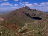
North Franklin is located entirely within the city of El Paso, approximately 10 miles (16.1 km) east of the Texas-New Mexico border and 15 miles (24.1 km) north of the U.S.-Mexico border. The mountain is the highest of the Franklins, clipping nearby Anthony's Nose by just over 200 feet (61 m) and neighboring South Franklin by nearly 300 feet (91.4 m). North Franklin rises 3300 feet (1,005.8 m) above both its western base in the Mesilla Valley
Mesilla Valley
The Mesilla Valley is a geographic feature of Southern New Mexico and far West Texas. It was formed by repeated heavy spring floods of the Rio Grande.The fertile Mesilla Valley extends from about Hatch, New Mexico to the west side of El Paso, Texas...
and its eastern base in the Hueco Bolson. In spite of its name, North Franklin is actually in the central Franklins, being the northernmost of the range's two key peaks (South Franklin, of course, is the other).
Like most of the Franklins, North Franklin Mountain is visible from many miles away. When observed from the east or west, North Franklin is shaped like a scalene triangle, with its long side facing its dome-shaped sister peak South Franklin Mountain (South Franklin is usually distinguished by the antennae adorning its summit). This quality makes it a valuable navigation point when traversing the desert areas around El Paso.
Geology
The Franklin Mountains are tilted-block fault mountains composed of sedimentary rocks, some of which date back to PrecambrianPrecambrian
The Precambrian is the name which describes the large span of time in Earth's history before the current Phanerozoic Eon, and is a Supereon divided into several eons of the geologic time scale...
times and are among the oldest in Texas. The mountains represent the southernmost tip of the Rocky Mountains
Rocky Mountains
The Rocky Mountains are a major mountain range in western North America. The Rocky Mountains stretch more than from the northernmost part of British Columbia, in western Canada, to New Mexico, in the southwestern United States...
in the U.S., and like the Rockies, were formed 60-70 million years ago during the Laramide orogeny
Laramide orogeny
The Laramide orogeny was a period of mountain building in western North America, which started in the Late Cretaceous, 70 to 80 million years ago, and ended 35 to 55 million years ago. The exact duration and ages of beginning and end of the orogeny are in dispute, as is the cause. The Laramide...
. The Precambrian rocks atop North Franklin Mountain represent "the highest geological structure in the state of Texas."
North Franklin gets its reddish color from the unusually-high levels of oxidized iron in the volcanic rocks coating its summit and higher slopes.
History
For centuries, Native Americans and other travellers have used the vegetation and wildlife in the Franklins when crossing the Paso del Norte—the gap between the Franklin Mountains and the Juarez Mountains that is now the site of Ciudad JuárezCiudad Juárez
Ciudad Juárez , officially known today as Heroica Ciudad Juárez, but abbreviated Juárez and formerly known as El Paso del Norte, is a city and seat of the municipality of Juárez in the Mexican state of Chihuahua. Juárez's estimated population is 1.5 million people. The city lies on the Rio Grande...
and El Paso. Pictographs and mortar pits attest to a human presence in the mountains dating back more than 12,000 years.
The Franklin Mountains are probably named after Benjamin Franklin Coons, who in 1849 purchased a ranch in what is now the El Paso area. Initially known as Coons Ranch, by 1851 the settlement had apparently taken Coons' middle name and was called "Franklin".
Despite the town being officially named El Paso in 1852, the locals continued to call it Franklin throughout the 1850s.
The El Paso Tin Mining and Smelting Company operated a tin mine on the northeast slope of North Franklin from 1909-1915. While the mine had the distinction of being the only tin mine ever located in the U.S., the venture was an economic failure. Today, a trail leading to the ruins of the mine forks off the North Franklin Peak Trail, just past Mundy's Gap.
Access
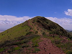
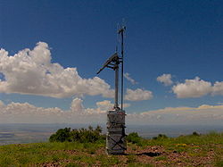
The Mundy's Gap Trail rises out of the Tom Mays section of Franklin Mountains State Park and winds 1.6 miles (2.6 km) to Mundy's Gap, on the north slope of North Franklin Mountain. From Mundy's Gap, the North Franklin Peak Trail follows the mountain's eastern slope for approximately three miles to the summit. Various spur trails branch off the main trail along the way.The summit of North Franklin has been flattened out, with an area equal to the size of a small parking lot. The only man-made structure at the summit is a 10 feet (3 m) ham radio
Amateur radio operator
An amateur radio operator is an individual who typically uses equipment at an amateur radio station to engage in two-way personal communications with other similar individuals on radio frequencies assigned to the amateur radio service. Amateur radio operators have been granted an amateur radio...
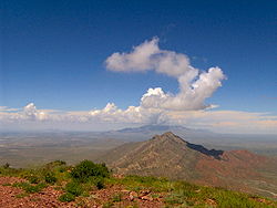
repeater and ELT receiver maintained by the West Texas Repeater Association. On a typical day, the Organ Mountains
Organ Mountains
The Organ Mountains are a rugged mountain range in southern New Mexico in the Southwestern United States. They lie east of the city of Las Cruces, in Doña Ana County.-Geography:...
of New Mexico can be seen along the horizon to the north. To the east, the Guadalupe Mountains
Guadalupe Mountains
The Guadalupe Mountains are a mountain range located in West Texas and southeastern New Mexico. The range includes the highest summit in Texas, Guadalupe Peak, , and the "signature peak" of West Texas, El Capitan, both located within Guadalupe Mountains National Park, as well as Carlsbad Caverns...
rise some 100 miles (160.9 km) in the distance. Most of the Mesilla Valley
Mesilla Valley
The Mesilla Valley is a geographic feature of Southern New Mexico and far West Texas. It was formed by repeated heavy spring floods of the Rio Grande.The fertile Mesilla Valley extends from about Hatch, New Mexico to the west side of El Paso, Texas...
is visible to the west, including parts of El Paso and Ciudad Juárez
Ciudad Juárez
Ciudad Juárez , officially known today as Heroica Ciudad Juárez, but abbreviated Juárez and formerly known as El Paso del Norte, is a city and seat of the municipality of Juárez in the Mexican state of Chihuahua. Juárez's estimated population is 1.5 million people. The city lies on the Rio Grande...
, and most of the town of Anthony
Anthony, New Mexico
Anthony is a city in Doña Ana County, New Mexico, USA. The population was 7,904 at the 2000 census. It is located on the New Mexico–Texas state line in the Upper Mesilla Valley, and on Interstate 10, 27 miles south of Las Cruces and 21 miles north of El Paso, Texas...
. South Franklin Mountain and the Juarez Mountains are to the south.
External links
- Franklin Mountains State Park, Tom Mays Unit, trail map
- North Franklin Mountain - SummitPost.org
- Geology of the Franklin Mountains - Hosted by the University of Texas-El Paso
- West Texas Repeater Association - The WTRA maintains the repeater atop North Franklin