
Nore og Uvdal
Encyclopedia
Nore og Uvdal is a municipality in Buskerud
county
, Norway
. It is part of the traditional region
of Numedal
. The administrative centre of the municipality is the village of Rødberg
.
The area of Nore was separated from the municipality of Rollag
in 1858. The municipality of Nore was divided into two municipalities on 1 January 1901: Nore and Uvdal
. These two municipalities were merged back together on 1 January 1962, and the new municipality was called Nore og Uvdal.
and Uvdal
were joined together in 1962 into Nore og Uvdal.
The Old Norse
form of Nore was Nórar. The name is the plural
form of nór which means "narrow sound
or strait
". The name originally belonged to the vicarage
(and church site) at Norefjorden
.
The Old Norse form of Uvdal was Uppdalr. The first element is upp meaning "upper" or "high" and the last element is dalr which means "valley
" or "dale". The name originally belonged to the vicarage and old church site. Prior to 1933, the name was spelled "Opdal".
is from modern times. They were granted on 26 March 1982. The arms are divided
diagonally with the colors green on yellow above the line and yellow on green below. The economy of the municipality is based on agriculture
and forestry
. Hence the upper half of the arms shows a barn for the storage of grains and the lower half a watermill
wheel which was used to saw tree
s.
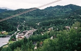
 The municipal centre is the village of Rødberg. Nore and Uvdal
are the two other villages in the municipality.
Nore og Uvdal is bordered in the north by the municipalities of Hol
, Ål
, and Nes
; in the east by Flå
and Sigdal
; in the south by Rollag
, Tinn
, and Vinje
(the latter two in Telemark
county); and in the west by Eidfjord
(in Hordaland
county).
The municipality is located at the top of the valley and traditional district of Numedal
, with a widely spread area of 2505 square kilometre. The municipality’s highest point is the Borgsjåbrot mountain at 1485 metres (4,872 ft). It is located on the border with Tinn
municipality in Telemark county. A large part of the Hardangervidda
lies within the municipality's borders.
Lakes in the municipality include Geitsjøen
and Hettefjorden
.
with Nore og Uvdal: Juupajoki
, Western Finland, Finland
Surahammar
, Västmanland County
, Sweden
Wahlstedt
, Schleswig-Holstein
, Germany
Buskerud
is a county in Norway, bordering Akershus, Oslo, Oppland, Sogn og Fjordane, Hordaland, Telemark, and Vestfold. The county administration is located in Drammen.-Geography:...
county
Counties of Norway
Norway is divided into 19 administrative regions, called counties . The counties form the primary first-level subdivisions of Norway and are further divided into 430 municipalities...
, Norway
Norway
Norway , officially the Kingdom of Norway, is a Nordic unitary constitutional monarchy whose territory comprises the western portion of the Scandinavian Peninsula, Jan Mayen, and the Arctic archipelago of Svalbard and Bouvet Island. Norway has a total area of and a population of about 4.9 million...
. It is part of the traditional region
Districts of Norway
The country Norway is historically divided into a number of districts. Many districts have deep historical roots, and only partially coincide with today's administrative units of counties and municipalities. The districts are defined by geographical features, often valleys, mountain ranges, fjords,...
of Numedal
Numedal
Numedal is a traditional district and valley Buskerud, Norway. Running north–south, it extends between Kongsberg in the south to Rødberg in the north, passing through the municipalities of Kongsberg, Flesberg, Rollag and Nore og Uvdal.. The river Numedalslågen, the third-longest in the country,...
. The administrative centre of the municipality is the village of Rødberg
Rødberg
Rødberg is the administrative centre of Nore og Uvdal municipality, Norway.Rødberg is located in the Norwegian traditional district and valley of Numedal. Its population is 468, and it is located on the Rødberg dam on the Numedalslågen River....
.
The area of Nore was separated from the municipality of Rollag
Rollag
Rollag is a municipality in Buskerud county, Norway. It is part of the traditional region of Numedal. The municipality of Rollag was established on 1 January 1838 . Nore og Uvdal was separated from Rollag in 1858....
in 1858. The municipality of Nore was divided into two municipalities on 1 January 1901: Nore and Uvdal
Uvdal
Uvdal is a village and former municipality in Buskerud county, Norway.The municipality was created by a split from Nore on 1 January 1901. The new municipality, which was called Opdal at the time, had a population of 1,429. The name was changed to Uvdal on 22 January 1932 by royal resolution...
. These two municipalities were merged back together on 1 January 1962, and the new municipality was called Nore og Uvdal.
Name
The municipalities of NoreNore
The Nore is a sandbank at the mouth of the Thames Estuary, England. It marks the point where the River Thames meets the North Sea, roughly halfway between Havengore Creek in Essex and Warden Point in Kent....
and Uvdal
Uvdal
Uvdal is a village and former municipality in Buskerud county, Norway.The municipality was created by a split from Nore on 1 January 1901. The new municipality, which was called Opdal at the time, had a population of 1,429. The name was changed to Uvdal on 22 January 1932 by royal resolution...
were joined together in 1962 into Nore og Uvdal.
The Old Norse
Old Norse
Old Norse is a North Germanic language that was spoken by inhabitants of Scandinavia and inhabitants of their overseas settlements during the Viking Age, until about 1300....
form of Nore was Nórar. The name is the plural
Plural
In linguistics, plurality or [a] plural is a concept of quantity representing a value of more-than-one. Typically applied to nouns, a plural word or marker is used to distinguish a value other than the default quantity of a noun, which is typically one...
form of nór which means "narrow sound
Sound (geography)
In geography a sound or seaway is a large sea or ocean inlet larger than a bay, deeper than a bight and wider than a fjord; or it may be defined as a narrow sea or ocean channel between two bodies of land ....
or strait
Strait
A strait or straits is a narrow, typically navigable channel of water that connects two larger, navigable bodies of water. It most commonly refers to a channel of water that lies between two land masses, but it may also refer to a navigable channel through a body of water that is otherwise not...
". The name originally belonged to the vicarage
Rectory
A rectory is the residence, or former residence, of a rector, most often a Christian cleric, but in some cases an academic rector or other person with that title...
(and church site) at Norefjorden
Norefjorden
Norefjorden is a lake in the municipality of Nore og Uvdal in Buskerud county, Norway....
.
The Old Norse form of Uvdal was Uppdalr. The first element is upp meaning "upper" or "high" and the last element is dalr which means "valley
Valley
In geology, a valley or dale is a depression with predominant extent in one direction. A very deep river valley may be called a canyon or gorge.The terms U-shaped and V-shaped are descriptive terms of geography to characterize the form of valleys...
" or "dale". The name originally belonged to the vicarage and old church site. Prior to 1933, the name was spelled "Opdal".
Coat-of-arms
The coat-of-armsCoat of arms
A coat of arms is a unique heraldic design on a shield or escutcheon or on a surcoat or tabard used to cover and protect armour and to identify the wearer. Thus the term is often stated as "coat-armour", because it was anciently displayed on the front of a coat of cloth...
is from modern times. They were granted on 26 March 1982. The arms are divided
Division of the field
In heraldry, the field of a shield can be divided into more than one area of different tinctures, usually following the lines of one of the ordinaries and carrying its name...
diagonally with the colors green on yellow above the line and yellow on green below. The economy of the municipality is based on agriculture
Agriculture
Agriculture is the cultivation of animals, plants, fungi and other life forms for food, fiber, and other products used to sustain life. Agriculture was the key implement in the rise of sedentary human civilization, whereby farming of domesticated species created food surpluses that nurtured the...
and forestry
Forestry
Forestry is the interdisciplinary profession embracing the science, art, and craft of creating, managing, using, and conserving forests and associated resources in a sustainable manner to meet desired goals, needs, and values for human benefit. Forestry is practiced in plantations and natural stands...
. Hence the upper half of the arms shows a barn for the storage of grains and the lower half a watermill
Watermill
A watermill is a structure that uses a water wheel or turbine to drive a mechanical process such as flour, lumber or textile production, or metal shaping .- History :...
wheel which was used to saw tree
Tree
A tree is a perennial woody plant. It is most often defined as a woody plant that has many secondary branches supported clear of the ground on a single main stem or trunk with clear apical dominance. A minimum height specification at maturity is cited by some authors, varying from 3 m to...
s.
Geography
Uvdal
Uvdal is a village and former municipality in Buskerud county, Norway.The municipality was created by a split from Nore on 1 January 1901. The new municipality, which was called Opdal at the time, had a population of 1,429. The name was changed to Uvdal on 22 January 1932 by royal resolution...
are the two other villages in the municipality.
Nore og Uvdal is bordered in the north by the municipalities of Hol
Hol
Hol is a municipality in Buskerud county, Norway.-Administrative history:The area of Hol was separated from the municipality of Ål in 1877 to become a separate municipality. In 1937 a part of neighboring Uvdal with 220 inhabitants was moved to Hol municipality. The area of Dagali was transferred...
, Ål
Ål
Ål is a municipality in Buskerud county, Norway. It is part of the traditional region of Hallingdal. The administrative centre of the municipality is the village of Ål....
, and Nes
Nes, Buskerud
Nes is a municipality in Buskerud county, Norway. It is part of the traditional region of Hallingdal. The administrative centre of the municipality is the village of Nesbyen....
; in the east by Flå
Flå
Flå is a municipality in Buskerud county, Norway. The administrative centre of the municipality is the village of Flå. The municipality of Flå was established when it was separated from the municipality of Nes on 1 January 1905...
and Sigdal
Sigdal
Sigdal is a municipality in Buskerud county, Norway. The administrative centre of the municipality is the village of Prestfoss. -Background:...
; in the south by Rollag
Rollag
Rollag is a municipality in Buskerud county, Norway. It is part of the traditional region of Numedal. The municipality of Rollag was established on 1 January 1838 . Nore og Uvdal was separated from Rollag in 1858....
, Tinn
Tinn
Tinn is a municipality in Telemark county, Norway. It is part of the traditional region of Øst-Telemark. The administrative centre of the municipality is the town of Rjukan....
, and Vinje
Vinje
Vinje is a municipality in Telemark county, Norway. It is part of the traditional region of Vest-Telemark. The administrative center of the municipality is the village of Åmot.-Name:...
(the latter two in Telemark
Telemark
is a county in Norway, bordering Vestfold, Buskerud, Hordaland, Rogaland and Aust-Agder. The county administration is in Skien. Until 1919 the county was known as Bratsberg amt.-Location:...
county); and in the west by Eidfjord
Eidfjord
Eidfjord is a municipality in the county of Hordaland, Norway. Eidfjord was separated from Ulvik May 1, 1891....
(in Hordaland
Hordaland
is a county in Norway, bordering Sogn og Fjordane, Buskerud, Telemark and Rogaland. Hordaland is the third largest county after Akershus and Oslo by population. The county administration is located in Bergen...
county).
The municipality is located at the top of the valley and traditional district of Numedal
Numedal
Numedal is a traditional district and valley Buskerud, Norway. Running north–south, it extends between Kongsberg in the south to Rødberg in the north, passing through the municipalities of Kongsberg, Flesberg, Rollag and Nore og Uvdal.. The river Numedalslågen, the third-longest in the country,...
, with a widely spread area of 2505 square kilometre. The municipality’s highest point is the Borgsjåbrot mountain at 1485 metres (4,872 ft). It is located on the border with Tinn
Tinn
Tinn is a municipality in Telemark county, Norway. It is part of the traditional region of Øst-Telemark. The administrative centre of the municipality is the town of Rjukan....
municipality in Telemark county. A large part of the Hardangervidda
Hardangervidda
The Hardangervidda is a mountain plateau in the Hardanger region of western Norway. It is the largest such plateau in Europe, with a cold year-round alpine climate and is the site of one of Norway's largest glaciers. Much of the plateau is protected as part of Hardangervidda National Park; it is a...
lies within the municipality's borders.
Lakes in the municipality include Geitsjøen
Geitsjøen
Geitsjøen is a lake in the municipality of Nore og Uvdal in Buskerud county, Norway....
and Hettefjorden
Hettefjorden
Hettefjorden is a lake in the municipality of Nore og Uvdal in Buskerud county, Norway....
.
Attractions
- Langedrag Fjellgård (Langedrag Mountain Farm) - a resort in the mountain focusing on ecology and animals
- Uvdal Skisenter - an alpine resort located in Uvdal
- Uvdal Alpinpark - another alpine resort located in Uvdal, on the other side of the valley
- Nore stave churchNore stave churchNore Stave Church is a stave church located at Nore in Nore og Uvdal, Norway.-Description:Dendrochronological dating of wood samples indicate that Nore stave church was built after 1167. The church was built with galleries, a chancel and cross naves - an architectural style that was unique in...
(built around 1166 - 1200) - Uvdal Stave ChurchUvdal Stave ChurchUvdal Stave Church is situated at Uvdal in Nore and Uvdal municipality, which is in the valley Numedal in Norway. The stave church was originally constructed just after the year 1168, which we know through dendrochronological dating of the pine tree used during the construction...
, a stave churchStave churchA stave church is a medieval wooden church with a post and beam construction related to timber framing. The wall frames are filled with vertical planks. The load-bearing posts have lent their name to the building technique...
originally constructed just after the year 1168
Sister cities
The following cities are twinnedTown twinning
Twin towns and sister cities are two of many terms used to describe the cooperative agreements between towns, cities, and even counties in geographically and politically distinct areas to promote cultural and commercial ties.- Terminology :...
with Nore og Uvdal: Juupajoki
Juupajoki
Juupajoki is a municipality of Finland.It is located in the province of Western Finland and is part of the Pirkanmaa region. The municipality has a population of and covers an area of of which is water. The population density is ....
, Western Finland, Finland
Finland
Finland , officially the Republic of Finland, is a Nordic country situated in the Fennoscandian region of Northern Europe. It is bordered by Sweden in the west, Norway in the north and Russia in the east, while Estonia lies to its south across the Gulf of Finland.Around 5.4 million people reside...
Surahammar
Surahammar Municipality
Surahammar Municipality is a municipality in Västmanland County in central Sweden. Its seat is located in the town of Surahammar....
, Västmanland County
Västmanland County
Västmanland County is a county or län in central Sweden. It borders to the counties of Södermanland, Örebro, Gävleborg, Dalarna and Uppsala...
, Sweden
Sweden
Sweden , officially the Kingdom of Sweden , is a Nordic country on the Scandinavian Peninsula in Northern Europe. Sweden borders with Norway and Finland and is connected to Denmark by a bridge-tunnel across the Öresund....
Wahlstedt
Wahlstedt
Wahlstedt is a town in the district of Segeberg in Schleswig-Holstein, Germany.-Geography:The town lies about 50 km north of Hamburg, 40 km south of Kiel and 30 km west of Lübeck...
, Schleswig-Holstein
Schleswig-Holstein
Schleswig-Holstein is the northernmost of the sixteen states of Germany, comprising most of the historical duchy of Holstein and the southern part of the former Duchy of Schleswig...
, Germany
Germany
Germany , officially the Federal Republic of Germany , is a federal parliamentary republic in Europe. The country consists of 16 states while the capital and largest city is Berlin. Germany covers an area of 357,021 km2 and has a largely temperate seasonal climate...
External links
- Municipal fact sheet from Statistics NorwayStatistics NorwayStatistics Norway is the Norwegian statistics bureau. It was established in 1876.Relying on a staff of about 1,000, Statistics Norway publish about 1,000 new statistical releases every year on its web site. All releases are published both in Norwegian and English...
- Nore og Uvdal kommune
- Map of Nore og Uvdal showing points of culture from Kulturnett.no
- EKT Langedrag Naturpark
- Uvdal - official visitor information