

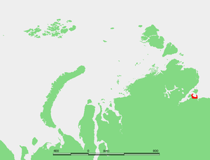
Nordvik Bay
Encyclopedia
Laptev Sea
The Laptev Sea is a marginal sea of the Arctic Ocean. It is located between the northern coast of Siberia, the Taimyr Peninsula, Severnaya Zemlya and the New Siberian Islands. Its northern boundary passes from the Arctic Cape to a point with co-ordinates of 79°N and 139°E, and ends at the Anisiy...
. Lat 73° 45' and long 112°. It is located Southeast of the mouth of the Khatanga Gulf
Khatanga Gulf
The Khatanga Gulf or Khatanga Bay is a large tidal estuary in the Laptev Sea. It is relatively narrow, its length being 220 km with a maximum width of 54 km....
, between two small peninsulas. The landspit in the west is the Uryung Tumus Peninsula, where there was formerly a village called Nordvik
Nordvik (Laptev Sea)
Nordvik was a harbor-port in the Khatanga Gulf at the mouth of the Khatanga River. It was located on the Uryung Tumus Peninsula, west of a bay called Nordvik Bay . Formerly there was a small town and a penal colony next to the harbour, called Nordvik...
and an infamous penal colony
Gulag
The Gulag was the government agency that administered the main Soviet forced labor camp systems. While the camps housed a wide range of convicts, from petty criminals to political prisoners, large numbers were convicted by simplified procedures, such as NKVD troikas and other instruments of...
that lies now deserted. The peninsula in the east is called Nordvik Peninsula, with Cape Paksa at its northern end, and on its eastern side lies the Anabar Bay
Anabar Bay
Anabar Bay is a gulf in the Laptev Sea. Lat 74° 30' and long 113° 15'. It stretches between the eastern cape off the mouth of the Anabar River and the Nordvik Peninsula. Nordvik Bay lies further west of it, beyond Cape Paksa at the tip of the peninsula.Anabar Bay opens towards the north and it is...
.
During the 1930s this area experienced a limited boom owing to the first icebreaker convoys plying the Northern Sea Route
Northern Sea Route
The Northern Sea Route is a shipping lane officially defined by Russian legislation from the Atlantic Ocean to the Pacific Ocean specifically running along the Russian Arctic coast from Murmansk on the Barents Sea, along Siberia, to the Bering Strait and Far East. The entire route lies in Arctic...
. Tiksi Bay
Tiksi
Tiksi is an urban locality and the administrative center of Bulunsky District of the Sakha Republic, Russia, situated on the Arctic Ocean coast. Population: It is one of the principal ports for accessing the Laptev Sea...
and Mys Schmidta
Mys Shmidta Airport
Mys Shmidta Airport , also known as Cape Shmidt Airport, is a former military airbase in the Shmidtovsky District of Chukotka, Russia. It is located southeast of Mys Shmidta....
had become airports and Nordvik was "a growing town."
Nordvik Bay is 39 km wide and it has a regular semicircular shape. It is quite shallow, its average depth being around 6 m. It is circled by lowlands and, since the climate in the area is exceptionally severe, with prolonged, bitter winters, Nordvik Bay is covered by ice most of the year.
Nordvik Bay and most of its surrounding area belongs to the Sakha Republic administrative division of the Russian Federation.