
Newton, New Zealand
Encyclopedia
Newton is a small suburb of Auckland City
, New Zealand
, under the local governance of the Auckland City Council
. It had a population of 837 in the 2001 census.
Since the construction of the Central Motorway Junction
in 1965–75, Newton has been divided into two parts, and as a result, lost much of its size and coherence. The northern part is centred on Karangahape Road
, and the southern part on Newton Road. Both Karangahape and Newton Roads intersect with Symonds Street to the east. Newton Road joins the Great North/Ponsonby and Karangahape Road intersection to the west.
At the southern end of Symonds Street are the Symonds Street Shops. Here Upper Symonds Street has two major intersections with other arterial roads: Newton Road and Khyber Pass Road, and Mt Eden Road and New North Road.
(1810–41), an officer of the 96th Regiment of Foot of the British Army. He came to New Zealand in the early 1830s as agent of the Waitemata and Manukau Land Company and was instrumental in the founding of Auckland and the signing of the Treaty of Waitangi
. He was one of Governor William Hobson
's closest and most effective officials and was one of the first six Police Magistrates in New Zealand as well as Chief Magistrate of Auckland and Deputy Surveyor of New Zealand. During 1841 Symonds accompanied the naturalist Ernst Dieffenbach
in his survey of the North Island
. Capt Symonds died on 23 November 1841 in a boating accident on the Manukau Harbour
. Following his death his brother John continued to live in the colony; Symonds Street in Onehunga
is named after John Cornwallis Symonds.
Before the 1870s there were several brick works in Newton Gully which later relocated to New Lynn; a great many 19th century bricks found in Auckland bear the imprint "Newton". From the 1890s onwards it was the location of many small scale industries: bicycle manufacturing, shirt, clothing and boot factories, upholstery, rattan furniture and basket manufacturing etc.
Situated between the retail areas of Karangahape Road and Symonds Street, Newton was a fairly densely populated suburb, mainly of a working class nature with many boarding houses. Until the construction of the motorway system in the 1960s, the gully area was the location of several primary and intermediate level schools and about six churches.
After the motorway was cut through, much of the remaining housing stock was utilised for light industrial use and often rebuilt as factories and warehouses. Since the 1990s there has been a reverse trend of rebuilding or converting industrial buildings for residential use including some large apartment blocks.
, St Peter's College
and Saint Mary's College
. St Benedict's College (opened in 1886 in St Benedict's St) closed down in 1980 and was demolished. Its secondary department merged with Marcellin College
, Royal Oak
.
Auckland City
Auckland City was the city and local authority covering the Auckland isthmus and most of the islands of the Hauraki Gulf, in the North Island of New Zealand. On 1 November 2010 it was amalgamated into the wider Auckland Region under the authority of the new Auckland Council...
, New Zealand
New Zealand
New Zealand is an island country in the south-western Pacific Ocean comprising two main landmasses and numerous smaller islands. The country is situated some east of Australia across the Tasman Sea, and roughly south of the Pacific island nations of New Caledonia, Fiji, and Tonga...
, under the local governance of the Auckland City Council
Auckland City Council
Auckland City Council was the local government authority representing Auckland City, New Zealand, and was amalgamated into the Auckland Council on 1 November 2010. It was an elected body representing the 404,658 residents of the city...
. It had a population of 837 in the 2001 census.
Since the construction of the Central Motorway Junction
Central Motorway Junction
The Central Motorway Junction or CMJ , is the intersection of New Zealand State Highways 1 and 16, just south of the central business district of Auckland, New Zealand...
in 1965–75, Newton has been divided into two parts, and as a result, lost much of its size and coherence. The northern part is centred on Karangahape Road
Karangahape Road
Karangahape Road is one of the main streets in the central business district of Auckland, New Zealand. The massive expansion of motorways through the nearby inner city area - and subsequent flight of residents and retail into the suburbs - turned it from one of Auckland's premier shopping streets...
, and the southern part on Newton Road. Both Karangahape and Newton Roads intersect with Symonds Street to the east. Newton Road joins the Great North/Ponsonby and Karangahape Road intersection to the west.
At the southern end of Symonds Street are the Symonds Street Shops. Here Upper Symonds Street has two major intersections with other arterial roads: Newton Road and Khyber Pass Road, and Mt Eden Road and New North Road.
History
Historically, the suburb did not always have a good reputation. A 1920s newspaper described it as a "haunt of many of Auckland's best-known crooks".Symonds Street
Symonds Street is named after Captain William Cornwallis SymondsWilliam Cornwallis Symonds
Captain William Cornwallis Symonds was a British Army officer who was prominent in the early colonisation of New Zealand. He was the eldest son of William Symonds, Surveyor of the Navy....
(1810–41), an officer of the 96th Regiment of Foot of the British Army. He came to New Zealand in the early 1830s as agent of the Waitemata and Manukau Land Company and was instrumental in the founding of Auckland and the signing of the Treaty of Waitangi
Treaty of Waitangi
The Treaty of Waitangi is a treaty first signed on 6 February 1840 by representatives of the British Crown and various Māori chiefs from the North Island of New Zealand....
. He was one of Governor William Hobson
William Hobson
Captain William Hobson RN was the first Governor of New Zealand and co-author of the Treaty of Waitangi.-Early life:...
's closest and most effective officials and was one of the first six Police Magistrates in New Zealand as well as Chief Magistrate of Auckland and Deputy Surveyor of New Zealand. During 1841 Symonds accompanied the naturalist Ernst Dieffenbach
Ernst Dieffenbach
Johann Karl Ernst Dieffenbach was a German physician, geologist and naturalist, the first trained scientist to live and work in New Zealand, where he travelled widely under the auspices of the New Zealand Company, returning in 1841–42 and publishing in English his Travels in New Zealand in...
in his survey of the North Island
North Island
The North Island is one of the two main islands of New Zealand, separated from the much less populous South Island by Cook Strait. The island is in area, making it the world's 14th-largest island...
. Capt Symonds died on 23 November 1841 in a boating accident on the Manukau Harbour
Manukau Harbour
Manukau Harbour is the second largest natural harbour in New Zealand by area. It is located to the southwest of the Auckland isthmus, and is an arm of the Tasman Sea.-Geography:...
. Following his death his brother John continued to live in the colony; Symonds Street in Onehunga
Onehunga
Onehunga is a suburb of Auckland City, New Zealand and the location of the Port of Onehunga, the city's small port on the Manukau Harbour. It is eight kilometres south of the city centre, close to the volcanic cone of One Tree Hill, Maungakiekie....
is named after John Cornwallis Symonds.
Before the 1870s there were several brick works in Newton Gully which later relocated to New Lynn; a great many 19th century bricks found in Auckland bear the imprint "Newton". From the 1890s onwards it was the location of many small scale industries: bicycle manufacturing, shirt, clothing and boot factories, upholstery, rattan furniture and basket manufacturing etc.
Situated between the retail areas of Karangahape Road and Symonds Street, Newton was a fairly densely populated suburb, mainly of a working class nature with many boarding houses. Until the construction of the motorway system in the 1960s, the gully area was the location of several primary and intermediate level schools and about six churches.
After the motorway was cut through, much of the remaining housing stock was utilised for light industrial use and often rebuilt as factories and warehouses. Since the 1990s there has been a reverse trend of rebuilding or converting industrial buildings for residential use including some large apartment blocks.
Buildings of interest
- Saint Benedicts Roman Catholic Church, St Benedicts Street. This brick church in the Flemish Gothic style dates from 1886 and replaces an earlier wooden church which burnt down. Both churches were by Auckland architect Edward Mahoney. The original design included a bell tower with spire which was never constructed. To the south of the church is a brick Gothic presbytery. On the east side of St Benedicts Street, opposite the church, is a two-storied brick house for an order of nuns.
- Freemasons Hall, St Benedicts Street. This is a large and imposing 1920s building in the neo-classical style. Architects: Chilwell & Trevithick.
- The Stables. This 19th century wood-frame building clad in corrugated iron is at the end of Stable Lane. It was built as Livery Stables for the Winstone company. Recently registered by the Auckland City Council as a heritage building, the Stables has been renovated as part of a new building complex called "Site Three".
- Site Three, St Benedicts Street. A modern development including commercial offices and a cafe. It is regarded as an architectural gem, Urbis magazine's Melinda Williams referred to the "strikingly graceful concrete lines of Andrew Patterson's award winning Site Three development".
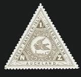
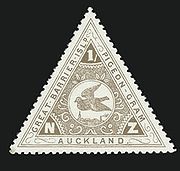
- Pigeon Post HousePigeon Post HouseThe Pigeon Post House is located at 112 Newton Road, Newton, Auckland, New Zealand, on the corner of Newton Road and Upper Queen Street.From 1897 into the early 20th century the building was used as a pigeon-carrier postal service between Great Barrier Island and Auckland...
. On the corner of Upper Queen St and Newton Road is a small wooden Victorian house. Unremarkable in itself, this is one of the very few original houses remaining in the area. It was the office of Mr Holden Howie's pigeon postPigeon postPigeon post is the use of homing pigeons to carry messages. Pigeons were effective as messengers due to their natural homing abilities. The pigeons were transported to a destination in cages, where they would be attached with messages, then naturally the pigeon would fly back to its home where the...
service to Great Barrier IslandGreat Barrier IslandGreat Barrier Island is a large island of New Zealand, situated to the north-east of central Auckland in the outer Hauraki Gulf. With an area of it is the fourth-largest island of New Zealand's main chain of islands, with its highest point, Mount Hobson, rising...
, possibly the first regular air mail service in the world (1896). Certainly the world’s first 'airmail' stamps were issued for the Great Barrier Pigeon-Gram Service from 1898 to 1908. Next to the house stood large aviaries housing the birds. http://www.tepapa.govt.nz/wings/pigeons3.htm
- Orange Coronation Ballroom. Located at the top of Newton Road is an interesting minor gem of interwar stripped classicism. Architect: Sinclair O'Conner.
- Edinburgh Castle Hotel, corner of Symonds Street and Newton Road. This is an example of a 19th century pub in one of the simpler versions of the Italianate style.
- Former ASB Bank, Khyber Pass Road. Architect: Daniel B. Patterson. This small neo-classical building is one of the many buildings commissioned by the Auckland Savings BankASB BankASB is a New Zealand bank owned by the Commonwealth Bank of Australia, which is listed on the Australian Stock Exchange. It is one of the largest New Zealand banks, with branches throughout the country. It operates BankDirect, a branchless banking service that provides service via phone, Internet,...
from the architect Daniel B. Patterson. Similar buildings appear in Auckland suburban centres and in provincial towns throughout the Auckland ProvinceAuckland ProvinceThe Auckland Province was a province of New Zealand from 1853 until the abolition of provincial government in 1876.-Anniversary Day:...
.
- Church of the Holy Sepulchre, Khyber Pass Road. Built in 1880 to the designs of Edward Mahoney, this Anglican church has one of the best wooden church interiors in the world.
- Presbyterian Church of St David, opposite the Holy Sepulchre, Khyber Pass Road. This is a brick building from 1909 which replaced an earlier wooden Gothic church by Edward BartleyEdward BartleyEdward Bartley was an architect from New Zealand. He was born in Saint Helier, Jersey, Channel Islands. He arrived in New Zealand 1854...
.
- Former Post Office building. This fine Art DecoArt DecoArt deco , or deco, is an eclectic artistic and design style that began in Paris in the 1920s and flourished internationally throughout the 1930s, into the World War II era. The style influenced all areas of design, including architecture and interior design, industrial design, fashion and...
structure from the 1930s is also located in Upper Symonds Street.
- Former Grafton Public Library. This elegant Edwardian building in the classical style is just around the corner on Mt Eden Road and opened in March 1913. Architect: Edward Bartley.
- Former Eden Vale Hotel. At the intersection of Mt Eden Road, New North Road and Symonds Street is a building that for many years was the premises of W.H.Tongue, a firm of undertakers. The building was built as the Eden Vale Hotel, but soon after it was finished the inhabitants of Mt Eden voted for the area to become dry. As the building was just within the boundaries of Mt Eden it could not continue to be used as a licenced hotel. The other two pubs in the Upper Symonds Street area were both safely within Auckland City: the Astor Hotel (demolished; corner Khyber Pass Road and Symonds St) and the Edinburgh Castle Hotel (extant; corner Newton Road and Symonds Street).
Education
Local secondary schools include Auckland Girls Grammar School, Mount Albert Grammar SchoolMount Albert Grammar School
Mount Albert Grammar School, or MAGS, is a co-educational secondary school in Central Auckland, New Zealand. It teaches from year 9 to year 13. Mount Albert Grammar is one of the largest secondary schools in the country...
, St Peter's College
St Peter's College, Auckland
St Peter's College is a Catholic college for year 7 to 13 boys . The school, located in Auckland, is one of the largest Catholic schools in New Zealand and is an integrated school under an integration agreement entered into by the Catholic Bishop of Auckland and the Government of New Zealand in...
and Saint Mary's College
Saint Mary's College Auckland
St Mary's College is a year 7 - 13 integrated Catholic girls' high school situated at 11 New Street, Ponsonby, Auckland.-History:St Mary’s College is the oldest existing secondary school for girls in Auckland and one of the oldest existing schools in New Zealand...
. St Benedict's College (opened in 1886 in St Benedict's St) closed down in 1980 and was demolished. Its secondary department merged with Marcellin College
Marcellin College, Auckland
Marcellin College is an integrated, co-educational college in Royal Oak, Auckland, New Zealand for students in Year 7 to Year 13. Marcellin College was founded by the Marist Brothers in 1958 as a secondary school for boys only. The school is located on spacious grounds which were formerly part of...
, Royal Oak
Royal Oak
The Royal Oak is the English oak tree within which King Charles II of England hid to escape the Roundheads following the Battle of Worcester in 1651. The tree was located in Boscobel Wood, which was part of the park of Boscobel House. Charles confirmed to Samuel Pepys in 1680 that while he was...
.