

New Zealand State Highway 67
Encyclopedia
State Highway 67 is a New Zealand
State Highway
located in the northern parts of the South Island
of New Zealand
. It is 51.2 km long and connects State Highway 6
with the settlement of Mokihinui
. It used to be 96 kilometres long and ran the entire length of the road to Karamea
. The highway and its spur serves the large West Coast
town of Westport
and lies entirely within the Buller District
.
to enter the township of Westport
. Once in the CBD, the highway turns right and proceeds in an easterly direction until it crosses the Orowaiti River
.
The road passes through alternating areas of farmland and temperate rainforest vegetation as it passes the settlements of Waimangaroa
(turn right here for Denniston), Granity
(turn right here for Millerton
, Stockton
and Stockton Mine
), Ngakwau and Hector. Before Hector the road crosses the Ngakawau River
.
Beyond Hector, the road acts as a frontier between the coastline and the adjoining hills until it reaches Waimarie and Summerlea
, where it swings inland towards Mokihinui
(turn here to Seddonville
. After crossing the Mokihinui River
, the highway number officially terminates here but the road continues on towards Karamea
with the red shield superseded by white shields.
 State Highway 67A is a New Zealand
State Highway
and a spur of SH 67. It is 8.9 km long and connects Westport
with the settlements of Carters Beach
and Cape Foulwind
, as well as the Holcim
cement plant which plays a significant part in the local economy.
New Zealand
New Zealand is an island country in the south-western Pacific Ocean comprising two main landmasses and numerous smaller islands. The country is situated some east of Australia across the Tasman Sea, and roughly south of the Pacific island nations of New Caledonia, Fiji, and Tonga...
State Highway
New Zealand State Highway network
The New Zealand State Highway network is the major national highway network in New Zealand. Just under 100 roads in both the North and South Islands are State Highways...
located in the northern parts of the South Island
South Island
The South Island is the larger of the two major islands of New Zealand, the other being the more populous North Island. It is bordered to the north by Cook Strait, to the west by the Tasman Sea, to the south and east by the Pacific Ocean...
of New Zealand
New Zealand
New Zealand is an island country in the south-western Pacific Ocean comprising two main landmasses and numerous smaller islands. The country is situated some east of Australia across the Tasman Sea, and roughly south of the Pacific island nations of New Caledonia, Fiji, and Tonga...
. It is 51.2 km long and connects State Highway 6
New Zealand State Highway 6
State Highway 6 is a major New Zealand State Highway. It extends from the northeastern corner of the South Island across the top of the island, then down the length of the island, initially along the West Coast and then across the Southern Alps through inland Otago and finally across the Southland...
with the settlement of Mokihinui
Mokihinui
Mokihinui is a lightly populated locality on the West Coast of New Zealand's South Island.Mokihinui is on the Tasman Sea coastline north of Westport and is on the southern side of the Mokihinui River's mouth...
. It used to be 96 kilometres long and ran the entire length of the road to Karamea
Karamea
Karamea is a town on the West Coast of the South Island of New Zealand.It is the northernmost settlement of any real size on the West Coast, and is located 96 kilometres north-east by road from Westport. There is no other connecting road to the town - the road north ends at the Kohaihai River some...
. The highway and its spur serves the large West Coast
West Coast, New Zealand
The West Coast is one of the administrative regions of New Zealand, located on the west coast of the South Island, and is one of the more remote and most sparsely populated areas of the country. It is made up of three districts: Buller, Grey and Westland...
town of Westport
Westport, New Zealand
-Economy:Economic activity is based around fishing, coal mining and dairy farming. Historically, gold mining was a major industry, and coal mining was much more extensive than today . However, the region still is home to New Zealand's largest opencast mining operation in Stockton...
and lies entirely within the Buller District
Buller District
200px|rightBuller District, administered by the Buller District Council is an administrative region in the West Coast Region of New Zealand. It covers Westport, Karamea, Reefton and Inangahua Junction. Its land area is 7,953.12 km²...
.
Route
SH 67 starts at SH 6 and proceeds in a northerly direction until the intersection with SH 67A. There the road turns right and crosses the Buller RiverBuller River
The Buller River is in the South Island of New Zealand. One of the country's longest rivers, it flows for 170 kilometres from Lake Rotoiti through the Buller Gorge and into the Tasman Sea near the town of Westport...
to enter the township of Westport
Westport, New Zealand
-Economy:Economic activity is based around fishing, coal mining and dairy farming. Historically, gold mining was a major industry, and coal mining was much more extensive than today . However, the region still is home to New Zealand's largest opencast mining operation in Stockton...
. Once in the CBD, the highway turns right and proceeds in an easterly direction until it crosses the Orowaiti River
Orowaiti River
The Orowaiti River is a river of the West Coast Region of New Zealand's South Island. The smaller of the two rivers which run through the town of Westport, it reaches the Karamea Bight three kilometres to the east of its larger neighbour, the Buller River....
.
The road passes through alternating areas of farmland and temperate rainforest vegetation as it passes the settlements of Waimangaroa
Waimangaroa
Waimangaroa is a small town located on the West Coast of New Zealand.The township lies on the south-west bank of the Waimangaroa River, at the western foot of the Mt William Range. It is 17 kilometres to the north east of Westport and 13 km south-east of Granity. The abandoned coaltown of...
(turn right here for Denniston), Granity
Granity
Granity is a small town on the West Coast of New Zealand's South Island, located 28 kilometres north-east of Westport on State Highway 67. Karamea is 68 kilometres further north....
(turn right here for Millerton
Millerton, New Zealand
Millerton is a small settlement in the northwestern South Island of New Zealand in the West Coast region. It is in the Papahaua Ranges, around 25 kilometres north east of Westport, on SH67 from Westport to Karamea....
, Stockton
Stockton, New Zealand
Stockton is a former settlement in the northwestern South Island of New Zealand in the West Coast region. It is located in the Papahaua Ranges about 30 kilometres linear distance north east from Westport....
and Stockton Mine
Stockton Mine
Stockton Mine, on the Stockton Coal Field, is New Zealand's largest opencast mining operation. The entrance to the mine is at the former settlement of Stockton....
), Ngakwau and Hector. Before Hector the road crosses the Ngakawau River
Ngakawau River
The Ngakawau River is a river of the West Coast Region of New Zealand's South Island. It flows generally northwest, reaching the Tasman Sea at Hector....
.
Beyond Hector, the road acts as a frontier between the coastline and the adjoining hills until it reaches Waimarie and Summerlea
Summerlea, New Zealand
Summerlea is a lightly populated locality on the West Coast of New Zealand's South Island.Summerlea is on the Tasman Sea coastline with the Glasgow Range to the east. To the north of the town is the neighbouring settlement of Mokihinui and the rivermouth of the Mokihinui River. State Highway 67...
, where it swings inland towards Mokihinui
Mokihinui
Mokihinui is a lightly populated locality on the West Coast of New Zealand's South Island.Mokihinui is on the Tasman Sea coastline north of Westport and is on the southern side of the Mokihinui River's mouth...
(turn here to Seddonville
Seddonville
Seddonville is a lightly populated locality on the West Coast of New Zealand's South Island. It is most famous for the historical role it played in New Zealand's coal mining industry.-Geography:...
. After crossing the Mokihinui River
Mokihinui River
The Mokihinui River is a river located on the West Coast of New Zealand's South Island, about 40 kilometres north of Westport.- Geography :The Mokihinui River's headwaters are located in the Glasgow Range and its mouth is on the Tasman Sea...
, the highway number officially terminates here but the road continues on towards Karamea
Karamea
Karamea is a town on the West Coast of the South Island of New Zealand.It is the northernmost settlement of any real size on the West Coast, and is located 96 kilometres north-east by road from Westport. There is no other connecting road to the town - the road north ends at the Kohaihai River some...
with the red shield superseded by white shields.
Spur Sections
New Zealand
New Zealand is an island country in the south-western Pacific Ocean comprising two main landmasses and numerous smaller islands. The country is situated some east of Australia across the Tasman Sea, and roughly south of the Pacific island nations of New Caledonia, Fiji, and Tonga...
State Highway
New Zealand State Highway network
The New Zealand State Highway network is the major national highway network in New Zealand. Just under 100 roads in both the North and South Islands are State Highways...
and a spur of SH 67. It is 8.9 km long and connects Westport
Westport, New Zealand
-Economy:Economic activity is based around fishing, coal mining and dairy farming. Historically, gold mining was a major industry, and coal mining was much more extensive than today . However, the region still is home to New Zealand's largest opencast mining operation in Stockton...
with the settlements of Carters Beach
Carters Beach
Carters Beach is a small town on the West Coast of New Zealand's South Island, located 6 kilometres West of Westport on State Highway 67a. Carters Beach is the only sheltered sandy beach on the West Coast suitable for swimming. An 18-hole golf course and Westport airport are located nearby...
and Cape Foulwind
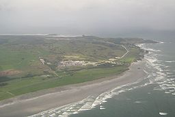
Cape Foulwind
Cape Foulwind is a prominent headland on the West Coast of New Zealand's South Island, overlooking the Tasman Sea. It is located ten kilometres west of the town of Westport...
, as well as the Holcim
Holcim
Holcim is a Swiss-based global company supplying cement and aggregates . The company also supplies ready-mix concrete and asphalt including associated construction services.-Holcim Group:...
cement plant which plays a significant part in the local economy.
See also
- New Zealand Travel Atlas, Pages 46 und 50, Wise Maps Auckland ISBN 0-908794-47-9