

New York State Route 57
Encyclopedia
New York State Route 57 (NY 57) was a major north–south state highway
in Central New York
, connecting downtown Syracuse
to the Lake Ontario
shoreline in Oswego
. The southern terminus of the route was at U.S. Route 11 in Syracuse just north of downtown and a short distance east of Lake Onondaga's southeastern tip. The northern terminus was at NY 104
(previously U.S. Route 104) six blocks from Lake Ontario in Oswego. In between, NY 57 passed through Phoenix
and Fulton
and bypassed Baldwinsville
.
North of Liverpool
, NY 57 was routed along the eastern bank of the Seneca
and Oswego River
s. The route was paralleled by NY 48
, which followed (and still follows) the western bank of the waterway between Van Buren
and Oswego.
NY 57 became part of the state highway system in 1924 as New York State Route 20. The route was renumbered to NY 57 three years later and remained virtually unchanged for the remainder of its existence. In later years, NY 57 was replaced in purpose by NY 481
south of Fulton, which led to its complete removal in 1982. The county routes that replaced NY 57 south of Fulton still bear the number 57 on signage in both counties, even though the portion of former NY 57 in Onondaga County
is officially designated as CR 91.
and adjacent to the southeastern edge of Onondaga Lake
. The route headed northwest on Park Street, passing through a large interchange on Interstate 81 before reaching a smaller interchange with Buckley Road and Old Liverpool Road. NY 57 continued northwest through the interchange, becoming Onondaga Lake Parkway and paralleling both the northeastern edge of Onondaga Lake and the now-CSX Transportation
-owned St. Lawrence Subdivision toward Liverpool
. Midway up the length of the lake, NY 57 split from the lakeshore and became Oswego Street as it entered Liverpool. Here, NY 57 met the then-eastern terminus of NY 370
and interchanged with the New York State Thruway
(Interstate 90) before leaving the Syracuse area.
Shortly after intersecting John Glenn
Boulevard, a local arterial, north of Liverpool, NY 57 took on a more pronounced northwesterly routing, matching the path of the Seneca River
a short distance to the west and the CSX Fulton Subdivision to the east. In Clay
, east of Baldwinsville
, NY 57, now primarily a residential roadway, intersected NY 31
shortly before crossing the Oneida River
and entering Oswego County
.
 Now in the town of Schroeppel
, NY 57 progressed northward in the shadow of the Oswego River
, the product of the convergence of the Seneca and Oneida Rivers. The route passed through Phoenix
, meeting the southern terminus of NY 264
, prior to intersecting NY 481
south of Fulton
. At the time, NY 481 joined NY 57 northward into Fulton on 4th and 2nd Streets before terminating at Broadway (NY 3
and NY 176
). NY 57 continued onward on 2nd Street, following the Oswego River and NY 48
, routed on the opposite bank, out of the city.
Between Fulton and Oswego
, the land surrounding NY 57 was predominantly rural in nature, with few points of interest along the alignment. North of Fulton, NY 57 passed near the Battle Island State Park
, located off of NY 48 on the west bank of the river. In Seneca Hill, across the river from Minetto
midway between the two cities, NY 57 met County Route 45, a local roadway leading to the Minetto Bridge, the only crossing of the Oswego River between Oswego and Fulton.
South of Oswego, NY 57 merged with an older alignment of the roadway and became East River Road (in contrast to NY 48, named West River Road) as it entered the city. At Albany Street, East River Road became East 1st Street, a name the route retained to its terminus at NY 104
, once U.S. Route 104, in downtown Oswego. Although NY 57 ended here, East 1st Street continued northward for a short distance to the Port of Oswego on Lake Ontario
.
to Oswego
via Fulton
on the eastern bank of the Oswego River
was originally designated as Route 34, an unsigned legislative route
, by the New York State Legislature in 1908. When the first set of posted routes in New York
were assigned in 1924, legislative Route 34 was designated as NY 20. NY 20 was redesignated as NY 57 in 1927 to eliminate numerical duplication with the newly designated U.S. Route 20. The NY 57 corridor remained unchanged until the late 1950s when construction began on a new roadway to replace the existing two-lane, curvy routing of NY 57 between Fulton and Oswego. It was completed by 1960.
 In the mid-1960s, construction began on a limited-access highway linking Fulton to Interstate 81 in North Syracuse
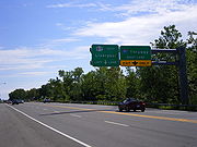
. The under-construction highway, initially known as "Relocated Route 57", was designated as NY 481
on January 1, 1970. The NY 481 designation also extended north to NY 3
in Fulton by way of a short overlap with NY 57. The expressway was completed in the early 1970s, largely replacing NY 57 as the primary roadway between Fulton and Syracuse. NY 57 and NY 481 continued to coexist until May 1982, when the NY 57 designation was eliminated. All of former NY 57 north of Fulton became part of an extended NY 481 while the portion of NY 57's former alignment east of Liverpool
became an extension of NY 370
. The short piece of former NY 57 in Liverpool between Tulip Street and NY 370 became NY 931G, an unsigned reference route.
The remainder of former NY 57 between Tulip Street in Liverpool and NY 481 south of Fulton was turned over to Oswego
and Onondaga
Counties and became county routes. In Oswego County, the old alignment of NY 57 south of Fulton became the signed County Route 57 (CR 57). In Onondaga County, the former routing of NY 57 was designated as CR 91; however, it is signed as CR 57 in homage to the state route that preceded it. Many reference markers
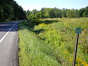
for NY 57 are still intact along its former routing from Liverpool to Fulton. CR 57 continues to serve as a major thoroughfare today, serving the various rural communities on the route.
State highway
State highway, state road or state route can refer to one of three related concepts, two of them related to a state or provincial government in a country that is divided into states or provinces :#A...
in Central New York
Central New York
Central New York is a term used to broadly describe the central region of New York State, roughly including the following counties and cities:...
, connecting downtown Syracuse
Syracuse, New York
Syracuse is a city in and the county seat of Onondaga County, New York, United States, the largest U.S. city with the name "Syracuse", and the fifth most populous city in the state. At the 2010 census, the city population was 145,170, and its metropolitan area had a population of 742,603...
to the Lake Ontario
Lake Ontario
Lake Ontario is one of the five Great Lakes of North America. It is bounded on the north and southwest by the Canadian province of Ontario, and on the south by the American state of New York. Ontario, Canada's most populous province, was named for the lake. In the Wyandot language, ontarío means...
shoreline in Oswego
Oswego, New York
Oswego is a city in Oswego County, New York, United States. The population was 18,142 at the 2010 census. Oswego is located on Lake Ontario in north-central New York and promotes itself as "The Port City of Central New York"...
. The southern terminus of the route was at U.S. Route 11 in Syracuse just north of downtown and a short distance east of Lake Onondaga's southeastern tip. The northern terminus was at NY 104
New York State Route 104
New York State Route 104 is a long east–west state highway in Upstate New York, United States. It spans six counties and enters the vicinity of four cities—Niagara Falls, Lockport, Rochester, and Oswego—as it follows a routing largely parallel to that of the southern shoreline of Lake...
(previously U.S. Route 104) six blocks from Lake Ontario in Oswego. In between, NY 57 passed through Phoenix
Phoenix, New York
Phoenix is a village in Oswego County, New York, United States, about north of Syracuse. The population was 2,251 at the 2000 census. The name is derived from Alexander Phoenix...
and Fulton
Fulton, Oswego County, New York
Fulton is a small city in Oswego County, New York, United States. The population was 11,855 at the 2000 census. The city is named after Robert Fulton, inventor of the steamboat.The city of Fulton is located in the western part of the county....
and bypassed Baldwinsville
Baldwinsville, New York
Baldwinsville is a village in Onondaga County, New York, United States. The population was 7,053 at the 2000 census. It is part of the Syracuse Metropolitan Statistical Area....
.
North of Liverpool
Liverpool, New York
Liverpool is a village located in Onondaga County, New York, United States. The population was 2,505 at the 2000 census. The name was adopted from the city of Liverpool in the United Kingdom...
, NY 57 was routed along the eastern bank of the Seneca
Seneca River (New York)
The Seneca River in central New York flows from west to east, from Seneca Lake, through the Montezuma Marsh at the north end of Cayuga Lake to the Seneca's confluence with the Oneida and Oswego rivers at the Three Rivers area north of Syracuse. Much of the river has been channelized to form part...
and Oswego River
Oswego River (New York)
The Oswego River is a river in upstate New York in the United States. This river is the second-largest river flowing into Lake Ontario. James Fenimore Cooper’s novel The Pathfinder, or The Inland Sea is set in the Oswego River valley...
s. The route was paralleled by NY 48
New York State Route 48
New York State Route 48 is a north–south state highway in Central New York in the United States. The southern terminus of the route is located at Interstate 690 exit 3 near the interchange between I-690 and the New York State Thruway in Van Buren, northwest of Syracuse...
, which followed (and still follows) the western bank of the waterway between Van Buren
Van Buren, New York
Van Buren is a town located in Onondaga County, New York, United States. As of the 2000 census, the town had a population of 12,667. The town is named after future President Martin van Buren, who was then governor of the state....
and Oswego.
NY 57 became part of the state highway system in 1924 as New York State Route 20. The route was renumbered to NY 57 three years later and remained virtually unchanged for the remainder of its existence. In later years, NY 57 was replaced in purpose by NY 481
New York State Route 481
New York State Route 481 is a state highway in Central New York in the United States. The southern terminus of the route is at an interchange with Interstate 81 in North Syracuse, where the highway continues southeastward as I-481. Its northern terminus is located at an intersection...
south of Fulton, which led to its complete removal in 1982. The county routes that replaced NY 57 south of Fulton still bear the number 57 on signage in both counties, even though the portion of former NY 57 in Onondaga County
Onondaga County, New York
Onondaga County is a county located in the U.S. state of New York. As of the 2010 census, the population was 467,026. The county seat is Syracuse.Onondaga County is part of the Syracuse, NY Metropolitan Statistical Area....
is officially designated as CR 91.
Route description
NY 57 began at the intersection of Park Street and Wolf Street (U.S. Route 11) north of downtown SyracuseSyracuse, New York
Syracuse is a city in and the county seat of Onondaga County, New York, United States, the largest U.S. city with the name "Syracuse", and the fifth most populous city in the state. At the 2010 census, the city population was 145,170, and its metropolitan area had a population of 742,603...
and adjacent to the southeastern edge of Onondaga Lake
Onondaga Lake
Onondaga Lake is a lake in Central New York located northwest of Syracuse, New York. The southeastern end of the lake and the southwestern shore abut industrial areas and expressways; the northeastern shore and northwestern end border a series of parks and museums. Although it is near the Finger...
. The route headed northwest on Park Street, passing through a large interchange on Interstate 81 before reaching a smaller interchange with Buckley Road and Old Liverpool Road. NY 57 continued northwest through the interchange, becoming Onondaga Lake Parkway and paralleling both the northeastern edge of Onondaga Lake and the now-CSX Transportation
CSX Transportation
CSX Transportation operates a Class I railroad in the United States known as the CSX Railroad. It is the main subsidiary of the CSX Corporation. The company is headquartered in Jacksonville, Florida, and owns approximately 21,000 route miles...
-owned St. Lawrence Subdivision toward Liverpool
Liverpool, New York
Liverpool is a village located in Onondaga County, New York, United States. The population was 2,505 at the 2000 census. The name was adopted from the city of Liverpool in the United Kingdom...
. Midway up the length of the lake, NY 57 split from the lakeshore and became Oswego Street as it entered Liverpool. Here, NY 57 met the then-eastern terminus of NY 370
New York State Route 370
New York State Route 370 is an east–west state highway in central New York in the United States. It extends for from an intersection with NY 104 and NY 104A south of the Wayne County village of Red Creek to a junction with U.S. Route 11 in the Onondaga County city of Syracuse...
and interchanged with the New York State Thruway
New York State Thruway
The New York State Thruway is a system of limited-access highways located within the state of New York in the United States. The system, known officially as the Governor Thomas E. Dewey Thruway for former New York Governor Thomas E. Dewey, is operated by the New York State Thruway Authority and...
(Interstate 90) before leaving the Syracuse area.
Shortly after intersecting John Glenn
John Glenn
John Herschel Glenn, Jr. is a former United States Marine Corps pilot, astronaut, and United States senator who was the first American to orbit the Earth and the third American in space. Glenn was a Marine Corps fighter pilot before joining NASA's Mercury program as a member of NASA's original...
Boulevard, a local arterial, north of Liverpool, NY 57 took on a more pronounced northwesterly routing, matching the path of the Seneca River
Seneca River (New York)
The Seneca River in central New York flows from west to east, from Seneca Lake, through the Montezuma Marsh at the north end of Cayuga Lake to the Seneca's confluence with the Oneida and Oswego rivers at the Three Rivers area north of Syracuse. Much of the river has been channelized to form part...
a short distance to the west and the CSX Fulton Subdivision to the east. In Clay
Clay, New York
Clay is a town in Onondaga County, New York, USA. As of the 2000 census, the town had a total population of 58,805, making it Syracuse's largest suburb. The town was named after Henry Clay, statesman....
, east of Baldwinsville
Baldwinsville, New York
Baldwinsville is a village in Onondaga County, New York, United States. The population was 7,053 at the 2000 census. It is part of the Syracuse Metropolitan Statistical Area....
, NY 57, now primarily a residential roadway, intersected NY 31
New York State Route 31
New York State Route 31 is a state highway that extends for across western and central New York in the United States. The western terminus of the route is at an intersection with NY 104 in the city of Niagara Falls. Its eastern terminus is at a traffic circle with NY 26 in Vernon...
shortly before crossing the Oneida River
Oneida River
The Oneida River in central New York state flows from Oneida Lake to its confluence with the Seneca and Oswego rivers. The Oswego empties the water of the other two rivers into Lake Ontario....
and entering Oswego County
Oswego County, New York
Oswego County is a county located in the U.S. state of New York. As of the 2010 Census, the estimated population was 122,109. The City of Oswego and the Village of Pulaski serve as the dual county seats in a two shire system of government...
.
Schroeppel, New York
Schroeppel is a town in Oswego County, New York, United States. The population was 8,566 at the 2000 census. The name derives from the Schroeppel family, early land owners of the area.The Town of Schroeppel is in the southeast part of the county....
, NY 57 progressed northward in the shadow of the Oswego River
Oswego River (New York)
The Oswego River is a river in upstate New York in the United States. This river is the second-largest river flowing into Lake Ontario. James Fenimore Cooper’s novel The Pathfinder, or The Inland Sea is set in the Oswego River valley...
, the product of the convergence of the Seneca and Oneida Rivers. The route passed through Phoenix
Phoenix, New York
Phoenix is a village in Oswego County, New York, United States, about north of Syracuse. The population was 2,251 at the 2000 census. The name is derived from Alexander Phoenix...
, meeting the southern terminus of NY 264
New York State Route 264
New York State Route 264 is a north–south state highway in Oswego County, New York, United States. It runs from an intersection with County Route 57 in the village of Phoenix north to a junction with NY 3 in the town of Palermo...
, prior to intersecting NY 481
New York State Route 481
New York State Route 481 is a state highway in Central New York in the United States. The southern terminus of the route is at an interchange with Interstate 81 in North Syracuse, where the highway continues southeastward as I-481. Its northern terminus is located at an intersection...
south of Fulton
Fulton, Oswego County, New York
Fulton is a small city in Oswego County, New York, United States. The population was 11,855 at the 2000 census. The city is named after Robert Fulton, inventor of the steamboat.The city of Fulton is located in the western part of the county....
. At the time, NY 481 joined NY 57 northward into Fulton on 4th and 2nd Streets before terminating at Broadway (NY 3
New York State Route 3
New York State Route 3 is a major east–west state highway in New York, United States, that connects central New York to the North Country region near the Canadian border via Adirondack Park. The route extends for between its western terminus at an intersection with NY 104A in the Cayuga...
and NY 176
New York State Route 176
New York State Route 176 is a north–south state highway located in the central part of New York, United States, that connects Cayuga County with Oswego County. The southern terminus of the route is at an intersection with NY 370 in the northeast part of the town of Cato, east of...
). NY 57 continued onward on 2nd Street, following the Oswego River and NY 48
New York State Route 48
New York State Route 48 is a north–south state highway in Central New York in the United States. The southern terminus of the route is located at Interstate 690 exit 3 near the interchange between I-690 and the New York State Thruway in Van Buren, northwest of Syracuse...
, routed on the opposite bank, out of the city.
Between Fulton and Oswego
Oswego, New York
Oswego is a city in Oswego County, New York, United States. The population was 18,142 at the 2010 census. Oswego is located on Lake Ontario in north-central New York and promotes itself as "The Port City of Central New York"...
, the land surrounding NY 57 was predominantly rural in nature, with few points of interest along the alignment. North of Fulton, NY 57 passed near the Battle Island State Park
Battle Island State Park
Battle Island State Park is a state park located on the Oswego River in Oswego County, New York. It got its name from a battle that took place on a nearby island in the mid 18th century...
, located off of NY 48 on the west bank of the river. In Seneca Hill, across the river from Minetto
Minetto (CDP), New York
Minetto is a hamlet in Oswego County, New York, USA. The population was 1,086 at the 2000 census.Minetto is located in the Town of Minetto at the south city line of Oswego, New York...
midway between the two cities, NY 57 met County Route 45, a local roadway leading to the Minetto Bridge, the only crossing of the Oswego River between Oswego and Fulton.
South of Oswego, NY 57 merged with an older alignment of the roadway and became East River Road (in contrast to NY 48, named West River Road) as it entered the city. At Albany Street, East River Road became East 1st Street, a name the route retained to its terminus at NY 104
New York State Route 104
New York State Route 104 is a long east–west state highway in Upstate New York, United States. It spans six counties and enters the vicinity of four cities—Niagara Falls, Lockport, Rochester, and Oswego—as it follows a routing largely parallel to that of the southern shoreline of Lake...
, once U.S. Route 104, in downtown Oswego. Although NY 57 ended here, East 1st Street continued northward for a short distance to the Port of Oswego on Lake Ontario
Lake Ontario
Lake Ontario is one of the five Great Lakes of North America. It is bounded on the north and southwest by the Canadian province of Ontario, and on the south by the American state of New York. Ontario, Canada's most populous province, was named for the lake. In the Wyandot language, ontarío means...
.
History
The primary north–south roadway connecting SyracuseSyracuse, New York
Syracuse is a city in and the county seat of Onondaga County, New York, United States, the largest U.S. city with the name "Syracuse", and the fifth most populous city in the state. At the 2010 census, the city population was 145,170, and its metropolitan area had a population of 742,603...
to Oswego
Oswego, New York
Oswego is a city in Oswego County, New York, United States. The population was 18,142 at the 2010 census. Oswego is located on Lake Ontario in north-central New York and promotes itself as "The Port City of Central New York"...
via Fulton
Fulton, Oswego County, New York
Fulton is a small city in Oswego County, New York, United States. The population was 11,855 at the 2000 census. The city is named after Robert Fulton, inventor of the steamboat.The city of Fulton is located in the western part of the county....
on the eastern bank of the Oswego River
Oswego River (New York)
The Oswego River is a river in upstate New York in the United States. This river is the second-largest river flowing into Lake Ontario. James Fenimore Cooper’s novel The Pathfinder, or The Inland Sea is set in the Oswego River valley...
was originally designated as Route 34, an unsigned legislative route
Legislative route
In United States, a legislative route or legislative highway is a highway defined by laws passed in a state legislature. The numbering of such highways may or may not correspond to the numbers familiar to the public as part of the state, U.S. highway, and Interstate highway systems...
, by the New York State Legislature in 1908. When the first set of posted routes in New York
New York
New York is a state in the Northeastern region of the United States. It is the nation's third most populous state. New York is bordered by New Jersey and Pennsylvania to the south, and by Connecticut, Massachusetts and Vermont to the east...
were assigned in 1924, legislative Route 34 was designated as NY 20. NY 20 was redesignated as NY 57 in 1927 to eliminate numerical duplication with the newly designated U.S. Route 20. The NY 57 corridor remained unchanged until the late 1950s when construction began on a new roadway to replace the existing two-lane, curvy routing of NY 57 between Fulton and Oswego. It was completed by 1960.
North Syracuse, New York
North Syracuse is a village in Onondaga County, New York, United States. The population was 6,863 at the 2000 census.The Village of North Syracuse is partly in the Town of Cicero, but is primarily within the Town of Clay. North Syracuse is north of the City of Syracuse.- History :The village was...
. The under-construction highway, initially known as "Relocated Route 57", was designated as NY 481
New York State Route 481
New York State Route 481 is a state highway in Central New York in the United States. The southern terminus of the route is at an interchange with Interstate 81 in North Syracuse, where the highway continues southeastward as I-481. Its northern terminus is located at an intersection...
on January 1, 1970. The NY 481 designation also extended north to NY 3
New York State Route 3
New York State Route 3 is a major east–west state highway in New York, United States, that connects central New York to the North Country region near the Canadian border via Adirondack Park. The route extends for between its western terminus at an intersection with NY 104A in the Cayuga...
in Fulton by way of a short overlap with NY 57. The expressway was completed in the early 1970s, largely replacing NY 57 as the primary roadway between Fulton and Syracuse. NY 57 and NY 481 continued to coexist until May 1982, when the NY 57 designation was eliminated. All of former NY 57 north of Fulton became part of an extended NY 481 while the portion of NY 57's former alignment east of Liverpool
Liverpool, New York
Liverpool is a village located in Onondaga County, New York, United States. The population was 2,505 at the 2000 census. The name was adopted from the city of Liverpool in the United Kingdom...
became an extension of NY 370
New York State Route 370
New York State Route 370 is an east–west state highway in central New York in the United States. It extends for from an intersection with NY 104 and NY 104A south of the Wayne County village of Red Creek to a junction with U.S. Route 11 in the Onondaga County city of Syracuse...
. The short piece of former NY 57 in Liverpool between Tulip Street and NY 370 became NY 931G, an unsigned reference route.
The remainder of former NY 57 between Tulip Street in Liverpool and NY 481 south of Fulton was turned over to Oswego
Oswego County, New York
Oswego County is a county located in the U.S. state of New York. As of the 2010 Census, the estimated population was 122,109. The City of Oswego and the Village of Pulaski serve as the dual county seats in a two shire system of government...
and Onondaga
Onondaga County, New York
Onondaga County is a county located in the U.S. state of New York. As of the 2010 census, the population was 467,026. The county seat is Syracuse.Onondaga County is part of the Syracuse, NY Metropolitan Statistical Area....
Counties and became county routes. In Oswego County, the old alignment of NY 57 south of Fulton became the signed County Route 57 (CR 57). In Onondaga County, the former routing of NY 57 was designated as CR 91; however, it is signed as CR 57 in homage to the state route that preceded it. Many reference markers
Reference marker (New York)
In New York, a reference marker is a small green sign mounted approximately every one-tenth mile on highways maintained by the New York State Department of Transportation. This was initiated in response to the Highway Safety Act of 1966 enacted by Congress, in an effort to monitor traffic and...
for NY 57 are still intact along its former routing from Liverpool to Fulton. CR 57 continues to serve as a major thoroughfare today, serving the various rural communities on the route.