
New York State Route 428
Encyclopedia
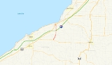
New York State Route 428 (NY 428) was a north–south state highway
located within Chautauqua County
, New York
, United States
. The southern terminus of the route was at an intersection with NY 39
in Forestville
. Its northern terminus was at a junction with U.S. Route 20 (US 20) in Silver Creek
. The route passed through mostly rural areas and crossed over the New York State Thruway
(Interstate 90 or I-90) without connecting to the highway.
NY 428 was assigned ca. 1932 and removed in 1980 after ownership and maintenance of the highway was transferred from the state of New York to Chautauqua County as part of a highway maintenance swap between the two levels of government. Although the swap took effect on April 1, the NY 428 designation was not removed until September 9. The former routing of NY 428 is now the northernmost section of County Route 85.
and County Route 87 (CR 87) in Forestville
. It headed north through the village on Center Street, passing by several blocks of homes and intersecting CR 89 before it exited Forestville. Outside of Forestville in Hanover
, NY 428 continued northward as Bennett-State Road through farmland, paralleling both CR 89 and Walnut Creek to the hamlet of Keaches Corners, where it met CR 84.
The highway continued onward through open fields, intersecting CR 86 just before passing over the New York State Thruway
(I-90). Past the Thruway, NY 428 continued north along Silver Creek into the village of Silver Creek
, where it became known as Division Street at the village line. It followed Division Street for two blocks through a lightly populated area before turning west onto Burgess Street for another two blocks through a more densely populated portion of the community. NY 428 ended at an intersection with US 20 south of the village center.
and Silver Creek
. The route remained intact until 1980 when the roadway was given to Chautauqua County
as part of a large-scale maintenance swap of routes within the county. Under the terms of the deal, NY 428 was transferred to the county along with NY 424
, the segment of NY 380 between NY 424 and US 20, and two reference routes in the vicinity of Dunkirk and Fredonia
. In exchange, NYSDOT assumed control over NY 394
between US 20 and NY 5
in Westfield
, US 62 from NY 60
to NY 394 east of Jamestown
, and Forest Avenue (unsigned reference route NY 952P) from the Pennsylvania state line in Busti
to NY 60 in Jamestown. Although the swap was officially conducted on April 1, NY 428 was not removed until September 9. CR 85, which ran from CR 66 in Thornton to NY 39 in Forestville at the time, was then extended northward over the former routing of NY 428 to Silver Creek.
State highway
State highway, state road or state route can refer to one of three related concepts, two of them related to a state or provincial government in a country that is divided into states or provinces :#A...
located within Chautauqua County
Chautauqua County, New York
-Major highways:* Interstate 86/New York State Route 17 * Interstate 90 * U.S. Route 20* U.S. Route 62* New York State Route 5* New York State Route 39* New York State Route 60* New York State Route 394...
, New York
New York
New York is a state in the Northeastern region of the United States. It is the nation's third most populous state. New York is bordered by New Jersey and Pennsylvania to the south, and by Connecticut, Massachusetts and Vermont to the east...
, United States
United States
The United States of America is a federal constitutional republic comprising fifty states and a federal district...
. The southern terminus of the route was at an intersection with NY 39
New York State Route 39
New York State Route 39 is an east–west state highway in the western portion of New York in the United States. It begins and ends at intersections with U.S. Route 20 apart...
in Forestville
Forestville, New York
Forestville is a village in Chautauqua County, New York, United States. The population was 770 at the 2000 census.The Village of Forestville is within the Town of Hanover and in the northeast part of the county....
. Its northern terminus was at a junction with U.S. Route 20 (US 20) in Silver Creek
Silver Creek, New York
- Demographics :At the 2010 census there were 2,656 people, 1,048 households and 718 families residing in the village. The population density was 2,213.3 people per square mile . There were 1,174 housing units, with an average density of 978.3 per square mile...
. The route passed through mostly rural areas and crossed over the New York State Thruway
New York State Thruway
The New York State Thruway is a system of limited-access highways located within the state of New York in the United States. The system, known officially as the Governor Thomas E. Dewey Thruway for former New York Governor Thomas E. Dewey, is operated by the New York State Thruway Authority and...
(Interstate 90 or I-90) without connecting to the highway.
NY 428 was assigned ca. 1932 and removed in 1980 after ownership and maintenance of the highway was transferred from the state of New York to Chautauqua County as part of a highway maintenance swap between the two levels of government. Although the swap took effect on April 1, the NY 428 designation was not removed until September 9. The former routing of NY 428 is now the northernmost section of County Route 85.
Route description
NY 428 began at an intersection with NY 39New York State Route 39
New York State Route 39 is an east–west state highway in the western portion of New York in the United States. It begins and ends at intersections with U.S. Route 20 apart...
and County Route 87 (CR 87) in Forestville
Forestville, New York
Forestville is a village in Chautauqua County, New York, United States. The population was 770 at the 2000 census.The Village of Forestville is within the Town of Hanover and in the northeast part of the county....
. It headed north through the village on Center Street, passing by several blocks of homes and intersecting CR 89 before it exited Forestville. Outside of Forestville in Hanover
Hanover, New York
Hanover is a town in Chautauqua County, New York, United States. The population was 7,638 at the 2000 census.The Town of Hanover lies in the northeast corner of Chautauqua County.- History :The first settler arrived in 1796....
, NY 428 continued northward as Bennett-State Road through farmland, paralleling both CR 89 and Walnut Creek to the hamlet of Keaches Corners, where it met CR 84.
The highway continued onward through open fields, intersecting CR 86 just before passing over the New York State Thruway
New York State Thruway
The New York State Thruway is a system of limited-access highways located within the state of New York in the United States. The system, known officially as the Governor Thomas E. Dewey Thruway for former New York Governor Thomas E. Dewey, is operated by the New York State Thruway Authority and...
(I-90). Past the Thruway, NY 428 continued north along Silver Creek into the village of Silver Creek
Silver Creek, New York
- Demographics :At the 2010 census there were 2,656 people, 1,048 households and 718 families residing in the village. The population density was 2,213.3 people per square mile . There were 1,174 housing units, with an average density of 978.3 per square mile...
, where it became known as Division Street at the village line. It followed Division Street for two blocks through a lightly populated area before turning west onto Burgess Street for another two blocks through a more densely populated portion of the community. NY 428 ended at an intersection with US 20 south of the village center.
History
NY 428 was assigned ca. 1932 to a previously unnumbered roadway between ForestvilleForestville, New York
Forestville is a village in Chautauqua County, New York, United States. The population was 770 at the 2000 census.The Village of Forestville is within the Town of Hanover and in the northeast part of the county....
and Silver Creek
Silver Creek, New York
- Demographics :At the 2010 census there were 2,656 people, 1,048 households and 718 families residing in the village. The population density was 2,213.3 people per square mile . There were 1,174 housing units, with an average density of 978.3 per square mile...
. The route remained intact until 1980 when the roadway was given to Chautauqua County
Chautauqua County, New York
-Major highways:* Interstate 86/New York State Route 17 * Interstate 90 * U.S. Route 20* U.S. Route 62* New York State Route 5* New York State Route 39* New York State Route 60* New York State Route 394...
as part of a large-scale maintenance swap of routes within the county. Under the terms of the deal, NY 428 was transferred to the county along with NY 424
New York State Route 424
New York State Route 424 was an east–west state highway in northern Chautauqua County, New York, United States. The route began at an intersection with NY 380 in the town of Stockton and ended at a junction with NY 60 in the village of Cassadaga...
, the segment of NY 380 between NY 424 and US 20, and two reference routes in the vicinity of Dunkirk and Fredonia
Fredonia, New York
Fredonia is a village in Chautauqua County, New York, United States. The population was 11,068 as of 2009.The Village of Fredonia is in the Town of Pomfret south of Lake Erie...
. In exchange, NYSDOT assumed control over NY 394
New York State Route 394
New York State Route 394 is a state highway located within Cattaraugus and Chautauqua Counties in southwestern New York, United States. Its western terminus is located on the shore of Lake Erie at an intersection with NY 5 in the Westfield hamlet of Barcelona...
between US 20 and NY 5
New York State Route 5
New York State Route 5 is a state highway that extends for across the state of New York in the United States. It begins at the Pennsylvania state line in the Chautauqua County town of Ripley and passes through Buffalo, Syracuse, Utica, Schenectady, and several other smaller cities and...
in Westfield
Westfield (town), New York
Westfield is a town in the western part Chautauqua County, New York, United States. The population was 5,232 at the 2000 census. Westfield is also the name of a village within the town.- History :...
, US 62 from NY 60
New York State Route 60
New York State Route 60 is a north–south state highway in Chautauqua County, New York, United States. The southern terminus of the route is at an intersection with U.S. Route 62 south of the city of Jamestown in the town of Kiantone. Its northern terminus is at a junction with NY 5...
to NY 394 east of Jamestown
Jamestown, New York
Jamestown is a city in Chautauqua County, New York in the United States. The population was 31,146 at the 2010 census.The City of Jamestown is adjacent to Town of Ellicott and is at the southern tip of Chautauqua Lake...
, and Forest Avenue (unsigned reference route NY 952P) from the Pennsylvania state line in Busti
Busti, New York
Busti is a town in Chautauqua County, New York, United States. The population was 7,760 at the 2000 census. The town is named after Paul Busti, an official of the Holland Land Company, but its pronunciation uses a long i sound at the end, a frequent alteration in the names of several upstate New...
to NY 60 in Jamestown. Although the swap was officially conducted on April 1, NY 428 was not removed until September 9. CR 85, which ran from CR 66 in Thornton to NY 39 in Forestville at the time, was then extended northward over the former routing of NY 428 to Silver Creek.