
New York State Route 32B
Encyclopedia
New York State Route 32B (NY 32B) was a state highway
in the Capital District
region of New York
, United States
. The western terminus of the route was at an intersection with NY 32
in Queensbury
. Its eastern terminus was at a junction with U.S. Route 4
(US 4) in Hudson Falls
. NY 32B, named Warren Street in Queensbury and River Street in Hudson Falls, ran along the banks of the Hudson River
as it went from Glens Falls
to Hudson Falls. It crossed over the Glens Falls Feeder Canal
near its junction with NY 32 in Queensbury.
When NY 32B was assigned as part of the 1930 renumbering of state highways in New York, it began at an intersection with US 4 and NY 32 in Northumberland
and ended at US 9 in Glens Falls
. The portion of the route between Northumberland and Hudson Falls
was concurrent
with US 4 upon assignment while the segment west of Boulevard in Queensbury later became concurrent with NY 32. It was truncated north to Hudson Falls in the early 1940s and east to Boulevard ca. 1962. NY 32B was partially replaced with NY 254
ca. 1965.
 NY 32B, as routed at the time of its removal, began at the intersection of Boulevard (then-NY 32
), Warren Street (NY 32 west of Boulevard), and Highland Avenue east of Glens Falls
in the Warren County
town of Queensbury
. The route headed east along Warren Street (here named Lower Warren Street), paralleling the eastern bank of the Hudson River
. It crossed over the Glens Falls Feeder Canal
prior to reaching the Warren–Washington
county line. Here, Warren Street turns north to straddle the county line; however, NY 32B continued southeastward into Hudson Falls
on River Street. NY 32B ended five blocks later at a junction with US 4
in downtown Hudson Falls.
and River Street in Hudson Falls
became part of NY 30, a highway that initially extended from Mechanicville
to the Vermont
state line near Fair Haven by way of Glens Falls and Whitehall
. It was realigned by 1926 to continue north from Whitehall toward the Canadian border. In 1926, the portion of NY 30 between Glens Falls and Whitehall was included in the new US 4, which began in Glens Falls and continued east from Whitehall into Vermont by way of NY 30's former routing. It was rerouted to follow its modern alignment south of Hudson Falls as part of the 1930 renumbering of state highways in New York. US 4's former routing between Glens Falls and Hudson Falls became part of NY 32B, a new route assigned in the renumbering that continued south to NY 32
in Northumberland
by way of an overlap with US 4.
NY 32B was gradually truncated as time went on. In the early 1940s, NY 32B was cut back on its east end to its junction with US 4 in Hudson Falls, eliminating its lengthy overlap with US 4 along the Hudson River
. However, it remained connected to NY 32 as that route was extended northeastward from South Glens Falls
to Hudson Falls along Warren Street, Boulevard, and Feeder Street by 1940. The resulting overlap between NY 32 and NY 32B along Warren Street from US 9 in downtown Glens Falls to Boulevard remained in place until ca. 1962 when NY 32B was truncated on its western end to the eastern terminus of the overlap.
 NY 32B ceased to exist altogether ca. 1965 when the portion of NY 32B east of the newly-constructed Quaker Road was incorporated into the new NY 254
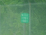
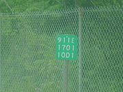
. The segment of former NY 32B that did not become part of NY 254—located on Lower Warren Street in Queensbury
—is now NY 911E, an unsigned reference route 0.2 mile (0.321868 km) in length. It is one of three reference routes in Warren County
. The NY 656 designation is reserved by the New York State Department of Transportation
as a signed replacement for NY 911E; however, there is no timetable for its assignment.
State highway
State highway, state road or state route can refer to one of three related concepts, two of them related to a state or provincial government in a country that is divided into states or provinces :#A...
in the Capital District
Capital District
New York's Capital District, also known as the Capital Region, is a region in upstate New York that generally refers to the four counties surrounding Albany, the capital of the state: Albany County, Schenectady County, Rensselaer County, and Saratoga County...
region of New York
New York
New York is a state in the Northeastern region of the United States. It is the nation's third most populous state. New York is bordered by New Jersey and Pennsylvania to the south, and by Connecticut, Massachusetts and Vermont to the east...
, United States
United States
The United States of America is a federal constitutional republic comprising fifty states and a federal district...
. The western terminus of the route was at an intersection with NY 32
New York State Route 32
New York State Route 32 is a north–south state highway that extends for through the Hudson Valley and Capital District regions of the U.S. state of New York. It is a two-lane surface road for nearly its entire length, with few divided and no limited-access sections. From Harriman to Albany,...
in Queensbury
Queensbury, New York
Queensbury is a town in and the county seat of Warren County, New York, United States. The town is located in the southeastern part of the county. The population was 25,441 at the 2000 census. The town is named in honor of Queen Charlotte, the consort of George III of Great Britain and Ireland. It...
. Its eastern terminus was at a junction with U.S. Route 4
U.S. Route 4 in New York
U.S. Route 4 is a part of the U.S. Highway System that runs from East Greenbush, New York, to Portsmouth, New Hampshire. In the U.S. state of New York, US 4 extends from an intersection with US 9 and US 20 in East Greenbush to the Vermont state line northeast of Whitehall...
(US 4) in Hudson Falls
Hudson Falls, New York
Hudson Falls is a village located in Washington County, New York, USA. The village is in the southwest part of the town of Kingsbury, on US Route 4. Hudson Falls is part of the Glens Falls Metropolitan Statistical Area. As of the 2000 census, the village had a population of 6,927...
. NY 32B, named Warren Street in Queensbury and River Street in Hudson Falls, ran along the banks of the Hudson River
Hudson River
The Hudson is a river that flows from north to south through eastern New York. The highest official source is at Lake Tear of the Clouds, on the slopes of Mount Marcy in the Adirondack Mountains. The river itself officially begins in Henderson Lake in Newcomb, New York...
as it went from Glens Falls
Glens Falls, New York
Glens Falls is a city in Warren County, New York, United States. Glens Falls Metropolitan Statistical Area. The population was 14,700 at the 2010 census...
to Hudson Falls. It crossed over the Glens Falls Feeder Canal
Glens Falls Feeder Canal
The Glens Falls Feeder Canal is a canal from Glens Falls, New York, United States through Hudson Falls and into Fort Edward. It is seven miles long and delivers water from above Glen's Falls on the Hudson River to the highest point of the Champlain Canal...
near its junction with NY 32 in Queensbury.
When NY 32B was assigned as part of the 1930 renumbering of state highways in New York, it began at an intersection with US 4 and NY 32 in Northumberland
Northumberland, New York
Northumberland is a town in Saratoga County, New York, United States. The population was 4,603 at the 2000 census. The name comes from a location in Great Britain....
and ended at US 9 in Glens Falls
Glens Falls, New York
Glens Falls is a city in Warren County, New York, United States. Glens Falls Metropolitan Statistical Area. The population was 14,700 at the 2010 census...
. The portion of the route between Northumberland and Hudson Falls
Hudson Falls, New York
Hudson Falls is a village located in Washington County, New York, USA. The village is in the southwest part of the town of Kingsbury, on US Route 4. Hudson Falls is part of the Glens Falls Metropolitan Statistical Area. As of the 2000 census, the village had a population of 6,927...
was concurrent
Concurrency (road)
A concurrency, overlap, or coincidence in a road network is an instance of one physical road bearing two or more different highway, motorway, or other route numbers...
with US 4 upon assignment while the segment west of Boulevard in Queensbury later became concurrent with NY 32. It was truncated north to Hudson Falls in the early 1940s and east to Boulevard ca. 1962. NY 32B was partially replaced with NY 254
New York State Route 254
New York State Route 254 is a state highway that extends for through Warren and Washington Counties in the Capital District of New York, United States...
ca. 1965.
Route description
New York State Route 32
New York State Route 32 is a north–south state highway that extends for through the Hudson Valley and Capital District regions of the U.S. state of New York. It is a two-lane surface road for nearly its entire length, with few divided and no limited-access sections. From Harriman to Albany,...
), Warren Street (NY 32 west of Boulevard), and Highland Avenue east of Glens Falls
Glens Falls, New York
Glens Falls is a city in Warren County, New York, United States. Glens Falls Metropolitan Statistical Area. The population was 14,700 at the 2010 census...
in the Warren County
Warren County, New York
Warren County is a county in the U.S. state of New York. It is part of the Glens Falls, New York, Metropolitan Statistical Area. As of the 2010 census, the population was 65,707. It is named in honor of General Joseph Warren, an American Revolutionary War hero of the Battle of Bunker Hill...
town of Queensbury
Queensbury, New York
Queensbury is a town in and the county seat of Warren County, New York, United States. The town is located in the southeastern part of the county. The population was 25,441 at the 2000 census. The town is named in honor of Queen Charlotte, the consort of George III of Great Britain and Ireland. It...
. The route headed east along Warren Street (here named Lower Warren Street), paralleling the eastern bank of the Hudson River
Hudson River
The Hudson is a river that flows from north to south through eastern New York. The highest official source is at Lake Tear of the Clouds, on the slopes of Mount Marcy in the Adirondack Mountains. The river itself officially begins in Henderson Lake in Newcomb, New York...
. It crossed over the Glens Falls Feeder Canal
Glens Falls Feeder Canal
The Glens Falls Feeder Canal is a canal from Glens Falls, New York, United States through Hudson Falls and into Fort Edward. It is seven miles long and delivers water from above Glen's Falls on the Hudson River to the highest point of the Champlain Canal...
prior to reaching the Warren–Washington
Washington County, New York
Washington County is a county located in the U.S. state of New York. It is part of the Glens Falls, New York, Metropolitan Statistical Area. As of the 2010 census, the population was 63,216. It was named for the Revolutionary War general George Washington...
county line. Here, Warren Street turns north to straddle the county line; however, NY 32B continued southeastward into Hudson Falls
Hudson Falls, New York
Hudson Falls is a village located in Washington County, New York, USA. The village is in the southwest part of the town of Kingsbury, on US Route 4. Hudson Falls is part of the Glens Falls Metropolitan Statistical Area. As of the 2000 census, the village had a population of 6,927...
on River Street. NY 32B ended five blocks later at a junction with US 4
U.S. Route 4 in New York
U.S. Route 4 is a part of the U.S. Highway System that runs from East Greenbush, New York, to Portsmouth, New Hampshire. In the U.S. state of New York, US 4 extends from an intersection with US 9 and US 20 in East Greenbush to the Vermont state line northeast of Whitehall...
in downtown Hudson Falls.
History
In 1924, Warren Street in Glens FallsGlens Falls, New York
Glens Falls is a city in Warren County, New York, United States. Glens Falls Metropolitan Statistical Area. The population was 14,700 at the 2010 census...
and River Street in Hudson Falls
Hudson Falls, New York
Hudson Falls is a village located in Washington County, New York, USA. The village is in the southwest part of the town of Kingsbury, on US Route 4. Hudson Falls is part of the Glens Falls Metropolitan Statistical Area. As of the 2000 census, the village had a population of 6,927...
became part of NY 30, a highway that initially extended from Mechanicville
Mechanicville, New York
Mechanicville is a city in Saratoga County, New York, United States. The population is 5,196 as of the 2010 census. It is the smallest city by area in the state. The name is derived from the occupations of early residents....
to the Vermont
Vermont
Vermont is a state in the New England region of the northeastern United States of America. The state ranks 43rd in land area, , and 45th in total area. Its population according to the 2010 census, 630,337, is the second smallest in the country, larger only than Wyoming. It is the only New England...
state line near Fair Haven by way of Glens Falls and Whitehall
Whitehall (village), New York
Whitehall is a village located in the town of Whitehall in Washington County, New York, USA. It is part of the Glens Falls Metropolitan Statistical Area...
. It was realigned by 1926 to continue north from Whitehall toward the Canadian border. In 1926, the portion of NY 30 between Glens Falls and Whitehall was included in the new US 4, which began in Glens Falls and continued east from Whitehall into Vermont by way of NY 30's former routing. It was rerouted to follow its modern alignment south of Hudson Falls as part of the 1930 renumbering of state highways in New York. US 4's former routing between Glens Falls and Hudson Falls became part of NY 32B, a new route assigned in the renumbering that continued south to NY 32
New York State Route 32
New York State Route 32 is a north–south state highway that extends for through the Hudson Valley and Capital District regions of the U.S. state of New York. It is a two-lane surface road for nearly its entire length, with few divided and no limited-access sections. From Harriman to Albany,...
in Northumberland
Northumberland, New York
Northumberland is a town in Saratoga County, New York, United States. The population was 4,603 at the 2000 census. The name comes from a location in Great Britain....
by way of an overlap with US 4.
NY 32B was gradually truncated as time went on. In the early 1940s, NY 32B was cut back on its east end to its junction with US 4 in Hudson Falls, eliminating its lengthy overlap with US 4 along the Hudson River
Hudson River
The Hudson is a river that flows from north to south through eastern New York. The highest official source is at Lake Tear of the Clouds, on the slopes of Mount Marcy in the Adirondack Mountains. The river itself officially begins in Henderson Lake in Newcomb, New York...
. However, it remained connected to NY 32 as that route was extended northeastward from South Glens Falls
South Glens Falls, New York
South Glens Falls is a village in Saratoga County, New York, United States. The population was 3,368 at the 2000 census. The village is in the northern part of the Town of Moreau, south of the City of Glens Falls....
to Hudson Falls along Warren Street, Boulevard, and Feeder Street by 1940. The resulting overlap between NY 32 and NY 32B along Warren Street from US 9 in downtown Glens Falls to Boulevard remained in place until ca. 1962 when NY 32B was truncated on its western end to the eastern terminus of the overlap.
New York State Route 254
New York State Route 254 is a state highway that extends for through Warren and Washington Counties in the Capital District of New York, United States...
. The segment of former NY 32B that did not become part of NY 254—located on Lower Warren Street in Queensbury
Queensbury, New York
Queensbury is a town in and the county seat of Warren County, New York, United States. The town is located in the southeastern part of the county. The population was 25,441 at the 2000 census. The town is named in honor of Queen Charlotte, the consort of George III of Great Britain and Ireland. It...
—is now NY 911E, an unsigned reference route 0.2 mile (0.321868 km) in length. It is one of three reference routes in Warren County
Warren County, New York
Warren County is a county in the U.S. state of New York. It is part of the Glens Falls, New York, Metropolitan Statistical Area. As of the 2010 census, the population was 65,707. It is named in honor of General Joseph Warren, an American Revolutionary War hero of the Battle of Bunker Hill...
. The NY 656 designation is reserved by the New York State Department of Transportation
New York State Department of Transportation
The New York State Department of Transportation is responsible for the development and operation of highways, railroads, mass transit systems, ports, waterways and aviation facilities in the U.S...
as a signed replacement for NY 911E; however, there is no timetable for its assignment.