
New York State Route 292
Encyclopedia
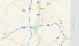
New York State Route 292 (NY 292) is a short state highway
in the Hudson Valley
of New York
, United States
, bridging Putnam
and Dutchess
Counties. The southern terminus of the route is at an intersection with NY 311
in the town of Patterson
, and the northern terminus is at a junction with NY 55
in the town of Pawling
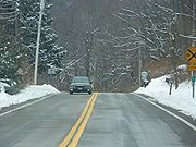
. NY 292 traverses mostly rural areas as it heads northwestward through Patterson and Pawling. Along the way, NY 292 passes along the southern and western edges of Whaley Lake
.
The portion of NY 292 between West Patterson and Whaley Lake originated as a dirt road named the Patterson – Dutchess County Line Road. This road was reconstructed in 1919 and became part of NY 39
, a highway extending from Poughkeepsie
to Patterson by way of West Pawling, in the 1920s. In the 1930 renumbering of state highways in New York, the segment of NY 39 from East Fishkill
to West Patterson was incorporated into the new NY 52
. By the end of the 1930s, the portion of NY 52 from Stormville to West Patterson was renumbered to NY 216
. In 1970, NY 216 was truncated to its current length and NY 216's former alignment from West Pawling to Patterson was renumbered to NY 292.
 Route 292 begins at NY 311
near the hamlet
of Patterson
. It heads west initially, paralleling the Putnam County
– Dutchess County
county line as it passes south of the Patterson Veteran Memorial Park and intersects County Route 63 (CR 63). It crosses a minor stream and briefly turns towards the southwest. After passing through the hamlet of West Patterson, NY 292 turns northwest, crosses the stream once again, and enters Dutchess County
. Just north of the county line in the Pawling
hamlet of Holmes, the route intersects with CR 30. Near Holmes, the highway heads due north and passes between two small ponds.
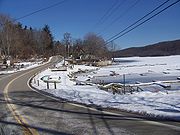
The route continues onward, traveling north through a rural, wooded area of Pawling with little development before curving west to pass along the southern edge of Whaley Lake
. At the southwestern tip of the lake, NY 292 turns north, paralleling the western and northern shores of the lake as it heads toward the hamlet of West Pawling. North of the lake in West Pawling, Route 292 turns east onto a former routing of NY 55
for a short distance before ending at modern NY 55 in the northwest corner of Pawling.
 Part of the highway was once part of the Patterson – Dutchess County Line Road, a 1.61 miles (2.59 km) dirt road that extended from Banks Corner to Whaley Lake. Plans were finalized in 1919 to rebuild the previously inadequate road; the project cost an estimated $43,500 ($517,298 2007 USD), including $15,225 ($181,054 2007 USD) of Putnam County's portion of the construction. In May 1919, the Danbury
News reported, "On the road between Sodom and Pawling turn left and run through Patterson and continue to West Patterson. From West Patterson a new road about one and one-half miles in length is under construction which connects with a good macadam road passing Whaley Pond and running to Stonehouse, thence continuing ... to Newburgh." The new road was completed in November of that year.
Route 292 was originally part of NY 39
in the 1920s, which ran from Patterson
to Poughkeepsie
via West Patterson and East Fishkill. In the 1930 renumbering, the portion of NY 39 between East Fishkill and the western fringe of Patterson was redesignated as part of the new NY 52
. Between Patterson and NY 22
, old NY 39 was renumbered to NY 311
.
Ca. 1937, NY 52 was realigned to follow its current alignment between Stormville and Lake Carmel
. The former routing of NY 52 between Stormville and Patterson became part of NY 216
. The route remained unchanged until January 1, 1970, when NY 216 was truncated to its current eastern terminus in Poughquag. As part of the truncation, its former alignment from West Pawling to Patterson was renumbered to NY 292.
State highway
State highway, state road or state route can refer to one of three related concepts, two of them related to a state or provincial government in a country that is divided into states or provinces :#A...
in the Hudson Valley
Hudson Valley
The Hudson Valley comprises the valley of the Hudson River and its adjacent communities in New York State, United States, from northern Westchester County northward to the cities of Albany and Troy.-History:...
of New York
New York
New York is a state in the Northeastern region of the United States. It is the nation's third most populous state. New York is bordered by New Jersey and Pennsylvania to the south, and by Connecticut, Massachusetts and Vermont to the east...
, United States
United States
The United States of America is a federal constitutional republic comprising fifty states and a federal district...
, bridging Putnam
Putnam County, New York
Putnam County is a county located in the U.S. state of New York, in the lower Hudson River Valley. Putnam county formed in 1812, when it detached from Dutchess County. , the population was 99,710. It is part of the New York Metropolitan Area. The county seat is the hamlet of Carmel...
and Dutchess
Dutchess County, New York
Dutchess County is a county located in the U.S. state of New York, in the state's Mid-Hudson Region of the Hudson Valley. The 2010 census lists the population as 297,488...
Counties. The southern terminus of the route is at an intersection with NY 311
New York State Route 311
New York State Route 311 is a state highway located entirely within Putnam County, New York, United States. The highway begins at NY 52 in Lake Carmel, and intersects Interstate 84 shortly thereafter...
in the town of Patterson
Patterson, New York
Patterson is a town in Putnam County, New York, United States. The town is in the northeast part of the county. Interstate 84 passes through the southwest part of the town. The population was 11,306 at the 2000 census. The town is named after early farmer Matthew Paterson...
, and the northern terminus is at a junction with NY 55
New York State Route 55
New York State Route 55 is a state highway in southern New York, running from the Pennsylvania state line at the Delaware River in Barryville to the Connecticut state line at Wingdale...
in the town of Pawling
Pawling (town), New York
Pawling is a town in Dutchess County, New York, United States. The population was 7,521 at the 2000 census. The town is named after Catherine Pauling, the daughter of Henry Beekman, who held the second largest land patent in the county. A misprint caused the U to change to a W and the name...
. NY 292 traverses mostly rural areas as it heads northwestward through Patterson and Pawling. Along the way, NY 292 passes along the southern and western edges of Whaley Lake
Whaley Lake
Whaley Lake is located in the town of Pawling in southeastern Dutchess County in New York State, United States.The lake is partially man-made as it is controlled by a dam at its northern end. The lake feeds into the Fishkill Creek which empties into the Hudson River at Beacon, New York.The Lake is...
.
The portion of NY 292 between West Patterson and Whaley Lake originated as a dirt road named the Patterson – Dutchess County Line Road. This road was reconstructed in 1919 and became part of NY 39
New York State Route 39 (1920s)
New York State Route 39 was a state highway in the Hudson Valley region of New York, United States. It stretched from NY 21 in the town of Poughkeepsie to NY 22 in Patterson, New York...
, a highway extending from Poughkeepsie
Poughkeepsie (city), New York
Poughkeepsie is a city in the state of New York, United States, which serves as the county seat of Dutchess County. Poughkeepsie is located in the Hudson River Valley midway between New York City and Albany...
to Patterson by way of West Pawling, in the 1920s. In the 1930 renumbering of state highways in New York, the segment of NY 39 from East Fishkill
East Fishkill, New York
East Fishkill is a town on the southern border of Dutchess County, New York, United States. The population was 25,589 at the 2000 census. The town name is derived from its formation from Fishkill, NY....
to West Patterson was incorporated into the new NY 52
New York State Route 52
New York State Route 52 is a long state highway in the southeastern part of New York in the United States. It generally runs from west to east, beginning at the Pennsylvania state line in the Delaware River near Narrowsburg, crossing the Hudson River on the Newburgh-Beacon Bridge, and ending...
. By the end of the 1930s, the portion of NY 52 from Stormville to West Patterson was renumbered to NY 216
New York State Route 216
New York State Route 216 is a short state highway located entirely in Dutchess County, New York, United States. At in length, it connects NY 52 and NY 55 between the hamlets of Stormville at the east end and Poughquag at the west...
. In 1970, NY 216 was truncated to its current length and NY 216's former alignment from West Pawling to Patterson was renumbered to NY 292.
Route description
New York State Route 311
New York State Route 311 is a state highway located entirely within Putnam County, New York, United States. The highway begins at NY 52 in Lake Carmel, and intersects Interstate 84 shortly thereafter...
near the hamlet
Hamlet (place)
A hamlet is usually a rural settlement which is too small to be considered a village, though sometimes the word is used for a different sort of community. Historically, when a hamlet became large enough to justify building a church, it was then classified as a village...
of Patterson
Patterson, New York
Patterson is a town in Putnam County, New York, United States. The town is in the northeast part of the county. Interstate 84 passes through the southwest part of the town. The population was 11,306 at the 2000 census. The town is named after early farmer Matthew Paterson...
. It heads west initially, paralleling the Putnam County
Putnam County, New York
Putnam County is a county located in the U.S. state of New York, in the lower Hudson River Valley. Putnam county formed in 1812, when it detached from Dutchess County. , the population was 99,710. It is part of the New York Metropolitan Area. The county seat is the hamlet of Carmel...
– Dutchess County
Dutchess County, New York
Dutchess County is a county located in the U.S. state of New York, in the state's Mid-Hudson Region of the Hudson Valley. The 2010 census lists the population as 297,488...
county line as it passes south of the Patterson Veteran Memorial Park and intersects County Route 63 (CR 63). It crosses a minor stream and briefly turns towards the southwest. After passing through the hamlet of West Patterson, NY 292 turns northwest, crosses the stream once again, and enters Dutchess County
Dutchess County, New York
Dutchess County is a county located in the U.S. state of New York, in the state's Mid-Hudson Region of the Hudson Valley. The 2010 census lists the population as 297,488...
. Just north of the county line in the Pawling
Pawling (town), New York
Pawling is a town in Dutchess County, New York, United States. The population was 7,521 at the 2000 census. The town is named after Catherine Pauling, the daughter of Henry Beekman, who held the second largest land patent in the county. A misprint caused the U to change to a W and the name...
hamlet of Holmes, the route intersects with CR 30. Near Holmes, the highway heads due north and passes between two small ponds.
The route continues onward, traveling north through a rural, wooded area of Pawling with little development before curving west to pass along the southern edge of Whaley Lake
Whaley Lake
Whaley Lake is located in the town of Pawling in southeastern Dutchess County in New York State, United States.The lake is partially man-made as it is controlled by a dam at its northern end. The lake feeds into the Fishkill Creek which empties into the Hudson River at Beacon, New York.The Lake is...
. At the southwestern tip of the lake, NY 292 turns north, paralleling the western and northern shores of the lake as it heads toward the hamlet of West Pawling. North of the lake in West Pawling, Route 292 turns east onto a former routing of NY 55
New York State Route 55
New York State Route 55 is a state highway in southern New York, running from the Pennsylvania state line at the Delaware River in Barryville to the Connecticut state line at Wingdale...
for a short distance before ending at modern NY 55 in the northwest corner of Pawling.
History
Danbury, Connecticut
Danbury is a city in northern Fairfield County, Connecticut, United States. It had population at the 2010 census of 80,893. Danbury is the fourth largest city in Fairfield County and is the seventh largest city in Connecticut....
News reported, "On the road between Sodom and Pawling turn left and run through Patterson and continue to West Patterson. From West Patterson a new road about one and one-half miles in length is under construction which connects with a good macadam road passing Whaley Pond and running to Stonehouse, thence continuing ... to Newburgh." The new road was completed in November of that year.
Route 292 was originally part of NY 39
New York State Route 39 (1920s)
New York State Route 39 was a state highway in the Hudson Valley region of New York, United States. It stretched from NY 21 in the town of Poughkeepsie to NY 22 in Patterson, New York...
in the 1920s, which ran from Patterson
Patterson, New York
Patterson is a town in Putnam County, New York, United States. The town is in the northeast part of the county. Interstate 84 passes through the southwest part of the town. The population was 11,306 at the 2000 census. The town is named after early farmer Matthew Paterson...
to Poughkeepsie
Poughkeepsie (city), New York
Poughkeepsie is a city in the state of New York, United States, which serves as the county seat of Dutchess County. Poughkeepsie is located in the Hudson River Valley midway between New York City and Albany...
via West Patterson and East Fishkill. In the 1930 renumbering, the portion of NY 39 between East Fishkill and the western fringe of Patterson was redesignated as part of the new NY 52
New York State Route 52
New York State Route 52 is a long state highway in the southeastern part of New York in the United States. It generally runs from west to east, beginning at the Pennsylvania state line in the Delaware River near Narrowsburg, crossing the Hudson River on the Newburgh-Beacon Bridge, and ending...
. Between Patterson and NY 22
New York State Route 22
New York State Route 22 is a north–south state highway in eastern New York in the United States. It runs parallel to the state's eastern edge from the outskirts of New York City to a short distance south of the Canadian border. At , it is the state's longest north–south route and...
, old NY 39 was renumbered to NY 311
New York State Route 311
New York State Route 311 is a state highway located entirely within Putnam County, New York, United States. The highway begins at NY 52 in Lake Carmel, and intersects Interstate 84 shortly thereafter...
.
Ca. 1937, NY 52 was realigned to follow its current alignment between Stormville and Lake Carmel
Lake Carmel, New York
Lake Carmel is a hamlet located in the Town of Kent in Putnam County, New York. As of the 2000 census, the population was 8,663....
. The former routing of NY 52 between Stormville and Patterson became part of NY 216
New York State Route 216
New York State Route 216 is a short state highway located entirely in Dutchess County, New York, United States. At in length, it connects NY 52 and NY 55 between the hamlets of Stormville at the east end and Poughquag at the west...
. The route remained unchanged until January 1, 1970, when NY 216 was truncated to its current eastern terminus in Poughquag. As part of the truncation, its former alignment from West Pawling to Patterson was renumbered to NY 292.