

Nevada County, Arkansas
Encyclopedia
Nevada County is a county
located in the U.S. state
of Arkansas
. As of 2010, the population was 8,997. The county seat
is Prescott
. Nevada County is Arkansas's 63rd county, formed on March 20, 1871, and named for the State of Nevada
due to the perceived similarity between their physical shapes; the Arkansas county's shape roughly follows the same outline as the state's boundary when inverted. Contrasting with the name of the U.S. state, the local pronunciation for the southwestern Arkansas county is "nuh-VAY-duh". It is an alcohol prohibition or dry county
.
Nevada County is part of the Hope
Micropolitan Statistical Area
.
Dorcheat Bayou
, a 122-mile stream, begins in Nevada County. It flows south into Columbia County and then Webster Parish
, Louisiana
, and empties into Lake Bistineau
. In the 19th century, the bayou was navigable for three to six months by steamboat
from Bistineau to Minden
. It is now popular for fishing
and natural beauty.
or Southwest Arkansas.
 As of the census
of 2000, there were 9,955 people, 3,893 households, and 2,721 families residing in the county. The population density
was 16 people per square mile (6/km²). There were 4,751 housing units at an average density of 8 per square mile (3/km²). The racial makeup of the county was 66.90% White
, 31.18% Black
or African American
, 0.38% Native American
, 0.06% Asian
, 0.85% from other races
, and 0.62% from two or more races. 1.52% of the population were Hispanic
or Latino
of any race.
There were 3,893 households out of which 31.40% had children under the age of 18 living with them, 51.90% were married couples
living together, 14.00% had a female householder with no husband present, and 30.10% were non-families. 27.80% of all households were made up of individuals and 13.70% had someone living alone who was 65 years of age or older. The average household size was 2.48 and the average family size was 3.02.
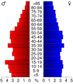
In the county the population was spread out with 25.20% under the age of 18, 8.70% from 18 to 24, 26.10% from 25 to 44, 23.80% from 45 to 64, and 16.10% who were 65 years of age or older. The median age was 38 years. For every 100 females there were 94.40 males. For every 100 females age 18 and over, there were 89.90 males.
The median income for a household in the county was $26,962, and the median income for a family was $33,095. Males had a median income of $27,888 versus $17,920 for females. The per capita income
for the county was $14,184. About 18.30% of families and 22.80% of the population were below the poverty line, including 28.00% of those under age 18 and 27.10% of those age 65 or over.
County (United States)
In the United States, a county is a geographic subdivision of a state , usually assigned some governmental authority. The term "county" is used in 48 of the 50 states; Louisiana is divided into parishes and Alaska into boroughs. Parishes and boroughs are called "county-equivalents" by the U.S...
located in the U.S. state
U.S. state
A U.S. state is any one of the 50 federated states of the United States of America that share sovereignty with the federal government. Because of this shared sovereignty, an American is a citizen both of the federal entity and of his or her state of domicile. Four states use the official title of...
of Arkansas
Arkansas
Arkansas is a state located in the southern region of the United States. Its name is an Algonquian name of the Quapaw Indians. Arkansas shares borders with six states , and its eastern border is largely defined by the Mississippi River...
. As of 2010, the population was 8,997. The county seat
County seat
A county seat is an administrative center, or seat of government, for a county or civil parish. The term is primarily used in the United States....
is Prescott
Prescott, Arkansas
Prescott is a city and the county seat of Nevada County, Arkansas. The community had a population of 3,868 at the 2000 census. Prescott is part of the Hope Micropolitan Statistical Area....
. Nevada County is Arkansas's 63rd county, formed on March 20, 1871, and named for the State of Nevada
Nevada
Nevada is a state in the western, mountain west, and southwestern regions of the United States. With an area of and a population of about 2.7 million, it is the 7th-largest and 35th-most populous state. Over two-thirds of Nevada's people live in the Las Vegas metropolitan area, which contains its...
due to the perceived similarity between their physical shapes; the Arkansas county's shape roughly follows the same outline as the state's boundary when inverted. Contrasting with the name of the U.S. state, the local pronunciation for the southwestern Arkansas county is "nuh-VAY-duh". It is an alcohol prohibition or dry county
Dry county
A dry county is a county in the United States whose government forbids the sale of alcoholic beverages. Some prohibit off-premises sale, some prohibit on-premises sale, and some prohibit both. Hundreds of dry counties exist across the United States, almost all of them in the South...
.
Nevada County is part of the Hope
Hope, Arkansas
Hope is a small city in Hempstead County, Arkansas, United States. According to 2008 United States Census Bureau estimates, the population of the city was 10,378...
Micropolitan Statistical Area
Hope micropolitan area
The Hope Micropolitan Statistical Area, as defined by the United States Census Bureau, is an area consisting of two counties in the U.S. state of Arkansas, anchored by the city of Hope....
.
Dorcheat Bayou
Dorcheat Bayou
Dorcheat Bayou, also known as Bayou Dorcheat, is a stream in the USA that extends from Nevada County in southwestern Arkansas through Columbia County and into Webster Parish in northwestern Louisiana before emptying into Lake Bistineau east of the village of Doyline. To its south, Lake Bistineau...
, a 122-mile stream, begins in Nevada County. It flows south into Columbia County and then Webster Parish
Webster Parish, Louisiana
Webster Parish is a parish located in the U.S. state of Louisiana. The seat of the parish is Minden. In 2010, its population was 41,207....
, Louisiana
Louisiana
Louisiana is a state located in the southern region of the United States of America. Its capital is Baton Rouge and largest city is New Orleans. Louisiana is the only state in the U.S. with political subdivisions termed parishes, which are local governments equivalent to counties...
, and empties into Lake Bistineau
Lake Bistineau
250px|right|thumb|Lake Bistineau south of [[Doyline, Louisiana|Doyline]], [[Louisiana]]Lake Bistineau is a long, narrow waterway of , wide and long located in Webster, Bossier, and Bienville parishes in northwestern Louisiana. The lake is fed by Dorcheat Bayou, Clark’s Bayou, and other smaller...
. In the 19th century, the bayou was navigable for three to six months by steamboat
Steamboat
A steamboat or steamship, sometimes called a steamer, is a ship in which the primary method of propulsion is steam power, typically driving propellers or paddlewheels...
from Bistineau to Minden
Minden, Louisiana
Minden is a city in the American state of Louisiana. It serves as the parish seat of Webster Parish and is located twenty-eight miles east of Shreveport, the seat of Caddo Parish. The population, which has been stable since 1960, was 13,027 at the 2000 census...
. It is now popular for fishing
Fishing
Fishing is the activity of trying to catch wild fish. Fish are normally caught in the wild. Techniques for catching fish include hand gathering, spearing, netting, angling and trapping....
and natural beauty.
Geography
According to the 2000 census, the county has a total area of 620.78 square miles (1,607.8 km²), of which 619.95 square miles (1,605.7 km²) (or 99.87%) is land and 0.83 square miles (2.1 km²) (or 0.13%) is water. Nevada County is alternately considered as part of the greater regions of South ArkansasSouth Arkansas
South Arkansas lies within the southern most portions of Arkansas Gulf Coastal Plain and Delta regions. It encompasses the lower 15 counties of the state.-History:...
or Southwest Arkansas.
Major highways
.svg.png) Interstate 30Interstate 30Interstate 30 is an Interstate Highway in the southern United States. I-30 runs from Interstate 20 west of Fort Worth, Texas, northeast via Dallas, Texas, and Texarkana, Texas, to Interstate 40 in North Little Rock, Arkansas. The route parallels U.S. Route 67 except for the portion west of...
Interstate 30Interstate 30Interstate 30 is an Interstate Highway in the southern United States. I-30 runs from Interstate 20 west of Fort Worth, Texas, northeast via Dallas, Texas, and Texarkana, Texas, to Interstate 40 in North Little Rock, Arkansas. The route parallels U.S. Route 67 except for the portion west of... U.S. Highway 67
 U.S. Highway 278
 U.S. Highway 371
 Highway 4
 Highway 19
 Highway 24
 Highway 32
 Highway 51
 Highway 53
Adjacent counties
- Clark CountyClark County, ArkansasClark County is a county located in the U.S. state of Arkansas. As of 2010, the population was 22,995. The county seat is Arkadelphia.The Arkadelphia Micropolitan Statistical Area includes all of Clark County.-Geography:...
(northeast) - Ouachita County (east)
- Columbia CountyColumbia County, ArkansasColumbia County is a county located in the U.S. state of Arkansas. As of 2010, the population was 24,552. The county seat is Magnolia. Columbia County was formed on December 17, 1852, and was named for Christopher Columbus...
(south) - Lafayette County (southwest)
- Hempstead County (west)
- Pike CountyPike County, ArkansasPike County is a county located in the U.S. state of Arkansas. As of 2010, the population was 11,291. The county seat is Murfreesboro. Pike County is Arkansas's 25th county, formed on November 1, 1833, and named for Lieutenant Zebulon Pike, the explorer who discovered Pikes Peak...
(northwest)
Demographics
Census
A census is the procedure of systematically acquiring and recording information about the members of a given population. It is a regularly occurring and official count of a particular population. The term is used mostly in connection with national population and housing censuses; other common...
of 2000, there were 9,955 people, 3,893 households, and 2,721 families residing in the county. The population density
Population density
Population density is a measurement of population per unit area or unit volume. It is frequently applied to living organisms, and particularly to humans...
was 16 people per square mile (6/km²). There were 4,751 housing units at an average density of 8 per square mile (3/km²). The racial makeup of the county was 66.90% White
Race (United States Census)
Race and ethnicity in the United States Census, as defined by the Federal Office of Management and Budget and the United States Census Bureau, are self-identification data items in which residents choose the race or races with which they most closely identify, and indicate whether or not they are...
, 31.18% Black
Race (United States Census)
Race and ethnicity in the United States Census, as defined by the Federal Office of Management and Budget and the United States Census Bureau, are self-identification data items in which residents choose the race or races with which they most closely identify, and indicate whether or not they are...
or African American
Race (United States Census)
Race and ethnicity in the United States Census, as defined by the Federal Office of Management and Budget and the United States Census Bureau, are self-identification data items in which residents choose the race or races with which they most closely identify, and indicate whether or not they are...
, 0.38% Native American
Race (United States Census)
Race and ethnicity in the United States Census, as defined by the Federal Office of Management and Budget and the United States Census Bureau, are self-identification data items in which residents choose the race or races with which they most closely identify, and indicate whether or not they are...
, 0.06% Asian
Race (United States Census)
Race and ethnicity in the United States Census, as defined by the Federal Office of Management and Budget and the United States Census Bureau, are self-identification data items in which residents choose the race or races with which they most closely identify, and indicate whether or not they are...
, 0.85% from other races
Race (United States Census)
Race and ethnicity in the United States Census, as defined by the Federal Office of Management and Budget and the United States Census Bureau, are self-identification data items in which residents choose the race or races with which they most closely identify, and indicate whether or not they are...
, and 0.62% from two or more races. 1.52% of the population were Hispanic
Race (United States Census)
Race and ethnicity in the United States Census, as defined by the Federal Office of Management and Budget and the United States Census Bureau, are self-identification data items in which residents choose the race or races with which they most closely identify, and indicate whether or not they are...
or Latino
Race (United States Census)
Race and ethnicity in the United States Census, as defined by the Federal Office of Management and Budget and the United States Census Bureau, are self-identification data items in which residents choose the race or races with which they most closely identify, and indicate whether or not they are...
of any race.
There were 3,893 households out of which 31.40% had children under the age of 18 living with them, 51.90% were married couples
Marriage
Marriage is a social union or legal contract between people that creates kinship. It is an institution in which interpersonal relationships, usually intimate and sexual, are acknowledged in a variety of ways, depending on the culture or subculture in which it is found...
living together, 14.00% had a female householder with no husband present, and 30.10% were non-families. 27.80% of all households were made up of individuals and 13.70% had someone living alone who was 65 years of age or older. The average household size was 2.48 and the average family size was 3.02.
In the county the population was spread out with 25.20% under the age of 18, 8.70% from 18 to 24, 26.10% from 25 to 44, 23.80% from 45 to 64, and 16.10% who were 65 years of age or older. The median age was 38 years. For every 100 females there were 94.40 males. For every 100 females age 18 and over, there were 89.90 males.
The median income for a household in the county was $26,962, and the median income for a family was $33,095. Males had a median income of $27,888 versus $17,920 for females. The per capita income
Per capita income
Per capita income or income per person is a measure of mean income within an economic aggregate, such as a country or city. It is calculated by taking a measure of all sources of income in the aggregate and dividing it by the total population...
for the county was $14,184. About 18.30% of families and 22.80% of the population were below the poverty line, including 28.00% of those under age 18 and 27.10% of those age 65 or over.
Cities and towns
|
Cale, Arkansas Cale is a town in Nevada County, Arkansas, United States. The population was 75 at the 2000 census. It is part of the Hope Micropolitan Statistical Area.The town was named after Cale Wardell.-Geography:Cale is located at .... Emmet, Arkansas Emmet is a city in Hempstead and Nevada counties in the U.S. state of Arkansas. The population was 506 at the 2000 census.-Geography:Emmet is located at .... |
Prescott, Arkansas Prescott is a city and the county seat of Nevada County, Arkansas. The community had a population of 3,868 at the 2000 census. Prescott is part of the Hope Micropolitan Statistical Area.... Rosston, Arkansas Rosston is a town in Nevada County, Arkansas, United States. The population was 265 at the 2000 census. It is part of the Hope Micropolitan Statistical Area.-Geography:Rosston is located at .... |
Willisville, Arkansas Willisville is a town in Nevada County, Arkansas, United States. The population was 188 at the 2000 census. It is part of the Hope Micropolitan Statistical Area.-Geography:Willisville is located at .... |
Townships
- Alabama
- Albany
- Boughton
- Caney (CaleCale, ArkansasCale is a town in Nevada County, Arkansas, United States. The population was 75 at the 2000 census. It is part of the Hope Micropolitan Statistical Area.The town was named after Cale Wardell.-Geography:Cale is located at ....
, RosstonRosston, ArkansasRosston is a town in Nevada County, Arkansas, United States. The population was 265 at the 2000 census. It is part of the Hope Micropolitan Statistical Area.-Geography:Rosston is located at ....
) - Emmet (EmmetEmmet, ArkansasEmmet is a city in Hempstead and Nevada counties in the U.S. state of Arkansas. The population was 506 at the 2000 census.-Geography:Emmet is located at ....
) - Georgia
- Jackson
- Leake
- Missouri (PrescottPrescott, ArkansasPrescott is a city and the county seat of Nevada County, Arkansas. The community had a population of 3,868 at the 2000 census. Prescott is part of the Hope Micropolitan Statistical Area....
) - Parker (BodcawBodcaw, ArkansasBodcaw is a town in Nevada County, Arkansas, United States. The population was 154 at the 2000 census. It is part of the Hope Micropolitan Statistical Area.-Geography:Bodcaw is located at ....
) - Redland
- Taylor (WillisvilleWillisville, ArkansasWillisville is a town in Nevada County, Arkansas, United States. The population was 188 at the 2000 census. It is part of the Hope Micropolitan Statistical Area.-Geography:Willisville is located at ....
) - Union (Bluff CityBluff City, ArkansasBluff City is a town in Nevada County, Arkansas, United States. The population was 158 at the 2000 census. It is part of the Hope Micropolitan Statistical Area.-Geography:According to the United States Census Bureau, the town has a total area of , all land....
, CDP ReaderReader, ArkansasReader is an unincorporated census-designated place in Nevada and Ouachita counties in the U.S. state of Arkansas. As of the 2010 census, its population is 66. The population was 82 at the 2000 census, at which time it was a town...
)