

Columbia County, Arkansas
Encyclopedia

Columbia County is a county
County (United States)
In the United States, a county is a geographic subdivision of a state , usually assigned some governmental authority. The term "county" is used in 48 of the 50 states; Louisiana is divided into parishes and Alaska into boroughs. Parishes and boroughs are called "county-equivalents" by the U.S...
located in the U.S. state
U.S. state
A U.S. state is any one of the 50 federated states of the United States of America that share sovereignty with the federal government. Because of this shared sovereignty, an American is a citizen both of the federal entity and of his or her state of domicile. Four states use the official title of...
of Arkansas
Arkansas
Arkansas is a state located in the southern region of the United States. Its name is an Algonquian name of the Quapaw Indians. Arkansas shares borders with six states , and its eastern border is largely defined by the Mississippi River...
. As of 2010, the population was 24,552. The county seat
County seat
A county seat is an administrative center, or seat of government, for a county or civil parish. The term is primarily used in the United States....
is Magnolia
Magnolia, Arkansas
Magnolia is a city in Columbia County, Arkansas, United States, that was founded in 1853. At the time of its incorporation in 1858, the city had a population of about 1,950. The city grew slowly as an agricultural and regional cotton market until the discovery of oil just east of the city in March,...
. Columbia County was formed on December 17, 1852, and was named for Christopher Columbus. It is an alcohol prohibition or dry county
Dry county
A dry county is a county in the United States whose government forbids the sale of alcoholic beverages. Some prohibit off-premises sale, some prohibit on-premises sale, and some prohibit both. Hundreds of dry counties exist across the United States, almost all of them in the South...
.
The Magnolia Micropolitan Statistical Area includes all of Columbia County.
Geography
According to the 2000 census, the county has a total area of 766.86 square miles (1,986.2 km²), of which 766.11 square miles (1,984.2 km²) (or 99.90%) is land and 0.75 square miles (1.9 km²) (or 0.10%) is water. Columbia County is in South ArkansasSouth Arkansas
South Arkansas lies within the southern most portions of Arkansas Gulf Coastal Plain and Delta regions. It encompasses the lower 15 counties of the state.-History:...
. Columbia County, along with Union County, is home to the largest Bromine
Bromine
Bromine ") is a chemical element with the symbol Br, an atomic number of 35, and an atomic mass of 79.904. It is in the halogen element group. The element was isolated independently by two chemists, Carl Jacob Löwig and Antoine Jerome Balard, in 1825–1826...
reserve in the United States
United States
The United States of America is a federal constitutional republic comprising fifty states and a federal district...
.
Dorcheat Bayou
Dorcheat Bayou
Dorcheat Bayou, also known as Bayou Dorcheat, is a stream in the USA that extends from Nevada County in southwestern Arkansas through Columbia County and into Webster Parish in northwestern Louisiana before emptying into Lake Bistineau east of the village of Doyline. To its south, Lake Bistineau...
flows through Columbia County from its origin in Nevada County southward into Webster Parish
Webster Parish, Louisiana
Webster Parish is a parish located in the U.S. state of Louisiana. The seat of the parish is Minden. In 2010, its population was 41,207....
, Louisiana
Louisiana
Louisiana is a state located in the southern region of the United States of America. Its capital is Baton Rouge and largest city is New Orleans. Louisiana is the only state in the U.S. with political subdivisions termed parishes, which are local governments equivalent to counties...
, before emptying into Lake Bistineau
Lake Bistineau
250px|right|thumb|Lake Bistineau south of [[Doyline, Louisiana|Doyline]], [[Louisiana]]Lake Bistineau is a long, narrow waterway of , wide and long located in Webster, Bossier, and Bienville parishes in northwestern Louisiana. The lake is fed by Dorcheat Bayou, Clark’s Bayou, and other smaller...
.
Adjacent counties
- Nevada County (north)
- Ouachita County (northeast)
- Union County (east)
- Claiborne ParishClaiborne Parish, LouisianaClaiborne Parish is a parish located in the U.S. state of Louisiana. The parish seat is Homer and as of 2000, the population is 16,851.-History:The parish is named for the first Louisiana governor, William C. C. Claiborne....
, LouisianaLouisianaLouisiana is a state located in the southern region of the United States of America. Its capital is Baton Rouge and largest city is New Orleans. Louisiana is the only state in the U.S. with political subdivisions termed parishes, which are local governments equivalent to counties...
(southeast) - Webster ParishWebster Parish, LouisianaWebster Parish is a parish located in the U.S. state of Louisiana. The seat of the parish is Minden. In 2010, its population was 41,207....
, LouisianaLouisianaLouisiana is a state located in the southern region of the United States of America. Its capital is Baton Rouge and largest city is New Orleans. Louisiana is the only state in the U.S. with political subdivisions termed parishes, which are local governments equivalent to counties...
(south) - Lafayette County (west)
Major highways
-
 U.S. Highway 79
 -
 U.S. Highway 82
 -
 U.S. Highway 371
 -
 Highway 19
 -
 Highway 98
 -
 Highway 160
Airports
Magnolia Municipal AirportMagnolia Municipal Airport
Magnolia Municipal Airport is a city-owned, public-use airport located three nautical miles southeast of the central business district of Magnolia, in Columbia County, Arkansas, United States.- Facilities and aircraft :...
is a public-use airport
Airport
An airport is a location where aircraft such as fixed-wing aircraft, helicopters, and blimps take off and land. Aircraft may be stored or maintained at an airport...
in Columbia County. It is owned by the city of Magnolia and located three nautical miles (6 km) southeast of its central business district
Central business district
A central business district is the commercial and often geographic heart of a city. In North America this part of a city is commonly referred to as "downtown" or "city center"...
.
Demographics
Census
A census is the procedure of systematically acquiring and recording information about the members of a given population. It is a regularly occurring and official count of a particular population. The term is used mostly in connection with national population and housing censuses; other common...
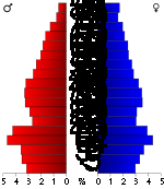
of 2000, there were 25,603 people, 9,981 households, and 6,747 families residing in the county. The population density
Population density
Population density is a measurement of population per unit area or unit volume. It is frequently applied to living organisms, and particularly to humans...
was 33 people per square mile (13/km²). There were 11,566 housing units at an average density of 15 per square mile (6/km²). The racial makeup of the county was 62.08% White
Race (United States Census)
Race and ethnicity in the United States Census, as defined by the Federal Office of Management and Budget and the United States Census Bureau, are self-identification data items in which residents choose the race or races with which they most closely identify, and indicate whether or not they are...
, 36.06% Black
Race (United States Census)
Race and ethnicity in the United States Census, as defined by the Federal Office of Management and Budget and the United States Census Bureau, are self-identification data items in which residents choose the race or races with which they most closely identify, and indicate whether or not they are...
or African American
Race (United States Census)
Race and ethnicity in the United States Census, as defined by the Federal Office of Management and Budget and the United States Census Bureau, are self-identification data items in which residents choose the race or races with which they most closely identify, and indicate whether or not they are...
, 0.26% Native American
Race (United States Census)
Race and ethnicity in the United States Census, as defined by the Federal Office of Management and Budget and the United States Census Bureau, are self-identification data items in which residents choose the race or races with which they most closely identify, and indicate whether or not they are...
, 0.34% Asian
Race (United States Census)
Race and ethnicity in the United States Census, as defined by the Federal Office of Management and Budget and the United States Census Bureau, are self-identification data items in which residents choose the race or races with which they most closely identify, and indicate whether or not they are...
, 0.03% Pacific Islander
Race (United States Census)
Race and ethnicity in the United States Census, as defined by the Federal Office of Management and Budget and the United States Census Bureau, are self-identification data items in which residents choose the race or races with which they most closely identify, and indicate whether or not they are...
, 0.46% from other races
Race (United States Census)
Race and ethnicity in the United States Census, as defined by the Federal Office of Management and Budget and the United States Census Bureau, are self-identification data items in which residents choose the race or races with which they most closely identify, and indicate whether or not they are...
, and 0.77% from two or more races. 1.05% of the population were Hispanic
Race (United States Census)
Race and ethnicity in the United States Census, as defined by the Federal Office of Management and Budget and the United States Census Bureau, are self-identification data items in which residents choose the race or races with which they most closely identify, and indicate whether or not they are...
or Latino
Race (United States Census)
Race and ethnicity in the United States Census, as defined by the Federal Office of Management and Budget and the United States Census Bureau, are self-identification data items in which residents choose the race or races with which they most closely identify, and indicate whether or not they are...
of any race.
There were 9,981 households out of which 30.10% had children under the age of 18 living with them, 48.90% were married couples
Marriage
Marriage is a social union or legal contract between people that creates kinship. It is an institution in which interpersonal relationships, usually intimate and sexual, are acknowledged in a variety of ways, depending on the culture or subculture in which it is found...
living together, 15.10% had a female householder with no husband present, and 32.40% were non-families. 29.20% of all households were made up of individuals and 13.80% had someone living alone who was 65 years of age or older. The average household size was 2.45 and the average family size was 3.03.
In the county the population was spread out with 25.10% under the age of 18, 12.30% from 18 to 24, 25.30% from 25 to 44, 21.40% from 45 to 64, and 15.90% who were 65 years of age or older. The median age was 36 years. For every 100 females there were 90.90 males. For every 100 females age 18 and over, there were 86.70 males.
The median income for a household in the county was $27,640, and the median income for a family was $36,271. Males had a median income of $31,313 versus $20,099 for females. The per capita income
Per capita income
Per capita income or income per person is a measure of mean income within an economic aggregate, such as a country or city. It is calculated by taking a measure of all sources of income in the aggregate and dividing it by the total population...
for the county was $15,322. About 15.80% of families and 21.10% of the population were below the poverty line, including 28.70% of those under age 18 and 20.00% of those age 65 or over.
Cities and towns
|
McNeil, Arkansas McNeil is a city in Columbia County, Arkansas, United States. The population was 662 at the 2000 census.The community was named for William B. McNeil, founder of the College Hill Academy.-Geography:McNeil is located at .... Taylor, Arkansas Taylor is a city in Columbia County, Arkansas, United States. The population was 566 at the 2000 census.-Geography:Taylor is located at .According to the United States Census Bureau, the city has a total area of , all of it land.... |
Waldo, Arkansas Waldo is a city in Columbia County, Arkansas, United States. The population was 1,594 at the 2000 census.Waldo celebrated its 120th year as a city in 2007. The small town was once a booming rail city on the Cotton Belt train route... |
Townships
- Emerson (EmersonEmerson, ArkansasEmerson is a town in Columbia County, Arkansas, United States. The population was 359 at the 2000 census.-Geography:Emerson is located at ....
) - McNeil (McNeilMcNeil, ArkansasMcNeil is a city in Columbia County, Arkansas, United States. The population was 662 at the 2000 census.The community was named for William B. McNeil, founder of the College Hill Academy.-Geography:McNeil is located at ....
, small part of MagnoliaMagnolia, ArkansasMagnolia is a city in Columbia County, Arkansas, United States, that was founded in 1853. At the time of its incorporation in 1858, the city had a population of about 1,950. The city grew slowly as an agricultural and regional cotton market until the discovery of oil just east of the city in March,...
) - Magnolia (most of MagnoliaMagnolia, ArkansasMagnolia is a city in Columbia County, Arkansas, United States, that was founded in 1853. At the time of its incorporation in 1858, the city had a population of about 1,950. The city grew slowly as an agricultural and regional cotton market until the discovery of oil just east of the city in March,...
) - Taylor (TaylorTaylor, ArkansasTaylor is a city in Columbia County, Arkansas, United States. The population was 566 at the 2000 census.-Geography:Taylor is located at .According to the United States Census Bureau, the city has a total area of , all of it land....
) - Village
- Waldo (WaldoWaldo, ArkansasWaldo is a city in Columbia County, Arkansas, United States. The population was 1,594 at the 2000 census.Waldo celebrated its 120th year as a city in 2007. The small town was once a booming rail city on the Cotton Belt train route...
)