

National Register of Historic Places listings in Valdez-Cordova Census Area, Alaska
Encyclopedia

This is intended to be a complete list of the properties and districts on the National Register of Historic Places
National Register of Historic Places
The National Register of Historic Places is the United States government's official list of districts, sites, buildings, structures, and objects deemed worthy of preservation...
in Valdez-Cordova Census Area
Valdez-Cordova Census Area, Alaska
Valdez-Cordova Census Area is a census area located in the state of Alaska, United States. As of the 2000 census, the population was 10,195. It is part of the unorganized borough and therefore has no borough seat...
, Alaska
Alaska
Alaska is the largest state in the United States by area. It is situated in the northwest extremity of the North American continent, with Canada to the east, the Arctic Ocean to the north, and the Pacific Ocean to the west and south, with Russia further west across the Bering Strait...
, United States
United States
The United States of America is a federal constitutional republic comprising fifty states and a federal district...
. The locations of National Register properties and districts for which the latitude and longitude coordinates are included below, may be seen in a Google map.
There are 25 properties and districts listed on the National Register in the census area, including three National Historic Landmark
National Historic Landmark
A National Historic Landmark is a building, site, structure, object, or district, that is officially recognized by the United States government for its historical significance...
s.
Current listings
| Landmark name | Image | Date listed | Location | Community | Summary | |
|---|---|---|---|---|---|---|
| 1 | Bering Expedition Landing Site Kayak Island Kayak Island , which includes the Bering Expedition Landing Site, is located in the Gulf of Alaska, 100 km SE of Cordova, Alaska Malaspina Coastal Plain. It has a land area of 73.695 km² and no population.... |
South of Katalla on Kayak Island Kayak Island Kayak Island , which includes the Bering Expedition Landing Site, is located in the Gulf of Alaska, 100 km SE of Cordova, Alaska Malaspina Coastal Plain. It has a land area of 73.695 km² and no population.... 59°53′40"N 144°29′8"W |
Katalla Katalla, Alaska Katalla is a ghost town in the Valdez-Cordova Census Area in the U.S. state of Alaska, southeast of Cordova. The name of this town was sometimes spelled Catalla. It is now abandoned.- Geography :... |
|||
| 2 | Bremner Historic Mining District Bremner Historic Mining District The Bremner Historic Mining District is a mining camp in Wrangell-St. Elias National Park and Preserve in Alaska. It is named after John Bremner, who in 1884-1885 was the first non-native person to live in the area and who prospected for gold along the Bremner River... |
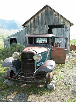 |
Wrangell-St. Elias National Park and Preserve Wrangell-St. Elias National Park and Preserve Wrangell–St. Elias National Park and Preserve is a United States National Park in southeastern Alaska. It was established in 1980 by the Alaska National Interest Lands Conservation Act. The park area is included in an International Biosphere Reserve and is part of a UNESCO World Heritage Site... 61°1′28"N 143°26′24"W |
Chitina Chitina, Alaska Chitina is a census-designated place in Valdez-Cordova Census Area, Alaska, United States. At the 2000 census the population was 123.-Geography:Chitina is located at .... |
||
| 3 | Cape Hinchinbrook Light Station | Southwestern corner of Hinchinbrook Island Hinchinbrook Island Hinchinbrook Island lies east of Cardwell and north of Lucinda, Queensland Australia. Hinchinbrook Island is part of the Great Barrier Reef Marine Park and wholly protected within the Hinchinbrook Island National Park, except for a small resort. It is the largest island on the Great Barrier Reef... on the eastern side of the Hinchinbrook Entrance of Prince William Sound Prince William Sound Prince William Sound is a sound off the Gulf of Alaska on the south coast of the U.S. state of Alaska. It is located on the east side of the Kenai Peninsula. Its largest port is Valdez, at the southern terminus of the Trans-Alaska Pipeline System... 60°2′25"N 146°38′46"W |
Cordova Cordova, Alaska As of the census of 2000, there were 2,454 people, 958 households, and 597 families residing in the city. The population density was 40.0 per square mile . There are 1,099 housing units at an average density of 17.9 per square mile... |
|||
| 4 | Cape St. Elias Light Cape St. Elias Light -History:Congress approved the construction of a light station at Cape St. Elias in October 1913, appropriating $115,000 for the construction. construction began in 1915 and a third order Fresnel lens was installed. In 1927 the station was equipped with radio beacon facilities, which was the second... house |
South of Katalla on Kayak Island Kayak Island Kayak Island , which includes the Bering Expedition Landing Site, is located in the Gulf of Alaska, 100 km SE of Cordova, Alaska Malaspina Coastal Plain. It has a land area of 73.695 km² and no population.... 59°48′27"N 144°36′40"W |
Katalla Katalla, Alaska Katalla is a ghost town in the Valdez-Cordova Census Area in the U.S. state of Alaska, southeast of Cordova. The name of this town was sometimes spelled Catalla. It is now abandoned.- Geography :... |
|||
| 5 | Chilkat Oil Company Refinery Site | Katalla Rd. 60°11′19"N 144°27′0"W |
Katalla Katalla, Alaska Katalla is a ghost town in the Valdez-Cordova Census Area in the U.S. state of Alaska, southeast of Cordova. The name of this town was sometimes spelled Catalla. It is now abandoned.- Geography :... |
|||
| 6 | Chisana Historic District Chisana, Alaska Chisana is a census-designated place in the Valdez-Cordova Census Area in the U.S. state of Alaska. As of the 2010 Census, the population of the CDP was 0... |
Extending west ¼ mile from the southeastern end of Chisana Airstrip Chisana Airport Chisana Airport is a state-owned public-use airport located in Chisana, in the Valdez-Cordova Census Area of the U.S. state of Alaska. Commercial service is subsidized by the Essential Air Service program.... and parallel to Johnson Creek 62°3′57"N 142°2′34"W |
Chisana Chisana, Alaska Chisana is a census-designated place in the Valdez-Cordova Census Area in the U.S. state of Alaska. As of the 2010 Census, the population of the CDP was 0... |
|||
| 7 | Chistochina Trading Post | Junction of the Glenn Highway Glenn Highway -References:* Pasch, A. D., K. C. May. 2001. Taphonomy and paleoenvironment of hadrosaur from the Matanuska Formation in South-Central Alaska. In: Mesozioc Vertebrate Life. Ed.s Tanke, D. H., Carpenter, K., Skrepnick, M. W. Indiana University Press. Pages 219-236.-External links:**... and the Tok Cutoff 62°34′7"N 144°40′59"W |
Gakona Gakona, Alaska Gakona is a census-designated place in the Valdez-Cordova Census Area in the U.S. state of Alaska. As of the 2000 census, the population of the CDP was 215.-Geography and climate:... |
|||
| 8 | Chitina Tin Shop | Main St. 61°31′3"N 144°26′23"W |
Chitina Chitina, Alaska Chitina is a census-designated place in Valdez-Cordova Census Area, Alaska, United States. At the 2000 census the population was 123.-Geography:Chitina is located at .... |
|||
| 9 | Copper River and Northwestern Railway Copper River and Northwestern Railway The Copper River and Northwestern Railway was a railroad built by the Kennecott Corporation between 1907 and 1911 to take copper ore from Kennicott, Alaska to Cordova, Alaska, a distance of . The railroad was built by thousands of workers, who laid tracks around glaciers, across canyons and... |
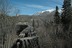 |
Beginning at Chitina and following the Copper River Copper River (Alaska) The Copper River or Ahtna River is a 300-mile river in south-central Alaska in the United States. It drains a large region of the Wrangell Mountains and Chugach Mountains into the Gulf of Alaska... to the Tasnuna River 61°17′34"N 144°42′48"W |
Chitina Chitina, Alaska Chitina is a census-designated place in Valdez-Cordova Census Area, Alaska, United States. At the 2000 census the population was 123.-Geography:Chitina is located at .... |
||
| 10 | Copper River and Northwestern Railway Bunkhouse and Messhouse | 3rd St. 61°30′58"N 144°26′2"W |
Chitina Chitina, Alaska Chitina is a census-designated place in Valdez-Cordova Census Area, Alaska, United States. At the 2000 census the population was 123.-Geography:Chitina is located at .... |
|||
| 11 | Cordova Post Office and Courthouse Cordova Post Office and Courthouse The Cordova Post Office and Courthouse in Cordova, Alaska was built in 1924. It was listed on the National Register of Historic Places in 1977.In 1977, it was reported to be the oldest post office building in Alaska still in use as a post office.... |
2nd St. 60°32′42"N 145°45′18"W |
Cordova Cordova, Alaska As of the census of 2000, there were 2,454 people, 958 households, and 597 families residing in the city. The population density was 40.0 per square mile . There are 1,099 housing units at an average density of 17.9 per square mile... |
|||
| 12 | Dakah De'nin's Village Site | Address Restricted | Chitina Chitina, Alaska Chitina is a census-designated place in Valdez-Cordova Census Area, Alaska, United States. At the 2000 census the population was 123.-Geography:Chitina is located at .... |
|||
| 13 | Gakona Historic District | Mile 2 on the Tok Cutoff-Glenn Highway Glenn Highway -References:* Pasch, A. D., K. C. May. 2001. Taphonomy and paleoenvironment of hadrosaur from the Matanuska Formation in South-Central Alaska. In: Mesozioc Vertebrate Life. Ed.s Tanke, D. H., Carpenter, K., Skrepnick, M. W. Indiana University Press. Pages 219-236.-External links:**... 62°18′10"N 145°18′12"W |
Gakona Gakona, Alaska Gakona is a census-designated place in the Valdez-Cordova Census Area in the U.S. state of Alaska. As of the 2000 census, the population of the CDP was 215.-Geography and climate:... |
|||
| 14 | Gakona Roadhouse | Mile 205 on the Glenn Highway Glenn Highway -References:* Pasch, A. D., K. C. May. 2001. Taphonomy and paleoenvironment of hadrosaur from the Matanuska Formation in South-Central Alaska. In: Mesozioc Vertebrate Life. Ed.s Tanke, D. H., Carpenter, K., Skrepnick, M. W. Indiana University Press. Pages 219-236.-External links:**... 62°18′10"N 145°18′16"W |
Gakona Gakona, Alaska Gakona is a census-designated place in the Valdez-Cordova Census Area in the U.S. state of Alaska. As of the 2000 census, the population of the CDP was 215.-Geography and climate:... |
|||
| 15 | Kansky's | Mile 42 on Skookum Rd., approximately 2 miles north of the Nabesna Mine 62°22′46"N 142°59′33"W |
Slana Slana, Alaska Slana is a census-designated place in the Valdez-Cordova Census Area in the Unorganized Borough of the U.S. state of Alaska. As of the 2000 census, the population of the CDP was 124.-History:... |
|||
| 16 | Kennecott Mines | 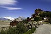 |
Southeast of the Kennecott Glacier on the northern bank of National Creek 61°30′36"N 142°52′5"W |
Kennecott | ||
| 17 | McCarthy General Store | Kennecott and Sholai Sts. 61°26′3"N 142°55′16"W |
McCarthy McCarthy, Alaska McCarthy is a census-designated place in Valdez-Cordova Census Area, Alaska, United States. The population was 42 at the 2000 census.- Geography and location:... |
|||
| 18 | McCarthy Power Plant | At McCarthy Creek 61°25′57"N 142°55′30"W |
McCarthy McCarthy, Alaska McCarthy is a census-designated place in Valdez-Cordova Census Area, Alaska, United States. The population was 42 at the 2000 census.- Geography and location:... |
|||
| 19 | Million Dollar Bridge | 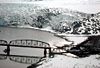 |
Mile 48 on the Copper River Highway Copper River Highway The Copper River Highway extends from Cordova along the old railbed of the Copper River and Northwestern Railway. Construction began in 1945, and was originally intended to link Cordova with the state highway system at Chitina. The Million Dollar Bridge, which had carried trains until the CR&NW... 60°40′24"N 144°44′36"W |
Cordova Cordova, Alaska As of the census of 2000, there were 2,454 people, 958 households, and 597 families residing in the city. The population density was 40.0 per square mile . There are 1,099 housing units at an average density of 17.9 per square mile... |
||
| 20 | Palugvik Archeological District Palugvik Site Palugvik Site, also known as Palugvik Archeological District, is an archaeological site on Hawkins Island in Prince William Sound, near Cordova, Alaska.It was declared a National Historic Landmark in 1962.... |
Address Restricted | Cordova Cordova, Alaska As of the census of 2000, there were 2,454 people, 958 households, and 597 families residing in the city. The population density was 40.0 per square mile . There are 1,099 housing units at an average density of 17.9 per square mile... |
|||
| 21 | Reception Building | 2nd and B Sts. 60°33′10"N 145°45′2"W |
Cordova Cordova, Alaska As of the census of 2000, there were 2,454 people, 958 households, and 597 families residing in the city. The population density was 40.0 per square mile . There are 1,099 housing units at an average density of 17.9 per square mile... |
|||
| 22 | Red Dragon Historic District | Lake St. 60°32′31"N 145°45′21"W |
Cordova Cordova, Alaska As of the census of 2000, there were 2,454 people, 958 households, and 597 families residing in the city. The population density was 40.0 per square mile . There are 1,099 housing units at an average density of 17.9 per square mile... |
|||
| 23 | St. Michael the Archangel Church | In Cordova 60°32′33"N 145°44′16"W |
Cordova Cordova, Alaska As of the census of 2000, there were 2,454 people, 958 households, and 597 families residing in the city. The population density was 40.0 per square mile . There are 1,099 housing units at an average density of 17.9 per square mile... |
|||
| 24 | Tangle Lakes Archeological District | Address Restricted | Paxson Paxson, Alaska Paxson is a census-designated place in Valdez-Cordova Census Area, Alaska, United States. As of the 2000 census, its population was 43. It is located on the Richardson Highway at the junction with the Denali Highway.-Geography:... |
|||
| 25 | Valdez Trail-Copper Bluff Segment | Milepost 106.5 on the Richardson Highway Richardson Highway The Richardson Highway is a highway in the U.S. state of Alaska, running 368 miles from Valdez to Fairbanks. It is marked as Alaska Route 4 from Valdez to Delta Junction and as Alaska Route 2 from there to Fairbanks. It is also connects segments of Alaska Route 1 between the Glenn Highway and the... 62°1′16"N 145°21′52"W |
Copper City |
See also
- List of National Historic Landmarks in Alaska
- National Register of Historic Places listings in Alaska