
.gif)
National Highway 17 (India)
Encyclopedia
National Highway 17, commonly referred to as NH 17, now renamed as NH 66, is a busy National Highway in India
that runs roughly north-south along the western coast of India
, parallel to western ghats
. It connects Panvel
, near Mumbai
to Kochi
, passing through the states of Maharashtra
, Goa
, Karnataka
, and Kerala
. It is the 7th longest highway in India with 1296 km (805.3 mi).
, at junction of NH 4
, and ends at Edappally
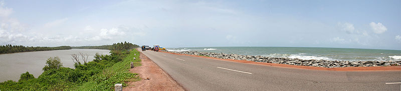
,at junction of NH 47 near Kochi. NH 17 mainly traverses through the west coast of India, sometimes touching shores of Arabian sea
. The NH 17 touches the Arabian sea at Maravanthe
in Karnataka and Thalassery
in Kerala. It passes through the India
n states of Maharashtra
, Goa
, Karnataka
and Kerala
.
The National Highway 17 connects cities and towns of different states as follows Panvel
, Mahad
, Khed, Chiplun
, Hatkhamba (Ratnagiri
), Rajapur, Panaji, Margao
, Karwar
, Kumta
, Bhatkal
, Kundapura
, Udupi, Surathkal
, Mangalore
, Kasaragod, Kannur
, Thalassery
, Vadakara, Kozhikkode, Kottakkal
, Ponnani
, Kodungallur
, North Paravur
and Edappally
in Kochi.
and Mangalore
calling at different ports were only means of transport along the west coast of India adjoining the Arabian sea. These ship services was abandoned later. The NH 17 connects the interior parts of coastal regions with rest of the country. The NH 17 connects the major sea ports of West India, Mumbai, JNPT at Nhava Sheva, Mormugao (MPT), New Mangalore (NMPT), International Container Transshipment Terminal, Kochi
, Ratnagiri
Port , Jindal jaigad port.
Hence this national highway 17 allows for movement of goods by trucks ( lorries ) from hinterland to major sea ports of India.The trade and commerce in the region has increased due to expansion of markets for agricultural and sea food produced in the region connected by this highway. The formation of NH-17 has led to development of tourism in the region connected by this highway. Goa state is classic example of this development. Many industries have been set up along National Highway 17 taking advantage of connectivity and proximity to sea ports on Arabian sea. The highway was the only source of connection between areas in the coastal districts, until the Konkan Railway
was opened in 1998, between Mumbai and Mangalore.
Maharashtra
Goa
Karnataka
North Kanara District
South Kanara (Udupi and Mangalore District)
Kerala
trees dotted all along with paddy field
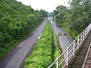
s and arecanut gardens. The road is uneven, bumps, curves, steep rises and narrow paths in between hillocks are found all over this highway. As this region experiences heavy rainfall, potholes are present occasionally.
Even though language spoken varies along the highway, food of the people along the NH 17 has some common ingredients like Coconut, Chilli, Pepper, Coconut oil, Fish etc. The region has higher literacy rate as compared to other regions of India. The building of National Highway 17 has led to rapid development of towns and cities along the highway.
India
India , officially the Republic of India , is a country in South Asia. It is the seventh-largest country by geographical area, the second-most populous country with over 1.2 billion people, and the most populous democracy in the world...
that runs roughly north-south along the western coast of India
India
India , officially the Republic of India , is a country in South Asia. It is the seventh-largest country by geographical area, the second-most populous country with over 1.2 billion people, and the most populous democracy in the world...
, parallel to western ghats
Western Ghats
The Western Ghats, Western Ghauts or the Sahyādri is a mountain range along the western side of India. It runs north to south along the western edge of the Deccan Plateau, and separates the plateau from a narrow coastal plain along the Arabian Sea. The Western Ghats block rainfall to the Deccan...
. It connects Panvel
Panvel
Panvel is city and a municipal council in Raigad district in the state of Maharashtra. Panvel is also known as the gateway of Konkan region. It adjoins Navi Mumbai, and is just after the Thane district border. Panvel is located on the Yashwantrao Chavan Expressway about 21 kilometres from...
, near Mumbai
Mumbai
Mumbai , formerly known as Bombay in English, is the capital of the Indian state of Maharashtra. It is the most populous city in India, and the fourth most populous city in the world, with a total metropolitan area population of approximately 20.5 million...
to Kochi
Kochi
-Places:* Kochi, a city in the state of Kerala, India, formerly known as Cochin* Kingdom of Cochin, a former feudal city-state on Malabar Coast, India** Fort Kochi, one of the three main urban components which constitute the present day city of Kochi, Kerala, India...
, passing through the states of Maharashtra
Maharashtra
Maharashtra is a state located in India. It is the second most populous after Uttar Pradesh and third largest state by area in India...
, Goa
Goa
Goa , a former Portuguese colony, is India's smallest state by area and the fourth smallest by population. Located in South West India in the region known as the Konkan, it is bounded by the state of Maharashtra to the north, and by Karnataka to the east and south, while the Arabian Sea forms its...
, Karnataka
Karnataka
Karnataka , the land of the Kannadigas, is a state in South West India. It was created on 1 November 1956, with the passing of the States Reorganisation Act and this day is annually celebrated as Karnataka Rajyotsava...
, and Kerala
Kerala
or Keralam is an Indian state located on the Malabar coast of south-west India. It was created on 1 November 1956 by the States Reorganisation Act by combining various Malayalam speaking regions....
. It is the 7th longest highway in India with 1296 km (805.3 mi).
Route
It starts at PanvelPanvel
Panvel is city and a municipal council in Raigad district in the state of Maharashtra. Panvel is also known as the gateway of Konkan region. It adjoins Navi Mumbai, and is just after the Thane district border. Panvel is located on the Yashwantrao Chavan Expressway about 21 kilometres from...
, at junction of NH 4
National Highway 4 (India)
National Highway 4 is a major National Highway in Western and Southern India. NH 4 links four of the 10 most populous Indian cities - Mumbai, Pune, Bangalore and Chennai. NH 4 is in length and passes through the states of Maharashtra, Karnataka, Andhra Pradesh and Tamil Nadu.NH 4 constitutes...
, and ends at Edappally
Edappally
Edappally is one of Kochi's well known neighbourhoods. Its name in English literally translates as 'The City with a Church in the Centre' . The famous church in the centre is St. George's Church which is quite old and is a pilgrimage centre. It is said to be one of the fastest growing areas in...
,at junction of NH 47 near Kochi. NH 17 mainly traverses through the west coast of India, sometimes touching shores of Arabian sea
Arabian Sea
The Arabian Sea is a region of the Indian Ocean bounded on the east by India, on the north by Pakistan and Iran, on the west by the Arabian Peninsula, on the south, approximately, by a line between Cape Guardafui in northeastern Somalia and Kanyakumari in India...
. The NH 17 touches the Arabian sea at Maravanthe
Maravanthe
Maravanthe is a beach near Kundapura, Karnataka, India. It is 50 kilometres north of Udupi. The national highway NH-17 passes close to this beach and a stretch of a kilometre of this highway is flanked by the seashore of Arabian sea on one side and the Kodachadri Hills forming a backdrop to the...
in Karnataka and Thalassery
Thalassery
Thalassery , also known as Tellicherry, is a city on the Malabar Coast of Kerala, India. This is the second largest city of North Malabar in terms of population. The name Tellicherry is the anglicized form of Thalassery. Thalassery municipality has a population just less than 100,000. Established...
in Kerala. It passes through the India
India
India , officially the Republic of India , is a country in South Asia. It is the seventh-largest country by geographical area, the second-most populous country with over 1.2 billion people, and the most populous democracy in the world...
n states of Maharashtra
Maharashtra
Maharashtra is a state located in India. It is the second most populous after Uttar Pradesh and third largest state by area in India...
, Goa
Goa
Goa , a former Portuguese colony, is India's smallest state by area and the fourth smallest by population. Located in South West India in the region known as the Konkan, it is bounded by the state of Maharashtra to the north, and by Karnataka to the east and south, while the Arabian Sea forms its...
, Karnataka
Karnataka
Karnataka , the land of the Kannadigas, is a state in South West India. It was created on 1 November 1956, with the passing of the States Reorganisation Act and this day is annually celebrated as Karnataka Rajyotsava...
and Kerala
Kerala
or Keralam is an Indian state located on the Malabar coast of south-west India. It was created on 1 November 1956 by the States Reorganisation Act by combining various Malayalam speaking regions....
.
The National Highway 17 connects cities and towns of different states as follows Panvel
Panvel
Panvel is city and a municipal council in Raigad district in the state of Maharashtra. Panvel is also known as the gateway of Konkan region. It adjoins Navi Mumbai, and is just after the Thane district border. Panvel is located on the Yashwantrao Chavan Expressway about 21 kilometres from...
, Mahad
Mahad
Mahad is a city and a municipal council in Raigad district in the Indian state of Maharashtra. It is situated about 175 km to the south of Mumbai . It has become the center of attraction because of its beautiful surroundings and pleasant climate. Mahad has a personality of its own due to its...
, Khed, Chiplun
Chiplun
Chiplun is a city and a municipal council in Ratnagiri district in the state of Maharashtra, India. Located on the Mumbai–Goa highway in western India. The city is about 320 km south of Mumbai in the Konkan region of Maharashtra. It is a fast developing city in Konkan with a strong cultural...
, Hatkhamba (Ratnagiri
Ratnagiri
Ratnāgiri is a port city on the Arabian Sea coast in Ratnagiri district in the southwestern part of Maharashtra, India. The district is a part of Konkan.The Sahyadri mountains border Ratnagiri to the east...
), Rajapur, Panaji, Margao
Margao
Margao and commercial capital of the Indian state of Goa. It is the administrative headquarters of South Goa district and of the Salcete taluka.- Etymology :...
, Karwar
Karwar
Karwar is the administrative headquarters of Uttara Kannada district in Karnataka, India. It is a seaside town situated on the banks of the Kali river which is on the west coast of the Indian peninsula. The town lies about 15 kilometres south of the Karnataka–Goa border and 519 km north-west...
, Kumta
Kumta
- External links :*...
, Bhatkal
Bhatkal
Bhatkal is also known as Batecala in some historical text especially in Portuguese history.Once ruled by Jain King Bhattakalanka and thus the name. Bhatkal is a port town in Uttara Kannada district of Karnataka, India 126 km from Karwar. The town lies on NH-17 running between Mumbai and Mangalore...
, Kundapura
Kundapura
-Languages and culture :The town mainly consists of Kannadigas who speak Kundagannada, Konkanis and Tuluvas. The Goud Saraswat Brahmins who fled Goa during the Portuguese arrival in the 16th century arrived by Boat in Basrur and some settled in Kundapura and surrounding villages. These people and...
, Udupi, Surathkal
Surathkal
Surathkal is a locality under Mangalore City Corporation located in the Dakshina Kannada district, Karnataka state, India...
, Mangalore
Mangalore
Mangalore is the chief port city of the Indian state of Karnataka. It is located about west of the state capital, Bangalore. Mangalore lies between the Arabian Sea and the Western Ghat mountain ranges, and is the administrative headquarters of the Dakshina Kannada district in south western...
, Kasaragod, Kannur
Kannur
Kannur , also known as Cannanore, is a city in Kannur district in the Indian state of Kerala. It is the administrative headquarters of the District of Kannur and 518km north of state capital Trivandrum. During British rule in India, Kannur was known by its old name Cannanore, which is still in...
, Thalassery
Thalassery
Thalassery , also known as Tellicherry, is a city on the Malabar Coast of Kerala, India. This is the second largest city of North Malabar in terms of population. The name Tellicherry is the anglicized form of Thalassery. Thalassery municipality has a population just less than 100,000. Established...
, Vadakara, Kozhikkode, Kottakkal
Kottakkal
Kottakkal is a town and a municipality in Malappuram District in Kerala, south India. It has 32 Wards. The National Highway 17 separates the municipality from Edarikkode Panchayath on some part in the west. It is an Eranadan town located 12 km south-west of Malappuram, the district...
, Ponnani
Ponnani
Ponnani/Ponani is an ancient port, a coastal town and a municipality in Malappuram district in the Indian state of Kerala, spread over an area of 9.32 km2. Ponnani taluk is the smallest Taluk in Malappuram district. This tiny, picturesque town is bounded by the Arabian Sea on the west...
, Kodungallur
Kodungallur
Kodungallur is a municipality in Thrissur District, in the state of Kerala, India on the Malabar Coast. Kodungallur is located about 29 km northwest of Kochi city and 38 km Southwest of Thrissur, on National Highway 17 . Muziris the ancient seaport at the mouth of the Periyar River was...
, North Paravur
North Paravur
North Paravur formerly known as Parur is a town, municipality in Ernakulam district in the Indian state of Kerala. It is an old and growing municipality. Paravur is the capital of Paravur Taluk in Ernakulam district...
and Edappally
Edappally
Edappally is one of Kochi's well known neighbourhoods. Its name in English literally translates as 'The City with a Church in the Centre' . The famous church in the centre is St. George's Church which is quite old and is a pilgrimage centre. It is said to be one of the fastest growing areas in...
in Kochi.
Connectivity
Prior to building of National Highway 17 ( NH-17 ) in 1960's and 1970s, Ships and steamers running between MumbaiMumbai
Mumbai , formerly known as Bombay in English, is the capital of the Indian state of Maharashtra. It is the most populous city in India, and the fourth most populous city in the world, with a total metropolitan area population of approximately 20.5 million...
and Mangalore
Mangalore
Mangalore is the chief port city of the Indian state of Karnataka. It is located about west of the state capital, Bangalore. Mangalore lies between the Arabian Sea and the Western Ghat mountain ranges, and is the administrative headquarters of the Dakshina Kannada district in south western...
calling at different ports were only means of transport along the west coast of India adjoining the Arabian sea. These ship services was abandoned later. The NH 17 connects the interior parts of coastal regions with rest of the country. The NH 17 connects the major sea ports of West India, Mumbai, JNPT at Nhava Sheva, Mormugao (MPT), New Mangalore (NMPT), International Container Transshipment Terminal, Kochi
International Container Transshipment Terminal, Kochi
The Kochi International Container Transhipment Terminal , locally known as the Vallarpadam Terminal , is a container trans-shipment facility which is part of the Kochi Port. It is the only trans-shipment port in India, and is situated in Kochi, in the state of Kerala.Being constructed in three...
, Ratnagiri
Ratnagiri
Ratnāgiri is a port city on the Arabian Sea coast in Ratnagiri district in the southwestern part of Maharashtra, India. The district is a part of Konkan.The Sahyadri mountains border Ratnagiri to the east...
Port , Jindal jaigad port.
Hence this national highway 17 allows for movement of goods by trucks ( lorries ) from hinterland to major sea ports of India.The trade and commerce in the region has increased due to expansion of markets for agricultural and sea food produced in the region connected by this highway. The formation of NH-17 has led to development of tourism in the region connected by this highway. Goa state is classic example of this development. Many industries have been set up along National Highway 17 taking advantage of connectivity and proximity to sea ports on Arabian sea. The highway was the only source of connection between areas in the coastal districts, until the Konkan Railway
Konkan Railway
The Konkan Railway is a railway line which runs along the Konkan coast of India. It was constructed and is operated by the Konkan Railway Corporation...
was opened in 1998, between Mumbai and Mangalore.
MaharashtraMaharashtraMaharashtra is a state located in India. It is the second most populous after Uttar Pradesh and third largest state by area in India...
State
| Panvel Panvel Panvel is city and a municipal council in Raigad district in the state of Maharashtra. Panvel is also known as the gateway of Konkan region. It adjoins Navi Mumbai, and is just after the Thane district border. Panvel is located on the Yashwantrao Chavan Expressway about 21 kilometres from... |
Mahad Mahad Mahad is a city and a municipal council in Raigad district in the Indian state of Maharashtra. It is situated about 175 km to the south of Mumbai . It has become the center of attraction because of its beautiful surroundings and pleasant climate. Mahad has a personality of its own due to its... |
Lote Lote, India Lote is an Maharashtra Industrial Development Corporation area in the Khed taluka, in the Ratnagiri district of Maharashtra state in India.Factories in Lote are predominantly in the chemical industry and include:*.*Gharda Chemicals Ltd... |
Navdi | Rajapur |
| Pen Pen A pen is a device used to apply ink to a surface, usually paper, for writing or drawing. Historically, reed pens, quill pens, and dip pens were used, with a nib of some sort to be dipped in the ink. Ruling pens allow precise adjustment of line width, and still find a few specialized uses, but... |
Poladpr | Chiplun Chiplun Chiplun is a city and a municipal council in Ratnagiri district in the state of Maharashtra, India. Located on the Mumbai–Goa highway in western India. The city is about 320 km south of Mumbai in the Konkan region of Maharashtra. It is a fast developing city in Konkan with a strong cultural... |
Nivli | Kharepatan |
| Vadkhal | Kashedi | Kamathe | Hathkhamba | Tarale |
| Kasu | Bharana Naka | Savarda | Pali Páli - External links :* *... |
Nandgaon Nandgaon, Maharashtra Nandgaon is a city and a municipal council in Nashik district in the Indian state of Maharashtra.- Geography :Nandgaon is located at . It has an average elevation of 0 metres . The climate here is quite dry as compared to other talukas in the district. Average rainfall is 524 mm. The... |
| Nagothana Nagothana Nagothana is a census town in Raigad district in the Indian state of Maharashtra.-Geography:Nagothana is located at . It has an average elevation of 12 metres .... |
Khed | Aravli | Ratnagiri Ratnagiri Ratnāgiri is a port city on the Arabian Sea coast in Ratnagiri district in the southwestern part of Maharashtra, India. The district is a part of Konkan.The Sahyadri mountains border Ratnagiri to the east... |
Kankavli Kankavli Kankavli is a census town in Sindhudurg district in the Indian state of Maharashtra. It is an important city due to the city's central location in the Sindhudurg district. All talukas are of an equal distance from Kankavli. There is a temple of Bhalchandra Maharaj. The city is situated in between... |
| Kolad Kolad Kolad is a village, in Raigad district, Maharashtra State, India.Kolad, a thriving tiny village in the Mahad region in the state of Maharashtra, is blessed with natural foliage and luxuriant greenery... |
Asgani | Tural | Lanja Lanja Lanja is a census town in Ratnagiri district in the Indian state of Maharashtra.-Geography:Lanja is located at . It has an average elevation of 166 metres .... |
Kudal Kudal Kudal is a census town in Sindhudurg district in the Indian state of Maharashtra.-Geography:Kudal is located at . It has an average elevation of 20 metres .-Demographics:... |
| Indapur Indapur Indapur is a city and a municipal council in Pune district in the Indian state of Maharashtra.-Demographics: India census, Indapur had a population of 21,584. Men constitute 52% of the population and Women ~48%. Indapur has an average literacy rate of 69%, higher than the national average of... |
Asurde Asurde Asurde is located in near Chiplun in Ratnagiri district in Maharashtra, India. It lies on National Highway NH 17.... |
Dhamani | Vanked | Vengurla Vengurla Under the Köppen climate classification, Vengurla features a tropical monsoon climate. The highest temperature in summer reaches 42°C while in winter, temperature drops up to 10°C. The annual precipitation is .-Demographics:... |
| Mangaon Mangaon Mangaon is a town in district of Raigad in the Indian state of Maharashtra.It is located on Mumbai-Goa National Highway .Places to see near Mangaon are Raigad fort and Harihareshwar Shiv temple.-See also:... |
Parshuram | Sangameshwar Sangameshwar Sangameshwar is a tehsil in Ratnagiri subdivision of Ratnagiri district in the Indian state of Maharashtra. Sangmeshwar is situated at the confluence of the two rivers Sonavi and Shastri. In fact, the very meaning of Sangama in Marathi is confluence, and so the name Sangmeshwar... |
Oni | Sawantwadi |
GoaGoaGoa , a former Portuguese colony, is India's smallest state by area and the fourth smallest by population. Located in South West India in the region known as the Konkan, it is bounded by the state of Maharashtra to the north, and by Karnataka to the east and south, while the Arabian Sea forms its...
state
| Pernem Pernem Pernem is a northmost administrative region or Taluka in North Goa. It is also the name of the town of Pernem, which is its headquarters. It has a Municipal Council... |
Mapusa Mapusa Mapusa also spelt at Mapuca, Mhapsa or Mapsa is a town in North Goa, India. It is situated 13 km north of the capital Panaji. The town is the headquarters of Bardez Taluka. It is located on the main highway NH-17, linking Mumbai to Trivandrum... |
Panjim |
| Margao Margao Margao and commercial capital of the Indian state of Goa. It is the administrative headquarters of South Goa district and of the Salcete taluka.- Etymology :... |
Cuncolim Cuncolim Cuncolim is a city and a municipal council in South Goa district in the state of Goa, India.-Etymology:The name Cuncolim is derived from the fact that the village was known as Kumkumahalli .-Geography:Cuncolim is located at... |
Canacona Canacona Canacona is an administrative region in south Goa, in India.Canacona is one of the five talukas that constitute the South Goa district. It is bounded on the north by the taluka of Quepem, on the northeast by Sanguem, on the south by the state of Karnataka, and on the west by the Arabian Sea... |
KarnatakaKarnatakaKarnataka , the land of the Kannadigas, is a state in South West India. It was created on 1 November 1956, with the passing of the States Reorganisation Act and this day is annually celebrated as Karnataka Rajyotsava...
state
North Kanara District
| Karwar Karwar Karwar is the administrative headquarters of Uttara Kannada district in Karnataka, India. It is a seaside town situated on the banks of the Kali river which is on the west coast of the Indian peninsula. The town lies about 15 kilometres south of the Karnataka–Goa border and 519 km north-west... |
Ankola Ankola Ankola which is a Taluk is in Uttara Kannada district of Karnataka state, India. A small town by any standard surrounded by numerous temples. It is in line with Arabian sea. The beaches present at this place are Baskal gudda, nadibag, shedikuli, keni, Belekeri and many more... |
Kumta Kumta - External links :*... |
| Honnavar | Murudeshwara Murudeshwara Murudeshwara is a town in the Bhatkal Taluk of Uttara Kannada district in the state of Karnataka, India. "Murudeshwara" is another name of the Hindu god Shiva... |
Bhatkal Bhatkal Bhatkal is also known as Batecala in some historical text especially in Portuguese history.Once ruled by Jain King Bhattakalanka and thus the name. Bhatkal is a port town in Uttara Kannada district of Karnataka, India 126 km from Karwar. The town lies on NH-17 running between Mumbai and Mangalore... |
South Kanara (Udupi and Mangalore District)
| Baindur | Bijjur Bijjur Bijjur is small village of gokarna in Uttar Kannada district are neighbouring villages in a valley in the south western section of Karnataka, India. Together they form a community of people from different castes and religions.... |
Maravanthe Maravanthe Maravanthe is a beach near Kundapura, Karnataka, India. It is 50 kilometres north of Udupi. The national highway NH-17 passes close to this beach and a stretch of a kilometre of this highway is flanked by the seashore of Arabian sea on one side and the Kodachadri Hills forming a backdrop to the... |
Kundapura Kundapura -Languages and culture :The town mainly consists of Kannadigas who speak Kundagannada, Konkanis and Tuluvas. The Goud Saraswat Brahmins who fled Goa during the Portuguese arrival in the 16th century arrived by Boat in Basrur and some settled in Kundapura and surrounding villages. These people and... |
| Saligrama | Brahmavara | Udupi | Kapu |
| Mulki | Suratkal | Mangalore Mangalore Mangalore is the chief port city of the Indian state of Karnataka. It is located about west of the state capital, Bangalore. Mangalore lies between the Arabian Sea and the Western Ghat mountain ranges, and is the administrative headquarters of the Dakshina Kannada district in south western... |
Ullal Ullal Ullāḷ is a panchayat town in Dakshina Kannada district in the Indian state of Karnataka. It is a small town about 8–10 km south of Mangalore close to the border between the two southern states of Karnataka and Kerala. It comprises two revenue villages, Ullal and Parmannur, in Mangalore Taluk... |
KeralaKeralaor Keralam is an Indian state located on the Malabar coast of south-west India. It was created on 1 November 1956 by the States Reorganisation Act by combining various Malayalam speaking regions....
State
| Kurchipalla | Manjeshwar Manjeshwar Manjeshwara is the northern tip of Kerala, bordering Karnataka. It is a small coastal village in Kasaragod district in the Indian state of Kerala. It is 21 km from Mangalore town... |
Uppala Uppala UPPALA is a small town located midway between Kasaragod and Mangalore, north of the town of Kasaragod, in Kasaragod district, Kerala, India. Mangalore is the nearest city to Uppala... |
Kumbala | Kasaragod | |
| Kanhangad Kanhangad Kanhangad is a town and a municipality in Kasaragod district in the Indian state of Kerala. It is 28 km from the district headquarters of Kasaragod. Bekal Fort is a 300-year old fort, one of the largest and best preserved forts in Kerala and lies 10 km north of Kanhangad. The fort is... |
Nileshwaram | Pilicode Pilicode Pilicode is a village in Kasaragod district in the state of Kerala, India.-Demographics: India census, Pilicode had a population of 9156 with 4330 males and 4826 females.... |
Karivellur Karivellur -Demographics: India census, Karivellur had a population of 12501 with 5910 males and 6591 females.... |
Payyannur | |
| Pariyaram Pariyaram Pariyaram is a town in Kannur District, on National Highway 17 between Kannur and Payyannur in Kerala state of South India.The Pariyaram Medical College is located in Kadannappali village.This is the second largest medical college in Asia.... |
Taliparamba Taliparamba Taliparamba is a city and a municipality in Kannur district in the Indian state of Kerala and spread over an area of 43.05 km2. It stretches from the coastal area of Ramanthali to Nuchiyard and Vayathur villages, touching the Karnataka border.Taliparamba is a big town of 67,000 people... |
Kalliasseri Kalliasseri Kalliasseri is a census town in Kannur district in the Indian state of Kerala.-Demographics: India census, Kalliasseri had a population of 25005 and the projected population for 2010 is 28,066. Males constitute 47% of the population and females 53%... |
Pappinisseri Pappinisseri Pappinisseri is a census town in Kannur districtകണ്ണൂര് கண்ணூர் कण्णूर in the Indian state of Kerala.-Geography:Pappinisseri is located at . It has an average elevation of 1 metres .-Demographics:... |
Valapattanam | |
| Chirakkal Chirakkal, Kannur Chirakkal is a census town in Kannur district in the state of Kerala, India. It is 7 km from Kannur town.India census, Chirakkal has a population of 43,290. Males constitute 48% of the population and females 52%. Chirakkal has an average literacy rate of 84%, higher than the national average... |
Kannur Kannur Kannur , also known as Cannanore, is a city in Kannur district in the Indian state of Kerala. It is the administrative headquarters of the District of Kannur and 518km north of state capital Trivandrum. During British rule in India, Kannur was known by its old name Cannanore, which is still in... |
Chovva Chovva Chovva is a place near Kannur, in Kannur District, Kerala, a state in South India. Chovva mainly consists of two areas - Thazhechovva and Melechovva. The National Highway 17 runs through both Thazhechovva and Melechovva.... |
Edakkad Edakkad Edakkad is one of the grama panchayats in Kannur District of Kerala state, in southern India.-History:Edakkad grama panchayat of Kannur in ancient times was referred to as Madhya-adavi . Similarly Eda means middle and kadu means forest... |
Muzhappilangad Muzhappilangad Muzhappilangad is a small coastal village in Kannur district in the Indian state of Kerala. This village is renowned for its 5 km long pristine Muzhappilangad beach. Dharmadam island is visible from here and Anjarakandy river enters in Arabian sea near this place.The nearest town to... |
|
| Thalassery Thalassery Thalassery , also known as Tellicherry, is a city on the Malabar Coast of Kerala, India. This is the second largest city of North Malabar in terms of population. The name Tellicherry is the anglicized form of Thalassery. Thalassery municipality has a population just less than 100,000. Established... |
New Mahe New Mahe New Mahe is a census town in Talassery taluk of Kannur district in the Indian state of Kerala. It is part of Greater Mahé Region.-Demographics: India census, New Mahe had a population of 11,230. Males constitute 46% of the population and females 54%... Mahé, India India India , officially the Republic of India , is a country in South Asia. It is the seventh-largest country by geographical area, the second-most populous country with over 1.2 billion people, and the most populous democracy in the world... |
Mahe | Azhiyoor | Kannookkara | |
| Onchiyam | Chorod | Nut Street | Vatakara Vatakara Vatakara is a coastal Municipality in Kozhikode district of Kerala, a South Indian state, spread over an area of 23.33 km2. It is the headquarters of Vatakara taluk. This place is erstwhile Kadathanadu and was part of North Malabar province of Malabar District in Madras State during British... |
Payyoli Payyoli Payyoli is a village on the North Malabar Coast of Kozhikode district in the South Indian state of Kerala.-How to reach there:* Nearest city: Kozhikode - 37 km* Nearest airport: Calicut International Airport, Karippur* Nearest railway station: Payyoli... |
|
| Thikkodi | Quilandy | Nandi | Kozikode | Ramanattukara Ramanattukara Ramanattukara is a census town in Kozhikode district in the Indian state of Kerala.-Demographics: India census, Ramanattukara had a population of 30,436. Males constitute 49% of the population and females 51%. Ramanattukara has an average literacy rate of 83%, higher than the national average of... |
|
| Thenjipalam Thenjipalam Tenhipalam is a panchayat in Tirurangadi Taluk in Malappuram district of Kerala in India. The population was 27,273 at the 2001 with 13,293 males and 13,980 females. Indian census. Tenhipalam is known after University of Calicut, which is the first university in Malabar region. The university is... |
Valanchery Valanchery Valanchery is a town located in Malappuram district, Kerala, India.Valanchery is one of the most important business centres of Malappuram district. It is situated 63 km south of Kozhikode or Calicut and 62 km north to Thrissur, on the National Highway 17.Over 90% of the population are... |
Kottakkal Kottakkal Kottakkal is a town and a municipality in Malappuram District in Kerala, south India. It has 32 Wards. The National Highway 17 separates the municipality from Edarikkode Panchayath on some part in the west. It is an Eranadan town located 12 km south-west of Malappuram, the district... or Chenguvatti |
Kuttipuram Jn. | Ponnani Ponnani Ponnani/Ponani is an ancient port, a coastal town and a municipality in Malappuram district in the Indian state of Kerala, spread over an area of 9.32 km2. Ponnani taluk is the smallest Taluk in Malappuram district. This tiny, picturesque town is bounded by the Arabian Sea on the west... |
|
| Guruvayur Guruvayur Guruvayur is a municipal town in Thrissur District, of Kerala State in India. It houses the famous Guruvayur Sree Krishna Temple, the fourth biggest temple in India in terms of the number of devotees per day.-History:Guruvayur, according to the legends may be 5,000 years old as the Guruvayur... |
Chavakkad Chavakkad Chavakkad is a municipality in Thrissur District of Kerala state in India. Chavakkad is noted for its beach and fishing. It lies on National Highway 17 is located about north of the city of Kochi, the commercial capital of Kerala and west of Thrissur, the cultural capital of Kerala.-History:The... |
Chettuva | Vadanapilly | Thriprayar | Perinjanam Perinjanam Perinjanam is a village in Thrissur district in the state of Kerala, India. It is one of the smallest villages in Kerala. The coastal village is just half a kilometer wide. National Highway 17 passes through Perinjanam. The name of the village is believed to be originated from the Tamil word... |
| North Paravur North Paravur North Paravur formerly known as Parur is a town, municipality in Ernakulam district in the Indian state of Kerala. It is an old and growing municipality. Paravur is the capital of Paravur Taluk in Ernakulam district... Jn. |
Varapuzha | Cheranelloor | Edapalli in Kochi Kochi -Places:* Kochi, a city in the state of Kerala, India, formerly known as Cochin* Kingdom of Cochin, a former feudal city-state on Malabar Coast, India** Fort Kochi, one of the three main urban components which constitute the present day city of Kochi, Kerala, India... |
Kodungallur Kodungallur Kodungallur is a municipality in Thrissur District, in the state of Kerala, India on the Malabar Coast. Kodungallur is located about 29 km northwest of Kochi city and 38 km Southwest of Thrissur, on National Highway 17 . Muziris the ancient seaport at the mouth of the Periyar River was... |
Lifestyle along NH 17
The NH 17 passes through hills, forests, rivers, rivulets, and streams, generally flowing westwards towards Arabian sea. Most of region has typical scene like coconutCoconut
The coconut palm, Cocos nucifera, is a member of the family Arecaceae . It is the only accepted species in the genus Cocos. The term coconut can refer to the entire coconut palm, the seed, or the fruit, which is not a botanical nut. The spelling cocoanut is an old-fashioned form of the word...
trees dotted all along with paddy field
Paddy field
A paddy field is a flooded parcel of arable land used for growing rice and other semiaquatic crops. Paddy fields are a typical feature of rice farming in east, south and southeast Asia. Paddies can be built into steep hillsides as terraces and adjacent to depressed or steeply sloped features such...
s and arecanut gardens. The road is uneven, bumps, curves, steep rises and narrow paths in between hillocks are found all over this highway. As this region experiences heavy rainfall, potholes are present occasionally.
Even though language spoken varies along the highway, food of the people along the NH 17 has some common ingredients like Coconut, Chilli, Pepper, Coconut oil, Fish etc. The region has higher literacy rate as compared to other regions of India. The building of National Highway 17 has led to rapid development of towns and cities along the highway.
Major Tourist Attractions around NH17
- Alibaug-Interchange From Wadkhal Naka near PenPenA pen is a device used to apply ink to a surface, usually paper, for writing or drawing. Historically, reed pens, quill pens, and dip pens were used, with a nib of some sort to be dipped in the ink. Ruling pens allow precise adjustment of line width, and still find a few specialized uses, but...
. - PaliPáli- External links :* *...
Ashtavinayak Mandir Interchange from PenPenA pen is a device used to apply ink to a surface, usually paper, for writing or drawing. Historically, reed pens, quill pens, and dip pens were used, with a nib of some sort to be dipped in the ink. Ruling pens allow precise adjustment of line width, and still find a few specialized uses, but...
and Nagothane. - HarihareshwarHarihareshwarHarihareshwar is a town in Raigad district, in Maharashtra, India. It is surrounded by four hills named after lords Harihareshwar, Harshinachal, Bramhadri and Pushpadri. The river Savitri enters the Arabian Sea from the town of Harihareshwar. Towards the north of the town is the temple of Lord...
- Interchange From MangaonMangaonMangaon is a town in district of Raigad in the Indian state of Maharashtra.It is located on Mumbai-Goa National Highway .Places to see near Mangaon are Raigad fort and Harihareshwar Shiv temple.-See also:...
. - PunePunePune , is the eighth largest metropolis in India, the second largest in the state of Maharashtra after Mumbai, and the largest city in the Western Ghats. Once the centre of power of the Maratha Empire, it is situated 560 metres above sea level on the Deccan plateau at the confluence of the Mula ...
From Palaspe Fata PanvelPanvelPanvel is city and a municipal council in Raigad district in the state of Maharashtra. Panvel is also known as the gateway of Konkan region. It adjoins Navi Mumbai, and is just after the Thane district border. Panvel is located on the Yashwantrao Chavan Expressway about 21 kilometres from...
or KoladKoladKolad is a village, in Raigad district, Maharashtra State, India.Kolad, a thriving tiny village in the Mahad region in the state of Maharashtra, is blessed with natural foliage and luxuriant greenery...
/MangaonMangaonMangaon is a town in district of Raigad in the Indian state of Maharashtra.It is located on Mumbai-Goa National Highway .Places to see near Mangaon are Raigad fort and Harihareshwar Shiv temple.-See also:...
. - Raigad Fort Interchange From MahadMahadMahad is a city and a municipal council in Raigad district in the Indian state of Maharashtra. It is situated about 175 km to the south of Mumbai . It has become the center of attraction because of its beautiful surroundings and pleasant climate. Mahad has a personality of its own due to its...
. - MahabaleshwarMahabaleshwarMahabaleshwar is a city and a municipal council in Satara district in the Indian state of Maharashtra. It is a hill station located in the Western Ghats range. With one of the few evergreen forests of the world, it served as the summer capital of Bombay province during the British Raj.-Geography...
, WaiWai, MaharashtraWāi is a town in Sātārā District in Mahārāshtra, India.Wai has the epithetic name Dakshin Kāshi...
, PanchganiPanchganiPānchgani is a town and municipal council in Sātārā district in Mahārāshtra, India .-History:Scenic Panchgani was discovered by the British during the British Raj as a summer resort, and a superintendent named John Chesson was placed in charge of the hill station in the 1860s...
Interchange from PoladpurPoladpurPoladpur is a census town in Raigad district in the Indian state of Maharashtra.- Etymology :vikas.d.shinde from kabeswarvadhi no.1...
. - DapoliDapoliDapoli is a small town in the Ratnagiri district of Maharashtra in India.-Geography:Dapoli is 215 KM away from Mumbai.It is also called the "Mini Mahabaleshwar" because of its cool climate throughout the year.dapoli is also the city which gave birth to many historic idols like Lokmanya Tilak, Sane...
Interchange from Bharne Naka Khedor Lonere Phata - GuhagarGuhagarGuhagar is a census town in Ratnagiri district in the Indian state of Maharashtra.For more information visit official Guhagar website guhagardotcom. The town is known for its virgin beach, coir items, coconuts, betel nuts and mainly Haapus Alphanso mangoes. The nearest city and railhead is...
Interchange from ChiplunChiplunChiplun is a city and a municipal council in Ratnagiri district in the state of Maharashtra, India. Located on the Mumbai–Goa highway in western India. The city is about 320 km south of Mumbai in the Konkan region of Maharashtra. It is a fast developing city in Konkan with a strong cultural...
. - KaradKaradKarad is a town and a municipal council in Satara district in the Indian state of Maharashtra. It lies at the confluence of Koyna River and the Krishna River. The two rivers originate at Mahabaleshwar which is around 100 km from Karad. They diverge at their origin and then meet again in...
Interchange from Bahadursheikh naka ChiplunChiplunChiplun is a city and a municipal council in Ratnagiri district in the state of Maharashtra, India. Located on the Mumbai–Goa highway in western India. The city is about 320 km south of Mumbai in the Konkan region of Maharashtra. It is a fast developing city in Konkan with a strong cultural...
. - DevrukhDevrukhDevrukh is a town in the tehsil of Sangmeshwar in the Ratnagiri district of the Indian state of Maharashtra. It is a headquarter for the tehsil Sangmeshwar. It is part of the Konkan region.-Educational facilities:...
, MarleshwarMarleshwarMarleshwar is a place in Sangameshwar subdivision of Ratnagiri district in the Indian state of Maharashtra. Marleshwar is very much popular for the Cave Shiva Temple where one can see venomous snakes who do not bite the devotees. This has resulted in increasing faith in the place and every year...
Interchange from SangameshwarSangameshwarSangameshwar is a tehsil in Ratnagiri subdivision of Ratnagiri district in the Indian state of Maharashtra. Sangmeshwar is situated at the confluence of the two rivers Sonavi and Shastri. In fact, the very meaning of Sangama in Marathi is confluence, and so the name Sangmeshwar...
and PaliPáli- External links :* *...
. - GanpatipuleGanpatipuleGanapatipulé is a small town located in Ratnagiri district on the Konkan coast of Maharashtra. The town of Chiplun is to its north.-Origin of name:...
Interchange from Nivli. - RatnagiriRatnagiriRatnāgiri is a port city on the Arabian Sea coast in Ratnagiri district in the southwestern part of Maharashtra, India. The district is a part of Konkan.The Sahyadri mountains border Ratnagiri to the east...
Interchange from Hatkhamba. 13 kilometres. Rajapur 62 Kilometres ViaPawas - Kolhapur Interchange From PaliPáli- External links :* *...
83 km Aamba ghat, Oni via Pachal and Anuskura Ghat, Via Tarele and Gaganbavda ghat, via nandgaonNandgaon, MaharashtraNandgaon is a city and a municipal council in Nashik district in the Indian state of Maharashtra.- Geography :Nandgaon is located at . It has an average elevation of 0 metres . The climate here is quite dry as compared to other talukas in the district. Average rainfall is 524 mm. The...
and Phonda Ghat - Jaitapur Nuclear Powerplant Interchange near rajapur
- VijaydurgVijaydurg (city)Vijaydurg is a seaport 485 km from Bombay on India's West Coast. It boasts a safe harbour with average depths in excess of 100 feet.From Vijaydurg, Goa is a 200km drive South along the National Highway 17....
Interchange from Kharepatan or Tarale - Devgad Interchange from Nandgaon Titha
- MalvanMalvanMalvan is a town in Sindhudurg District, the southernmost district of Maharashtra. This culturally and historically important town is a Taluka place in Sindhudurg District...
Interchange from Kasal and KudalKudalKudal is a census town in Sindhudurg district in the Indian state of Maharashtra.-Geography:Kudal is located at . It has an average elevation of 20 metres .-Demographics:... - VengurlaVengurlaUnder the Köppen climate classification, Vengurla features a tropical monsoon climate. The highest temperature in summer reaches 42°C while in winter, temperature drops up to 10°C. The annual precipitation is .-Demographics:...
Interchange from KudalKudalKudal is a census town in Sindhudurg district in the Indian state of Maharashtra.-Geography:Kudal is located at . It has an average elevation of 20 metres .-Demographics:...
and Sawantwadi - BelgaumBelgaumBelgaum is a city and a municipal corporation in Belgaum district in the state of Karnataka, India. It is the fourth largest city of the state of Karnataka, the first three being Bangalore, Mysore, Hubli-Dharwad....
Interchange from Sawantwadi via AmboliAmboliAmboli may refer to:*Amboli, Sindhudurg district, Maharashtra*Amboli, Mumbai*Amboli , Belgaum District*Amboli hill station*Amboli, Dharwad, Karnataka... - Shilpa Gram Interchange from Sawantwadi towards Banda.
- Beaches of Goa through various interchanges in state of Goa.
- GokarnaGokarna, IndiaGokarna is a village in the Uttara Kannada district of the Karnataka state, India. It is a Hindu pilgrimage centre as well as a tourist destination in India. Gokarna is a temple town and is referred to in a number of Hindu historical literature pieces. The main deity is Lord Mahabhaleshwara, a...
interchange from KumtaKumta- External links :*...
. - KollurKollurKolluru is a tiny hamlet situated about from Kundapur Town, about away from Mangalore City in Karnataka state in the southern part of India...
can be reached either from ByndoorByndoorByndoor is a village in Kundapura Taluk of Udupi district in the state of Karnataka, India. It lies on the National Highway NH-17Sri Someshwara temple is one of the most beautiful temples located on the seashore. It is 45 km from Maravanthe...
or KundapuraKundapura-Languages and culture :The town mainly consists of Kannadigas who speak Kundagannada, Konkanis and Tuluvas. The Goud Saraswat Brahmins who fled Goa during the Portuguese arrival in the 16th century arrived by Boat in Basrur and some settled in Kundapura and surrounding villages. These people and...
. - The famous Bekal Fort and Muzhappilangad is alongside of NH 17.
- Calicut city
- Kappad beach
- Guruvayur TempleGuruvayur TempleGuruvayur Sree Krishna Temple is a Hindu temple dedicated to Krishna, located in the town of Guruvayur in Kerala, India. It is one of the most important places of worship for Hindus and is often referred to as "Bhooloka Vaikuntam" which translates to the holy abode of Vishnu on Earth...
- Moonar, Idukki Interchange from North Paravur, via Aluva, Kothamangalam, Thekkadi via Aluva, Perumbavur, Thodupuzha
Languages spoken through NH 17
- MarathiMarathi languageMarathi is an Indo-Aryan language spoken by the Marathi people of western and central India. It is the official language of the state of Maharashtra. There are over 68 million fluent speakers worldwide. Marathi has the fourth largest number of native speakers in India and is the fifteenth most...
- Malwani
- KonkaniKonkani languageKonkaniKonkani is a name given to a group of several cognate dialects spoken along the narrow strip of land called Konkan, on the west coast of India. This is, however, somewhat an over-generalisation. Geographically, Konkan is defined roughly as the area between the river Damanganga to the north...
- Kannada
- TuluTulu languageThe Tulu language |?]]]) is a Dravidian language spoken by 1.95 million native speakers mainly in the southwest part of Indian state Karnataka known as Tulu Nadu. In India, 1.72 million people speak it as their mother tongue , increased by 10 percent over the 1991 census...
- Malayalam
- Nawayathi
New Number
As part of the rationalization of highway numbering, this highway is assigned with the number NH 66. The segment of NH-47 from Kochi to Kanyakumari is merged with this highway, making it end at the southernmost point of India.External links
See also
- List of National Highways in India (by Highway Number)
- National Highways Development ProjectNational Highways Development ProjectThe National Highways Development Project is a project to upgrade, rehabilitate and widen major highways in India to a higher standard. The project was implemented in 1998. "National Highways" account for only about 2% of the total length of roads, but carry about 40% of the total traffic across...