
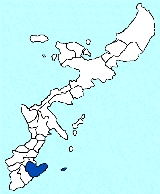
Nanjo, Okinawa
Encyclopedia
Municipalities of Japan
Japan has three levels of government: national, prefectural, and municipal. The nation is divided into 47 prefectures. Each prefecture consists of numerous municipalities. There are four types of municipalities in Japan: cities, towns, villages and special wards...
in the southern part of Okinawa Island
Okinawa Island
Okinawa Island is the largest of the Okinawa Islands and the Ryukyu Islands of Japan, and is home to Naha, the capital of Okinawa Prefecture. The island has an area of...
in Okinawa Prefecture
Okinawa Prefecture
is one of Japan's southern prefectures. It consists of hundreds of the Ryukyu Islands in a chain over long, which extends southwest from Kyūshū to Taiwan. Okinawa's capital, Naha, is located in the southern part of Okinawa Island...
, Japan
Japan
Japan is an island nation in East Asia. Located in the Pacific Ocean, it lies to the east of the Sea of Japan, China, North Korea, South Korea and Russia, stretching from the Sea of Okhotsk in the north to the East China Sea and Taiwan in the south...
.
It was formed on January 1, 2006, from the merger of the town of Sashiki
Sashiki, Okinawa
was a town located in Shimajiri District, Okinawa, Japan.On January 1, 2006 Sashiki was merged with the villages of Chinen, Ōzato and Tamagusuku, all from Shimajiri District, to form the new city of Nanjō....
, and the villages of Chinen
Chinen, Okinawa
was a village located in Shimajiri District, Okinawa, Japan.On January 1, 2006, Chinen was merged with the town of Sashiki, and the villages of Ōzato and Tamagusuku, all from Shimajiri District, to form the new city of Nanjō....
, Ōzato
Ozato, Okinawa
was a village located in Shimajiri District, Okinawa, Japan.On January 1, 2006 Ōzato was merged with the town of Sashiki, and the villages of Chinen and Tamagusuku, all from Shimajiri District, to form the new city of Nanjō....
and Tamagusuku
Tamagusuku, Okinawa
was a village located in Shimajiri District, Okinawa, Japan.On January 1, 2006 Tamagusuku was merged with the town of Sashiki, and the villages of Chinen and Ōzato, all from Shimajiri District, to form the new city of Nanjō....
, all from Shimajiri District
Shimajiri District, Okinawa
is a district located in Okinawa, Japan. Roughly translated, Shimajiri means "Butt of the island" which refers to its southerly position on the island of Okinawa. Compare this to Kunigami District, Okinawa....
.
Nanjō has an area of 49.69 km² and, as of the date of its inception, a population of 40,759, and a population density of 820.3 per km².
Translated literally, the name Nanjō means something like "the city of the southern castle". Many castle ruins, called gusuku
Gusuku
, or just , is the term used for the distinctive Okinawan form of castles or fortresses. In standard Japanese, the same kanji is pronounced "shiro", but the word is probably cognate with a different Japanese word, "soko" , which means "fortress"...
in the Okinawan language
Okinawan language
Central Okinawan, or simply Okinawan , is a Northern Ryukyuan language spoken primarily in the southern half of the island of Okinawa, as well as in the surrounding islands of Kerama, Kumejima, Tonaki, Aguni, and a number of smaller peripheral islands...
, can be found throughout the city.
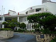
Of the eleven cities in Okinawa Prefecture, Nanjō has the smallest population. It does not have a separate police station nor a high school. For those services, citizens have to refer to the neighbouring towns of Yonabaru and Yaese. The city hosts a fire station responsible for Chinen, Ōzato and Tamagusuku and parts of Yaese, while Sashiki is served by a separate station.
The city's main economical activities are agriculture and tourism. Important crops include sugarcane
Sugarcane
Sugarcane refers to any of six to 37 species of tall perennial grasses of the genus Saccharum . Native to the warm temperate to tropical regions of South Asia, they have stout, jointed, fibrous stalks that are rich in sugar, and measure two to six metres tall...
, for sugar
Sugar
Sugar is a class of edible crystalline carbohydrates, mainly sucrose, lactose, and fructose, characterized by a sweet flavor.Sucrose in its refined form primarily comes from sugar cane and sugar beet...
and vinegar
Vinegar
Vinegar is a liquid substance consisting mainly of acetic acid and water, the acetic acid being produced through the fermentation of ethanol by acetic acid bacteria. Commercial vinegar is produced either by fast or slow fermentation processes. Slow methods generally are used with traditional...
production, and turmeric
Turmeric
Turmeric is a rhizomatous herbaceous perennial plant of the ginger family, Zingiberaceae. It is native to tropical South Asia and needs temperatures between 20 °C and 30 °C and a considerable amount of annual rainfall to thrive...
, a popular medicinal herb in Okinawa. Several turmeric processing plants are based in the city, producing semi-processed goods to be used by industries on the mainland or consumer products like tea
Tea
Tea is an aromatic beverage prepared by adding cured leaves of the Camellia sinensis plant to hot water. The term also refers to the plant itself. After water, tea is the most widely consumed beverage in the world...
and dietary supplements.
Geography
Nanjō is a city located in the southern region (南部 - Nanbu) of Okinawa's main island. The isle of Kudaka, off the coast of Chinen, also belongs to the city.Districts
- Chinen (知念)
- Azama (安座真)
- Umino (海野)
- Gushiken (具志堅)
- Kudaka (久高)
- Kudeken (久手堅)
- Kuhara (久原)
- Shikiya (志喜屋)
- China (知名)
- Chinen (知念)
- Yamazato (山里)
- Yoshitomi (吉富)
- Ōzato (大里)
- Furugen (古堅)
- Inamine (稲嶺)
- Minei (嶺井)
- Nakama (仲間))
- Ōzato (大里)
- Ōshiro (大城)
- Takahira (高平)
- Sashiki (佐敷)
- Fusozaki (富祖崎)
- Ibara (伊原)
- Kaneku (兼久)
- Nakaiho (仲伊保)
- Okoku (小谷)
- Sashiki (佐敷)
- Shinkai (新開)
- Shinzato (新里)
- Tedokon (手登根)
- Tsuhako (津波古)
- Yabiku (屋比久)
- Tamagusuku (玉城)
- Aichi (愛地)
- Funakosi (船越)
- Fusato (富里)
- Horikawa (堀川)
- Hyakuna (百名)
- Itokazu (糸数)
- Kakinohana (垣花)
- Kibaru (喜良原)
- Maekawa (前川)
- Nakayama (中山)
- Nakandakari (仲村渠)
- Ō (奥武)
- Oyakebaru (親慶原)
- Shikenbaru (志堅原)
- Tamagusuku (玉城)
- Tōyama (當山)
- Yakabu (屋嘉部)
Surrounding Municipalities
- YonabaruYonabaru, Okinawais a town located in Shimajiri District, Okinawa, Japan.As of 2008, the town has an estimated population of 15,405 and a density of 3,069 persons per km². The total area is 5.02 km², making it the second smallest municipality in Okinawa....
- YaeseYaese, Okinawais a town in Shimajiri District, Okinawa, Japan.Yaese was formed on January 1, 2006 by a merger between the town of Kochinda and the village of Gushikami . As of February 2008, Yaese has a population of 26,758 ....
- HaebaruHaebaru, Okinawais a town located in Shimajiri District, Okinawa, Japan.As of 2005, the town has an estimated population of 34,020 and a density of 3174 persons per km². The total area is 10.72 km²...
Tourism and Culture
Seifa-utaki
, meaning "purified place of Utaki," is a Shinto Shrine. It is part of the UNESCO World Heritage Site Gusuku Sites and Related Properties of the Kingdom of Ryukyu in Nanjō, Okinawa....
(斎場御嶽) shrine is listed by UNESCO
UNESCO
The United Nations Educational, Scientific and Cultural Organization is a specialized agency of the United Nations...
as part of the Gusuku Sites and Related Properties of the Kingdom of Ryukyu
Gusuku Sites and Related Properties of the Kingdom of Ryukyu
The Gusuku Sites and Related Properties of the Kingdom of Ryukyu is an UNESCO World Heritage Site which consists of nine sites all located in Okinawa Prefecture, Japan. The heritage sites include two groves or utaki, the mausoleum Tamaudun, one garden, and five gusuku castles sites, most of which...
World Heritage Site
World Heritage Site
A UNESCO World Heritage Site is a place that is listed by the UNESCO as of special cultural or physical significance...
. It was believed to be a sacred place, from where one could see the "Isle of the Gods". In the shrine, noro
Noro
Noro is a town in the Solomon Islands, in the Western Province. It has about 5000 inhabitants. It has a cannery, which was owned by Taiyo Fisheries until 2001 and is now run by the Solomon Islands government....
priestesses from Shuri Castle
Shuri Castle
Shuri Castle is a gusuku in Shuri, Okinawa. It was the palace of the Ryūkyū Kingdom. In 1945, during the Battle of Okinawa, it was almost completely destroyed...
would pray for the well-being of the king and the kingdom.
In Tamagusuku, the Gyokusendō cave
Cave
A cave or cavern is a natural underground space large enough for a human to enter. The term applies to natural cavities some part of which is in total darkness. The word cave also includes smaller spaces like rock shelters, sea caves, and grottos.Speleology is the science of exploration and study...
with a total length of five kilometers is known for its beautiful stalagmite
Stalagmite
A stalagmite is a type of speleothem that rises from the floor of a limestone cave due to the dripping of mineralized solutions and the deposition of calcium carbonate. This stalagmite formation occurs only under certain pH conditions within the underground cavern. The corresponding formation on...
s and stalactite
Stalactite
A stalactite , "to drip", and meaning "that which drips") is a type of speleothem that hangs from the ceiling of limestone caves. It is a type of dripstone...
s. 850 metres of these caves are open to tourists. The cave is located inside a theme park, named Okinawa World. Other attractions of the theme park are native dances such as Eisa
Eisa
Eisa or EISA can have several meanings:* Eisa:** A daughter of the god Fornjót in Norse mythology** A dance in Okinawa Prefecture, Japan** Tell el-Eisa Hill, near El Alamein in Egypt, site of a cemetery for those who died in the battles.* EISA:...
, a traditional Ryūkyū-style village and a Habu
Habu
' is a Japanese name used to refer to certain venomous snakes:Snakes:* The following species are found in the Ryukyu Islands of Japan:** Trimeresurus elegans, a.k.a. the Sakishima habu, found in the southern Ryukyu Islands...
snake zoo.
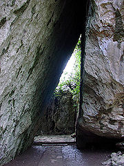
Also located in Tamagusku, the Itokazu-Abuchiragama cave was used in World War II
World War II
World War II, or the Second World War , was a global conflict lasting from 1939 to 1945, involving most of the world's nations—including all of the great powers—eventually forming two opposing military alliances: the Allies and the Axis...
as a bomb shelter by soldiers and civilians alike. It is also open to tourists. Himeyuri Students
Himeyuri Students
The ', sometimes called "Lily Corps" in English, was a group of female high school students and teachers formed into a nursing unit for the Imperial Japanese Army during the Battle of Okinawa in 1945. 222 students and 18 teachers of the former Okinawa Daiichi Women's High School and Okinawa Shihan...
were used as nurses in this location among others.
The isle of Kudaka, also called Isle of the Gods, can be accessed from Azama Port, located in Chinen.
From the isle of Ōjima, in Tamagusuku, one can board a "Glass boat", a boat with a transparent floor used in marine-life observations.
As golf
Golf
Golf is a precision club and ball sport, in which competing players use many types of clubs to hit balls into a series of holes on a golf course using the fewest number of strokes....
is a popular sport in Okinawa, a famous site in Nanjō is the Ryūkyū Golf Club, with three 27-hole courses. Every spring, the Ryūkyū Golf Club welcomes the Daikin Orchid Ladies Golf Tournament.
Historical Facts
Shō HashiSho Hashi
Shō Hashi was the first king of the Ryūkyū Kingdom , uniting the three kingdoms of Chūzan, Hokuzan, and Nanzan by conquest...
was the leader of Sashiki-gusuku before uniting the Ryūkyū Kingdom
Ryukyu Kingdom
The Ryūkyū Kingdom was an independent kingdom which ruled most of the Ryukyu Islands from the 15th century to the 19th century. The Kings of Ryūkyū unified Okinawa Island and extended the kingdom to the Amami Islands in modern-day Kagoshima Prefecture, and the Sakishima Islands near Taiwan...
.
- 1908 (Meiji Era, year 41) One year after Okinawa Prefecture is established by an Imperial Edict, the MagiriMagiriwas a historical type of administrative district in Okinawa, Japan. In concept they were similar to present day Japanese prefectures, but in size they were closer to cities, towns and villages....
system is abolished and the villages of Chinen, Ōzato, Sashiki and Tamagusuku are created. - 1945 (Showa Era, year 20) After the Battle of OkinawaBattle of OkinawaThe Battle of Okinawa, codenamed Operation Iceberg, was fought on the Ryukyu Islands of Okinawa and was the largest amphibious assault in the Pacific War of World War II. The 82-day-long battle lasted from early April until mid-June 1945...
, Chinen is given the status of cityCityA city is a relatively large and permanent settlement. Although there is no agreement on how a city is distinguished from a town within general English language meanings, many cities have a particular administrative, legal, or historical status based on local law.For example, in the U.S...
by the occuping American Army. In the following year, it reverts to being a villageVillageA village is a clustered human settlement or community, larger than a hamlet with the population ranging from a few hundred to a few thousand , Though often located in rural areas, the term urban village is also applied to certain urban neighbourhoods, such as the West Village in Manhattan, New...
. - 1949 (Showa Era, year 24) The districts (字) of Yonabaru, Ueyonabaru and Itarashiki are severed from the village of Ōzato to form the new village of Yonabaru.
- 1980 (Showa Era, year 55) Sashiki receives the status of town.
- 2005 (Heisei Era, year 17), March The name Nanjō-shi was selected for the soon to be founded city.
- 2006 (Heisei Era, year 18), January 1 Foundation of the city of Nanjō.
Sister Town
TamakiTamaki, Mie
is a town located in Watarai District, Mie, Japan.As of 2010, the town has an estimated population of 15,268 and a density of 373 persons per km². The total area is 40.94 km²....
, Mie Prefecture
Mie Prefecture
is a prefecture of Japan which is part of the Kansai regions on Honshū island. The capital is the city of Tsu.- History :Until the Meiji Restoration, Mie prefecture was known as Ise Province and Iga Province....
since 1993 (domestic)
In kanji
Kanji
Kanji are the adopted logographic Chinese characters hanzi that are used in the modern Japanese writing system along with hiragana , katakana , Indo Arabic numerals, and the occasional use of the Latin alphabet...
, Tamaki has the same spelling as Tamagusuku
Tamagusuku
was a king of the Ryūkyū Islands.Tamgusuku was a "king" of the Okinawan kingdom of Chūzan from roughly 1314-1336.He was the third son of Eiji , he was the fourth ruler of the lineage of Eiso was a king of the Ryūkyū Islands.Tamgusuku was a "king" of the Okinawan kingdom of Chūzan from roughly...
(玉城). Neither name follows the standard readings for the kanji in Japanese
Japanese language
is a language spoken by over 130 million people in Japan and in Japanese emigrant communities. It is a member of the Japonic language family, which has a number of proposed relationships with other languages, none of which has gained wide acceptance among historical linguists .Japanese is an...
.
By bus
Several lines serve the city of Nanjo, departing from the bus terminals at Naha and Itoman.External links
Nanjo City home page Gyokusendo - Okinawa World Wel Sunpia Ryukyu Golf Club----