

Namonuito Atoll
Encyclopedia
Namonuito Atoll, also called Namonweito, Weito, or Magur Islands, is the largest atoll
of the Federated States of Micronesia
and of the Caroline Islands
, with a total area of 2267 km², unless one considers the still larger Truk Lagoon
as a type of atoll in an early stage of development. In Micronesia
, only Kwajalein
Atoll of the Marshall Islands
is larger.
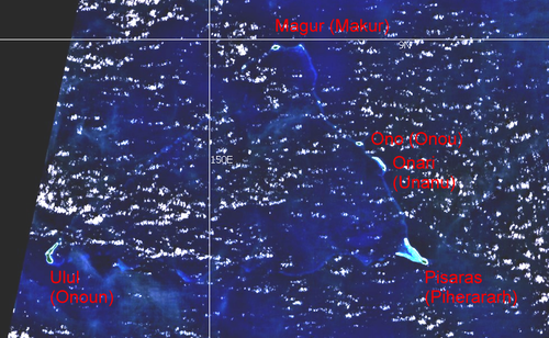
Namonuito Atoll lies in the northwestern region (Oksoritod) of Chuuk
State, the largest federal State of the Federated States of Micronesia, about 170 km northeast of Truk Lagoon (measured from Pisaras Islet to the northern and western parts of the fringing reef of Truk Lagoon). It is roughly triangular in shape, with the base running 82 km along its southern side. The southwest corner of the triangle is marked by Ulul
islet, the main island (largest and most populated), also called Onoun. The other islets lie mostly on the northeast side, from Pisaras
islet in the southeast corner to Magur (Makur) islet in the north corner. The 12 islets have an aggregate land area of only 4.5 km². The total population is 1.341 (census
of 2000).
The reef rim of the atoll is submerged for the greater part and is marked by the lighter color of the water over it. The depths on the reef range from 0.9 to 18.3 meters. The reef appears to be in the process of formation and can be crossed at many places. The lagoon is not of uniform depth. Except for a 5.5 meter patch, located 22 km west of Pisaras island, and a detached reef, with depths of 2.7 to 3.7 meters, located about 10 km of Pisaras, there appears to be no less than 9 meters on the scattered coral heads.
Pisaras Island has coconut palms and other trees growing on it. Reefs extend northwest and WNW from the island, enclosing a shallow and foul bay. Ulul Island is densely covered with coconut
palms. A drying reef fringes the island. There is a radio station on the island.
The atoll is home to five of the 40 municipalities
of Chuuk state, listed in counterclockwise sequence, with population (2000):
Atoll
An atoll is a coral island that encircles a lagoon partially or completely.- Usage :The word atoll comes from the Dhivehi word atholhu OED...
of the Federated States of Micronesia
Federated States of Micronesia
The Federated States of Micronesia or FSM is an independent, sovereign island nation, made up of four states from west to east: Yap, Chuuk, Pohnpei and Kosrae. It comprises approximately 607 islands with c...
and of the Caroline Islands
Caroline Islands
The Caroline Islands are a widely scattered archipelago of tiny islands in the western Pacific Ocean, to the north of New Guinea. Politically they are divided between the Federated States of Micronesia in the eastern part of the group, and Palau at the extreme western end...
, with a total area of 2267 km², unless one considers the still larger Truk Lagoon
Truk Lagoon
Truk Lagoon, also known as Chuuk, is a sheltered body of water in the central Pacific. North of New Guinea, it is located mid-ocean at 7 degrees North latitude. The atoll consists of a protective reef, around, enclosing a natural harbour 79 by 50 kilometres , with an area of . It has a land...
as a type of atoll in an early stage of development. In Micronesia
Micronesia
Micronesia is a subregion of Oceania, comprising thousands of small islands in the western Pacific Ocean. It is distinct from Melanesia to the south, and Polynesia to the east. The Philippines lie to the west, and Indonesia to the southwest....
, only Kwajalein
Kwajalein
Kwajalein Atoll , is part of the Republic of the Marshall Islands . The southernmost and largest island in the atoll is named Kwajalein Island. English-speaking residents of the U.S...
Atoll of the Marshall Islands
Marshall Islands
The Republic of the Marshall Islands , , is a Micronesian nation of atolls and islands in the middle of the Pacific Ocean, just west of the International Date Line and just north of the Equator. As of July 2011 the population was 67,182...
is larger.
Namonuito Atoll lies in the northwestern region (Oksoritod) of Chuuk
Chuuk
Chuuk — formerly Truk, Ruk, Hogoleu, Torres, Ugulat, and Lugulus — is an island group in the south western part of the Pacific Ocean. It comprises one of the four states of the Federated States of Micronesia , along with Kosrae, Pohnpei, and Yap. Chuuk is the most populous of the FSM's...
State, the largest federal State of the Federated States of Micronesia, about 170 km northeast of Truk Lagoon (measured from Pisaras Islet to the northern and western parts of the fringing reef of Truk Lagoon). It is roughly triangular in shape, with the base running 82 km along its southern side. The southwest corner of the triangle is marked by Ulul
Ulul
Ulul is a village and municipality in the state of Chuuk, Federated States of Micronesia.-Reference:*, retrieved December 8, 2010...
islet, the main island (largest and most populated), also called Onoun. The other islets lie mostly on the northeast side, from Pisaras
Pisaras
Pisaras is a village and municipality in the state of Chuuk, Federated States of Micronesia.-Reference:*, retrieved December 8, 2010...
islet in the southeast corner to Magur (Makur) islet in the north corner. The 12 islets have an aggregate land area of only 4.5 km². The total population is 1.341 (census
Census
A census is the procedure of systematically acquiring and recording information about the members of a given population. It is a regularly occurring and official count of a particular population. The term is used mostly in connection with national population and housing censuses; other common...
of 2000).
The reef rim of the atoll is submerged for the greater part and is marked by the lighter color of the water over it. The depths on the reef range from 0.9 to 18.3 meters. The reef appears to be in the process of formation and can be crossed at many places. The lagoon is not of uniform depth. Except for a 5.5 meter patch, located 22 km west of Pisaras island, and a detached reef, with depths of 2.7 to 3.7 meters, located about 10 km of Pisaras, there appears to be no less than 9 meters on the scattered coral heads.
Pisaras Island has coconut palms and other trees growing on it. Reefs extend northwest and WNW from the island, enclosing a shallow and foul bay. Ulul Island is densely covered with coconut
palms. A drying reef fringes the island. There is a radio station on the island.
The atoll is home to five of the 40 municipalities
Municipality
A municipality is essentially an urban administrative division having corporate status and usually powers of self-government. It can also be used to mean the governing body of a municipality. A municipality is a general-purpose administrative subdivision, as opposed to a special-purpose district...
of Chuuk state, listed in counterclockwise sequence, with population (2000):
 Landsat visible color image Landsat visible color image |
||||||||
| Municipality Municipality A municipality is essentially an urban administrative division having corporate status and usually powers of self-government. It can also be used to mean the governing body of a municipality. A municipality is a general-purpose administrative subdivision, as opposed to a special-purpose district... |
alternateor formername | Landareakm² | Population(census Census A census is the procedure of systematically acquiring and recording information about the members of a given population. It is a regularly occurring and official count of a particular population. The term is used mostly in connection with national population and housing censuses; other common... 2000) |
location | islands | coordinates | ||
|---|---|---|---|---|---|---|---|---|
| Onoun | Ulul | 2.54 | 598 | southwest corner | Ulul Island | 08°35′22"N 149°39′37"E | ||
| Piherararh |
Pisaras |
0.80 |
227 |
southeast corner |
Wabonoru IsletPisaras IslandPielimal IsletWeltot Islet | 08°35′50"N 150°21′18"E08°34′55"N 150°24′26"E08°36′50"N 150°22′38"E08°37′15"N 150°22′16"E | ||
| Unanu |
Onari |
0.26 |
178 |
northeast rim |
Onari IslandBihof IsletBehiliper IsletAmurtride Islet | 08°45′11"N 150°19′46"E08°45′43"N 150°19′24"E08°46′03"N 150°19′02"E08°46′10"N 150°18′47"E | ||
| Onou | Ono | 0.31 | 182 | northeast rim | Ono Island | 08°47′52"N 150°16′58"E | ||
| Makur |
Magur Islands |
0.47 |
156 |
north corner |
Magur IslandMagererik Islet | 08°59′27"N 150°07′22"E08°57′24"N 150°03′53"E | ||
| Namonuito Atoll | Magur Islands | 4.38 | 1,341 | 08°40′00"N 150°00′00"E | ||||
External links
- http://permanent.access.gpo.gov/websites/pollux/pollux.nss.nima.mil/NAV_PUBS/SD/pub126/126sec10.pdfSailing DirectionsSailing DirectionsSailing Directions is a 42-volume American navigation publication published by the National Geospatial-Intelligence Agency . Sailing Directions consists of 37 Enroute volumes, 4 Planning Guide volumes, and 1 volume combining both types...
(enroute), page 263] - exact islet coordinates
- historic census data, population densities