

Målselv
Encyclopedia
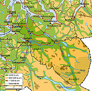
Målselv is a municipality
in Troms
county
, Norway
. The administrative centre of the municipality is the village of Moen
. Some other villages include Andslimoen
, Bardufoss
, Alappmoen
, Holmen, Fossmoen
, and Heggelia
. Besides bordering Sweden
to the east and the ocean (Malangen
fjord) to the west, it borders on the municipalities of Balsfjord
, Storfjord
, Bardu
, Sørreisa
, and Lenvik
.
 Maalselven was established in 1849 when it was separated from the municipality of Lenviken. The initial population of Maalselven was 2,616. In 1891, some parts of the Målsnes area (population: 30) were transferred to neighboring Malangen. On 1 January 1904, an area with 5 inhabitants was transferred from Balsfjord to Maalselven. The spelling of the name was changed to Målselv in 1918. On 1 July 1925, the district of Øverbygd
was separated from Målselv to form a new municipality of its own. This left Målselv with 3,531 residents.
On 1 January 1964, the municipality of Øverbygd (population: 1,232), municipality of Målselv (population: 5,584), the Naveren and Målsnes areas of Malangen (population: 118), and the Skogli ved Heia farm in Balsfjord (population: 2) were all merged together to form a new, larger municipality of Målselv with a new population of 6,936. On 1 January 1966, the Sørelvmo area (population: 131) was transferred from Balsfjord to Målselv. Then on 1 January 1972, the Blomli i Fagerfjell area of Målselv (population: 63) was transferred to Lenvik.
. The first element is the genitive case
of the old uncompounded name of the Malangen fjord
: Malr and the last element is the finite form of elv which means "river
". The old name of the fjord is identical with the word malr which means "bag" or "sack" (referring to the shape of the fjord). Prior to 1918, the name was written "Maalselven".
is from modern times. They were granted on 1 February 1985. The arms are a canting
that represent the Målselva river which runs through the municipality.
from 1788 and onwards. They were attracted by the uninhabited land with vast forest
s and areas of fertile land in the broad Målselvdalen
. The valley and municipality take their name from the river Målselva. The river is well known for its salmon
, and forms the Målselv waterfall , which has been selected as Norway's national waterfall
. The Målselva empties into the Malangen fjord north of Olsborg. There are several mountains in the municipality: Njunis
(1713 metres (5,620.1 ft)) is the highest and Istind is popular among hikers. There are many lakes such as Andsvatnet, Finnfjordvatnet, Rostajavri, Lille Rostavatn
, and Takvatnet. One of the rarest orchids in Europe
, Lysiella oligantha , is found in Målselv. Øvre Dividal National Park
(740 square kilometres (285.7 sq mi)) is located in the easternmost part of Målselv, near the border with Sweden.
and only 282 millimetres (11.1 in) in the Divi valley, which sits at 282 m (925.2 ft) above sea level. April through June is the driest period.
, Nye Troms, covering Målselv, Bardu, and Balsfjord, has its main office in the Olsborg area. The municipality administration is located at Moen, about 2 kilometres (1.2 mi) east of Olsborg. Further south along European route E6
is the Bardufoss region, which encompasses the local communities Andselv
and Heggelia
, the latter including the Norwegian army
's 6th division. Near Andselv is the Bardufoss Airport
and the Bardufoss Air Station
of the Royal Norwegian Air Force
, including the 337th and 339th Air Force helicopter squadrons. Målselv municipality, together with neighbouring Bardu, has the largest concentration of army bases in the country.
Moving further up the valley, another local community is Rundhaug, and moving eastwards, closer to Øvre Dividal National Park, is the community of Øverbygd, housing two more sub-communities Skjold
and Holt. The former also houses the Skjold base
for mechanized infantry
and combat engineers
.
Tourism is a growing industry in Målselv, with the opening of Målselv Fjellandsby, an alpine ski destination. Målselv is also home to Målselvfossen, Norway's national waterfall and a mecca for salmon fishermen. Bardufoss concentration camp
was located here during World War II
.
Municipalities of Norway
Norway is divided into 19 administrative regions, called counties , and 430 municipalities...
in Troms
Troms
or Romsa is a county in North Norway, bordering Finnmark to the northeast and Nordland in the southwest. To the south is Norrbotten Län in Sweden and further southeast is a shorter border with Lapland Province in Finland. To the west is the Norwegian Sea...
county
Counties of Norway
Norway is divided into 19 administrative regions, called counties . The counties form the primary first-level subdivisions of Norway and are further divided into 430 municipalities...
, Norway
Norway
Norway , officially the Kingdom of Norway, is a Nordic unitary constitutional monarchy whose territory comprises the western portion of the Scandinavian Peninsula, Jan Mayen, and the Arctic archipelago of Svalbard and Bouvet Island. Norway has a total area of and a population of about 4.9 million...
. The administrative centre of the municipality is the village of Moen
Moen, Troms
Moen is a village area and administrative centre of the municipality of Målselv in Troms county, Norway. The population is 838. Moen is located in the Målselvdalen valley about north of the village of Andselv and Bardufoss Airport....
. Some other villages include Andslimoen
Andslimoen
Andslimoen is a village along the river Målselva in the Målselvdalen valley in the western part of the municipality of Målselv, in Troms county, Norway. Its population is 533. The village is located along European route E6, about north of the village of Andselv and about south of the village of...
, Bardufoss
Bardufoss
Bardufoss is a small village in the municipality of Målselv in Troms county, Norway. The population was 2,580. Bardufoss is located in the Målselvdalen valley near the confluence of the Barduelva and Målselva rivers. It is located about north of the city of Narvik and about south of the city...
, Alappmoen
Alappmoen
Alappmoen is a small farming village located near the Målselva river in the municipality of Målselv in Troms county, Norway. It is about southeast of Bardufoss and southwest of Skjold....
, Holmen, Fossmoen
Fossmoen
Fossmoen is a small village in the Bardufoss area of the municipality of Målselv in Troms county, Norway. It is located about southeast of Bardufoss Airport and the village of Andselv. The village is named after the nearby waterfall Bardufossen. The population of Fossmoen was 147...
, and Heggelia
Heggelia
Heggelia is a village along the Barduelva in the Bardufoss area in Troms county, Norway. Most of the village is located in the municipality of Målselv, but of it is located over the border in the municipality of Bardu. The village population is 928, with 10 of those people living in Bardu...
. Besides bordering Sweden
Sweden
Sweden , officially the Kingdom of Sweden , is a Nordic country on the Scandinavian Peninsula in Northern Europe. Sweden borders with Norway and Finland and is connected to Denmark by a bridge-tunnel across the Öresund....
to the east and the ocean (Malangen
Malangen
Malangen is a fjord and a former municipality in Troms county in Norway. The fjord is located between the islands of Kvaløya and Senja and the area today is divided between the municipalities of Balsfjord, Lenvik, Tromsø, and Målselv...
fjord) to the west, it borders on the municipalities of Balsfjord
Balsfjord
Balsfjord is a municipality in Troms county, Norway. The administrative centre of the municipality is the village of Storsteinnes, while Nordkjosbotn at the head of the fjord is another village....
, Storfjord
Storfjord
Storfjord is a municipality in Troms county, Norway. The administrative centre of the municipality is the village of Hatteng.- General information :...
, Bardu
Bardu
Bardu is a municipality in Troms county, Norway. The administrative centre of the municipality is the village of Setermoen, the largest urban area in the municipality.Norway's largest military garrison is located at Setermoen...
, Sørreisa
Sørreisa
Sørreisa is a municipality in Troms county, Norway. The administrative centre of the municipality is the village of Sørreisa.- General information :...
, and Lenvik
Lenvik
Lenvik is a municipality in Troms county, Norway. The municipality is partly situated on the mainland, partly on the island of Senja. The administrative center is the town of Finnsnes, where the Gisund Bridge connects Senja to the mainland by road. Other settlements include Aglapsvik, Gibostad,...
.
General information
Øverbygd
Øverbygd is a former municipality in Troms county in Norway. It is located in the present-day municipality of Målselv from the Lille Rostavatn lake along the Målselva river through the Målselvdalen valley. The village of Skjold is home to a large garrison for the Norwegian Army...
was separated from Målselv to form a new municipality of its own. This left Målselv with 3,531 residents.
On 1 January 1964, the municipality of Øverbygd (population: 1,232), municipality of Målselv (population: 5,584), the Naveren and Målsnes areas of Malangen (population: 118), and the Skogli ved Heia farm in Balsfjord (population: 2) were all merged together to form a new, larger municipality of Målselv with a new population of 6,936. On 1 January 1966, the Sørelvmo area (population: 131) was transferred from Balsfjord to Målselv. Then on 1 January 1972, the Blomli i Fagerfjell area of Målselv (population: 63) was transferred to Lenvik.
Name
The municipality is named after the river MålselvaMålselva
The Målselva river in Troms county, Norway has given name to Målselv municipality and the Målselvdalen valley. The river empties into the in Målselvfjorden, an arm of the Malangen fjord, north of Olsborg. The rivers Divielva, Tamokelva, and Rostaelva converge near the Lille Rostavatn lake to form...
. The first element is the genitive case
Genitive case
In grammar, genitive is the grammatical case that marks a noun as modifying another noun...
of the old uncompounded name of the Malangen fjord
Fjord
Geologically, a fjord is a long, narrow inlet with steep sides or cliffs, created in a valley carved by glacial activity.-Formation:A fjord is formed when a glacier cuts a U-shaped valley by abrasion of the surrounding bedrock. Glacial melting is accompanied by rebound of Earth's crust as the ice...
: Malr and the last element is the finite form of elv which means "river
River
A river is a natural watercourse, usually freshwater, flowing towards an ocean, a lake, a sea, or another river. In a few cases, a river simply flows into the ground or dries up completely before reaching another body of water. Small rivers may also be called by several other names, including...
". The old name of the fjord is identical with the word malr which means "bag" or "sack" (referring to the shape of the fjord). Prior to 1918, the name was written "Maalselven".
Coat-of-arms
The coat-of-armsCoat of arms
A coat of arms is a unique heraldic design on a shield or escutcheon or on a surcoat or tabard used to cover and protect armour and to identify the wearer. Thus the term is often stated as "coat-armour", because it was anciently displayed on the front of a coat of cloth...
is from modern times. They were granted on 1 February 1985. The arms are a canting
Canting arms
Canting arms are heraldic bearings that represent the bearer's name in a visual pun or rebus. The term cant came into the English language from Anglo-Norman cant, meaning song or singing, from Latin cantāre, and English cognates include canticle, chant, accent, incantation and recant.Canting arms –...
that represent the Målselva river which runs through the municipality.
Geography
Målselv was settled by farmers from southern Norway, especially ØsterdalenØsterdalen
Østerdalen is a valley and traditional district in Hedmark County, in Eastern Norway. It consisting of the municipalities Rendalen, Alvdal, Folldal,Tynset, Tolga and Os in the north, Elverum, Stor-Elvdal, Engerdal, Trysil and Åmot in the south.-Geography:...
from 1788 and onwards. They were attracted by the uninhabited land with vast forest
Forest
A forest, also referred to as a wood or the woods, is an area with a high density of trees. As with cities, depending where you are in the world, what is considered a forest may vary significantly in size and have various classification according to how and what of the forest is composed...
s and areas of fertile land in the broad Målselvdalen
Målselvdalen
Målselvdalen is the largest valley in Troms county, Norway. The river Målselva runs through the valley, ending in the Målselvfjorden. With a landscape reminiscent of that of Østerdalen, the valley was settled in the late eighteenth century by farmers from Østerdalen and Gudbrandsdalen. The bailiff...
. The valley and municipality take their name from the river Målselva. The river is well known for its salmon
Salmon
Salmon is the common name for several species of fish in the family Salmonidae. Several other fish in the same family are called trout; the difference is often said to be that salmon migrate and trout are resident, but this distinction does not strictly hold true...
, and forms the Målselv waterfall , which has been selected as Norway's national waterfall
Waterfall
A waterfall is a place where flowing water rapidly drops in elevation as it flows over a steep region or a cliff.-Formation:Waterfalls are commonly formed when a river is young. At these times the channel is often narrow and deep. When the river courses over resistant bedrock, erosion happens...
. The Målselva empties into the Malangen fjord north of Olsborg. There are several mountains in the municipality: Njunis
Njunis
Njunis is a mountain in the interior of southern Troms county, in Målselv municipality. With a peak at , it is the highest mountain in this part of the county, and has Norway's thirteenth largest prominence. The tree line reaches to elevation on the southern slope of the mountain, the highest...
(1713 metres (5,620.1 ft)) is the highest and Istind is popular among hikers. There are many lakes such as Andsvatnet, Finnfjordvatnet, Rostajavri, Lille Rostavatn
Lille Rostavatn
Lille Rostavatn is a lake in the municipality of Målselv in Troms county, Norway. It is part of the Rostaelva river system which empties into the great Målselva river. It is located about east of the village of Skjold....
, and Takvatnet. One of the rarest orchids in Europe
Europe
Europe is, by convention, one of the world's seven continents. Comprising the westernmost peninsula of Eurasia, Europe is generally 'divided' from Asia to its east by the watershed divides of the Ural and Caucasus Mountains, the Ural River, the Caspian and Black Seas, and the waterways connecting...
, Lysiella oligantha , is found in Målselv. Øvre Dividal National Park
Øvre Dividal National Park
Øvre Dividal National Park lies in Målselv in Troms county, Norway. The park was opened in 1971 and has an area of . The original intention was to preserve a very little disturbed inland valley and mountain area. The hiking trail Nordkalottruta passes through the national park.-Name:The first...
(740 square kilometres (285.7 sq mi)) is located in the easternmost part of Målselv, near the border with Sweden.
Climate
Målselv is fairly sheltered from the coastal weather, and has a somewhat inland climate. Mean annual precipitation is 745 millimetres (29.3 in) at Moen, 652 millimetres (25.7 in) at BardufossBardufoss
Bardufoss is a small village in the municipality of Målselv in Troms county, Norway. The population was 2,580. Bardufoss is located in the Målselvdalen valley near the confluence of the Barduelva and Målselva rivers. It is located about north of the city of Narvik and about south of the city...
and only 282 millimetres (11.1 in) in the Divi valley, which sits at 282 m (925.2 ft) above sea level. April through June is the driest period.
Economy
A local newspaperNewspaper
A newspaper is a scheduled publication containing news of current events, informative articles, diverse features and advertising. It usually is printed on relatively inexpensive, low-grade paper such as newsprint. By 2007, there were 6580 daily newspapers in the world selling 395 million copies a...
, Nye Troms, covering Målselv, Bardu, and Balsfjord, has its main office in the Olsborg area. The municipality administration is located at Moen, about 2 kilometres (1.2 mi) east of Olsborg. Further south along European route E6
European route E6
European route E 6 is the designation for the main north-south road in Norway, and the west coast of Sweden, running from the southern tip of Sweden, at Trelleborg, into Norway and through almost all of the country north to Finnmark. The route ends close to the Norwegian border with Russia...
is the Bardufoss region, which encompasses the local communities Andselv
Andselv
Andselv is a village along the Andselva river in the Bardufoss area in the municipality of Målselv, in Troms county, Norway. Its population is 776. Andselv is located just north of Bardufoss Airport along European route E6 about north of the village of Heggelia and south of Andslimoen....
and Heggelia
Heggelia
Heggelia is a village along the Barduelva in the Bardufoss area in Troms county, Norway. Most of the village is located in the municipality of Målselv, but of it is located over the border in the municipality of Bardu. The village population is 928, with 10 of those people living in Bardu...
, the latter including the Norwegian army
Norwegian Army
Norway achieved full independence in 1905, and in the first century of its short life has contributed to two major conflicts, the Cold War and the War on Terror. The Norwegian Army currently operates in the north of Norway and in Afghanistan as well as in Eastern Europe. The Army is the oldest of...
's 6th division. Near Andselv is the Bardufoss Airport
Bardufoss Airport
Bardufoss Airport is situated at Bardufoss in the municipality of Målselv in Troms, North Norway. The airport is primarily military, but also serves a few civilian flights...
and the Bardufoss Air Station
Bardufoss Air Station
Bardufoss Air Station is located in the municipality of Målselv in Troms county in Northern Norway. It is the location for the 139th Air Wing and two helicopter squadrons; the 337 Squadron operating Lynx MK 86 for the Norwegian Coast Guard and the 339 Squadron equipped with Bell 412SPs...
of the Royal Norwegian Air Force
Royal Norwegian Air Force
The Royal Norwegian Air Force is the air force of Norway. It was established as a separate arm of the Norwegian armed forces on 10 November 1944. The RNoAF's peace force is approximately 1,430 employees . 600 personnel also serve their draft period in the RNoAF...
, including the 337th and 339th Air Force helicopter squadrons. Målselv municipality, together with neighbouring Bardu, has the largest concentration of army bases in the country.
Moving further up the valley, another local community is Rundhaug, and moving eastwards, closer to Øvre Dividal National Park, is the community of Øverbygd, housing two more sub-communities Skjold
Skjold, Troms
Skjold is a village in the municipality of Målselv in Troms county, Norway. Its population is 212. Skjold is located east of Andselv at the confluence of the Målselva and Fjellfrøselva rivers....
and Holt. The former also houses the Skjold base
Skjold (garrison)
Skjold is an army camp in the small village Øverbygd in the municipality of Målselv in Troms county, Norway. This camp is part of the Northern Brigade of the Norwegian Army and is where the 2nd Battalion Mechanized Infantry and Combat and Construction Engineers are based....
for mechanized infantry
Mechanized infantry
Mechanized infantry are infantry equipped with armored personnel carriers , or infantry fighting vehicles for transport and combat ....
and combat engineers
Sapper
A sapper, pioneer or combat engineer is a combatant soldier who performs a wide variety of combat engineering duties, typically including, but not limited to, bridge-building, laying or clearing minefields, demolitions, field defences, general construction and building, as well as road and airfield...
.
Tourism is a growing industry in Målselv, with the opening of Målselv Fjellandsby, an alpine ski destination. Målselv is also home to Målselvfossen, Norway's national waterfall and a mecca for salmon fishermen. Bardufoss concentration camp
Bardufoss concentration camp
The Bardufoss concentration camp is located in Northern Norway in the municipality of Målselv. During the occupation of Norway by Nazi Germany, the Nazi authorities established a "concentration camp in the town of Bardufoss," as an annex to the Grini concentration camp. It opened in March 1944 to...
was located here during World War II
World War II
World War II, or the Second World War , was a global conflict lasting from 1939 to 1945, involving most of the world's nations—including all of the great powers—eventually forming two opposing military alliances: the Allies and the Axis...
.
External links
- Municipal fact sheet from Statistics NorwayStatistics NorwayStatistics Norway is the Norwegian statistics bureau. It was established in 1876.Relying on a staff of about 1,000, Statistics Norway publish about 1,000 new statistical releases every year on its web site. All releases are published both in Norwegian and English...
- Picture and information regarding Bardufoss Airport from Avinor