
Municipalities of Guanajuato
Encyclopedia
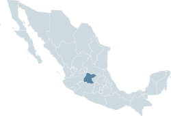
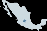
Mexico
The United Mexican States , commonly known as Mexico , is a federal constitutional republic in North America. It is bordered on the north by the United States; on the south and west by the Pacific Ocean; on the southeast by Guatemala, Belize, and the Caribbean Sea; and on the east by the Gulf of...
state
States of Mexico
The United Mexican States is a federal republic formed by 32 federal entities .According to the Constitution of 1917, the states of the federation are free and sovereign. Each state has their own congress and constitution, while the Federal District has only limited autonomy with a local Congress...
of Guanajuato
Guanajuato
Guanajuato officially Estado Libre y Soberano de Guanajuato is one of the 31 states which, with the Federal District, comprise the 32 Federal Entities of Mexico. It is divided in 46 municipalities and its capital city is Guanajuato....
is divided into 46 municipalities
Municipality
A municipality is essentially an urban administrative division having corporate status and usually powers of self-government. It can also be used to mean the governing body of a municipality. A municipality is a general-purpose administrative subdivision, as opposed to a special-purpose district...
(municipios):
|- align=center style="background:#d8edff"
!INEGI
National Institute of Statistics, Geography, and Data Processing
The National Institute of Statistic and Geography is an autonomous agency of the Mexican Government dedicated to coordinate the National System of Statistical and Geographical Information of the country...
code
!Municipality
!Municipal Seat
!Population.
! HDI
Human Development Index
The Human Development Index is a composite statistic used to rank countries by level of "human development" and separate "very high human development", "high human development", "medium human development", and "low human development" countries...
|-
| 001 || Abasolo
Abasolo, Guanajuato
Abasolo is a Mexican city located in the Southeast region of the state of Guanajuato. The municipality has an area of 601.73 square kilometres , and is bordered to the north by Pueblo Nuevo and Valle de Santiago, to the south by the state of Michoacán and Huanímaro, and to the west by Pénjamo and...
|| Abasolo
Abasolo, Guanajuato
Abasolo is a Mexican city located in the Southeast region of the state of Guanajuato. The municipality has an area of 601.73 square kilometres , and is bordered to the north by Pueblo Nuevo and Valle de Santiago, to the south by the state of Michoacán and Huanímaro, and to the west by Pénjamo and...
||77,094 || 0.7224
|-
| 002 || Acámbaro
Acámbaro
Acámbaro is a city and municipality in the southeastern corner of the Mexican state of Guanajuato, on the banks of the Lerma River, and the oldest of the 46 municipalities of Guanajuato. Acámbaro is noted as a major railway junction, a local transport hub, and the origin of the nationally famous...
|| Acámbaro
Acámbaro
Acámbaro is a city and municipality in the southeastern corner of the Mexican state of Guanajuato, on the banks of the Lerma River, and the oldest of the 46 municipalities of Guanajuato. Acámbaro is noted as a major railway junction, a local transport hub, and the origin of the nationally famous...
|| 101,762 || 0.7525
|-
| 003 || Allende || San Miguel de Allende
San Miguel de Allende
San Miguel de Allende is a city and municipality located in the far eastern part of the state of Guanajuato in central Mexico. It is 274 km from Mexico City and 97 km from the state capital of Guanajuato...
|| 139,297 || 0.7455
|-
| 004 || Apaseo el Alto
Apaseo el Alto
Apaseo el Alto is a Mexican city located in the state of Guanajuato. The municipality has an area of 491.81 square kilometres and is bordered to the north by Apaseo el Grande, to the east by the state of Querataro, to the south by Jerécuaro and Tarimoro, and to the northwest by Celaya...
|| Apaseo el Alto
Apaseo el Alto
Apaseo el Alto is a Mexican city located in the state of Guanajuato. The municipality has an area of 491.81 square kilometres and is bordered to the north by Apaseo el Grande, to the east by the state of Querataro, to the south by Jerécuaro and Tarimoro, and to the northwest by Celaya...
|| 57,942 || 0.7472
|-
| 005 || Apaseo el Grande
Apaseo el Grande
Apaseo el Grande is a Mexican city located in the state of Guanajuato. The municipality has an area of 415.26 square kilometres and is bordered to the north by Comonfort and San Miguel de Allende, to the east by the state of Querétaro, to the south by Apaseo el Alto, and to the west by Celaya...
|| Apaseo el Grande
Apaseo el Grande
Apaseo el Grande is a Mexican city located in the state of Guanajuato. The municipality has an area of 415.26 square kilometres and is bordered to the north by Comonfort and San Miguel de Allende, to the east by the state of Querétaro, to the south by Apaseo el Alto, and to the west by Celaya...
|| 73,863 || 0.7408
|-
| 006 || Atarjea
Atarjea
Atarjea is a Mexican city located in the easternmost region of the state of Guanajuato, within the Sierra Gorda range. The municipality has an area of 318 square kilometres and is bordered to the north by the state of San Luis Potosí, to the east and south by the state of Querétaro, and to the...
|| Atarjea
Atarjea
Atarjea is a Mexican city located in the easternmost region of the state of Guanajuato, within the Sierra Gorda range. The municipality has an area of 318 square kilometres and is bordered to the north by the state of San Luis Potosí, to the east and south by the state of Querétaro, and to the...
|| 5,035 || 0.6018
|-
| 007 || Celaya
Celaya
Celaya is a city and its surrounding municipality in the state of Guanajuato, Mexico, located in the southeast quadrant of the state. It is the third most populous city in the state, with a 2005 census population of 310,413. The municipality for which the city serves as municipal seat, had a...
|| Celaya
Celaya
Celaya is a city and its surrounding municipality in the state of Guanajuato, Mexico, located in the southeast quadrant of the state. It is the third most populous city in the state, with a 2005 census population of 310,413. The municipality for which the city serves as municipal seat, had a...
|| 415,869 || 0.8193
|-
| 008 || Manuel Doblado
Manuel Doblado, Guanajuato
Manuel Doblado is a Mexican municipality located in the state of Guanajuato. Its municipal seatis the city of the same name. Manuel Doblado has an area of 810.43 square kilometres and is bordered to the north by Romita, Purísima del Rincón and San Francisco del Rincón, to the southeast by...
|| Ciudad Manuel Doblado
Manuel Doblado, Guanajuato
Manuel Doblado is a Mexican municipality located in the state of Guanajuato. Its municipal seatis the city of the same name. Manuel Doblado has an area of 810.43 square kilometres and is bordered to the north by Romita, Purísima del Rincón and San Francisco del Rincón, to the southeast by...
|| 34,313 || 0.7292
|-
| 009 || Comonfort
Comonfort
Comonfort is a Mexican city located in the state of Guanajuato. The municipality has an area of 485.90 square kilometres and is bordered to the north and northeast by San Miguel de Allende, to the east by the state of Querétaro, to the south and southwest by Empalme Escobedo, Apaseo el Grande,...
|| Comonfort
Comonfort
Comonfort is a Mexican city located in the state of Guanajuato. The municipality has an area of 485.90 square kilometres and is bordered to the north and northeast by San Miguel de Allende, to the east by the state of Querétaro, to the south and southwest by Empalme Escobedo, Apaseo el Grande,...
|| 70,189 || 0.7354
|-
| 010 || Coroneo
Coroneo
Coroneo is a Mexican city and municipality located in the state of Guanajuato. The municipality has an area of 122.90 square kilometres and is bordered to the north and the east by the state of Querétaro, to the south by the state of Michoacán, and to the west by Jerécuaro...
|| Coroneo
Coroneo
Coroneo is a Mexican city and municipality located in the state of Guanajuato. The municipality has an area of 122.90 square kilometres and is bordered to the north and the east by the state of Querétaro, to the south by the state of Michoacán, and to the west by Jerécuaro...
|| 10,972 || 0.7284
|-
| 011 || Cortazar
Cortazar, Guanajuato
Cortazar is a city and its surrounding municipality located in the southeastern quadrant of the state of Guanajuato in Mexico. It is bordered to the north by Villagrán, to the north and east by Celaya, to the southeast by Tarimoro, to the south by Salvatierra, and to the west by Jaral del Progreso...
|| Cortázar
Cortazar, Guanajuato
Cortazar is a city and its surrounding municipality located in the southeastern quadrant of the state of Guanajuato in Mexico. It is bordered to the north by Villagrán, to the north and east by Celaya, to the southeast by Tarimoro, to the south by Salvatierra, and to the west by Jaral del Progreso...
|| 83,175 || 0.7729
|-
| 012 || Cuerámaro
Cuerámaro
Cuerámaro is a Mexican city located in Southwest region of the state of Guanajuato. The municipality has an area of 254.85 square kilometres and is bordered to the north by Romita, to the east by Abasolo, to the south by Pénjamo, and to the west by Manuel Doblado...
|| Cuerámaro
Cuerámaro
Cuerámaro is a Mexican city located in Southwest region of the state of Guanajuato. The municipality has an area of 254.85 square kilometres and is bordered to the north by Romita, to the east by Abasolo, to the south by Pénjamo, and to the west by Manuel Doblado...
|| 23,960 || 0.7359
|-
| 013 || Doctor Mora
Doctor Mora
Doctor Mora is a Mexican city located in Northeast region of the state of Guanajuato. The municipality has an area of 233.91 square kilometres and is bordered to the north by Victoria, to the east by Tierra Blanca, to the south by San José Iturbide, and to the west by San Luis de la Paz...
|| Doctor Mora
Doctor Mora
Doctor Mora is a Mexican city located in Northeast region of the state of Guanajuato. The municipality has an area of 233.91 square kilometres and is bordered to the north by Victoria, to the east by Tierra Blanca, to the south by San José Iturbide, and to the west by San Luis de la Paz...
|| 21,304 || 0.6821
|-
| 014 || Dolores Hidalgo
Dolores Hidalgo
Dolores Hidalgo Dolores Hidalgo Dolores Hidalgo (in full, Dolores Hidalgo Cuna de la Independencia Nacional is the name of a city and the surrounding municipality in the north-central part of the Mexican state of Guanajuato....
|| Dolores Hidalgo, Cuna de la Independencia Nacional
Dolores Hidalgo
Dolores Hidalgo Dolores Hidalgo Dolores Hidalgo (in full, Dolores Hidalgo Cuna de la Independencia Nacional is the name of a city and the surrounding municipality in the north-central part of the Mexican state of Guanajuato....
|| 134,641 || 0.7370
|-
| 015 || Guanajuato || Guanajuato || 153,364 || 0.7996
|-
| 016 || Huanímaro
Huanímaro
Huanímaro is a Mexican city located in Southwest region of the state of Guanajuato. The municipality has an area of 130.57 square kilometres and is bordered to the north and west by Abasolo, to the south by the state of Michoacán, and to the east by Valle de Santiago...
|| Huanímaro
Huanímaro
Huanímaro is a Mexican city located in Southwest region of the state of Guanajuato. The municipality has an area of 130.57 square kilometres and is bordered to the north and west by Abasolo, to the south by the state of Michoacán, and to the east by Valle de Santiago...
||18,456 || 0.7178
|-
| 017 || Irapuato || Irapuato || 463,103 || 0.7985
|-
| 018 || Jaral del Progreso
Jaral del Progreso
Jaral del Progreso is a Mexican city and municipality located in the Bajío of the state of Guanajuato. With an area of 174.37 square kilometres, Jaral del Progreso accounts for 0.57% of the surface of the state...
|| Jaral del Progreso
Jaral del Progreso
Jaral del Progreso is a Mexican city and municipality located in the Bajío of the state of Guanajuato. With an area of 174.37 square kilometres, Jaral del Progreso accounts for 0.57% of the surface of the state...
|| 31,780 || 0.7606
|-
| 019 || Jerécuaro
Jerécuaro
Jerécuaro is a Mexican city located in the lowlands of the state of Guanajuato. The municipality has an area of 828.3 square kilometres and is bordered to the north by Apaseo el Alto, to the east by Coroneo and the state of Querétaro, to the south by Tarandacuao, to the southwest with Acámbaro,...
|| Jerécuaro
Jerécuaro
Jerécuaro is a Mexican city located in the lowlands of the state of Guanajuato. The municipality has an area of 828.3 square kilometres and is bordered to the north by Apaseo el Alto, to the east by Coroneo and the state of Querétaro, to the south by Tarandacuao, to the southwest with Acámbaro,...
|| 46,137 || 0.6753
|-
| 020 || León
León, Guanajuato
The city of León, formally León de los Aldama is the sixth most populous city in Mexico and the first in the state of Guanajuato. It is also the seat of the municipality of León...
|| León
León, Guanajuato
The city of León, formally León de los Aldama is the sixth most populous city in Mexico and the first in the state of Guanajuato. It is also the seat of the municipality of León...
|| 1,278,087 || 0.8310
|-
| 021 || Moroleón
Moroleón
Moroleón is a city located in the same name municipality of the state of Guanajuato, adjacent to the border with the state of Michoacán, in Mexico....
|| Moroleón
Moroleón
Moroleón is a city located in the same name municipality of the state of Guanajuato, adjacent to the border with the state of Michoacán, in Mexico....
|| 46,751 || 0.8026
|-
| 022 || Ocampo
Ocampo, Guanajuato
Ocampo is a city located in the northwest region of the Mexican state of Guanajuato. The municipality has an area of 1,019.49 square kilometres and is bordered and to the south and east by San Felipe, to the north by the state of San Luis Potosí, to the west by the state of Jalisco...
|| Ocampo
Ocampo, Guanajuato
Ocampo is a city located in the northwest region of the Mexican state of Guanajuato. The municipality has an area of 1,019.49 square kilometres and is bordered and to the south and east by San Felipe, to the north by the state of San Luis Potosí, to the west by the state of Jalisco...
|| 20,579 || 0.7041
|-
| 023 || Pénjamo
Pénjamo
Penjamo Hidalgo Cradle, is the City head-board of the homonymous Municipality, one of 46 municipalities of Guanajuato's Mexican state. It is one of the cities with major commercial movement of the State, and is considered to be the major City of the Southwest of the entity and the city number 17...
|| Pénjamo
Pénjamo
Penjamo Hidalgo Cradle, is the City head-board of the homonymous Municipality, one of 46 municipalities of Guanajuato's Mexican state. It is one of the cities with major commercial movement of the State, and is considered to be the major City of the Southwest of the entity and the city number 17...
|| 138,157 || 0.7280
|-
| 024 || Pueblo Nuevo
Pueblo Nuevo, Guanajuato
Pueblo Nuevo is a municipality in the Mexican state of Guanajuato. Its borders are Salamanca, Irapuato, Valle de Santiago, Abasolo. It is the home town of the famous J. Carmen Villanueva.-References:* at ordenjuridico.gob.mx *...
|| Pueblo Nuevo
Pueblo Nuevo, Guanajuato
Pueblo Nuevo is a municipality in the Mexican state of Guanajuato. Its borders are Salamanca, Irapuato, Valle de Santiago, Abasolo. It is the home town of the famous J. Carmen Villanueva.-References:* at ordenjuridico.gob.mx *...
|| 5,790 || 0.7228
|-
| 025 || Purísima del Rincón
Purísima del Rincón
Purísima del Rincón is a Mexican municipality located in the state of Guanajuato. Its municipal seat is the city of Purísima de Bustos.The municipality has an area of 288.44 square kilometres , and is bordered to the north and east by San Francisco del Rincón, to the south by Manuel Doblado, and to...
|| Purísima de Bustos
Purísima del Rincón
Purísima del Rincón is a Mexican municipality located in the state of Guanajuato. Its municipal seat is the city of Purísima de Bustos.The municipality has an area of 288.44 square kilometres , and is bordered to the north and east by San Francisco del Rincón, to the south by Manuel Doblado, and to...
|| 55,910 || 0.7664
|-
| 026 || Romita
Romita
Romita is a Mexican city located in the Southwest region of the state of Guanajuato. The municipality has an area of 442.10 square kilometres and is bordered to the north by León, to the east by Silao, to the southeast by Abasolo and Cuerámaro, and to the east by Manuel Doblado and San Francisco...
|| Romita
Romita
Romita is a Mexican city located in the Southwest region of the state of Guanajuato. The municipality has an area of 442.10 square kilometres and is bordered to the north by León, to the east by Silao, to the southeast by Abasolo and Cuerámaro, and to the east by Manuel Doblado and San Francisco...
|| 50,580 || 0.7091
|-
| 027 || Salamanca
Salamanca, Guanajuato
Salamanca is a city in the Mexican state of Guanajuato.Founded January 1, 1603 as 'Villa de Salamanca' by the Viceroy Gaspar de Zuniga and Acevedo, fifth Earl of Monterrey, who was originally from Salamanca...
|| Salamanca
Salamanca, Guanajuato
Salamanca is a city in the Mexican state of Guanajuato.Founded January 1, 1603 as 'Villa de Salamanca' by the Viceroy Gaspar de Zuniga and Acevedo, fifth Earl of Monterrey, who was originally from Salamanca...
|| 233,253 || 0.7886
|-
| 028 || Salvatierra
Salvatierra, Guanajuato
Salvatierra is a Mexican city located in the valley of Huatzindeo in the lowlands of the state of Guanajuato. With an area of 507.70 square kilometres, Salvatierra accounts for 1.66% the total area of the state...
|| Salvatierra
Salvatierra, Guanajuato
Salvatierra is a Mexican city located in the valley of Huatzindeo in the lowlands of the state of Guanajuato. With an area of 507.70 square kilometres, Salvatierra accounts for 1.66% the total area of the state...
|| 92,411 || 0.7482
|-
| 029 || San Diego de la Unión
San Diego de la Unión
San Diego de la Unión is a Mexican city located in the Northwest region of the state of Guanajuato. The municipality has an area of 990.17 square kilometres and is bordered to the north by San Luis Potosí, to the east by San Luis de la Paz, to the south by Dolores Hidalgo, and to the west by San...
|| San Diego de la Unión
San Diego de la Unión
San Diego de la Unión is a Mexican city located in the Northwest region of the state of Guanajuato. The municipality has an area of 990.17 square kilometres and is bordered to the north by San Luis Potosí, to the east by San Luis de la Paz, to the south by Dolores Hidalgo, and to the west by San...
|| 34,401 || 0.6852
|-
| 030 || San Felipe
San Felipe, Guanajuato
San Felipe is a Mexican city and municipality located in the northwest region of the state of Guanajuato. The municipality has an area of 2,969.79 square kilometers , making it the biggest municipality in terms of size...
|| San Felipe
San Felipe, Guanajuato
San Felipe is a Mexican city and municipality located in the northwest region of the state of Guanajuato. The municipality has an area of 2,969.79 square kilometers , making it the biggest municipality in terms of size...
|| 95,896 || 0.7042
|-
| 031 || San Francisco del Rincón
San Francisco del Rincón
San Francisco del Rincón is a city and municipality in the western part of the state of Guanajuato, Mexico. The city serves as the municipal seat for the municipality of San Francisco del Rincón...
|| San Francisco del Rincón
San Francisco del Rincón
San Francisco del Rincón is a city and municipality in the western part of the state of Guanajuato, Mexico. The city serves as the municipal seat for the municipality of San Francisco del Rincón...
|| 103,127 || 0.7840
|-
| 032 || San José Iturbide
San José Iturbide
San José Iturbide is a Mexican city located in the Northeast region of the state of Guanajuato, within the Sierra Gorda range...
|| San José Iturbide
San José Iturbide
San José Iturbide is a Mexican city located in the Northeast region of the state of Guanajuato, within the Sierra Gorda range...
|| 59,127 || 0.7499
|-
| 033 || San Luis de la Paz
San Luis de la Paz
San Luis de la Paz is a city and its surrounding municipality of the same name located in the northeastern part of the state of Guanajuato in Mexico. A charming city with great historic and cultural wealth, was founded on August 25, 1552, as a defensive town in the Spanish Silver Road, which linked...
|| San Luis de la Paz
San Luis de la Paz
San Luis de la Paz is a city and its surrounding municipality of the same name located in the northeastern part of the state of Guanajuato in Mexico. A charming city with great historic and cultural wealth, was founded on August 25, 1552, as a defensive town in the Spanish Silver Road, which linked...
|| 101,370 || 0.7279
|-
| 034 || Santa Catarina
Santa Catarina, Guanajuato
Santa Catarina is a Mexican city located in the Northeast region of the state of Guanajuato, within the Sierra Gorda range. The municipality has an area of 193.67 square kilometres and is bordered to the north by Victoria and Xichú, to the east by the state of Querétaro, to the south by Tierra...
|| Santa Catarina
Santa Catarina, Guanajuato
Santa Catarina is a Mexican city located in the Northeast region of the state of Guanajuato, within the Sierra Gorda range. The municipality has an area of 193.67 square kilometres and is bordered to the north by Victoria and Xichú, to the east by the state of Querétaro, to the south by Tierra...
|| 4,554 || 0.6090
|-
| 035 || Santa Cruz de Juventino Rosas
Santa Cruz de Juventino Rosas
Santa Cruz de Juventino Rosas is a Mexican city located in the central east region of the state of Guanajuato. The municipality has an area of 428.64 square kilometres and is bordered to the north by San Miguel de Allende, to the northeast by Comonfort, to the southeast by Celaya, to the south...
|| Santa Cruz de Juventino Rosas
Santa Cruz de Juventino Rosas
Santa Cruz de Juventino Rosas is a Mexican city located in the central east region of the state of Guanajuato. The municipality has an area of 428.64 square kilometres and is bordered to the north by San Miguel de Allende, to the northeast by Comonfort, to the southeast by Celaya, to the south...
|| 70,323 || 0.7289
|-
| 036 || Santiago Maravatío
Santiago Maravatío
Santiago Maravatío is a Mexican city located in the Bajío of the state of Guanajuato. With an area of 91.760 square kilometres, Santiago Maravatío accounts for less than 1% of the surface of the state...
|| Santiago Maravatío
Santiago Maravatío
Santiago Maravatío is a Mexican city located in the Bajío of the state of Guanajuato. With an area of 91.760 square kilometres, Santiago Maravatío accounts for less than 1% of the surface of the state...
||6,389 || 0.7114
|-
| 037 || Silao
Silao
Silao is a city in the west-central part of the state of Guanajuato in Mexico. It is the seat of the municipio with the same name. As of the 2005 census, the city had a population of 147,123, making it the seventh-largest community in the state...
|| Silao
Silao
Silao is a city in the west-central part of the state of Guanajuato in Mexico. It is the seat of the municipio with the same name. As of the 2005 census, the city had a population of 147,123, making it the seventh-largest community in the state...
||147,123 || 0.7545
|-
| 038 || Tarandacuao
Tarandacuao
Tarandacuao is a Mexican city located in the lowlands of the state of Guanajuato. The municipality has an area of 117.39 square kilometres, and is bordered to the north and east by Jerécuaro, to the south by the state of Michoacán, and to the west by Acámbaro. The municipality had 11,583...
|| Tarandacuao
Tarandacuao
Tarandacuao is a Mexican city located in the lowlands of the state of Guanajuato. The municipality has an area of 117.39 square kilometres, and is bordered to the north and east by Jerécuaro, to the south by the state of Michoacán, and to the west by Acámbaro. The municipality had 11,583...
|| 10,252 || 0.7527
|-
| 039 || Tarimoro
Tarimoro
This article is about the Municipality. For the City with the same name, see Tarimoro, GuanajuatoTarimoro is one of the 46 municipalities of the Mexican state of Guanajuato. The municipal seat is the city of Tarimoro....
|| Tarimoro
Tarimoro
This article is about the Municipality. For the City with the same name, see Tarimoro, GuanajuatoTarimoro is one of the 46 municipalities of the Mexican state of Guanajuato. The municipal seat is the city of Tarimoro....
|| 33,104 || 0.7252
|-
| 040 || Tierra Blanca
Tierra Blanca, Guanajuato
Tierra Blanca is a Mexican city located in the Northeast region of the state of Guanajuato. The municipality has an area of 391.65 square kilometres and is bordered to the north by Santa Catarina, to the south and the east to the state of Querétaro, to the west by San José Iturbide and to the...
|| Tierra Blanca
Tierra Blanca, Guanajuato
Tierra Blanca is a Mexican city located in the Northeast region of the state of Guanajuato. The municipality has an area of 391.65 square kilometres and is bordered to the north by Santa Catarina, to the south and the east to the state of Querétaro, to the west by San José Iturbide and to the...
|| 16,136 || 0.6156
|-
| 041 || Uriangato
Uriangato
Uriangato is one of 46 cities in Guanajuato, located in the borderline between the states of Guanajuato and Michoacán in the region West-Center of Mexico...
|| Uriangato
Uriangato
Uriangato is one of 46 cities in Guanajuato, located in the borderline between the states of Guanajuato and Michoacán in the region West-Center of Mexico...
|| 53,077 || 0.7786
|-
| 042 || Valle de Santiago
Valle de Santiago
Valle de Santiago is a municipio in the Mexican state of Guanajuato, and also the name of its largest township and cabecera municipal . The municipality is located in the southern portion of the state in the Bajío region of central Mexico, and has an area of some...
|| Valle de Santiago
Valle de Santiago
Valle de Santiago is a municipio in the Mexican state of Guanajuato, and also the name of its largest township and cabecera municipal . The municipality is located in the southern portion of the state in the Bajío region of central Mexico, and has an area of some...
|| 127,945 || 0.7475
|-
| 043 || Victoria
Victoria, Guanajuato
Victoria is a Mexican city located in the Northeast region of the state of Guanajuato, within the Sierra Gorda range. The municipality has an area of 1009.437 square kilometres and is bordered to the north by the state of San Luis Potosí, to the east by Xichú, to the south by Santa Catarina and...
|| Victoria
Victoria, Guanajuato
Victoria is a Mexican city located in the Northeast region of the state of Guanajuato, within the Sierra Gorda range. The municipality has an area of 1009.437 square kilometres and is bordered to the north by the state of San Luis Potosí, to the east by Xichú, to the south by Santa Catarina and...
|| 19,112 || 0.6563
|-
| 044 || Villagrán
Villagrán, Guanajuato
Villagrán is a Mexican city located in the state of Guanajuato. With an area of 125.4 square kilometres, Villagrán accounts for 0.41% of the surface of the state. It is bordered to the north by Santa Cruz de Juventino Rosas, to the east by Celaya, to the south by Cortazar, and to the west by...
|| Villagrán
Villagrán, Guanajuato
Villagrán is a Mexican city located in the state of Guanajuato. With an area of 125.4 square kilometres, Villagrán accounts for 0.41% of the surface of the state. It is bordered to the north by Santa Cruz de Juventino Rosas, to the east by Celaya, to the south by Cortazar, and to the west by...
|| 49,563 || 0.7673
|-
| 045 || Xichú
Xichú
Xichú is a Mexican city located in the Northeast region of the state of Guanajuato. The municipality is entirely within the Sierra Gorda range and has an area of 912.20 square kilometres...
|| Xichú
Xichú
Xichú is a Mexican city located in the Northeast region of the state of Guanajuato. The municipality is entirely within the Sierra Gorda range and has an area of 912.20 square kilometres...
|| 10,592 || 0.6373
|-
| 046 || Yuriria
Yuriria
Yuririapundaro, Guanajuato, Mexico, also known as Yuriria, is one of 46 municipalities in the Mexican state of Guanajuato. Its location and historical importance are key factors to the outstanding and significal importance of the municipality....
|| Yuriria
Yuriria
Yuririapundaro, Guanajuato, Mexico, also known as Yuriria, is one of 46 municipalities in the Mexican state of Guanajuato. Its location and historical importance are key factors to the outstanding and significal importance of the municipality....
|| 63,447 || 0.7344
|}