

Yuriria
Encyclopedia
Yuririapundaro, Guanajuato
, Mexico
, also known as Yuriria, is one of 46 municipalities in the Mexican
state of Guanajuato
. Its location and historical importance are key factors to the outstanding and significal importance of the municipality
.
Located 20°12'44.76" N 101°07'51.03" W
", or lowlands, of Guanajuato
. It is bordered to the east by Salvatierra
and Santiago Maravatío
, to the north by Jaral del Progreso
and Valle de Santiago
, to the south by Uriangato
and Moroleón
, and to the west by the state of Michoacán
. Its total area is 656 kilometres².
of Yuriria and its surrounding areas totals 89,126 people, which leaves behind self-governing states like Andorra
, Greenland
, and Monaco
. Of these people only 26,337 live in urban Yuriria, while 62, 789 live in the rural areas surrounding the main town. The biggest rural municipalities in Yuriria are Cerano
(pop. 7,796), La Calera (pop. 3,896) and Casacuarán
(pop. 3,398). Santa Monica Ozumbilla is one of the oldest communities in Yuriria dating as far back as the early 16th century.
. Some of these include:
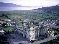 The Ex-Covento, or cathedral is probably the most important architectural structure in Yuriria, as well as an important icon in the state in general. Since its construction in November of 1550, and its culmination on 1559, its massive size and dazzling structure captured the attention of generations, and ultimately put Yuriria on the map. Its construction was started by Fray Diego de Chavez, nephew of the conquistador Don Pedro Alvarado and was designed by the famous architect Pedro del Toro.
Guanajuato
Guanajuato officially Estado Libre y Soberano de Guanajuato is one of the 31 states which, with the Federal District, comprise the 32 Federal Entities of Mexico. It is divided in 46 municipalities and its capital city is Guanajuato....
, Mexico
Mexico
The United Mexican States , commonly known as Mexico , is a federal constitutional republic in North America. It is bordered on the north by the United States; on the south and west by the Pacific Ocean; on the southeast by Guatemala, Belize, and the Caribbean Sea; and on the east by the Gulf of...
, also known as Yuriria, is one of 46 municipalities in the Mexican
Mexico
The United Mexican States , commonly known as Mexico , is a federal constitutional republic in North America. It is bordered on the north by the United States; on the south and west by the Pacific Ocean; on the southeast by Guatemala, Belize, and the Caribbean Sea; and on the east by the Gulf of...
state of Guanajuato
Guanajuato
Guanajuato officially Estado Libre y Soberano de Guanajuato is one of the 31 states which, with the Federal District, comprise the 32 Federal Entities of Mexico. It is divided in 46 municipalities and its capital city is Guanajuato....
. Its location and historical importance are key factors to the outstanding and significal importance of the municipality
Municipality
A municipality is essentially an urban administrative division having corporate status and usually powers of self-government. It can also be used to mean the governing body of a municipality. A municipality is a general-purpose administrative subdivision, as opposed to a special-purpose district...
.
Located 20°12'44.76" N 101°07'51.03" W
Location and size
Yuriria is located in the "BajíoBajío
The Bajío is a region of Central Mexico that includes the plains south of the Sierra de Guanajuato, in the state of Guanajuato, as well as parts of the states of Querétaro and Michoacán .In general parlance, it is usually associated with the States of Guanajuato and Querétaro, although it only...
", or lowlands, of Guanajuato
Guanajuato
Guanajuato officially Estado Libre y Soberano de Guanajuato is one of the 31 states which, with the Federal District, comprise the 32 Federal Entities of Mexico. It is divided in 46 municipalities and its capital city is Guanajuato....
. It is bordered to the east by Salvatierra
Salvatierra, Guanajuato
Salvatierra is a Mexican city located in the valley of Huatzindeo in the lowlands of the state of Guanajuato. With an area of 507.70 square kilometres, Salvatierra accounts for 1.66% the total area of the state...
and Santiago Maravatío
Santiago Maravatío
Santiago Maravatío is a Mexican city located in the Bajío of the state of Guanajuato. With an area of 91.760 square kilometres, Santiago Maravatío accounts for less than 1% of the surface of the state...
, to the north by Jaral del Progreso
Jaral del Progreso
Jaral del Progreso is a Mexican city and municipality located in the Bajío of the state of Guanajuato. With an area of 174.37 square kilometres, Jaral del Progreso accounts for 0.57% of the surface of the state...
and Valle de Santiago
Valle de Santiago
Valle de Santiago is a municipio in the Mexican state of Guanajuato, and also the name of its largest township and cabecera municipal . The municipality is located in the southern portion of the state in the Bajío region of central Mexico, and has an area of some...
, to the south by Uriangato
Uriangato
Uriangato is one of 46 cities in Guanajuato, located in the borderline between the states of Guanajuato and Michoacán in the region West-Center of Mexico...
and Moroleón
Moroleón
Moroleón is a city located in the same name municipality of the state of Guanajuato, adjacent to the border with the state of Michoacán, in Mexico....
, and to the west by the state of Michoacán
Michoacán
Michoacán officially Estado Libre y Soberano de Michoacán de Ocampo is one of the 31 states which, with the Federal District, comprise the 32 Federal Entities of Mexico. It is divided in 113 municipalities and its capital city is Morelia...
. Its total area is 656 kilometres².
Population
The populationPopulation
A population is all the organisms that both belong to the same group or species and live in the same geographical area. The area that is used to define a sexual population is such that inter-breeding is possible between any pair within the area and more probable than cross-breeding with individuals...
of Yuriria and its surrounding areas totals 89,126 people, which leaves behind self-governing states like Andorra
Andorra
Andorra , officially the Principality of Andorra , also called the Principality of the Valleys of Andorra, , is a small landlocked country in southwestern Europe, located in the eastern Pyrenees mountains and bordered by Spain and France. It is the sixth smallest nation in Europe having an area of...
, Greenland
Greenland
Greenland is an autonomous country within the Kingdom of Denmark, located between the Arctic and Atlantic Oceans, east of the Canadian Arctic Archipelago. Though physiographically a part of the continent of North America, Greenland has been politically and culturally associated with Europe for...
, and Monaco
Monaco
Monaco , officially the Principality of Monaco , is a sovereign city state on the French Riviera. It is bordered on three sides by its neighbour, France, and its centre is about from Italy. Its area is with a population of 35,986 as of 2011 and is the most densely populated country in the...
. Of these people only 26,337 live in urban Yuriria, while 62, 789 live in the rural areas surrounding the main town. The biggest rural municipalities in Yuriria are Cerano
Cerano
Cerano is a comune in the Province of Novara in the Italian region Piedmont, located about 90 km northeast of Turin and about 14 km southeast of Novara...
(pop. 7,796), La Calera (pop. 3,896) and Casacuarán
Casacuarán
San Pablo Casacuarán is a small town located in the southern region of the state of Guanajuato, Mexico. Commonly known just as Casacuarán, it stands on the road connecting the cities of Yuriria and Salvatierra. Every January the town has a celebration of San Pablo on January 25th...
(pop. 3,398). Santa Monica Ozumbilla is one of the oldest communities in Yuriria dating as far back as the early 16th century.
Town icons
Yuriria has many structural, as well as geographical icons, that throughout the years have become major sight locations in the state of GuanajuatoGuanajuato
Guanajuato officially Estado Libre y Soberano de Guanajuato is one of the 31 states which, with the Federal District, comprise the 32 Federal Entities of Mexico. It is divided in 46 municipalities and its capital city is Guanajuato....
. Some of these include:
Ex-Convento