
Munhall, Pennsylvania
Encyclopedia
Munhall is a borough in Allegheny County
, Pennsylvania
, on the west bank of the Monongahela River
, 8 miles (13 km) south of the confluence of the Monongahela and the Allegheny
rivers where the Ohio River
begins. It abuts the borough of Homestead
. A large part of the Homestead Works of the Carnegie Steel Company
existed in Munhall. Steel products were the only items made in Munhall in 1910 when 5,185 people lived here. In 1940, 13,900 people lived in Munhall. The population was 11,406 at the 2010 census. Munhall, along with the boroughs of Homestead and West Homestead
, are served by the Steel Valley School District
.
, located in Munhall, was donated by Andrew Carnegie
in 1896. It has been restored and modernized during the last quarter of a century. New electrical lighting has been installed; computers for the use of visitors have been installed; the indoors gloominess has vanished. Additionally, there are indoor pools, basketball courts, and other recreational facilities.
In 2000, Continental Realestate Companies opened The Waterfront
. This large "LifeStyle" shopping center was built on the former site of the Carnegie Steel Works. Most of the structures associated with the steel mills on this site were demolished during construction. Still standing in the Waterfront development are some of the brick stacks from the Homestead Steel Works. In addition, near the river is a former mill structure known as the Pump House which was restored by the developer.
According to the United States Census Bureau
, the borough has a total area of 2.4 square miles (6.2 km²), of which 2.3 square miles (6 km²) is land and 0.1 square mile (0.258998811 km²), or 4.55%, is water.
, West Homestead
and the Pittsburgh neighborhood of Lincoln Place
to the west, by West Mifflin
to the south and east, and by Whitaker
to the east. Across the Monongahela River
are the boroughs of Rankin
and Swissvale
to the northeast, and the city of Pittsburgh to the north.
of 2000, there were 12,264 people, 5,364 households, and 3,239 families residing in the borough. The population density
was 5,311.2 people per square mile (2,049.9/km²). There were 5,780 housing units at an average density of 2,503.2 per square mile (966.1/km²). The racial makeup of the borough was 94.78% White, 3.38% African American, 0.02% Native American, 0.61% Asian, 0.29% from other races
, and 0.92% from two or more races. Hispanic or Latino of any race were 0.80% of the population.
There were 5,364 households out of which 24.5% had children under the age of 18 living with them, 43.5% were married couples
living together, 13.4% had a female householder with no husband present, and 39.6% were non-families. 35.7% of all households were made up of individuals and 19.3% had someone living alone who was 65 years of age or older. The average household size was 2.25 and the average family size was 2.95.
In the borough the population was spread out with 20.7% under the age of 18, 6.9% from 18 to 24, 26.8% from 25 to 44, 23.2% from 45 to 64, and 22.3% who were 65 years of age or older. The median age was 42 years. For every 100 females there were 85.0 males. For every 100 females age 18 and over, there were 81.3 males.
The median income for a household in the borough was $32,832, and the median income for a family was $41,847. Males had a median income of $32,202 versus $24,029 for females. The per capita income
for the borough was $18,052. About 9.7% of families and 11.9% of the population were below the poverty line, including 18.2% of those under age 18 and 7.8% of those age 65 or over.
Allegheny County, Pennsylvania
Allegheny County is a county in the southwestern part of the U.S. state of Pennsylvania. As of the 2010 census, the population was 1,223,348; making it the second most populous county in Pennsylvania, following Philadelphia County. The county seat is Pittsburgh...
, Pennsylvania
Pennsylvania
The Commonwealth of Pennsylvania is a U.S. state that is located in the Northeastern and Mid-Atlantic regions of the United States. The state borders Delaware and Maryland to the south, West Virginia to the southwest, Ohio to the west, New York and Ontario, Canada, to the north, and New Jersey to...
, on the west bank of the Monongahela River
Monongahela River
The Monongahela River is a river on the Allegheny Plateau in north-central West Virginia and southwestern Pennsylvania in the United States...
, 8 miles (13 km) south of the confluence of the Monongahela and the Allegheny
Allegheny River
The Allegheny River is a principal tributary of the Ohio River; it is located in the Eastern United States. The Allegheny River joins with the Monongahela River to form the Ohio River at the "Point" of Point State Park in Downtown Pittsburgh, Pennsylvania...
rivers where the Ohio River
Ohio River
The Ohio River is the largest tributary, by volume, of the Mississippi River. At the confluence, the Ohio is even bigger than the Mississippi and, thus, is hydrologically the main stream of the whole river system, including the Allegheny River further upstream...
begins. It abuts the borough of Homestead
Homestead, Pennsylvania
Homestead is a borough in Allegheny County, Pennsylvania, USA, in the "Mon Valley," southeast of downtown Pittsburgh and directly across the river from the city limit line. The borough is known for the Homestead Strike of 1892, an important event in the history of labor relations in the United...
. A large part of the Homestead Works of the Carnegie Steel Company
Carnegie Steel Company
Carnegie Steel Company was a steel producing company created by Andrew Carnegie to manage business at his steel mills in the Pittsburgh, Pennsylvania area in the late 19th century.-Creation:...
existed in Munhall. Steel products were the only items made in Munhall in 1910 when 5,185 people lived here. In 1940, 13,900 people lived in Munhall. The population was 11,406 at the 2010 census. Munhall, along with the boroughs of Homestead and West Homestead
West Homestead, Pennsylvania
West Homestead is a borough in Allegheny County, Pennsylvania, southeast of Pittsburgh, on the Monongahela River. Heavy industries associated with nearby steel mills existed here. Established were axle works, brickworks, and manufactories of machinery, car wheels, etc. In 1910, 3,009 people lived...
, are served by the Steel Valley School District
Steel Valley School District
Steel Valley School District is a small, suburban public school district in the state of Pennsylvania. It is located to the southeast of the City of Pittsburgh. It serves the boroughs of Homestead, Munhall, and West Homestead, former mill towns. Steel Valley School District encompasses...
.
Attractions
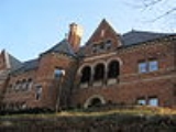
The Homestead LibraryCarnegie Library of Homestead
-References:...
, located in Munhall, was donated by Andrew Carnegie
Andrew Carnegie
Andrew Carnegie was a Scottish-American industrialist, businessman, and entrepreneur who led the enormous expansion of the American steel industry in the late 19th century...
in 1896. It has been restored and modernized during the last quarter of a century. New electrical lighting has been installed; computers for the use of visitors have been installed; the indoors gloominess has vanished. Additionally, there are indoor pools, basketball courts, and other recreational facilities.
In 2000, Continental Realestate Companies opened The Waterfront
The Waterfront
The Waterfront is a super-regional open air shopping mall spanning the three boroughs of Homestead, West Homestead and Munhall near Pittsburgh. The shopping mall sits on land once occupied by U.S. Steel's Homestead Steel Works plant, which closed in 1987. It has a gross leasable area of in "The...
. This large "LifeStyle" shopping center was built on the former site of the Carnegie Steel Works. Most of the structures associated with the steel mills on this site were demolished during construction. Still standing in the Waterfront development are some of the brick stacks from the Homestead Steel Works. In addition, near the river is a former mill structure known as the Pump House which was restored by the developer.
Geography
Munhall is located at 40°23′28"N 79°54′4"W (40.391202, -79.901221).According to the United States Census Bureau
United States Census Bureau
The United States Census Bureau is the government agency that is responsible for the United States Census. It also gathers other national demographic and economic data...
, the borough has a total area of 2.4 square miles (6.2 km²), of which 2.3 square miles (6 km²) is land and 0.1 square mile (0.258998811 km²), or 4.55%, is water.
Surrounding communities
Munhall is bordered by HomesteadHomestead, Pennsylvania
Homestead is a borough in Allegheny County, Pennsylvania, USA, in the "Mon Valley," southeast of downtown Pittsburgh and directly across the river from the city limit line. The borough is known for the Homestead Strike of 1892, an important event in the history of labor relations in the United...
, West Homestead
West Homestead, Pennsylvania
West Homestead is a borough in Allegheny County, Pennsylvania, southeast of Pittsburgh, on the Monongahela River. Heavy industries associated with nearby steel mills existed here. Established were axle works, brickworks, and manufactories of machinery, car wheels, etc. In 1910, 3,009 people lived...
and the Pittsburgh neighborhood of Lincoln Place
Lincoln Place (Pittsburgh)
Lincoln Place is a neighborhood in the 31st ward of Pittsburgh, Pennsylvania, located in the southeast corner of the city. It spans two ZIP codes, 15207 and 15120, and is represented on the by Douglas Shields....
to the west, by West Mifflin
West Mifflin, Pennsylvania
West Mifflin is a borough in Allegheny County, Pennsylvania, United States, located southeast of downtown Pittsburgh. The population was 20,313 at the 2010 census....
to the south and east, and by Whitaker
Whitaker, Pennsylvania
Whitaker is a borough in Allegheny County, Pennsylvania, United States, and is on the Monongahela River upriver from Pittsburgh. The population was 1,271 at the 2010 census.The borough is named for James Whitaker, who was deeded the land in 1788....
to the east. Across the Monongahela River
Monongahela River
The Monongahela River is a river on the Allegheny Plateau in north-central West Virginia and southwestern Pennsylvania in the United States...
are the boroughs of Rankin
Rankin, Pennsylvania
Rankin is a borough in Allegheny County, Pennsylvania, United States, south of Pittsburgh on the Monongahela River. Early in the 20th century, Rankin specialized in manufacturing steel and wire goods...
and Swissvale
Swissvale, Pennsylvania
Swissvale is a borough in Allegheny County, Pennsylvania, east of downtown Pittsburgh. Named for a farmstead owned by abolitionist and early feminist Jane Swisshelm, during the industrial age it was the site of the Union Switch and Signal Company of George Westinghouse. The population was 8,983 at...
to the northeast, and the city of Pittsburgh to the north.
Demographics
As of the censusCensus
A census is the procedure of systematically acquiring and recording information about the members of a given population. It is a regularly occurring and official count of a particular population. The term is used mostly in connection with national population and housing censuses; other common...
of 2000, there were 12,264 people, 5,364 households, and 3,239 families residing in the borough. The population density
Population density
Population density is a measurement of population per unit area or unit volume. It is frequently applied to living organisms, and particularly to humans...
was 5,311.2 people per square mile (2,049.9/km²). There were 5,780 housing units at an average density of 2,503.2 per square mile (966.1/km²). The racial makeup of the borough was 94.78% White, 3.38% African American, 0.02% Native American, 0.61% Asian, 0.29% from other races
Race (United States Census)
Race and ethnicity in the United States Census, as defined by the Federal Office of Management and Budget and the United States Census Bureau, are self-identification data items in which residents choose the race or races with which they most closely identify, and indicate whether or not they are...
, and 0.92% from two or more races. Hispanic or Latino of any race were 0.80% of the population.
There were 5,364 households out of which 24.5% had children under the age of 18 living with them, 43.5% were married couples
Marriage
Marriage is a social union or legal contract between people that creates kinship. It is an institution in which interpersonal relationships, usually intimate and sexual, are acknowledged in a variety of ways, depending on the culture or subculture in which it is found...
living together, 13.4% had a female householder with no husband present, and 39.6% were non-families. 35.7% of all households were made up of individuals and 19.3% had someone living alone who was 65 years of age or older. The average household size was 2.25 and the average family size was 2.95.
In the borough the population was spread out with 20.7% under the age of 18, 6.9% from 18 to 24, 26.8% from 25 to 44, 23.2% from 45 to 64, and 22.3% who were 65 years of age or older. The median age was 42 years. For every 100 females there were 85.0 males. For every 100 females age 18 and over, there were 81.3 males.
The median income for a household in the borough was $32,832, and the median income for a family was $41,847. Males had a median income of $32,202 versus $24,029 for females. The per capita income
Per capita income
Per capita income or income per person is a measure of mean income within an economic aggregate, such as a country or city. It is calculated by taking a measure of all sources of income in the aggregate and dividing it by the total population...
for the borough was $18,052. About 9.7% of families and 11.9% of the population were below the poverty line, including 18.2% of those under age 18 and 7.8% of those age 65 or over.