

Mount Wilson Toll Road
Encyclopedia
Toll road
A toll road is a privately or publicly built road for which a driver pays a toll for use. Structures for which tolls are charged include toll bridges and toll tunnels. Non-toll roads are financed using other sources of revenue, most typically fuel tax or general tax funds...
which ascended Mount Wilson
Mount Wilson (California)
Mount Wilson is one of the better known peaks in the San Gabriel Mountains, part of the Angeles National Forest in Los Angeles County, California. It is the location of the Mount Wilson Observatory and has become the astronomical center of Southern California with and telescopes, and and tall...
via a vehicular passable road from the base of the foothills in Altadena
Altadena, California
Altadena is an unincorporated area and census-designated place in Los Angeles County, California, United States, approximately from the downtown Los Angeles Civic Center, and directly north of the city of Pasadena, California...
. It was accessible from Pasadena
Pasadena, California
Pasadena is a city in Los Angeles County, California, United States. Although famous for hosting the annual Rose Bowl football game and Tournament of Roses Parade, Pasadena is the home to many scientific and cultural institutions, including the California Institute of Technology , the Jet...
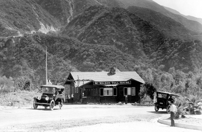
via Santa Anita Avenue which drove right to the front porch of the toll house. The road is still accessible to non-vehicular traffic (hikers, bicyclists, and horses) by way of Eaton Canyon
Eaton Canyon
Eaton Canyon is a major canyon beginning at the Eaton Saddle near Mount Markham and San Gabriel Peak in the San Gabriel Mountains in the Angeles National Forest, USA. Its drainage flows into the Rio Hondo river and then into the Los Angeles River...
(either from the Nature Center entrance, or an access gate on Pinecrest Drive, just off Altadena Drive in Altadena). Segments of it have been closed at various times due to landslides. A 2005 landslide destroyed 50 yards of the road, but it has since been rebuilt and reopened.
Mount Wilson had always been active with human passage starting from the days of the local Indians. It was Benjamin Davis Wilson who established a proper trail to the summit of Mt. Wilson from Sierra Madre
Sierra Madre, California
The city of Sierra Madre is a municipality in Los Angeles County, California whose population was 10,917 at the 2010 census, up from 10,580 at the time of the 2000 census. The city is located in the Foothills of the San Gabriel Mountains below the southern edge of the Angeles National Forest. ...
through the Santa Anita Canyon
Santa Anita Canyon
Santa Anita Canyon is a canyon in the San Gabriel Mountains, within the Angeles National Forest in Los Angeles County, California.-Geography:...
.
Inception of toll road
Telescope
A telescope is an instrument that aids in the observation of remote objects by collecting electromagnetic radiation . The first known practical telescopes were invented in the Netherlands at the beginning of the 1600s , using glass lenses...
in 1889, which brought its own problems of transporting the instrument up the old Wilson trail, caused an interest in a Mt. Wilson roadway, something more than a trail.
In June 1889, Judge Benjamin Eaton gathered a group of prominent Pasadena businessmen to consider building a wagon
Wagon
A wagon is a heavy four-wheeled vehicle pulled by draught animals; it was formerly often called a wain, and if low and sideless may be called a dray, trolley or float....
road to Mt. Wilson. There were 18 of the men who agreed to contribute capital
Financial capital
Financial capital can refer to money used by entrepreneurs and businesses to buy what they need to make their products or provide their services or to that sector of the economy based on its operation, i.e. retail, corporate, investment banking, etc....
; on July 12, 1889 they incorporated "The Pasadena and Mount Wilson Toll Road Company." However, the company failed before there was any progress on a roadway.
Within a couple of years five of the original investors reorganized and refinanced the project, but since the Harvard telescope had been removed and interest in Mt. Wilson had tailed off, they thought it better to downsize the project from a twelve foot road to a four foot road. By June 1891, after only five months work, a usable ten mile (16 km) trail was established. In July the new toll road was officially opened to the public and the toll fixed by the Los Angeles County Board of Supervisors
Los Angeles County Board of Supervisors
The Los Angeles County Board of Supervisors is the five-member nonpartisan governing board of Los Angeles County, California. Members of the board of supervisors are elected by district. They were as of December 2, 2008:*District 1: Gloria Molina...
at 25 cents for hikers and 50 cents for horseback. The new road was called the "New Mt. Wilson Trail" and it soon became more popular than the old Sierra Madre trail. Foot and pack animal
Pack animal
A pack animal or beast of burden is a working animal used by humans as means of transporting materials by attaching them so their weight bears on the animal's back; the term may be applied to either an individual animal or a species so employed...
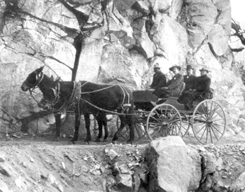
traffic became so heavy that in June of 1893 the trail was widened to six feet, making two way travel much easier.
The Mt. Wilson Observatories
General Land Office
The General Land Office was an independent agency of the United States government responsible for public domain lands in the United States. It was created in 1812 to take over functions previously conducted by the United States Department of the Treasury...
$800 for title to 640 acres (2.6 km²) on the mountain top. In 1904, The Mount Wilson Toll Road Company enlarged its holdings to 1050 acres (4 km²). The company entered into a 99 year lease
Lease
A lease is a contractual arrangement calling for the lessee to pay the lessor for use of an asset. A rental agreement is a lease in which the asset is tangible property...
with the Carnegie Institution in 1905, providing 40 acres (161,874.4 m²) of the mountain top for the location of a new observatory, today known as the Mount Wilson Observatory
Mount Wilson Observatory
The Mount Wilson Observatory is an astronomical observatory in Los Angeles County, California, United States. The MWO is located on Mount Wilson, a 5,715 foot peak in the San Gabriel Mountains near Pasadena, northeast of Los Angeles...
. Those involved with the new observatory were given free use of the toll road and half the water rights on the mountain. In return, the Carnegie Institution agreed that the public would always have access to the observatory.
The Carnegie Observatory renewed interest in Mt. Wilson and attracted sightseers to the mountain top. In 1905, to accommodate the many new visitors, the toll road company constructed a one story hotel with cottages situated around the main building for guests staying overnight. Destroyed by a fire in 1913, the original hotel was replaced by a larger one on the same site which included a large swimming pool.
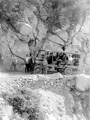
As new, larger telescopes were designed for the Carnegie Observatory, an automobile roadway became necessary to accommodate the trucks hauling parts up the mountain. In 1907 the trail was widened to ten feet with most of the work being done by hand with the use of Japanese laborers and mule-drawn scrapers. The road was widened to a full 12 feet (4 m) roadway in 1917 to facilitate the transportation of parts for the 100 inches (2,540 mm) Hooker Telescope.
Despite the advertised access for automobiles, the driving public was discouraged from using the toll road. First there was the fear of encountering large freight trucks servicing the observatories, unless drivers phoned ahead up the mountain. Then there were the sharp turns that required most cars to negotiate dangerously precipitous road edges. Mr. L. L. Whitman of Pasadena who made the ascent in his 1907 Franklin
Franklin (automobile)
The Franklin Automobile Company was a manufacturer of automobiles in the United States between 1902 and 1934 in Syracuse, New York. Herbert H. Franklin, the founder, began his career in the metal die casting business before establishing his automobile enterprise.Franklin founded the H. H. Franklin...
said, "Not for five hundred dollar would I make the trip again." For those preferring not to drive, there was the popular Mt. Wilson Stage Line.
In its closing years
By the early 1930s a new high speed highway was being built from La CañadaLa Cañada Flintridge, California
La Cañada Flintridge is a small and affluent city in Los Angeles County, California, United States whose population at the 2010 census was 20,246, down from 20,318 at the 2000 census. According to Forbes, as of 2010, La Cañada Flintridge ranks as the 143rd most expensive U.S...
via the Arroyo Seco
Arroyo Seco (Los Angeles County)
The Arroyo Seco, meaning "dry stream" in Spanish, is a seasonal river, canyon, watershed, and cultural area in Los Angeles County, California, United States. The Arroyo Seco has been called the most celebrated canyon in Southern California.-River course:...
. The new Angeles Crest Highway
Angeles Crest Highway
The Angeles Crest Highway is a two-lane segment of California State Route 2 in the United States. The road is in length, with its western terminus at the intersection at Foothill Boulevard in La Cañada Flintridge and its eastern terminus at State Route 138 northeast of Wrightwood...
was paved and ready for travel into Red Box Canyon and onward to Mt. Wilson from the back side by 1935. The historic Mt. Wilson Toll Road closed to the public in March, 1936 and was turned over to the United States Forest Service
United States Forest Service
The United States Forest Service is an agency of the United States Department of Agriculture that administers the nation's 155 national forests and 20 national grasslands, which encompass...
.