
Mount Ramelau
Encyclopedia
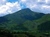
Tatamailau sometimes referred as Mount Ramelau, is the highest mountain in East Timor
and also of Timor
island at 2,963 m (9,721 ft). The mountain is located approximately 70 km (43 mi) of the capital Dili
in the district of Ainaro
. In Portuguese colonial days it was considered the highest mountain of Portugal
, and indeed of the whole Portuguese colonial empire, since the highest mountain of Portugal is of a more modest height. The name "Tatamailau" is Mambai
-origin, the local language and means "Grandfather of all". "Ramelau" is the name of the massif
of the mountain. The Tatamailau is dedicated to the Virgin Mary and the subject of an annual pilgrimage commemorating the Annunciation
of the Blessed Virgin Mary, on or around March 25. There is a three meter high statue of the Virgin Mary on the peak, which came from Italy and was erected during the Indonesian rule in 1997.
Tatamailau can be climbed from the town of Hato Bulico 3 km (1.9 mi) to the northeast or from the village of Aimeta 6 km (3.7 mi) to the north; there is about 910 m (2,990 ft) of climbing from either. The track from Hato Bulico to the summit is very well formed having originally been cut to create a pilgrimage trail to the Virgin Mary figure on the summit and was once negotiable by four wheel drive vehicle. A map is not required once on the track. The track is now very severely degraded with massive washouts requiring major detours to negotiate. Because the track was cut for vehicular access the constant gradient is monotonous, the poor engineering has caused major environmental damage and the route affords few views of note. The route from Aimeta is via a network of goat herders' tracks, it does not appear on current maps and a local guide is needed. However, the Aimeta track is varied, traverses unspoilt country, is extremely interesting with many unfolding mountain views and consequently presents by far the most enjoyable climb. A fit person should allow four hours from Hato Bulico to the summit, six hours from Aimeta, nine hours from Aimeta to Hato Bulico. Assume no water is available en route. There is no human habitation above Hato Bulico or Aimeta. It is possible to camp on the saddle below the summit in the dry season and experience the sunset and sunrise from the same location. The summit can freeze in the dry season; in the wet season the summit can be sufficiently cold, wet and windy to pose a risk of hypothermia.
Hato Bulico is a 1½ - 2 hour drive from Maubisse
on a sealed road but requires a four wheel drive. In the wet season it can be dangerous and periodically impassable but never for long. There is an excellent resting place at Hato Bulico close to the start of the track.
Aimeta can be reached from Letefoho in about 1½ hours. Shelter, but not food, may be negotiated at Aimeta with local assistance but it is advisable to arrive entirely self sufficient. The nearest accommodation is at the Saint Bakhita, Eraulo, via Vila Ermera
and an excellent, easy walk is to be had from there to Aimeta in about four hours. Horses for baggage can be hired at Aimeta and this is useful if camping on the summit or to assist stragglers. Aimeta can be a logistical challenge, which is why almost all summit bids are launched from Hato Bulico but it is possible, with care, for supporting transport to drive from Aimeta directly to Hato Bulico if the road is navigable otherwise, in the Wet season, via Gleno and Aileu in about five hours. An ideal route is to do the summit from Aimeta to Hato Bulico taking in both sides of the mountain; local assistance is essential for those without fluent Tetum and local knowledge.
East Timor
The Democratic Republic of Timor-Leste, commonly known as East Timor , is a state in Southeast Asia. It comprises the eastern half of the island of Timor, the nearby islands of Atauro and Jaco, and Oecusse, an exclave on the northwestern side of the island, within Indonesian West Timor...
and also of Timor
Timor
Timor is an island at the southern end of Maritime Southeast Asia, north of the Timor Sea. It is divided between the independent state of East Timor, and West Timor, belonging to the Indonesian province of East Nusa Tenggara. The island's surface is 30,777 square kilometres...
island at 2,963 m (9,721 ft). The mountain is located approximately 70 km (43 mi) of the capital Dili
Dili
Dili, spelled Díli in Portuguese, is the capital, largest city, chief port and commercial centre of East Timor.-Geography and Administration:Dili lies on the northern coast of Timor island, the easternmost of the Lesser Sunda Islands....
in the district of Ainaro
Ainaro
Ainaro is a town in East Timor, the capital of the Ainaro District, and is located in the southwest part of the country. The subdistrict has a population of approximately 12,000 people. It contains the small mountain town of Ainaro, the district capital, along with the villages of Soro, Maununo,...
. In Portuguese colonial days it was considered the highest mountain of Portugal
Portugal
Portugal , officially the Portuguese Republic is a country situated in southwestern Europe on the Iberian Peninsula. Portugal is the westernmost country of Europe, and is bordered by the Atlantic Ocean to the West and South and by Spain to the North and East. The Atlantic archipelagos of the...
, and indeed of the whole Portuguese colonial empire, since the highest mountain of Portugal is of a more modest height. The name "Tatamailau" is Mambai
Mambai
The Mambai are the second largest ethnic group in East Timor. Their language is also called Mambai and has ISO 639-3 code mgm.-People:...
-origin, the local language and means "Grandfather of all". "Ramelau" is the name of the massif
Massif
In geology, a massif is a section of a planet's crust that is demarcated by faults or flexures. In the movement of the crust, a massif tends to retain its internal structure while being displaced as a whole...
of the mountain. The Tatamailau is dedicated to the Virgin Mary and the subject of an annual pilgrimage commemorating the Annunciation
Annunciation
The Annunciation, also referred to as the Annunciation to the Blessed Virgin Mary or Annunciation of the Lord, is the Christian celebration of the announcement by the angel Gabriel to Virgin Mary, that she would conceive and become the mother of Jesus the Son of God. Gabriel told Mary to name her...
of the Blessed Virgin Mary, on or around March 25. There is a three meter high statue of the Virgin Mary on the peak, which came from Italy and was erected during the Indonesian rule in 1997.
Tatamailau can be climbed from the town of Hato Bulico 3 km (1.9 mi) to the northeast or from the village of Aimeta 6 km (3.7 mi) to the north; there is about 910 m (2,990 ft) of climbing from either. The track from Hato Bulico to the summit is very well formed having originally been cut to create a pilgrimage trail to the Virgin Mary figure on the summit and was once negotiable by four wheel drive vehicle. A map is not required once on the track. The track is now very severely degraded with massive washouts requiring major detours to negotiate. Because the track was cut for vehicular access the constant gradient is monotonous, the poor engineering has caused major environmental damage and the route affords few views of note. The route from Aimeta is via a network of goat herders' tracks, it does not appear on current maps and a local guide is needed. However, the Aimeta track is varied, traverses unspoilt country, is extremely interesting with many unfolding mountain views and consequently presents by far the most enjoyable climb. A fit person should allow four hours from Hato Bulico to the summit, six hours from Aimeta, nine hours from Aimeta to Hato Bulico. Assume no water is available en route. There is no human habitation above Hato Bulico or Aimeta. It is possible to camp on the saddle below the summit in the dry season and experience the sunset and sunrise from the same location. The summit can freeze in the dry season; in the wet season the summit can be sufficiently cold, wet and windy to pose a risk of hypothermia.
Hato Bulico is a 1½ - 2 hour drive from Maubisse
Maubisse
Maubisse is a town, suco and subdistrict in Ainaro District, East Timor. The suco has 4,947 inhabitants ....
on a sealed road but requires a four wheel drive. In the wet season it can be dangerous and periodically impassable but never for long. There is an excellent resting place at Hato Bulico close to the start of the track.
Aimeta can be reached from Letefoho in about 1½ hours. Shelter, but not food, may be negotiated at Aimeta with local assistance but it is advisable to arrive entirely self sufficient. The nearest accommodation is at the Saint Bakhita, Eraulo, via Vila Ermera
Ermera
Ermera is one of the districts of East Timor, located in the west-central part of the country. It has a population of 103,169 and an area of 746 km2. Its capital is Gleno, which is located 30 km to the southwest of the national capital, Dili...
and an excellent, easy walk is to be had from there to Aimeta in about four hours. Horses for baggage can be hired at Aimeta and this is useful if camping on the summit or to assist stragglers. Aimeta can be a logistical challenge, which is why almost all summit bids are launched from Hato Bulico but it is possible, with care, for supporting transport to drive from Aimeta directly to Hato Bulico if the road is navigable otherwise, in the Wet season, via Gleno and Aileu in about five hours. An ideal route is to do the summit from Aimeta to Hato Bulico taking in both sides of the mountain; local assistance is essential for those without fluent Tetum and local knowledge.