

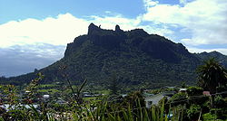
Mount Manaia
Encyclopedia
Whangarei
Whangarei, pronounced , is the northernmost city in New Zealand and the regional capital of Northland Region. Although commonly classified as a city, it is officially part of the Whangarei District, administered by the Whangarei District Council a local body created in 1989 to administer both the...
city on the Whangarei Heads
Whangarei Heads
Whangarei Heads is a locality and promontory on the northern side of the Whangarei Harbour in Northland, New Zealand. Whangarei is 29 km to the north west, and Ocean Beach is 8 km to the south east, with Taurikura between the two. Mount Manaia rises to 420 m to the east.Immediately to the...
peninsula.
Standing 420 metres, the summit offers outstanding views of the Marsden Point Oil Refinery
Marsden Point Oil Refinery
Marsden Point Oil Refinery is located at Marsden Point, Whangarei, Northland, New Zealand. It is the only oil refinery in New Zealand, and is operated by Refining NZ....
, Bream Bay
Bream Bay
Bream Bay is a locality and bay on the east coast of New Zealand. Captain James Cook named this area to the bay itself, but also the some surrounding locations, stretching north to Whangarei and southbound touching Mangawhai....
and the Hauraki Gulf
Hauraki Gulf
The Hauraki Gulf is a coastal feature of the North Island of New Zealand. It has a total area of 4000 km², and lies between the Auckland Region, the Hauraki Plains, the Coromandel Peninsula and Great Barrier Island...
to the south, Whangarei Harbour to the west and the Poor Knights Islands
Poor Knights Islands
The Poor Knights Islands are a group of islands off the east coast of the Northland Region of the North Island of New Zealand. They are located to the northeast of Whangarei, and lie offshore half way between Bream Head and Cape Brett. Uninhabited since the 1820s, they are a nature reserve and...
and Northland coast to the north.
Mt Manaia - along with Mt Lion, Bream Head
Bream Head
Bream Head is a promontory on the east coast of Northland in the North Island of New Zealand. Located at the end of a 30 kilometre-long peninsula, the head juts into the Pacific Ocean to the southeast of Whangarei...
and the Hen and Chicken Islands
Hen and Chicken Islands
The Hen and Chickens Islands lie to the east of the North Auckland Peninsula off the coast of northern New Zealand. They are located to the east of Bream Head and southeast of Whangarei....
, are the scattered remnants of a large, 50 kilometer diameter volcano that erupted with force 20 million years ago during the early miocene
Miocene
The Miocene is a geological epoch of the Neogene Period and extends from about . The Miocene was named by Sir Charles Lyell. Its name comes from the Greek words and and means "less recent" because it has 18% fewer modern sea invertebrates than the Pliocene. The Miocene follows the Oligocene...
period. Its jagged outline is similar to that of its neighbours and other volcanic outcrops in Northland that erupted in a similar period.
Today blanketed by native bush, Manaia's jagged peaks and steep bluffs are protected within a Department of Conservation reserve which features a well-maintained 1½ hour track to the summit.