
Mount Gee
Encyclopedia
Flinders Ranges
Flinders Ranges is the largest mountain range in South Australia, which starts approximately north west of Adelaide. The discontinuous ranges stretch for over from Port Pirie to Lake Callabonna...
within the Arkaroola Wilderness Sanctuary, and is part of the Mount Painter inlier. It was named after a mining warden, Lionel Gee.
Recently Mount Gee has come to prominence because of uranium exploration occurring in an area that was commonly (and mistakenly) believed to be protected from all mineral exploration.
Geography
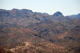
With its peak rising 600 metres above sea level Mount Gee is one of several peaks located in the visually spectacular and geologically significant range north-east of the Gammon Ranges and south of the Mawson PlateauMawson Plateau
thumb|right|230px|Typical Mawson Plateau terrain; rolling hills, with sparse vegetation interspersed with numerous eroded granite boulders.The Mawson Plateau is part of the northern Flinders Ranges, located on the Mount Freeling pastoral lease in South Australia, 140 km east of Lyndhurst and...
. Mount Gee was entered on the Register of the National Estate
Register of the National Estate
The Register of the National Estate is a listing of natural and cultural heritage places in Australia. The listing was initially compiled between 1976 and 2003 by the Australian Heritage Commission. The register is now maintained by the Australian Heritage Council...
in 1982 due to its "spectacular mass of quartz crystal and vughular, lining the cavities of crush breccias".
History
Mineral exploration in the Mount Painter region began in the 1860s with the discovery of copper at a number of sites in the region, including the Yudnamutana copper field and the Lady Buxton mine, and numerous small diggings throughout the Mount Painter area. Professor Sir Douglas Mawson first identified samples of TorbaniteTorbanite
Torbanite, also known as boghead coal, is a variety of fine-grained black oil shale. It usually occurs as lenticular masses, often associated with deposits of Permian coals. Torbanite is classified as lacustrine type oil shale....
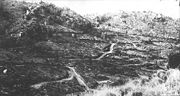
(Cu U Phosphate mineral) in samples brought to him in 1910 by the Greenwood brothers from what is now called Radium Ridge. Various syndicates were formed in 1911–1935 to try to exploit the Radium from Radium Ridge (immediately to the west and adjoining Mount Gee). During WW2 investigations in to the area of Mount Gee-Mount Painter were carried out by the Commonwealth Government, and the No.6 workings (see adjoining photo) was developed, as well as a number of workings in the East Painter Gorge (immediately to the north of Mount Gee-Mount Painter) and Yudnamutana Gorge. Sporadic exploration occurred during the 1950s adjacent to Mount Gee, culminating in the efforts of Exoil NL and Transoil NL during the late 1960s and early 1970s. It was during this exploration phase that the "Ridgetop" track was constructed. The numerous exploration tracks across the southern and north-eastern faces of Mt Gee were constructed by Exoil-Transoil at this time. Exploration ceased during the 1970s as a result of large uranium finds elsewhere and the "Three mine policy
Three mine policy
The three mine policy, introduced in 1984 and abandoned in 1996, was a policy of the government of Australia to limit the number of uranium mines in the country to three.-History:...
" policy introduced by the Federal Government in the early 1970s. CRA resumed exploration in the area during the early 1990s, focusing on the Streitberg Ridge and Armchair Basin areas, immediately to the north of Mount Gee, as well as other areas within the Arkaroola Sanctuary. Bonanza Gold Ltd pegged an exploration license over the Mt Gee area in the early 2000s. Several Exploration holes were drilled into the Mount Gee-Mount Painter area before Marathon Resources took over the project and intensified the exploration efforts, focusing once again on the southern and northeastern sides of Mount Gee, by opening up many of the (still existing) Exoil-Transoil tracks. None of the uranium deposits have been proven to be economic, although Marathon Resources claim that the Mount Gee deposit complies with a JORC inferred and indicated resource of 31,400 tonnes of U3O8, potentially the sixth largest known uranium deposit in Australia.
Tenure and legal status
The Arkaroola pastoral leasePastoral lease
A pastoral lease is Crown land that government allows to be leased, generally for the purposes of farming.-Australia:Pastoral leases exist in both Australian commonwealth law and state jurisdictions....
in which Mount Gee is located was purchased by Reginald and Griselda Sprigg in 1967 for the purposes of "wildlife preservations and conservation of the environment", with this objective being recognised by the South Australian Government initially in 1969 and again (after a long period of limbo) in 1996 with the property being granted official status as a wilderness sanctuary.
This status was reinforced with the inclusion of the Mount Gee area within the "Environmental Class A Zone" defined in the South Australian Development Plan, which has as its objectives: "The conservation of the natural character and environment of the area" and "The protection of the landscape from damage by mining operations and exploring
for new resources... Mining operations should not take place in the Environmental Class A Zone unless the deposits are of such paramount importance and their exploitation is in the highest national or State interest that all other environment, heritage or conservation considerations may be overridden. Deposits which may potentially have the required degree of significance have been identified in the following localities only:
the western face of the Heysen. Ranges [sic]; portion of the Moralana Valley; portion of the Mount Hack and Mount Uro areas; portion of the Stirrup Iron Range; portion of the east Gammons and the Mount Painter-Freeling Heights area [my emphasis]." which includes the Mt.Painter and Mt. Gee areas.
The area is still not protected from mineral exploration nor mining, as under the S.A. Mining Act (1971 and amendments) none of the current classes of so-called protection have any status.
Recent developments
Mining company Marathon Resources gave notice on or around 14 September 2007 of its intention to apply for a mining lease allowing extraction of uranium ore from Mount Gee. To satisfy the environmental objectives cited above the application forwarded by the proponent indicates an underground mine (as opposed to open-cut) which would be serviced via a tunnel allowing access to infrastructure and processing facilities located away from the immediate vicinity of the Arkaroola area, on the plains near Lake FromeLake Frome
Lake Frome is a large endorheic lake in South Australia, east of the Northern Flinders Ranges. It is a large, shallow, unvegetated salt pan, 100 km long and 40 km wide, lying mostly below sea level and having a total surface area of 259,615 hectares...
. The proposal is opposed by the owners and operators of Arkaroola Wilderness Sancturary in which the proposed mine would be located as well as conservation and anti-nuclear groups.
In January 2008 the owners of Arkaroola Wilderness Sanctuary were alerted to environmental contamination at Mount Gee. An investigation by the South Australian Government found that around 22,800 plastic and calico bags containing non-radioactive exploration samples, drilling material, cardboard and paper waste, plastic jars, PVC pipe, packing and other material were buried by the drilling contractor in two large trenches approximately 35 metres long x 4 metres wide x 2.7 metres deep. In addition Marathon Resources have admitted in a subsequent Rectification Plan the company was required to submit that twenty drums of samples were buried in a nearby site, as well as various food packaging and personal protective equipment waste at another nearby site. There is also evidence that a rare sample of fluorite
Fluorite
Fluorite is a halide mineral composed of calcium fluoride, CaF2. It is an isometric mineral with a cubic habit, though octahedral and more complex isometric forms are not uncommon...
has also been removed from the side of Mount Gee, with the exact circumstances of this removal and the present location of the fluorite sample unclear.. There is no evidence to suggest that Marathon or its contractors were responsible for this. The removal of mineral specimens from the Mount Gee area has been ongoing since before the Arkaroola Sanctuary opened in the late 1960s, and collectors have prised prized examples of green and purple banded fluorite, Fluorite pseudomorphs, "nailhole Quartz" and "Cowstitite" from the outcrops of Mount Gee, aided by the continued ease of access via the well-maintained "Ridgetop Track" 4WD tourist route (see photo above).
In response to this investigation the SA Minister for Mineral Resources Development found this method of waste disposal constituted a "significant breach of exploration licence conditions" and suspended the exploration licence granted to Marathon Resources to conduct uranium exploration on Mount Gee. However, in October 2009 the Government granted a brand new 12 month exploration licence to Marathon Resources. On 27 October 2009, the Rann Government released a draft management Plan for the Northern Flinders Ranges, called 'Seeking in Balance'. According to its opponents this Plan allows for mining activity right in the heart of the Arkaroola Sanctuary, including Mount Gee.
Since the exploration Licence was re-granted, Marathon Mining have conducted low-impact exploration, including stream sediment sampling and some geophysics. Drillng has not resumed.
External links
- Arkaroola Wilderness Sanctuary's Mount Gee web page
- Marathon Resources Pty Ltd website
- An interview with both the mine proponent and the owner/operator of Arkaroola Wilderness Sanctuary is available from the Australian Broadcasting Corporation's "Bush Telegraph" program web site.