
Mount Barney
Encyclopedia
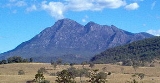
Mount Barney is a mountain
located in south-east Queensland
, Australia
. It lies approximately 130 kilometres south-west of Brisbane
, not far from the Queensland - New South Wales border, and forms part of the McPherson Range
. It is a popular destination for bushwalkers and campers. Mount Barney is the fourth highest mountain in Queensland and is often regarded as one of the most impressive parts of the Scenic Rim
. The mountain consists of two main peaks, (East Peak and the slightly higher West Peak), and a number of smaller subsidiary peaks. East Peak is probably the most popular destination for bushwalkers.
The closest town is Rathdowney
. Mount Barney is surrounded by a number of other mountains including Mount Ballow, Mount May, Mount Ernest, Mount Maroon
and Mount Lindesay. Logan River
has its headwaters on the mountain.
was established to protect the natural heritage surrounding the peak. Mount Barney was included in the Central Eastern Rainforest Reserves
in 1994. The Antarctic Beech
can be found of the upper slopes of both Mount Barney and in the rainforest
of nearby Mount Ballow. Important animal species found on the mountain include platypus
, rock wallabies and Coxen's fig parrot. Heath vegetation on the mountain provides habitat for a colony of the endangered Eastern Bristlebird
.
that formed below the surface and subsequently intruded into the overlaying sandstone
. Erosion has stripped away the sandstone leaving the mountain's twin peaks.
The first Europe
an to climb Mount Barney was Captain Patrick Logan
, who reached the East Peak summit via the now named Logans Ridge, during an exploring expedition in 1828. Accounts of the climb were written by botanists Charles Fraser
and Allan Cunningham
, who accompanied Logan for part of the ascent.
Historical records suggest that Europeans probably began bushwalking at Mount Barney for recreation in about the 1880s, when the region became more closely settled. During the first decade or so of the 20th century, the peak became popular with a small number of self-styled 'mountaineers', such as Boonah
school teachers Harry Johns (1877-1943) and William Gaylard (1880-1930), Ipswich
Technical College Principal R.A. Wearne (1870-1932), and some of the selectors who lived close by, such as the Doherty family at 'Lilydale'. However it was probably not until the early 1930s, with the formation of groups such as the National Parks Association, and the appearance of a new breed of outdoor adventurers such as Bert Salmon (1899-1982), who made the first recorded ascent of Leaning Peak in 1932, Cliff Wilson (who was probably the first European to climb all of the Mount Barney peaks and lesser pinnacles) and Arthur Groom
(1904-1953), and also botanists such as Cyril White (1890-1950) and Lindsay Smith (1917-1970), that bushwalkers began visiting the peak in numbers, and even then, much of Mount Barney remained unexplored until the late 1940s and early 1950s, when groups such as the University of Queensland
Bushwalking Club, and the Brisbane Bushwalkers began making regular bushwalking and camping trips to the peak.
in the creek at the saddle between East and West Peak, but elsewhere on the mountain, away from the creeks, water is often difficult to find. In addition to the mountain itself, Mount Barney Creek (to the West) and Cronans Creek (to the South-East), the two main creek systems which ring Mount Barney, offer plenty of scope for walking and camping, particularly in the warmer months. Note though that the creeks are prone to flash flood
ing after heavy rainfall, and that they are potentially quite dangerous at times of high flow.
To date, Mount Barney has attracted only a relatively small number of rock-climbers
, perhaps due to the long walk in times and access difficulties. So far, local climbers have generally agreed that the peak should remain "trad only" (ie. no bolts). The spectacular East Face was first climbed in 1966, and over the years a number of other routes have been put up in the vicinity of Leaning Peak and Isolated Peak. More recently, bouldering (ground-level climbing) has become popular in Mount Barney Creek upstream from the Lower Portals camping area.
Mountain
Image:Himalaya_annotated.jpg|thumb|right|The Himalayan mountain range with Mount Everestrect 58 14 160 49 Chomo Lonzorect 200 28 335 52 Makalurect 378 24 566 45 Mount Everestrect 188 581 920 656 Tibetan Plateaurect 250 406 340 427 Rong River...
located in south-east Queensland
Queensland
Queensland is a state of Australia, occupying the north-eastern section of the mainland continent. It is bordered by the Northern Territory, South Australia and New South Wales to the west, south-west and south respectively. To the east, Queensland is bordered by the Coral Sea and Pacific Ocean...
, Australia
Australia
Australia , officially the Commonwealth of Australia, is a country in the Southern Hemisphere comprising the mainland of the Australian continent, the island of Tasmania, and numerous smaller islands in the Indian and Pacific Oceans. It is the world's sixth-largest country by total area...
. It lies approximately 130 kilometres south-west of Brisbane
Brisbane
Brisbane is the capital and most populous city in the Australian state of Queensland and the third most populous city in Australia. Brisbane's metropolitan area has a population of over 2 million, and the South East Queensland urban conurbation, centred around Brisbane, encompasses a population of...
, not far from the Queensland - New South Wales border, and forms part of the McPherson Range
McPherson Range
The McPherson Range is an extensive mountain range, a spur of the Great Dividing Range, heading in an easterly direction from near Wallangarra to the Pacific Ocean coastline. It forms part of the Scenic Rim on the border between the states of New South Wales and Queensland. Further west of the...
. It is a popular destination for bushwalkers and campers. Mount Barney is the fourth highest mountain in Queensland and is often regarded as one of the most impressive parts of the Scenic Rim
Scenic Rim
The Scenic Rim is a group of forested mountain ranges of the Great Dividing Range straddling the border between south-eastern Queensland and north-eastern New South Wales, Australia.-Description:...
. The mountain consists of two main peaks, (East Peak and the slightly higher West Peak), and a number of smaller subsidiary peaks. East Peak is probably the most popular destination for bushwalkers.
The closest town is Rathdowney
Rathdowney, Queensland
Rathdowney is a small town in south-eastern Queensland, Australia. It is on the Mount Lindesay Highway 32 km south of Beaudesert at the base of the McPherson Range. It is located in the Scenic Rim Local Government Area. At the 2006 census, Rathdowney had a population of 198.The town was named...
. Mount Barney is surrounded by a number of other mountains including Mount Ballow, Mount May, Mount Ernest, Mount Maroon
Mount Maroon
Mount Maroon is a mountain in South East Queensland that is part of the McPherson Range. The mountain rises to above sea level about 12 km west of Rathdowney....
and Mount Lindesay. Logan River
Logan River
The Logan River is a river in South East Queensland. The catchment is dominated by urban and agricultural land use. Near the river mouth are mangrove forests and a number of aquaculture farms.-History:...
has its headwaters on the mountain.
Natural heritage
In 1947, the Mount Barney National ParkMount Barney National Park
Mount Barney National Park is a national park in Queensland , 90 km southwest of Brisbane. It amalgamated the adjacent Mount Lindesay National Park in 1980. It is part of the Scenic Rim Important Bird Area, identified as such by BirdLife International because of its importance in the conservation...
was established to protect the natural heritage surrounding the peak. Mount Barney was included in the Central Eastern Rainforest Reserves
Central Eastern Rainforest Reserves
The Gondwana Rainforests of Australia formerly known as the Central Eastern Rainforest Reserves, are the most extensive area of subtropical rainforest in the world...
in 1994. The Antarctic Beech
Nothofagus moorei
Nothofagus moorei, is an important Gondwana relict of the rainforests of the southern hemisphere. It occurs in wet, fire free areas at high altitude in eastern Australia....
can be found of the upper slopes of both Mount Barney and in the rainforest
Rainforest
Rainforests are forests characterized by high rainfall, with definitions based on a minimum normal annual rainfall of 1750-2000 mm...
of nearby Mount Ballow. Important animal species found on the mountain include platypus
Platypus
The platypus is a semi-aquatic mammal endemic to eastern Australia, including Tasmania. Together with the four species of echidna, it is one of the five extant species of monotremes, the only mammals that lay eggs instead of giving birth to live young...
, rock wallabies and Coxen's fig parrot. Heath vegetation on the mountain provides habitat for a colony of the endangered Eastern Bristlebird
Eastern Bristlebird
The Eastern Bristlebird is a species of bird in the Bristlebird family Dasyornithidae. It is endemic to Australia. Its natural habitats are temperate forests, temperate shrubland, and temperate grassland...
.
Geology
The dome-shaped mass is composed of granophyreGranophyre
Granophyre is a subvolcanic rock that contains quartz and alkali feldspar in characteristic angular intergrowths such as those in the accompanying image....
that formed below the surface and subsequently intruded into the overlaying sandstone
Sandstone
Sandstone is a sedimentary rock composed mainly of sand-sized minerals or rock grains.Most sandstone is composed of quartz and/or feldspar because these are the most common minerals in the Earth's crust. Like sand, sandstone may be any colour, but the most common colours are tan, brown, yellow,...
. Erosion has stripped away the sandstone leaving the mountain's twin peaks.
History
Mount Barney has held a special significance for local Aboriginal people for millennia, and it features prominently in a number of their stories. For Aboriginal people the peak has traditionally been regarded as a place to avoid.The first Europe
Europe
Europe is, by convention, one of the world's seven continents. Comprising the westernmost peninsula of Eurasia, Europe is generally 'divided' from Asia to its east by the watershed divides of the Ural and Caucasus Mountains, the Ural River, the Caspian and Black Seas, and the waterways connecting...
an to climb Mount Barney was Captain Patrick Logan
Patrick Logan
Captain Patrick Logan was the commandant of the Moreton Bay penal colony from 1826 until his death in 1830. He is thought to have been killed by Aboriginal Australians who objected to him entering their lands...
, who reached the East Peak summit via the now named Logans Ridge, during an exploring expedition in 1828. Accounts of the climb were written by botanists Charles Fraser
Charles Fraser
Charles Fraser may refer to:* Charles Fraser , botanist and explorer of Australia* Charles Fraser , ice hockey player* Charles Fraser , missionary with the Scottish Missionary Society to Russian Tatary...
and Allan Cunningham
Allan Cunningham (botanist)
Allan Cunningham was an English botanist and explorer, primarily known for his travels in New South Wales to collect plants.- Early life :...
, who accompanied Logan for part of the ascent.
Historical records suggest that Europeans probably began bushwalking at Mount Barney for recreation in about the 1880s, when the region became more closely settled. During the first decade or so of the 20th century, the peak became popular with a small number of self-styled 'mountaineers', such as Boonah
Boonah, Queensland
Boonah is a town in south eastern Queensland, Australia. At the 2006 census, the town had a population of 2,285. The area produces vegetables for the nearby Brisbane Markets notably carrots, potatoes, and cereal crops. Beef, pork and timber are also produced locally.The town is positioned near the...
school teachers Harry Johns (1877-1943) and William Gaylard (1880-1930), Ipswich
Ipswich, Queensland
Ipswich is a city in South-East Queensland, Australia. Situated along the Bremer River Valley approximately 40 kilometres away from the state's capital Brisbane. The suburb by the same name forms the city's Central Business District and administrative centre...
Technical College Principal R.A. Wearne (1870-1932), and some of the selectors who lived close by, such as the Doherty family at 'Lilydale'. However it was probably not until the early 1930s, with the formation of groups such as the National Parks Association, and the appearance of a new breed of outdoor adventurers such as Bert Salmon (1899-1982), who made the first recorded ascent of Leaning Peak in 1932, Cliff Wilson (who was probably the first European to climb all of the Mount Barney peaks and lesser pinnacles) and Arthur Groom
Arthur Groom (Australian writer)
Arthur Groom was an Australian writer, conservationist, journalist and photographer, the son of Arthur Champion Groom.-Early career:...
(1904-1953), and also botanists such as Cyril White (1890-1950) and Lindsay Smith (1917-1970), that bushwalkers began visiting the peak in numbers, and even then, much of Mount Barney remained unexplored until the late 1940s and early 1950s, when groups such as the University of Queensland
University of Queensland
The University of Queensland, also known as UQ, is a public university located in state of Queensland, Australia. Founded in 1909, it is the oldest and largest university in Queensland and the fifth oldest in the nation...
Bushwalking Club, and the Brisbane Bushwalkers began making regular bushwalking and camping trips to the peak.
Bushwalking
There are a dozen or so established bushwalking routes up Mount Barney, however none of them are easy. All the routes require a reasonable level of fitness, and many require advanced route-finding and rock-scrambling skills. Only South Ridge ("Peasants Ridge") can be recommended to less experienced walkers. Whilst the steep route up Logans Ridge to the East Peak summit is often considered to be the most spectacular, all the routes have their attractions. As a rough guide, a trip to East Peak via one of the more direct routes will generally take 8–9 hours return when carrying a day pack. There is usually a flow of drinkable waterDrinking water
Drinking water or potable water is water pure enough to be consumed or used with low risk of immediate or long term harm. In most developed countries, the water supplied to households, commerce and industry is all of drinking water standard, even though only a very small proportion is actually...
in the creek at the saddle between East and West Peak, but elsewhere on the mountain, away from the creeks, water is often difficult to find. In addition to the mountain itself, Mount Barney Creek (to the West) and Cronans Creek (to the South-East), the two main creek systems which ring Mount Barney, offer plenty of scope for walking and camping, particularly in the warmer months. Note though that the creeks are prone to flash flood
Flash flood
A flash flood is a rapid flooding of geomorphic low-lying areas—washes, rivers, dry lakes and basins. It may be caused by heavy rain associated with a storm, hurricane, or tropical storm or meltwater from ice or snow flowing over ice sheets or snowfields...
ing after heavy rainfall, and that they are potentially quite dangerous at times of high flow.
To date, Mount Barney has attracted only a relatively small number of rock-climbers
Rock climbing
Rock climbing also lightly called 'The Gravity Game', is a sport in which participants climb up, down or across natural rock formations or artificial rock walls. The goal is to reach the summit of a formation or the endpoint of a pre-defined route without falling...
, perhaps due to the long walk in times and access difficulties. So far, local climbers have generally agreed that the peak should remain "trad only" (ie. no bolts). The spectacular East Face was first climbed in 1966, and over the years a number of other routes have been put up in the vicinity of Leaning Peak and Isolated Peak. More recently, bouldering (ground-level climbing) has become popular in Mount Barney Creek upstream from the Lower Portals camping area.
See also
- List of mountains of Australia
- List of volcanoes in Australia