
Morro da Igreja
Encyclopedia
Urubici
Urubici is a southern Brazilian city located in the state of Santa Catarina.-Neighboring Cities:Some of the nearest cities are São Joaquim-60 km , Lages, Tubarão, and Criciúma.-Climate:...
, a municipality of the Santa Catarina
Santa Catarina (state)
Santa Catarina is a state in southern Brazil with one of the highest standards of living in Latin America. Its capital is Florianópolis, which mostly lies on the Santa Catarina Island. Neighbouring states are Rio Grande do Sul to the south and Paraná to the north. It is bounded on the east by...
state, in southern
Southern Region, Brazil
The South Region of Brazil is one of the five regions of Brazil. It includes the states of Paraná, Santa Catarina and Rio Grande do Sul and covers 576,409.6 km ², being the smallest portion of the country...
Brazil
Brazil
Brazil , officially the Federative Republic of Brazil , is the largest country in South America. It is the world's fifth largest country, both by geographical area and by population with over 192 million people...
. Its latitude
Latitude
In geography, the latitude of a location on the Earth is the angular distance of that location south or north of the Equator. The latitude is an angle, and is usually measured in degrees . The equator has a latitude of 0°, the North pole has a latitude of 90° north , and the South pole has a...
is 28º07'31" S and its longitude
Longitude
Longitude is a geographic coordinate that specifies the east-west position of a point on the Earth's surface. It is an angular measurement, usually expressed in degrees, minutes and seconds, and denoted by the Greek letter lambda ....
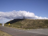
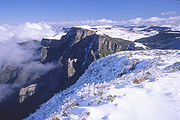
is 49º29'38" W, with an elevation of 1,822 metres (5,977 feet), the highest inhabited point and the second most elevated of this state. This peak registered the lowest (unofficial) temperature in Brazil: -17.8°C (0°F), on June 29, 1996. It is considered the coldest place in this country; tourism is popular in the winter, when snowfalls can occur.
Brazilian Air Force
The Brazilian Air Force is the air branch of the Brazilian Armed Forces and one of the three national uniformed services. The FAB was formed when the Army and Navy air branch were merged into a single military force initially called "National Air Forces"...
has a military base on the summit equipped with radars and radio relay
Microwave transmission
Microwave transmission refers to the technology of transmitting information or power by the use of radio waves whose wavelengths are conveniently measured in small numbers of centimeters; these are called microwaves. This part of the radio spectrum ranges across frequencies of roughly...
s for air traffic control
Area Control Center
In air traffic control, an Area Control Center , also known as a Center, is a facility responsible for controlling instrument flight rules aircraft en route in a particular volume of airspace at high altitudes between airport approaches and departures...
(CINDACTA
CINDACTA
The air traffic control centers of Brazil are known by the acronym CINDACTA, or "Centro Integrado de Defesa Aérea e Controle de Tráfego Aéreo...
) of the Brazilian Southern Region.
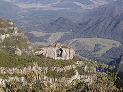
There is a curious natural formation in this area, called Pedra Furada
Pedra Furada (Santa Catarina)
Pedra Furada is a natural formation located in the municipality of Urubici, state of Santa Catarina, Southern Brazil.It can be spotted from the summit of a mountain named Morro da Igreja....
(literally Drilled Stone), and it can be spotted from the peak.
See also
- Morro da Boa VistaMorro da Boa VistaMorro da Boa Vista is the highest mountain in the Brazilian state of Santa Catarina, the highest at Serra Geral and the third highest in Southern Brazil, after Pico Paraná and Pico Caratuva, at . The peak can get quite cold during winter, with the possibility of snowfall....
, the highest peak of Santa Catarina. - Serra do Rio do RastroSerra do Rio do RastroSerra do Rio do Rastro is a mountain range located in the southeast of the state of Santa Catarina, Southern Brazil. It is crossed by the road SC-438, with remarkable landscapes and deep crags....