
Mopti Region
Encyclopedia
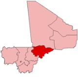
Mopti is the fifth administrative region of Mali
, covering 79,017 km². Its capital is the city of Mopti
.
to the southwest, and Burkina Faso
to the southeast.
The population is 2,037,330 including Bozo
s, Songhai, Dogon
, Fula
s, and Bambara.
The Niger River
crosses the region, and is joined by the Bani, its tributary, at the city of Mopti.
The region is separated into several areas: the Niger delta
around Mopti, the Bandiagara
cliffs and the plain of Bankass
along the Burkina Faso frontier. Mount Hombori
, the highest point in Mali at 1153 meters, is in the Mopti Region, near the city
of the same name.
In terms of its climate, Mopti Region is considered part of the Sahel
.
The largest towns of the region are Mopti, Sévaré
, Djenné
, Bandiagara
, Bankass
and Youwarou
.
and Ségou
to the west and Tombouctou
and Gao
to the east.
The region is well-irrigate
d and its agriculture
is well-developed, with particularly successful fishing
. Mopti serves as an important commercial crossroads between Mali's north, south and bordering nations. Tourism is also well-developed, notably in the cities of Djenné and Mopti (the former of which boasts the Great Mosque of Djenné
, the largest mud structure in the world) and in Dogon
country.
village named Sanga, had long been inhabited, rapid expansion began under Seku Amadu's Massina Empire
around 1820. Expansion continued under the Toucouleur Empire
of El Hadj Umar Tall
as well as the French
colonial
administration.
, Dogon, Songhai, Bozo
and Fula
.
Both the city of Djenné and the Bandiagara cliffs have been named World Heritage Site
s by UNESCO
.
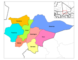 Mopti is divided into 8 Cercles
encompassing 108 communes:
Mali
Mali , officially the Republic of Mali , is a landlocked country in Western Africa. Mali borders Algeria on the north, Niger on the east, Burkina Faso and the Côte d'Ivoire on the south, Guinea on the south-west, and Senegal and Mauritania on the west. Its size is just over 1,240,000 km² with...
, covering 79,017 km². Its capital is the city of Mopti
Mopti
Mopti is a city at the confluence of the Niger and the Bani in Mali, between Timbuktu and Ségou. The city lies on three islands linked by dykes: the New Town, the Old Town and Medina Coura. As a result it is sometimes known as the "Venice of Mali".-History:The city of Mopti derives its name from...
.
Geography
Mopti Region is bordered by Tombouctou Region to the north, Ségou RegionSégou Region
Ségou is the fourth most populous administrative region in Mali, whose capital is the town of Ségou.-Geography:Situated at the center of Mali, Ségou Region covers 64,947 km²...
to the southwest, and Burkina Faso
Burkina Faso
Burkina Faso – also known by its short-form name Burkina – is a landlocked country in west Africa. It is surrounded by six countries: Mali to the north, Niger to the east, Benin to the southeast, Togo and Ghana to the south, and Côte d'Ivoire to the southwest.Its size is with an estimated...
to the southeast.
The population is 2,037,330 including Bozo
Bozo people
The Bozo are a West African ethnic group located predominantly along the Niger River in Mali. The name Bozo is thought to derive from Bambara bo-so, 'Bamboo house'; the people accept it as referring to the whole of the ethnic group but use more specific clan names such as Sorogoye, Hain, and Tieye...
s, Songhai, Dogon
Dogon people
The Dogon are an ethnic group living in the central plateau region of Mali, south of the Niger bend near the city of Bandiagara in the Mopti region. The population numbers between 400,000 and 800,000 The Dogon are best known for their religious traditions, their mask dances, wooden sculpture and...
, Fula
Fula people
Fula people or Fulani or Fulbe are an ethnic group spread over many countries, predominantly in West Africa, but found also in Central Africa and Sudanese North Africa...
s, and Bambara.
The Niger River
Niger River
The Niger River is the principal river of western Africa, extending about . Its drainage basin is in area. Its source is in the Guinea Highlands in southeastern Guinea...
crosses the region, and is joined by the Bani, its tributary, at the city of Mopti.
The region is separated into several areas: the Niger delta
River delta
A delta is a landform that is formed at the mouth of a river where that river flows into an ocean, sea, estuary, lake, reservoir, flat arid area, or another river. Deltas are formed from the deposition of the sediment carried by the river as the flow leaves the mouth of the river...
around Mopti, the Bandiagara
Bandiagara
Bandiagara is a city in the Dogon region of Mali in Africa. The name translates roughly to "large eating bowl"—referring to the communal bowl meals are served in....
cliffs and the plain of Bankass
Bankass
Bankass is a city located in the Dogon territory of Mali's Mopti Region.Bankass is the capital of its Cercle, which encompasses seven communes: Bankass, Baye, Diallassagou, Kanibonzon, Ouenkoro, Segue, and Sokoura....
along the Burkina Faso frontier. Mount Hombori
Mount Hombori
Mount Hombori is a mountain in Mali's Mopti Region, near the town of Hombori. At 1,153 meters, it is the highest point in Mali.Mount Hombori is a significant archaeological site, with caves inhabited more than 2,000 years ago....
, the highest point in Mali at 1153 meters, is in the Mopti Region, near the city
Hombori
Hombori is a town in Mali, lying between Mopti and Gao on the slopes of the Hombori Tondo mesa. It is in the traditional region of Gourma, and the current région administrative de Mopti, Cercle of Douentza....
of the same name.
In terms of its climate, Mopti Region is considered part of the Sahel
Sahel
The Sahel is the ecoclimatic and biogeographic zone of transition between the Sahara desert in the North and the Sudanian Savannas in the south.It stretches across the North African continent between the Atlantic Ocean and the Red Sea....
.
The largest towns of the region are Mopti, Sévaré
Sévaré
Sévaré is a town in the Mopti Region of Mali. It is a crossroads town of about 40,000 situated about 10 km. southeast of Mopti and 10 km. south of Fatoma, the old capital of Kunaari...
, Djenné
Djenné
Djenné is an Urban Commune and town in the Inland Niger Delta region of central Mali. In the 2009 census the commune had a population of 32,944. Administratively it is part of the Mopti Region....
, Bandiagara
Bandiagara
Bandiagara is a city in the Dogon region of Mali in Africa. The name translates roughly to "large eating bowl"—referring to the communal bowl meals are served in....
, Bankass
Bankass
Bankass is a city located in the Dogon territory of Mali's Mopti Region.Bankass is the capital of its Cercle, which encompasses seven communes: Bankass, Baye, Diallassagou, Kanibonzon, Ouenkoro, Segue, and Sokoura....
and Youwarou
Youwarou
Youwarou is a village and commune and seat of the Cercle of Youwarou in the Mopti Region of Mali. As of 1998 the commune had a population of 14,767.-References:...
.
Transportation and Economy
An airport at Mopti provides air service for the region, while the Niger River provides transportation to KoulikoroKoulikoro
Koulikoro is a city in Mali. The capital of the Koulikoro Region, Koulikoro is located on banks of the Niger River, from Mali's capital Bamako....
and Ségou
Ségou
Ségou is a city in south-central Mali, lying northeast of Bamako on the River Niger, in the region of Ségou. It was founded by the Bozo people, on a site about from the present town...
to the west and Tombouctou
Tombouctou
Tombouctou may be:* Tombouctou Region in northern Mali* The French name for the city of Timbuktu, which gives its name to the region...
and Gao
Gao
Gao is a town in eastern Mali on the River Niger lying ESE of Timbuktu. Situated on the left bank of the river at the junction with the Tilemsi valley, it is the capital of the Gao Region and had a population of 86,663 in 2009....
to the east.
The region is well-irrigate
Irrigation
Irrigation may be defined as the science of artificial application of water to the land or soil. It is used to assist in the growing of agricultural crops, maintenance of landscapes, and revegetation of disturbed soils in dry areas and during periods of inadequate rainfall...
d and its agriculture
Agriculture
Agriculture is the cultivation of animals, plants, fungi and other life forms for food, fiber, and other products used to sustain life. Agriculture was the key implement in the rise of sedentary human civilization, whereby farming of domesticated species created food surpluses that nurtured the...
is well-developed, with particularly successful fishing
Fishing
Fishing is the activity of trying to catch wild fish. Fish are normally caught in the wild. Techniques for catching fish include hand gathering, spearing, netting, angling and trapping....
. Mopti serves as an important commercial crossroads between Mali's north, south and bordering nations. Tourism is also well-developed, notably in the cities of Djenné and Mopti (the former of which boasts the Great Mosque of Djenné
Great Mosque of Djenné
The Great Mosque of Djenné is the largest mud brick or adobe building in the world and is considered by many architects to be the greatest achievement of the Sudano-Sahelian architectural style, with definite Islamic influences. The mosque is located in the city of Djenné, Mali on the flood plain...
, the largest mud structure in the world) and in Dogon
Dogon people
The Dogon are an ethnic group living in the central plateau region of Mali, south of the Niger bend near the city of Bandiagara in the Mopti region. The population numbers between 400,000 and 800,000 The Dogon are best known for their religious traditions, their mask dances, wooden sculpture and...
country.
History
Though Mopti's location, once a BozoBozo people
The Bozo are a West African ethnic group located predominantly along the Niger River in Mali. The name Bozo is thought to derive from Bambara bo-so, 'Bamboo house'; the people accept it as referring to the whole of the ethnic group but use more specific clan names such as Sorogoye, Hain, and Tieye...
village named Sanga, had long been inhabited, rapid expansion began under Seku Amadu's Massina Empire
Massina Empire
The Massina Empire was an early nineteenth-century Fulbe Jihad state centered in the Macina and Inner Niger Delta area of what is now the Mopti and Ségou Regions of Mali...
around 1820. Expansion continued under the Toucouleur Empire
Toucouleur Empire
The Toucouleur Empire was founded in the nineteenth century by El Hadj Umar Tall of the Toucouleur people, in part of present-day Mali....
of El Hadj Umar Tall
Umar Tall
El Hadj Umar ibn Sa'id Tall , , born in what is now actual Senegal was a West African political leader, Islamic scholar, and Toucouleur military commander who founded a brief empire encompassing much of what is now Guinea, Senegal, and Mali.-Name:Umar Tall's name is spelled variously: in...
as well as the French
France
The French Republic , The French Republic , The French Republic , (commonly known as France , is a unitary semi-presidential republic in Western Europe with several overseas territories and islands located on other continents and in the Indian, Pacific, and Atlantic oceans. Metropolitan France...
colonial
Colonialism
Colonialism is the establishment, maintenance, acquisition and expansion of colonies in one territory by people from another territory. It is a process whereby the metropole claims sovereignty over the colony and the social structure, government, and economics of the colony are changed by...
administration.
Culture
The region is a melting pot, made up of various ethnic groups which live in harmony with one another. Common languages of the area include BambaraBambara language
Bambara, more correctly known as Bamanankan , its designation in the language itself , is a language spoken in Mali by as many as six million people...
, Dogon, Songhai, Bozo
Bozo languages
Bozo is spoken by the Bozo, the principal fishing people of the Inner Niger Delta in Mali. According to the 2000 census, the Bozo people number about 132,100. The Bozo dialect cluster is often considered to be one language, but there is quite a bit of diversity...
and Fula
Fula language
The Fula or Fulani language is a language of West Africa. It is spoken as a first language by the and related groups from Senegambia and Guinea to Cameroon and Sudan...
.
Both the city of Djenné and the Bandiagara cliffs have been named World Heritage Site
World Heritage Site
A UNESCO World Heritage Site is a place that is listed by the UNESCO as of special cultural or physical significance...
s by UNESCO
UNESCO
The United Nations Educational, Scientific and Cultural Organization is a specialized agency of the United Nations...
.
Administrative subdivision
Cercles of Mali
A cercle is the second level administrative unit in Mali. Mali is divided into eight regions and one capital district . These subdivisions bear the name of their principal city. The regions are divided into 49 cercles....
encompassing 108 communes:
- Bandiagara CercleBandiagara CercleBandiagara Cercle is an administrative subdivision of the Mopti Region of Mali. The administrative center is the town of Bandiagara.The cercle is divided into 21 communes:*Bandiagara*Bara Sara*Borko*Dandoli*Diamnati*Dogani Béré...
- Bankass CercleBankass CercleBankass Cercle is an administrative subdivision of the Mopti Region of Mali. The administrative center is at the town of Bankass.The Cercle is divided into 12 rural communes:*Bankass*Baye*Diallassagou*Dimbal Habé*Kani Bonzon...
- Djenné CercleDjenné CercleDjenné Cercle is an administrative subdivision of the Mopti Region of Mali. The administrative center is the town of Djenné. In the 2009 census the cercle had a population of 207,260 people.-Administrative subdivisions:...
- Douentza CercleDouentza CercleDouentza Cercle is an administrative subdivision of the Mopti Region of Mali. The administrative center is the town of Douentza.The cercle is divided into 15 communes:*Dallah*Dangol-Boré*Débéré*Dianwéli*Djaptodji*Douentza*Gandamia...
- Koro CercleKoro CercleKoro Cercle is an administrative subdivision of the Mopti Region of Mali. The administrative center is the town of Koro.The cercle is divided into 16 communes:*Bamba*Barapiréli*Bondo*Diankabou*Dinangourou*Dioungani*Dougouténé I*Dougouténé II*Kassa...
- Mopti CercleMopti CercleMopti Cercle is an administrative subdivision of the Mopti Region of Mali. The administrative center is the town of Mopti.The cercle is divided into 15 communes:*Bassirou*Borondougou*Dialloubé*Fatoma*Konna*Korombana*Koubaye*Kounari...
- Tenenkou CercleTenenkou CercleTénenkou Cercle is an administrative subdivision of the Mopti Region of Mali. Its seat is the town of Ténenkou, which is also its largest town. The cercle is divided into communes.Ténenkou Cercle contains the following communes:* Diafarabé* Diaka...
- Youwarou CercleYouwarou CercleYouwarou Cercle is an administrative subdivision of the Mopti Region of Mali. The administrative center is the town of Youwarou.The cercle is divided into seven communes:*Bimbéré Tama*Déboye*Dirma*Dongo*Farimaké*N'Dodjiga*Youwarou...