

Moore, Utah
Encyclopedia
Moore is an unincorporated community
in west central Emery County
, Utah
, United States
, at the edge of the San Rafael Swell
. Moore is a community or populated place (Class Code U6) located in Emery County at latitude 38.967 and longitude -111.154. The elevation is 6,247 feet. Moore appears on the Emery East U.S. Geological Survey Map. The village is at the junction of County Routes County Road 801 and County Road 803 (known as the Moore Cut-off). The population was 5 at the 2000 census
.
Originally named Rochester for the hometown in New York of M. B. Whitney who was involved in the development of the area. About the same time Emery
was digging the Muddy Canal, financial investors from the Eastern States became aware of the lush, productive farmland on the flats east of the Muddy River headwaters. The investors saw the potential and formed The Independent Canal Company to claim water from the Muddy Creek
and coax this arid land into producing grain like in the Midwest.
Shares were offered to residents of Emery County, who also caught their vision. They began digging and blasting to build a new canal that would irrigate farmland and provide water. The town had a store, brick school, and post office.
In 1940 the community was renamed Moore after postmaster L. C. Moore who became the land development project leader for the area in 1907, when all of the Eastern investors had pulled out of the company. Only a few residents still live in Moore. Most residents have moved into neighboring towns but have kept their farmland which continues to produce great crops.
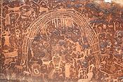 These pioneer settlements of the late 19th century were also the crossroads for other historic civilizations, such as the Fremont culture
. Emery County was an important center for the Fremont Culture which dates back to about 700 to 1000. The later Bull Creek phase (1000–1200) seems to have developed during a wet cycle that allowed for more extensive agriculture and larger dwelling groups. Several rock art panels surround Moore, such as the Rochester Rock Art Panel
.
Unincorporated area
In law, an unincorporated area is a region of land that is not a part of any municipality.To "incorporate" in this context means to form a municipal corporation, a city, town, or village with its own government. An unincorporated community is usually not subject to or taxed by a municipal government...
in west central Emery County
Emery County, Utah
Emery County is a county located in the U.S. state of Utah. As of 2000 the population was 10,860, and by 2009 had been estimated to decrease to 10,629. It was named for George W. Emery, governor of the Utah Territory in 1875...
, Utah
Utah
Utah is a state in the Western United States. It was the 45th state to join the Union, on January 4, 1896. Approximately 80% of Utah's 2,763,885 people live along the Wasatch Front, centering on Salt Lake City. This leaves vast expanses of the state nearly uninhabited, making the population the...
, United States
United States
The United States of America is a federal constitutional republic comprising fifty states and a federal district...
, at the edge of the San Rafael Swell
San Rafael Swell
The San Rafael Swell is a large geologic feature located in south-central Utah, USA about 30 miles west of Green River, Utah. The San Rafael Swell, approximately by , consists of a giant dome-shaped anticline of sandstone, shale, and limestone that was pushed up during the Paleocene Laramide...
. Moore is a community or populated place (Class Code U6) located in Emery County at latitude 38.967 and longitude -111.154. The elevation is 6,247 feet. Moore appears on the Emery East U.S. Geological Survey Map. The village is at the junction of County Routes County Road 801 and County Road 803 (known as the Moore Cut-off). The population was 5 at the 2000 census
United States Census, 2000
The Twenty-second United States Census, known as Census 2000 and conducted by the Census Bureau, determined the resident population of the United States on April 1, 2000, to be 281,421,906, an increase of 13.2% over the 248,709,873 persons enumerated during the 1990 Census...
.
Originally named Rochester for the hometown in New York of M. B. Whitney who was involved in the development of the area. About the same time Emery
Emery, Utah
Emery is a town in Emery County, Utah, United States. The population was 308 at the 2000 census.-Prehistoric:Emery sits at the base of the mountains that contain the North Horn Formation. Named after North Horn Mountain, near Castle Dale, Utah this formation in Emery County contain numerous...
was digging the Muddy Canal, financial investors from the Eastern States became aware of the lush, productive farmland on the flats east of the Muddy River headwaters. The investors saw the potential and formed The Independent Canal Company to claim water from the Muddy Creek
Muddy Creek
Muddy Creek may refer to:*Muddy Creek , a tributary of the Colorado River*Muddy Creek *Muddy Creek *Muddy Creek , a list of Muddy Creeks in the state*In Pennsylvania...
and coax this arid land into producing grain like in the Midwest.
Shares were offered to residents of Emery County, who also caught their vision. They began digging and blasting to build a new canal that would irrigate farmland and provide water. The town had a store, brick school, and post office.
In 1940 the community was renamed Moore after postmaster L. C. Moore who became the land development project leader for the area in 1907, when all of the Eastern investors had pulled out of the company. Only a few residents still live in Moore. Most residents have moved into neighboring towns but have kept their farmland which continues to produce great crops.
Fremont culture
The Fremont culture or Fremont people is a pre-Columbian archaeological culture which received its name from the Fremont River in the U.S. state of Utah where the first Fremont sites were discovered. The Fremont River itself is named for John Charles Frémont, an American explorer. It inhabited...
. Emery County was an important center for the Fremont Culture which dates back to about 700 to 1000. The later Bull Creek phase (1000–1200) seems to have developed during a wet cycle that allowed for more extensive agriculture and larger dwelling groups. Several rock art panels surround Moore, such as the Rochester Rock Art Panel
Rochester Rock Art Panel
The Rochester Rock Art Panel consists of a large number of petroglyphs of various ages. Some are prehistoric rock art, probably of Fremont culture origin. Others are probably modern, depicting horses, for example. And some are arguably of very recent origin, most likely the work of white...
.