

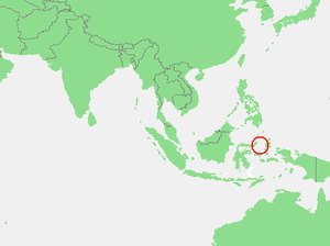
, within the country of Indonesia
. The region is rich in coral and has many diving sites.
Location
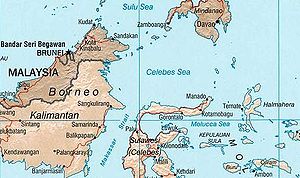
The Molucca Sea borders the Banda Seato the south and the Celebes Sea
to the north.
The islands bordering the Molucca Sea include Halmahera
to the north east, Buru
and Ceram
in the centre, and Sulawesi
to the west. The Talaud Islands
to the north are the general limit of the sea, though the Molucca Sea Plate
, the tectonic plate named after the sea, extends further north.
The International Hydrographic Organization
(IHO) defines the "Molukka Sea" as being one of the waters of the East Indian Archipelago
. The IHO defines its limits as follows:
On the North. By a line from the Northeast extreme of Celebes[ SulawesiSulawesiSulawesi is one of the four larger Sunda Islands of Indonesia and is situated between Borneo and the Maluku Islands. In Indonesia, only Sumatra, Borneo, and Papua are larger in territory, and only Java and Sumatra have larger Indonesian populations.- Etymology :The Portuguese were the first to...] through the Siau Islands to the South point of Sangi (3°21′N 125°37′E) thence to the Southern extreme of the Talaud GroupTalaud IslandsTalaud Islands is a group of islands located north of Sulawesi island in Indonesia, northeast of the Sangihe Islands...
, through these islands to their Northeastern extreme (4°29′N 126°52′E) and thence a line to Tanjong Sopi, the Northern point of Morotai IslandMorotaiMorotai Island Regency is a regency of North Maluku province, Indonesia, located on Morotai Island. The population was 54,876 in 2007.-History:...
.
On the East. By the West coast of Morotai from Tanjong Sopi as far South as Wajaboela (2°17′N 128°12′E), thence a line to the Northern point of Halmahera
HalmaheraHalmahera is the largest island in the Maluku Islands. It is part of the North Maluku province of Indonesia.Halmahera has a land area of 17,780 km² and a population in 1995 of 162,728...
and down its West coast to Tanjong Libolo, its Southern extreme.
On the South. A line from the Southern extreme of Halmahera to the North point of Bisa (Setile) Island, thence to the Northern extreme of Obi Major, through this island to Tanjong Ake Lamo, its Southwestern point, thence to Tanjong Dehekolano, the Eastern extremity of the Soela
[ SulaSula IslandsThe Sula Islands are a group of islands in North Maluku in Indonesia. Its three main islands are Mangole, Sanae and Taliabu, with smaller islands Lifamatola and Seho. It is administered as Kepulauan Sula Regency...] Islands, along their Northern coasts to Tanjong Marikasoe, the Western extreme, thence a line to the Southeast point of Banggai IslandBanggai IslandBanggai Island is the second largest of the Banggai Islands, an archipelago located at the far eastern end of Central Sulawesi, Indonesia. The largest island is Peleng, smaller islands of the group are Bowokan, Labobo, Kebongan, Kotudan, Tropettenando, Timpau, Salue Besar, Salue Kecil, Masepe, and...
(1°43′S 123°36′E).
On the West. The East coasts of Banggai and Peleng
PelengPeleng is an island off the East coast of Sulawesi, Indonesia and is the largest island of the Banggai Islands group of islands...
Islands to North Bangkalan (1°10′S 123°18′E) thence a line to Tg. Botok (Celebes) (1°04′S 123°19′E) round the coast to Tg. Pasir Pandjang (0°39′S 123°25′E) and across to Tg. Tombalilatoe (123°21'E) on the opposite coast, thence up the East coast to Tg. Poeisan, the Northeastern extreme of Celebes.