

Mist Trail
Encyclopedia
Yosemite National Park
Yosemite National Park is a United States National Park spanning eastern portions of Tuolumne, Mariposa and Madera counties in east central California, United States. The park covers an area of and reaches across the western slopes of the Sierra Nevada mountain chain...
, California
California
California is a state located on the West Coast of the United States. It is by far the most populous U.S. state, and the third-largest by land area...
, USA. The hike follows the Merced River
Merced River
The Merced River , in the central part of the U.S. state of California, is a -long tributary of the San Joaquin River flowing from the Sierra Nevada into the Central Valley. It is most well known for its swift and steep course through the southern part of Yosemite National Park, and the...
, starting at Happy Isles
Happy Isles
Happy Isles is a group of small isles in the Merced River in Yosemite National Park, California, USA. They are located at the easternmost end of the Yosemite Valley floor...
in Yosemite Valley
Yosemite Valley
Yosemite Valley is a glacial valley in Yosemite National Park in the western Sierra Nevada mountains of California, carved out by the Merced River. The valley is about long and up to a mile deep, surrounded by high granite summits such as Half Dome and El Capitan, and densely forested with pines...
, past Vernal Fall, Emerald Pool
Emerald Pool
Emerald Pool is the name of several locations.-Yosemite:Emerald Pool is a small, shallow lake located immediately above Vernal Fall in Yosemite National Park. It is named for its deep green color, which is caused by algae living on the rocks at the bottom of the pool...
, to Nevada Fall
Nevada Fall
Nevada Fall is a high waterfall on the Merced River in Yosemite National Park, California. It is located below the granite dome, Liberty Cap, at the west end of Little Yosemite Valley. The waterfall is widely recognized by its "bent" shape, in which the water free-falls for roughly the first third...
.
Description
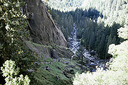
Along the trail, the Merced River is a tumultuous mountain stream, lying in a U-shaped valleyU-shaped valley
A U-shaped valley also known as a glacial trough is one formed by the process of glaciation. It has a characteristic U-shape, with steep, straight sides, and a flat bottom. Glaciated valleys are formed when a glacier travels across and down a slope, carving the valley by the action of scouring...
. Enormous boulders, some the size of a house, are dwarfed by the sheer faces of exfoliating granite, which rise 3000 feet (914 m) from the river. Through it all, the Merced river rushes down from its source in the High Sierra, and broadens on the floor of Yosemite Valley.
A trail which links to the John Muir Trail
John Muir Trail
The John Muir Trail is a long-distance trail in the Sierra Nevada mountain range of California, running between the northern terminus at Happy Isles in Yosemite Valley and the southern terminus located on the summit of Mount Whitney . For almost all of its length, the trail is in the High Sierra...
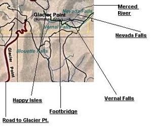
starts after crossing from the Happy Isles. Depending on one's conditioning, a bridge which re-crosses the river – the halfway point of a hike to the foot of Vernal Fall – can be reached in 15 to 30 minutes.
Works Progress Administration
The Works Progress Administration was the largest and most ambitious New Deal agency, employing millions of unskilled workers to carry out public works projects, including the construction of public buildings and roads, and operated large arts, drama, media, and literacy projects...
projects of the 1930s. Here is where raingear becomes handy: in the spring, hikers often become completely drenched from water sprayed off Vernal Fall. This is one of the few places where a complete circular rainbow
Rainbow
A rainbow is an optical and meteorological phenomenon that causes a spectrum of light to appear in the sky when the Sun shines on to droplets of moisture in the Earth's atmosphere. It takes the form of a multicoloured arc...
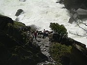
can be viewed. The trail now crosses a sheer face which is made somewhat easier by a single guard rail. At the top of Vernal Fall, the Merced river traverses a shelf of granite, and the hikers frequently sun themselves to dry off.
The Emerald Pool is named for the color of the river here.
Up the trail, Nevada Falls, a waterfall that is over twice the height of Vernal Falls, awaits the hiker, although there is no cascade of mist over the trail at that waterfall. Behind Nevada Falls is Liberty Cap
Liberty Cap (California)
Liberty Cap is a granite dome in Yosemite National Park, California, USA which lies at the extreme northwestern margin of Little Yosemite Valley. It lies adjacent, to the north of Nevada Fall, on the John Muir Trail. It rises feet from the base of Nevada Fall to a peak elevation of . A smaller,...
, an impressive lump of granite. The Mist trail then rejoins the John Muir Trail: the hiker can travel in Little Yosemite Valley
Little Yosemite Valley
Little Yosemite Valley is, as the name implies, a smaller glacial valley upstream in the Merced River drainage from the Yosemite Valley in Yosemite National Park. The Merced River meanders through the long flat valley, draining out over Nevada Fall and Vernal Fall before emptying into the main...
, or take a side trip to the top of Half Dome
Half Dome
Half Dome is a granite dome in Yosemite National Park, located in northeastern Mariposa County, California, at the eastern end of Yosemite Valley — possibly Yosemite's most familiar rock formation. The granite crest rises more than above the valley floor....
, using cables to climb the rock.
Logistics
Hikers are cautioned that they should register a plan with the rangers so that their safety can be monitored; in this day of cell phones, that advice may seem unnecessary, but a cell phone can always be lost or broken and the loss of service is common on the trail.
Beyond the Mist Trail, on the John Muir Trail, hikers may find themselves sharing the trail with a horse and rider; etiquette and safety demand that hikers yield to the horses, because if someone spooks the horse, both horse and rider may be pitched down the mountainside.
Related hikes
- The High Sierra CampsHigh Sierra CampsThe High Sierra Camps are nine rustic lodging facilities located in two national parks and a national monument in California's Sierra Nevada mountain range. Open most years from June or July to September, they are staffed camps with tent cabins and food service facilities. The backcountry camps...
provide a loop through the Yosemite backcountry, with tent cabins spaced one days' hike apart. - A panoramic view of the Mist Trail can be had from Glacier PointGlacier Pointthumb|right|upright|Glacier Point, as seen from [[Yosemite Valley]]. In springtime, this cliff face is covered with dozens of freshets and tiny waterfalls from the snowmelt, the largest being [[Staircase Falls]]....
, 3000 feet (900 m) above, looking north. During the summer, shuttle buses from the floor of the valley will take an hour to arrive at Glacier Point. - The John Muir TrailJohn Muir TrailThe John Muir Trail is a long-distance trail in the Sierra Nevada mountain range of California, running between the northern terminus at Happy Isles in Yosemite Valley and the southern terminus located on the summit of Mount Whitney . For almost all of its length, the trail is in the High Sierra...
starts at the same trailhead as the Mist Trail.