

Misfit stream
Encyclopedia
Stream
A stream is a body of water with a current, confined within a bed and stream banks. Depending on its locale or certain characteristics, a stream may be referred to as a branch, brook, beck, burn, creek, "crick", gill , kill, lick, rill, river, syke, bayou, rivulet, streamage, wash, run or...
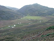
that is far too small to have eroded the valley
Valley
In geology, a valley or dale is a depression with predominant extent in one direction. A very deep river valley may be called a canyon or gorge.The terms U-shaped and V-shaped are descriptive terms of geography to characterize the form of valleys...
which the stream occupies. The shape of the valley may also be inconsistent with a typical valley that has been eroded by water. Generally it is reasonable to expect a valley
Valley
In geology, a valley or dale is a depression with predominant extent in one direction. A very deep river valley may be called a canyon or gorge.The terms U-shaped and V-shaped are descriptive terms of geography to characterize the form of valleys...
to be in proportion with the stream that occupies it. When a period of glaciation modifies the landscape by creating glacial troughs
U-shaped valley
A U-shaped valley also known as a glacial trough is one formed by the process of glaciation. It has a characteristic U-shape, with steep, straight sides, and a flat bottom. Glaciated valleys are formed when a glacier travels across and down a slope, carving the valley by the action of scouring...
the rivers that occupy such valleys after the ice has retreated are not in proportion with the size of the valley
Valley
In geology, a valley or dale is a depression with predominant extent in one direction. A very deep river valley may be called a canyon or gorge.The terms U-shaped and V-shaped are descriptive terms of geography to characterize the form of valleys...
. Given the scale of most glacial troughs
U-shaped valley
A U-shaped valley also known as a glacial trough is one formed by the process of glaciation. It has a characteristic U-shape, with steep, straight sides, and a flat bottom. Glaciated valleys are formed when a glacier travels across and down a slope, carving the valley by the action of scouring...
almost all of them contain misfit streams.
Alternative causes
Misfit streams can be caused by reductions in the dischargeDischarge (hydrology)
In hydrology, discharge is the volume rate of water flow, including any suspended solids , dissolved chemical species and/or biologic material , which is transported through a given cross-sectional area...
of the stream. Channel size responds rapidly to variations in discharge
Discharge (hydrology)
In hydrology, discharge is the volume rate of water flow, including any suspended solids , dissolved chemical species and/or biologic material , which is transported through a given cross-sectional area...
, but valley size responds over much longer timescales. Many causes of reduced discharges
Discharge (hydrology)
In hydrology, discharge is the volume rate of water flow, including any suspended solids , dissolved chemical species and/or biologic material , which is transported through a given cross-sectional area...
are possible. If misfit streams are widespread in an area climate change
Climate change
Climate change is a significant and lasting change in the statistical distribution of weather patterns over periods ranging from decades to millions of years. It may be a change in average weather conditions or the distribution of events around that average...
, particularly a reduction in precipitation
Precipitation (meteorology)
In meteorology, precipitation In meteorology, precipitation In meteorology, precipitation (also known as one of the classes of hydrometeors, which are atmospheric water phenomena is any product of the condensation of atmospheric water vapor that falls under gravity. The main forms of precipitation...
is likely to be the cause. If a single river appears to be a misfit stream it may be as a result of anthropogenic interference through groundwater
Groundwater
Groundwater is water located beneath the ground surface in soil pore spaces and in the fractures of rock formations. A unit of rock or an unconsolidated deposit is called an aquifer when it can yield a usable quantity of water. The depth at which soil pore spaces or fractures and voids in rock...
extraction or dam
Dam
A dam is a barrier that impounds water or underground streams. Dams generally serve the primary purpose of retaining water, while other structures such as floodgates or levees are used to manage or prevent water flow into specific land regions. Hydropower and pumped-storage hydroelectricity are...
construction upstream. Natural causes include stream capture or other changes in drainage patterns. For instance, New Zealand's largest river (the Waikato
Waikato River
The Waikato River is the longest river in New Zealand. In the North Island, it runs for 425 kilometres from the eastern slopes of Mount Ruapehu, joining the Tongariro River system and emptying into Lake Taupo, New Zealand's largest lake. It drains Taupo at the lake's northeastern edge, creates the...
) used to flow through the Hauraki Plains
Hauraki Plains
The Hauraki Plains are a geographical feature and non-administrative area located in the northern North Island of New Zealand, at the lower end of the Thames Valley...
to the North Island
North Island
The North Island is one of the two main islands of New Zealand, separated from the much less populous South Island by Cook Strait. The island is in area, making it the world's 14th-largest island...
's east coast, but changed its course to exit on the west coast due to a large volcanic eruption
Oruanui eruption
The Oruanui eruption of New Zealand's Taupo Volcano was the world's largest known eruption in the past 70,000 years, with a Volcanic Explosivity Index of 8...
, leaving its former course through the 1-km wide Hinuera Gap occupied by only a small stream.
A misfit stream can also be caused by a glacier. A glacier forms a U shaped valley. The river is cut off from its normal path and forms a hanging valley and goes into the U shape valley. This valley is far too big so it is a misfit stream
Example
- A misfit stream named Nose Creek in CalgaryCalgaryCalgary is a city in the Province of Alberta, Canada. It is located in the south of the province, in an area of foothills and prairie, approximately east of the front ranges of the Canadian Rockies...
, AlbertaAlbertaAlberta is a province of Canada. It had an estimated population of 3.7 million in 2010 making it the most populous of Canada's three prairie provinces...
: 51°7′56"N 114°3′39"W