

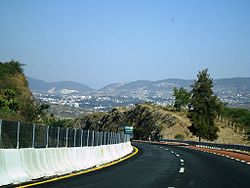
Mexican Federal Highway 95
Encyclopedia
Mexican Federal Highway 95 (Carretera Federal 95) connects Mexico City
to Acapulco
, Guerrero
.
The highway is the main road that leads to the Lagunas de Zempoala National Park
. At Tlalpan, Mexico City, the Highway serves the Estadio Azteca
.
ordered the construction of a passage in order to move supplies between the capital and the coastal city. It was converted into a more solid road and received the name Asia Road due to the passage of wares along it.
In early 1920 Juan R. Escudero, who was originally from Acapulco, asked President Alvaro Obregón
to expedite the construction of the road, Escudero offering a group of his men to support the construction work. Obregón agreed and proceeded to improve sections Mexico-Amacuzac
and the Iguala
-Chilpancingo
. A year later, he improved the stretch that runs from Chilpancingo to the south towards Acapulco, and also began a better line of road north of Acapulco.
After the murder of Escudero late 1923, the emergence of the Huerta rebellion and pressure from the bourgeoisie in Acapulco, the work would be stopped again for a short period. Between the years 1924 and 1925, the work was restarted by Amadeo S. Vidales, who was appointed head of the Guerrero area and with the support of a group of 328 men, whose salaries he paid.
. The next 3.4 kilometres ascend the mountainous areas of the Yoyolica volcano, before passing though the population centre of Los Angeles. The road continues south through the outskirts of the town of Parras
which leads to Chichinautzin Microwave Station. Finally, it covers a stretch of 8.6 km to the town of El Capulin, is in this section that leaves the Federal District and into the state of Morelos.
to reach the city of Cuernavaca
, the state capital. Upon admission to it, starting a stretch where the road becomes divided Not Free State Road. Leaving the city, the road continues towards the south to the junction with the road to Cuernavaca Airport in this area there are a number of junctions and intersections of roads that connect the villages of Puente Morelos, Xochitepec and Tletama.
The road continues south to another junction with Highway 166
in the town of Alpuyeca, Highway 166 continues towards the north-west and passes through other areas, such as Miacatlán
, Mazatepec
, Tetecala de las Reformas, among others. Highway 95 continues south in a stretch where there are outlets for people of Coatetelco
and Ahuehuetzingo and through the towns of Loma Larga and El Abinico, the latter three belonging to the municipality of Puente de Ixtla
. Subsequently, the road crosses near the towns of Puente de Ixtla and San Gabriel de las Palmas to where it joins again with Highway 166 and once again immediately after the city of Amacuzac. In this area, the road changes its orientation towards the west through the towns of Huajintlán, Teacalco and the town of Casino de la Union. This is the last stretch of the highway before entering the state of Guerrero
.
The road now meets with State Highway 1 which connects the city of Iguala and the cityof Tepecoacuilco, Huitzuco. Further south, the route 95 is located with other road inputs to populations of the municipalities of Iguala de la Independencia and Tepecoacuilco of Trujano como Zacacoyuca, Santa Teresa, Sabana Grande, Sale Palulo, Maxela, Coacoyula Alvarez, Xalitla and Valerio Trujano. From this section, Highway 95 goes into Cañón del Zopilote (Buzzard Canyon), in the municipality of Eduardo Neri, crossing the bridge over the Balsas River (known in this area as Mezcala) and near the town of Mezcal.
Further south, the road meets a junction near the archealogical site at La Organera-Xochipala
. Subsequently, it crosses the town of El Pantanal, where there is a free state road that bisects Huitziltepec. The route then crosses through the city from the Zumpango River and then travels 8 miles toward the state capital Chilpancingo de los Bravo. The highway joins the Autopista del Sol. Leaving the urban area, the road provides access to Mazatlan, Palo Blanco, Agua de Obispo, Rincon de la Via, Ocotito and Julian Blanco which belongs to Municipality of Chilpancingo de los Bravo. The road enters the town of Juan R. Escudero and through the Tierra Colorada and then out toward the west-southwest and across the Papagayo River. It is at this point that the road enters the city of Acapulco and passes near the town of El Playon, through the town of Xaltianguis, Potrerillos River bridge and the locations of El Cuarenta y Cinco and Cuarenta y Dos. In the latter there is a cruise that leads to Piedra Iman and La Providencia. Later, it passes near the towns of El Cuerenta and El Treinta y Cuatro where a road linking the towns of Dos Arroyos, Colonia Guerrero, Altos de Camaron and Venta Vieja.
Finally, Highway 95 passes near the town of Lomas de San Juan and meets with Highway 200
from the region of Costa Chica, on this stretch of Highway 200 and 95 come togetherin an attempt to bypass the city of Acapulco in order to save time. The road crosses around the towns of El Veinteuno, El Paso Quemado and Limon and finally to the city of Acapulco
.
Mexico City
Mexico City is the Federal District , capital of Mexico and seat of the federal powers of the Mexican Union. It is a federal entity within Mexico which is not part of any one of the 31 Mexican states but belongs to the federation as a whole...
to Acapulco
Acapulco
Acapulco is a city, municipality and major sea port in the state of Guerrero on the Pacific coast of Mexico, southwest from Mexico City. Acapulco is located on a deep, semi-circular bay and has been a port since the early colonial period of Mexico’s history...
, Guerrero
Guerrero
Guerrero officially Estado Libre y Soberano de Guerrero is one of the 31 states which, with the Federal District, comprise the 32 Federal Entities of Mexico. It is divided in 81 municipalities and its capital city is Chilpancingo....
.
The highway is the main road that leads to the Lagunas de Zempoala National Park
Lagunas de Zempoala National Park
Lagunas de Zempoala National Park is a natural protected area which consists of a group of seven lagoons...
. At Tlalpan, Mexico City, the Highway serves the Estadio Azteca
Estadio Azteca
Estadio Azteca is a stadium in Santa Ursula, Mexico City, Mexico. It is the official home stadium of the Mexico national football team and the Mexican team Club América.The stadium was the venue for football soccer in the 1968 Summer Olympics....
.
History
The oldest reference to a road between Mexico City and Acapulco date to 1531, when Hernán CortésHernán Cortés
Hernán Cortés de Monroy y Pizarro, 1st Marquis of the Valley of Oaxaca was a Spanish Conquistador who led an expedition that caused the fall of the Aztec Empire and brought large portions of mainland Mexico under the rule of the King of Castile in the early 16th century...
ordered the construction of a passage in order to move supplies between the capital and the coastal city. It was converted into a more solid road and received the name Asia Road due to the passage of wares along it.
In early 1920 Juan R. Escudero, who was originally from Acapulco, asked President Alvaro Obregón
Álvaro Obregón
General Álvaro Obregón Salido was the President of Mexico from 1920 to 1924. He was assassinated in 1928, shortly after winning election to another presidential term....
to expedite the construction of the road, Escudero offering a group of his men to support the construction work. Obregón agreed and proceeded to improve sections Mexico-Amacuzac
Amacuzac
Amacuzac is a city in the Mexican state of Morelos.It stands at , at a mean height of 982 metres above sea level.The city serves as the municipal seat for the surrounding municipality of the same name....
and the Iguala
Iguala
The historic city of Iguala de la Independencia is located from state capital Chilpancingo in the Mexican state of Guerrero. It stands on Federal Highway 95. Iguala is the municipal seat of the municipality of the same name, located in the north-central part of the state. The city had a 2005...
-Chilpancingo
Chilpancingo
Chilpancingo de los Bravo is the capital and second-largest city of the state of Guerrero, Mexico. It is located at . In the 2005 census the population of the city was 166,796. Its surrounding municipality, of which it is municipal seat, had a population of 214,219 persons...
. A year later, he improved the stretch that runs from Chilpancingo to the south towards Acapulco, and also began a better line of road north of Acapulco.
After the murder of Escudero late 1923, the emergence of the Huerta rebellion and pressure from the bourgeoisie in Acapulco, the work would be stopped again for a short period. Between the years 1924 and 1925, the work was restarted by Amadeo S. Vidales, who was appointed head of the Guerrero area and with the support of a group of 328 men, whose salaries he paid.
Federal District
Federal Highway 95 begins in Mexico City at the end of the avenues Insurgentes and Viaductio Tlalpan. They begin heading out towards the south for 6.6 kilometres, passing though the population centre of San Andres TotoltepecTotoltepec de Guerrero (municipality)
Totoltepec de Guerrero is a town and municipality in Puebla in south-eastern Mexico.-References:...
. The next 3.4 kilometres ascend the mountainous areas of the Yoyolica volcano, before passing though the population centre of Los Angeles. The road continues south through the outskirts of the town of Parras
Parras
Parras de la Fuente is a city located in the southern part of the Mexican state of Coahuila. At the census of 2010, the population was 45,423. There are a large number of factories that produce denim, including a Dickies factory, and Parras is also a wine-making place...
which leads to Chichinautzin Microwave Station. Finally, it covers a stretch of 8.6 km to the town of El Capulin, is in this section that leaves the Federal District and into the state of Morelos.
Distances
- Leaving Mexico City and San Andres Totoltepec — 6.6 km
- to Los Ángeles — 3.4 km
- Los Ángeles to Parres — 10.12 km
- Parres to El Capulín(MorelosMorelosMorelos officially Estado Libre y Soberano de Morelos is one of the 31 states which, with the Federal District, comprise the 32 Federal Entities of Mexico. It is divided in 33 municipalities and its capital city is Cuernavaca....
) — 8.6 km
Morelos
The road comes from the Federal District into the state of Morelos from north to south through the towns of El Capulin and the Tres Marias municipality of HuitzilacHuitzilac
Huitzilac is a city in the Mexican state of Morelos. It stands at and at an altitude of 2,561 m. above sea level.The city serves as the municipal seat for the surrounding municipality of the same name...
to reach the city of Cuernavaca
Cuernavaca
Cuernavaca is the capital and largest city of the state of Morelos in Mexico. It was established at the archeological site of Gualupita I by the Olmec, "the mother culture" of Mesoamerica, approximately 3200 years ago...
, the state capital. Upon admission to it, starting a stretch where the road becomes divided Not Free State Road. Leaving the city, the road continues towards the south to the junction with the road to Cuernavaca Airport in this area there are a number of junctions and intersections of roads that connect the villages of Puente Morelos, Xochitepec and Tletama.
The road continues south to another junction with Highway 166
Mexican Federal Highway 166
Mexican Federal Highway 166 is a Federal Highway of Mexico....
in the town of Alpuyeca, Highway 166 continues towards the north-west and passes through other areas, such as Miacatlán
Miacatlán
Miacatlán is a city in the Mexican state of Morelos. It stands at .The city serves as the municipal seat for the surrounding municipality of the same name...
, Mazatepec
Mazatepec
Mazatepec is a city in the Mexican state of Morelos. It standsat .The city serves as the municipal seat for the surrounding municipality of the same name.The municipality reported 8,821 inhabitants in the year 2000 census....
, Tetecala de las Reformas, among others. Highway 95 continues south in a stretch where there are outlets for people of Coatetelco
Coatetelco
Coatetelco or Cuatetelco, is a prehispanic archaeological site located next to the Coatetelco Lagoon, two kilometers from Alpuyeca, in the Miacatlán municipality, Morelos State, México, near Xochicalco, had an important development between 500 y 150 BCE....
and Ahuehuetzingo and through the towns of Loma Larga and El Abinico, the latter three belonging to the municipality of Puente de Ixtla
Puente de Ixtla
Puente de Ixtla is a city in the Mexican state of Morelos. It stands at .The city serves as the municipal seat for the surrounding municipality of the same name...
. Subsequently, the road crosses near the towns of Puente de Ixtla and San Gabriel de las Palmas to where it joins again with Highway 166 and once again immediately after the city of Amacuzac. In this area, the road changes its orientation towards the west through the towns of Huajintlán, Teacalco and the town of Casino de la Union. This is the last stretch of the highway before entering the state of Guerrero
Guerrero
Guerrero officially Estado Libre y Soberano de Guerrero is one of the 31 states which, with the Federal District, comprise the 32 Federal Entities of Mexico. It is divided in 81 municipalities and its capital city is Chilpancingo....
.
Distances
- Junction of Huitzilac and Zempoala Lakes National ParkLagunas de Zempoala National ParkLagunas de Zempoala National Park is a natural protected area which consists of a group of seven lagoons...
to area of Coajomulco - 5 km - From Coajomulco to the junction at HuitzilacHuitzilacHuitzilac is a city in the Mexican state of Morelos. It stands at and at an altitude of 2,561 m. above sea level.The city serves as the municipal seat for the surrounding municipality of the same name...
- 9 km - to Tepoztlan Huitzilac - 6 km
- to the city of CuernavacaCuernavacaCuernavaca is the capital and largest city of the state of Morelos in Mexico. It was established at the archeological site of Gualupita I by the Olmec, "the mother culture" of Mesoamerica, approximately 3200 years ago...
— 5 km - Cuernavaca to Temixco - 10 km
- to Acatlipa - 3 km
- to the town of Puente Morelos - 2 km
- to Palo Bolero - 5 km
- to the road junction of Xoxocotla - 5 km
- XoxocotlaXoxocotlaXoxocotla is a municipality located in the south zone in the State of Veracruz, about 100 km from state capital Xalapa. It has a surface of 63.34 km2. It is located at...
junction to the junction to Mazatepec - 3 km - Mazatepec to Ahuehuetzingo - 4 km
- Ahuehuetzingo to Puente de IxtlaPuente de IxtlaPuente de Ixtla is a city in the Mexican state of Morelos. It stands at .The city serves as the municipal seat for the surrounding municipality of the same name...
- 7 km - Puente de Ixtla to - 12 km
- Amacuzac the intersection with Federal Highway 55Mexican Federal Highway 55Mexican Federal Highway 55 is a Federal Highway of Mexico. The highway connects San Juan del Río, Querétaro to the north and Apuyeca, Morelos to the south. Apuyeca is a locale of the municipality of Xochitepec, Morelos....
(at Guerrero) - 16 km
Guerrero
In the state of Guerrero, Highway 95 enters near Cacahuamilpa Caves National Park, the road follows its course and enters the city of Ixtapan de la Sal. It continues its path past the area of Tetipac and passing near the town of Acuitlapan and Acamixtla where it reaches the city of Taxco de Alarcón. In this city, the road turns to the south again; it passes Tecalpulco, Taxco El Viejo, Campuzano Puente, San Juan de la Union and Mexcaltepec,(all in the municipality of Taxco de Alarcón) and El Naranjo's town of Iguala de la Independencia.The road now meets with State Highway 1 which connects the city of Iguala and the cityof Tepecoacuilco, Huitzuco. Further south, the route 95 is located with other road inputs to populations of the municipalities of Iguala de la Independencia and Tepecoacuilco of Trujano como Zacacoyuca, Santa Teresa, Sabana Grande, Sale Palulo, Maxela, Coacoyula Alvarez, Xalitla and Valerio Trujano. From this section, Highway 95 goes into Cañón del Zopilote (Buzzard Canyon), in the municipality of Eduardo Neri, crossing the bridge over the Balsas River (known in this area as Mezcala) and near the town of Mezcal.
Further south, the road meets a junction near the archealogical site at La Organera-Xochipala
Xochipala
Xochipala is a minor archaeological site in the Mexican state of Guerrero, whose name has become attached, somewhat erroneously, to a style of Formative Period figurines and pottery.-Archaeological site:...
. Subsequently, it crosses the town of El Pantanal, where there is a free state road that bisects Huitziltepec. The route then crosses through the city from the Zumpango River and then travels 8 miles toward the state capital Chilpancingo de los Bravo. The highway joins the Autopista del Sol. Leaving the urban area, the road provides access to Mazatlan, Palo Blanco, Agua de Obispo, Rincon de la Via, Ocotito and Julian Blanco which belongs to Municipality of Chilpancingo de los Bravo. The road enters the town of Juan R. Escudero and through the Tierra Colorada and then out toward the west-southwest and across the Papagayo River. It is at this point that the road enters the city of Acapulco and passes near the town of El Playon, through the town of Xaltianguis, Potrerillos River bridge and the locations of El Cuarenta y Cinco and Cuarenta y Dos. In the latter there is a cruise that leads to Piedra Iman and La Providencia. Later, it passes near the towns of El Cuerenta and El Treinta y Cuatro where a road linking the towns of Dos Arroyos, Colonia Guerrero, Altos de Camaron and Venta Vieja.
Finally, Highway 95 passes near the town of Lomas de San Juan and meets with Highway 200
Mexican Federal Highway 200
Mexican Federal Highway 200 is also known as Carretera Pacifico and is a Federal Highway of Mexico. Carretera Pacifico is the main leg of the Pacific Coastal Highway within Mexico and runs along the Pacific Coast from Mexican Federal Highway 15 in the north to the Guatemalan border in the south...
from the region of Costa Chica, on this stretch of Highway 200 and 95 come togetherin an attempt to bypass the city of Acapulco in order to save time. The road crosses around the towns of El Veinteuno, El Paso Quemado and Limon and finally to the city of Acapulco
Acapulco
Acapulco is a city, municipality and major sea port in the state of Guerrero on the Pacific coast of Mexico, southwest from Mexico City. Acapulco is located on a deep, semi-circular bay and has been a port since the early colonial period of Mexico’s history...
.
Sources
- Liquidano Doria, Faustino; Liquidano Dimayuga, Eleuteria(1994). «Siglo XVI», Memoria de Acapulco. Acapulco, Guerrero: Ediciones Municipales.
- Martínez Carbajal, Alejandro (2005). «Etapa Revolucionaria: La Carretera México-Acapulco», Historia de Acapulco, Primera edición, Acapulco, Guerrero: DPA Impresores.
- Escudero, Francisco R. (1997). «II: La Esperanza: La Carretera Federal México-Acapulco», Origen y evolución del turismo en Acapulco, Acapulco, Guerrero.